-
 Moorabbin Air Museum
Plan (item), Lock Spring Elec. Connector SD - E 268
-
Moorabbin Air Museum
Manual (item) - AAP 7276.141-3Dassault Droop Leading Edge Jack Type No 106-51
-
Moorabbin Air Museum
Manual (item) - Douglas DC-9 Illustrated Parts Catalogue, Douglas DC-4 Illustrated Parts Catalog
Douglas Aircraft Co.Inc -
Bendigo Historical Society Inc.
Map - GEOLOGICAL MAP OF BENDIGO GOLD FIELD
Map of Bendigo gold field showing anticlines, synclines, shaft, alluvial deposits and contour lines. Map is in two sections. This map forms part of the Geological Survey of Victoria, Structure of Bendigo Goldfield report, No. 47, 1923. H.Herman, late Director of Geological Survey.Geological Survey Victoriabendigo, gold mining, geological map -
Moorabbin Air Museum
Manual (Item) - Mirage Iiio Aircraft Planned Servicing Schedule R2 Servicing
Description: SUPERSEDES AAP 7213.001-6-3, PUBLISHED MARCH 1977. 32 pages. Published by RAAF. Published February 1980. AAP 7213.001-6-1-3 Level of Importance: World. -
Moorabbin Air Museum
Manual (item) - Rolls Royce Avon 1, 20 & 100 series overhaul manual
Avon engines -
 Whitehorse Historical Society Inc.
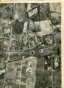
Map, Photo-map Ringwood A4A, 1945
Aerial photo covering approximately from Box Hill to Mitcham (West to East) and Springfield Road to Hawthorn Road (North to south).Aerial photo covering approximately from Box Hill to Mitcham (West to East) and Springfield Road to Hawthorn Road (North to south). Names of main roads inscribed.Aerial photo covering approximately from Box Hill to Mitcham (West to East) and Springfield Road to Hawthorn Road (North to south).aerial photographs, box hill, blackburn, nunawading, forest hill, mitcham -
Bendigo Historical Society Inc.
Map - CAMPBELL COLLECTION: BENDIGO AND DISTRICT MAPS, 8-7-29
Map. Rifle Range, Parishes of Wellsford and Sandhurst. Scale 20 chains to 1 inch. Total area in plan is 5916 acres. Wallan and Bendigo Railway to Axedale Township and station 8 miles, to Longlea Railway Station 2 1/2 - 3 miles. Rifle Range. Compiled in W.P.B. from Assessment and Parish Plans, by H.A.D. 8-7-29H.A.D.(Darby).map, bendigo, allotments -
Bendigo Historical Society Inc.
Map - REDCASTLE, 15/10/1878
Map: Redcastle, County of Rodney. Parish plan. (number 293 in map cupboard 1)map, rodney, parish plan, redcastle -
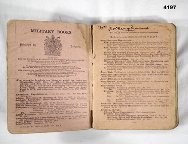 Bendigo Military Museum
Manual - MILITARY MANUAL, Infantry Training 1914, 1914
Manual, Military, heavy cardboard cover with orange woven cotton cover pasted on. manual is in 4 sections, 16 pink pages of Military books published by Authority, 18 white pages of contents, 265 white pages of training manual and last 7 pink pages of Military books published. All pages have black print and illustrations.Gold print on Spine “Infantry Training 1914” , In black ink page 3 “W Polkinghorne”, in black printed edge of book, “W Polkinghorne C B.H.S.”infantry training 1914, military, manuals -
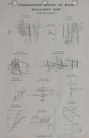 Federation University Historical Collection
Plan, Underground Survey of Mines, Ballaarat East Sections, c1890
Printed plan showing cross sections of various mine shaftsplan, underground survey, ballaarat east, mining -
Moorabbin Air Museum
Manual (item) - Australian "Beaufort" Tailwheel Type Record and Stressing Report, Landing Gear Hydraulic Equipment
-
Port Melbourne Historical & Preservation Society
Plan - Proposed extensions, Heath Street, Port Melbourne Town Hall, E J Pembroke, 15 Oct 1936
Floor plans, elevations to Heath street; south end; roof plan for proposed extensions to supper room Town Hall 1936. Coloured plans."City of Port Melbourne . Proposed Extensions to Supper Room . Town Hall"port melbourne town hall, pembroke and turner, e j pembroke -
Moorabbin Air Museum
Manual (Item) - Photographic Equipment - Data book of General & Technical info - RAAF
-
Moorabbin Air Museum
Manual (Item) - C130A Electrical Organisational Maintenance Manual - USAF
-
 Kew Historical Society Inc
Plan, Melbourne & Metropolitan Board of Works : Borough of Kew : Detail Plan No.1571, 1904
The Melbourne and Metropolitan Board of Works (MMBW) plans were produced from the 1890s to the 1950s. They were crucial to the design and development of Melbourne's sewerage and drainage system. The plans, at a scale of 40 feet to 1 inch (1:480), provide a detailed historical record of Melbourne streetscapes and environmental features. Each plan covers one or two street blocks (roughly six streets), showing details of buildings, including garden layouts and ownership boundaries, and features such as laneways, drains, bridges, parks, municipal boundaries and other prominent landmarks as they existed at the time each plan was produced. (Source: State Library of Victoria)This plan forms part of a large group of MMBW plans and maps that was donated to the Society by the Mr Poulter, City Engineer of the City of Kew in 1989. Within this collection, thirty-five hand-coloured plans, backed with linen, are of statewide significance as they include annotations that provide details of construction materials used in buildings in the first decade of the 20th century as well as additional information about land ownership and usage. The copies in the Public Record Office Victoria and the State Library of Victoria are monochrome versions which do not denote building materials so that the maps in this collection are invaluable and unique tools for researchers and heritage consultants. A number of the plans are not held in the collection of the State Library of Victoria so they have the additional attribute of rarity.Original survey plan, issued by the MMBW to a contractor with responsibility for constructing sewers in the area identified on the plan within the Borough of Kew. The plan was at some stage hand-coloured, possibly by the contractor, but more likely by officers working in the Engineering Department of the Borough and later Town, then City of Kew. The hand-coloured sections of buildings on the plan were used to denote masonry or brick constructions (pink), weatherboard constructions (yellow), and public buildings (grey). This plan is the other half of Plan No.1571 representing the constructions to the west of Wellington Street before and in 1903/4. This plan represents the built environment in Edgevale Road, Wellington Street, Atkins Street, Annadale Street, Mortimer Street, and Cotham Road. Whereas there are smaller allotments and more modest housing stock facing Edgevale Road, larger blocks and more substantial houses are represented facing Cotham Road.melbourne and metropolitan board of works, detail plans, mmbw 1571, cartography -
Moorabbin Air Museum
Manual (Item) - Admiralty Ref 110A-0300-1F6 Textbook of Air Armament Part 6 Chap 6 Dive Bombsights
-
Bendigo Historical Society Inc.
Map - EGERTON : COUNTY OF BENDIGO, 1-3-30
Map. Egerton, County of Bendigo, Minto, Diggorra, Elmore, Nolan, Goornong, Bagshot, Whirrakee. Bendigo Creek. By authority J.J. Green, Govt. Printer. Photo-Lithographed at the Department of Lands and Survey, Melbourne. Price 2/-. 1-3-30. (number 47 in map cupboard 1)J.J. Green, Govt. Printer.map, bendigo, egerton -
Glenelg Shire Council Cultural Collection
Plan - Plans / Line Drawings - Port of Portland Slipway bilge blocks, fishing vessel Kosmo, Portland, Victoria, 13/01/1988
PORT OF PORTLAND AUTHORITYFront: '1' black texta, top right corner -
Moorabbin Air Museum
Manual (Item) - RAAF - Non-Destructive Inspection Macchi Aircraft, Non-Destructive Inspection Macchi Aircraft
-
 Bendigo Historical Society Inc.
Map - JACK FLYNN COLLECTION: BAMAWM, 19/08/1924
Map: Parish of Bamawm, County of Bendigo. Parish plan.Photo Lithographed at the Department of Lands and Survey, Melbourne by W.J. Butson. 19.8.24map, bendigo, parish plan, bamawm -
Bialik College
Plan (item) - Bialik College development, 1979-1980
Architectural plans of proposed Bialik College, 429 Auburn Road, Hawthorn East, created by architects Joshua and Mary Pila, May 1979-1980. Please contact [email protected] to request access to this record.1970s, 1980s, building and planning -
Moorabbin Air Museum
Manual (item) - CAC Commonwealth Aircraft Corporation Library Range Calibrators, Operation & Service Instructions for Range Calibrator Set AN/UPM-11
Commonwealth Aircraft Corporation -
Moorabbin Air Museum
Manual (item) - ATAR Engine Production Cradle Diagram, ATAR Production Cradle Installation No. 2 Test Cell
-
Moorabbin Air Museum
Manual (Item) - Technical Training Manual - Administration I
-
Moorabbin Air Museum
Manual (item) - Lycoming Parts Catalogue Model 0-360 and I0-360 Series Aircraft Engines
-
 Kew Historical Society Inc
Plan, Melbourne & Metropolitan Board of Works. Borough of Kew Detail Plan No.1579, 1904
The Melbourne and Metropolitan Board of Works (MMBW) plans were produced from the 1890s to the 1950s. They were crucial to the design and development of Melbourne's sewerage and drainage system. The plans, at a scale of 40 feet to 1 inch (1:480), provide a detailed historical record of Melbourne streetscapes and environmental features. Each plan covers one or two street blocks (roughly six streets), showing details of buildings, including garden layouts and ownership boundaries, and features such as laneways, drains, bridges, parks, municipal boundaries and other prominent landmarks as they existed at the time each plan was produced. (Source: State Library of Victoria). This plan forms part of a large group of MMBW plans and maps that was donated to the Society by the Mr Poulter, City Engineer of the City of Kew in 1989. Within this collection, thirty-five hand-coloured plans, backed with linen, are of statewide significance as they include annotations that provide details of construction materials used in buildings in the first decade of the 20th century as well as additional information about land ownership and usage. The copies in the Public Record Office Victoria and the State Library of Victoria are monochrome versions which do not denote building materials so that the maps in this collection are invaluable and unique tools for researchers and heritage consultants. A number of the plans are not held in the collection of the State Library of Victoria so they have the additional attribute of rarity.Original survey plan, issued by the MMBW to a contractor with responsibility for constructing sewers in the area identified on the plan within the Borough of Kew. The plan was at some stage hand-coloured, possibly by the contractor, but more likely by officers working in the Engineering Department of the Borough and later Town, then City of Kew. The hand-coloured sections of buildings on the plan were used to denote masonry or brick constructions (pink), weatherboard constructions (yellow), and public buildings (grey). While MMBW Plan No.1579 does not include many buildings, those that it does show are significant to Kew’s history. These include the ‘Kew [Railway] Station’ in Denmark Street and the ‘Recreation Hall’ and rear courts off Wellington Street. The plan shows the outline of the Recreation Hall, constructed in 1880, at the rear of which is listed a bowling green, two tennis courts, a ‘skittle alley’ and a pavilion. When the Hall was first built, the Kew Cricket Club occupied an adjacent ground, however in 1885 this was acquired by the State Government as the future location of the Kew Railway Station. The Plan also shows a single oval at Xavier College. This oval was completed in 1883. One of the current ovals conforms to this oval’s original shape and position in the school grounds.melbourne and metropolitan board of works, detail plans, maps - borough of kew, mmbw 1579, cartography -
Moorabbin Air Museum
Manual (item) - Mirage III O Underwing Stores Test Bench External Charges G.A.F No.0688-9052
-
Moorabbin Air Museum
Manual (item) - CAC testing catalogue pesco huppert, CAC aeronautical pumps
-
Moorabbin Air Museum
Manual (Item) - Pratt & Whitney Wasp Jnr. & Wasp Overhaul Manual AND Operators Handbook