-
 Nhill Aviation Heritage Centre
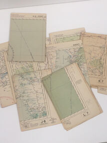
Map - Aeronautical Maps x 9, May 1943
Typical of the maps used during navigation training here at Nhill during WW2Aeronautical maps of Victoria, Printed on light card green text and markingsThird Edition May 1943, Sheet K8, Australian Aeronautical Map, Equatorial scale 1:1000,000map, aeronaughtical map, navigation -
 Port Melbourne Historical & Preservation Society
Education kit - Student Chalkboard, 1970's - 1992
Invented in the 1840's, chalkboards were commonly use for children in primary school education until the 21st century. Oblong green chalkboard on Masonite backing.education - primary schools, state school 1427 nott street -
Whitehorse Historical Society Inc.
Map, Council facilities, c1992
Map of City of Nunawading with parks and facilities marked and indexed.Map of City of Nunawading with parks and facilities marked and indexed.Map of City of Nunawading with parks and facilities marked and indexed.recreation facilities, city of nunawading, maternal and child health centres, senior citizens centres, parks and reserves, libraries, child care -
Bendigo Historical Society Inc.
Map - TOWNSHIP OF KANGAROO FLAT, 27/01/1932
Map: Township of Kangaroo flat, Parish of Sandhurst , County of Bendigo. Parish plan ( number 194 in Map Cupboard 1)map, bendigo, township, kangaroo flat -
Canterbury History Group
Map - Victorian Railways East Camberwell to Laburnum. Diagram No.3' 58, 1/05/1958 12:00:00 AM
Diagram showing proposed signal and interlocking arrangements for the East Camberwell to Laburnam line 1958canterbury, canterbury station, victorian railways, railway lines -
 Wodonga & District Historical Society Inc
Map - Hamilton-Smith Collection Hand Drawn Map of Wodonga c. 1938
The Hamilton-Smith collection was donated by the children of Grace Mary Hamilton-Smith nee Ellwood (1911-2004) and John Hamilton-Smith (1909-1984) who settled in Wodonga in the 1940s. The Ellwood family had lived in north-east Victoria since the late 1800s. Grace’s mother, Rosina Ellwood nee Smale, was the first teacher at Baranduda in 1888, and a foundation member of the C.W.A. Rosina and her husband Mark retired to Wodonga in 1934. Grace and John married at St. David’s Church, Albury in 1941. John was a grazier, and actively involved in Agricultural Societies. The collection contains significant items which reflect the local history of Wodonga, including handmade needlework, books, photographs, a wedding dress, maps, and material relating to the world wars. This item is unique, handmade and has a known owner. It forms part of a significant and representative historical collection which reflects the local history of Wodonga. It contributes to our understanding of social and family life in early twentieth century Wodonga, as well as providing interpretative capacity for themes including local history and social history.A map hand drawn in black pen on thick beige paper. map, subdivison, development, wodonga, local history, hamilton-smith, hamilton-smith collection -
 Whitehorse Historical Society Inc.
Map - Atlas
Hand drawn maps of Europe, United States, North Pacific Ocean, Great Britain, China, Iberia Peninsular.Hand-made atlas in an exercise book. Book is covered by Brown paper.E. J. Harris VIII grade Princess Hill. -
 Federation University Historical Collection
Map, Warragul, 1942, not dated
printed colour mapwarragul -
Whitehorse Historical Society Inc.
Map, Highbury Road, c1970
Enlarged aerial photo of Highbury Park area.Enlarged aerial photo of Highbury Park area.Enlarged aerial photo of Highbury Park area.highbury road, burwood east, gareth drive, burwood east, blackburn road, burwood east, bennett avenue, burwood east, rae street, burwood east, joy street, burwood east, folkestone road, burwood east, burwood east primary school no. 454, aerial photographs -
Whitehorse Historical Society Inc.
Map, Parish of Nunawading, 1892
Map copied from 'Directory maps - parishes and counties' 26 Nov 1892.Map copied from 'Directory maps - parishes and counties' 26 Nov 1892. Lithographed by G.S. Bonne[y]. Map includes roads, railway, stations, names of property owners. 2nd copy 'for copying'.Map copied from 'Directory maps - parishes and counties' 26 Nov 1892. maps, parish of nunawading -
Whitehorse Historical Society Inc.
Map, Mitcham Road, c1970
Enlarged aerial photograph of intersection of Whitehorse and Mitcham Roads, Mitcham. Scale 1 inch : 40 feetEnlarged aerial photograph of intersection of Whitehorse and Mitcham Roads, Mitcham. Scale 1 inch : 40 feetEnlarged aerial photograph of intersection of Whitehorse and Mitcham Roads, Mitcham. Scale 1 inch : 40 feetmitcham road, mitcham, maroondah highway, mitcham, whitehorse road, mitcham, mitcham primary school, no. 2904, mitcham hotel, aerial photographs -
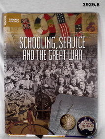 Bendigo Military Museum
Education kit - EDUCATION KIT WW1, Schooling, Service and the Great War, 2015
Schooling, Service and the Great War Primary Resource. See also Cat No 3930..1) Book, soft cover, cardboard with front fold out flap, white print on front & back covers. Illustrated with colour background, group photo of children, embroidery & badges. Inside of cover is a colour photo of timber, leather satchel & papers. 82 cut, plain, white pages. Illustrated black / white / colour photos. Spiral bound, black wire. .2) Poster, paper, Schooling, Service and the Great War. Collage copy of book cover, colour photos. .3) Paper, paper, Australian War Memorial Education Services 2015. Black print, collage colour photos. .4) Poster, paper, Discovering Anzacs. Black print, black / white / colour collage photos. .5) Poster, paper, Anzac Day Schools Award 2015. Black print, black / white photo. .6) Poster, paper, Leadership and Legacy. Yellow print, colour photos. .7) Bookmark, paper, Gallipoli, The First Day. Black print, colour photos. .8) Erratum. Paper, black print for page 30.education, schools, kit ww1 -
Stawell Historical Society Inc
Map, Gampola, County of Borung, 1957
Gampola, County of Borungstawell -
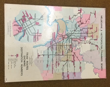 Melbourne Tram Museum
Map, Melbourne & Metropolitan Tramways Board, Del J. Chau, "Tram Routes showing destination numbers", 1972
Full colour map or poster printed on heavy cardboard titled "Tram Routes showing destination numbers". Map dated 1972, showing routes with route numbers, including short working, names of main destinations, roads, railway stations and rail lines, municipalities, rivers, scales, city section in detail, depots and Sunday only services. In bottom right hand corner has number P.14431, Del J. Chau 1972. The original has been altered to show the Bundoora, La Trobe University and East Burwood lines and the change to Airport West. Type of map that was placed on the rear of the driver's doors of a W Class tramcar.trams, tramways, mmtb, map, routes -
Bendigo Historical Society Inc.
Map - CAMPBELL COLLECTION: BENDIGO & DISTRICT MAPS, 21-8-1972
Map. Strathfieldsaye. Locality Plan, Scale 1 inch, also marked are : Shire of Huntly, Shire of McIvor, Shire of Metcalfe, Shire of Maldon, Shire of Marong, City of Bendigo, Lake Eppalock, and various lanes and roads. Mileage on some roads. (number 370 in map cupboard 1)M.Higgsmap, bendigo, rural -
 Wodonga & District Historical Society Inc
Negative - Haeusler Glass Negatives Collection - Ferdinand Haeusler, Maria Klinge, Gottlieb Haeusler, Anna Werner nee Klinge and August Klinge, c1910
The Wodonga Historical Society Haeusler Collection provides invaluable insight into life in late nineteenth and early twentieth century north east Victoria. The collection comprises manuscripts, personal artefacts used by the Haeusler family on their farm in Wodonga, and a set of glass negatives which offer a unique visual snapshot of the domestic and social lives of the Haeusler family and local Wodonga community. The Haeusler family embarked on the “Pauline” from Bremen, Germany in 1846. They lived in South Australia before migrating to the Wodonga West area in Victoria in 1866. Shipping records show the family who left Germany together consisted of William and his wife Johanna Eleanore Klinge nee Schultz and their children Ferdinand, Louise and Gottlieb as well as Johanna Eleanore’s children from her first marriage - Johann Wilhelm Klinge, Johanne Caroline Klinge and Johann August Klinge. Other members of the Haeusler family migrated to South Australia at a later date, settling in South Australia, Victoria and New South Wales. This digital image was produced from one of the glass negatives that form part of the collection, probably taken by Louis Haeusler (b.1887) with the photographic equipment in the Wodonga Historical Society Haeusler Collection.This item is unique and has well documented provenance and a known owner. It forms part of a significant and representative historical collection which reflects the local history of Wodonga. It contributes to our understanding of domestic and family life in early twentieth century Wodonga, as well as providing interpretative capacity for themes including local history and social history.Digital image created from the Haeusler Glass negative collection. A family photo of Ferdinand Haeusler, Maria Klinge, Gottlieb Haeusler, Anna Werner nee Klinge and August Klinge. House in the background would have belonged to either Ferdinand or Gottlieb Haeusler.wodonga pioneers, haeusler family, glass negatives, dry plate photography, klinge family -
 Eltham District Historical Society Inc
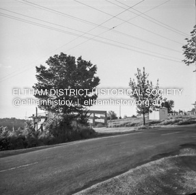
Negative - Photograph, Shire of Eltham, Eltham Meadows Estate, Zig Zag Road subdivision, Jan. 1980
eltham, eltham meadows estate, k.g. mcgorlick pty ltd, mcgorlick real estate, zig zag road subdivision -
 Ballarat Tramway Museum
Negative - Copy, Peter Duckett
Yields information about the use of a maximum traction tram when no longer required for regular passenger use as a "dog car" for transporting owners and their dogs to the Showgrounds for races.Copy negative of a black and white photograph from Ray Pearson Collection, taken by Dave Macartney in 1975c of Melbourne service tram No. 30 - the Dog Car, or Dog tram Camberwell depot, early 1940's. Copy print from Peter Duckett? Used to transport owners and their dogs to the Showgrounds for races, late 1930's and early 1940's. Refer to page 69 of Destination City 5th Edition for the information on this tram and a similar photograph taken by Peter Duckett. Note: Ray Person notes the tram as "No. 20" Image revised from the scan in the Ray Pearson album 30/5/2020. See Page 69 of Destination City 5th Edition and Page 69 of Destination City 5th Edition. trams, tramways, mmtb, bogie trams, dog car, race traffic -
 Marysville & District Historical Society
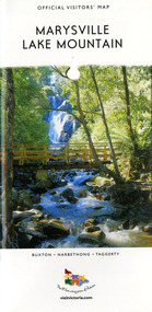
Map (Item) - Tourist map, Mystic Mountains Tourism, OFFICIAL VISITORS' MAP MARYSVILLE LAKE MOUNTAIN, Unknown
A visitors' map of Marysville and Lake Mountain produced by Mystic Mountains Tourism for Visit Victoria.A visitors' map of Marysville and Lake Mountain produced by Mystic Mountains Tourism for Visit Victoria.The Marysville and Lake Mountain Visitor Map and Touring Guide has been compiled and/ published by Mystic Mountains Tourism Inc. Copyright./ Production and artwork Graph Attack P/Lmarysville, lake mountain, victoria, australia, visitor's map, official visitors' map marysville lake mountain, buxton, narbethong, taggerty, visit victoria, mystic mountains tourism inc, graph attack p/l, mystic mountains, marysville triangle, marysville visitor information centre, marylands country house, black spur, steavenson falls, lady talbot drive, cambarville, cathedral ranges, wirreanda festival, lake mountain summit walk, summit walk loop, leadbeaters loop, day loop walk, buxton hotel, igloo roadhouse, karmann waters, silverstream b&b cottages, buxton trout and salmon farm, the niche wine bar, buxton post office & general store, choppers buxton roadhouse, woodlands rainforest bungalows, chestnut glade, black spur inn, wombat cottage, abbey lake luxury b&b spa cottages, mystic mountain ski hire & outdoors, pnl 4wdriving, blue views holiday units & ski hire, marapana agistment park & farm stay b&b, danico design, things of sand & stone, mantirri blueberry farm, allawah country cottages, amberview cottages, ashlar cottage b&b, black spur motel & caravan park, blackwood deluxe cottages, blackwood courtyard b&b, dalrymples guest cottages, delderfield, el kanah guest house, fruit salad farm, kerami guest house, keppels hotel, lake mountain-snow gum lodge, lomatia lodge, lyell guest cottages, magnolia house, keppel waters, lyrebird apartments, marysville caravan park, all view spa apartments, riverside cottages, maryton park b&b country cottages, melina cottage, mountain lodge, mystic mountains holiday cottages, nanda binya lodge, rendezvous luxury cottages, scenic b&b motel, the cumberland, south cathedral farm, tower motel, willowbank at taggerty, woodlands rainforest retreat, marysville & district country club inc, mystic mountains ski hire & outdoors, rubicon valley horse riding, marysville trout and salmon ponds, gallipoli park, keppels lookout, cambarville-yarra ranges national park, lake mountain-yarra ranges national park, lady talbot drive-yarra ranges national park, cathedral range state park, steavenson river, taggerty river, acheron river, lake mountain alpine resort, bruno's art and sculpture garden, manical mechanicals, uncle fred & aunty val's old style lolly shop, carmyle farm boutique, crossways historic country inn, fraga's, gilberts restaurant, heights licensed bistro, the old woolshed cafe, cathedral view natural therapies, crystal journey -
Federation University Historical Collection
Map - Framed image, Public Record Office Victoria, Eureka Treason Trial Map (printed copy), 1855
The persecution produced the original of this map as an exhibit for the Treason Trials of thirteen of the Eureka Stockade in Melbourne in 1855. Witnesses at the time accepted that the map showed the location of the stockade at Ballarat and the route taken by the military and police when the stockade was attacked on 03 December 1854. The original of this work is held by the Public Record Office Victoria.Printed copy of the plan used at the Eureka Treason Trials in 1855.eureka stockade, treason trial map, ballarat, lydiard street north, camp street, paroompi, yarrowee creek -
 Robin Boyd Foundation
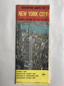
Map, Manhattan Postcard Publishing Co, Souvenir Maps of New York City
Map of New Yorknew york city, map, walsh st library -
 Eltham District Historical Society Inc
Negative - Photograph, J.A. McDonald, Eltham-Yarra Glen Road (Main Road, Eltham), Oct. 1959
The land situated on the northwest corner of Main Road and Brougham Street was originally owned by Justus Jorgensen of Montsalvat. He sold the property and it was purchased for Mobil Service Station (since demolished in the 1990s). This photo was taken by Council in response to a request from the garage proprietor to cut down the trees, presumably based on a claim of visibility. Council's investigation indicated the trees on either corner did not impede visibility which was reported in Council minute 23 Nov 1959.Record of various Shire of Eltham infrastructure works undertaken during the period of 1952-1962 involving bridge and road reconstruction projects, sometimes with Eltham Shire Council Project Reference numbers quoted. It was during this period that a number of significant improvements were made to roads and new bridges constructed within the shire that remain in place as of present day (2022). In many situations, the photos provide a tangible visible record of infrastructure that existed throughout the early days of the Shire. The album was put together by or under the direction of the Shire Engineer, J.A. McDonald.infrastructure, shire of eltham, 1959-11-12, brougham steet, avenue of honour, eltham, main road, mobil service station, trees -
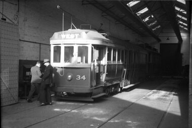 Ballarat Tramway Museum
Negative, Wal Jack, 24/06/1949 12:00:00 AM
Negative and Digital images of the Wal Jack Geelong Negative file of Geelong 34 in the Geelong depot with two men walking away - see Reg Item 5880 for the previous photo. trams, tramways, geelong, depot, tram 34 -
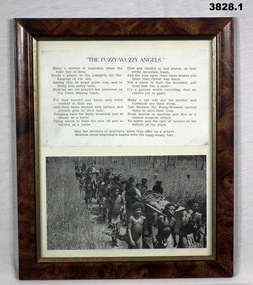 Bendigo Military Museum
Literary work - POEMS, WW1, WW2, FRAMED, C. WW1 and WW2
.1) Poem, The Fuzzy Wuzzy Angels. Top half has black print on white background. Bottom half has black / white photo of Angels carrying the wounded on stretchers. Poem & photo are framed with broken wooden frame, glass front & fawn cardboard backing. .2) Poem, Gallipoli, by St Sgt Sydney BOLITHO 6 Battalion AIF. Written at Gaba Tepe 25.11. 1915. Poem is in black print on white background with black / white photo of S BOLITHO on RHS bottom. Tan wooden frame, glass front, black cardboard backing..1) On rear: 2 white stickers, 1. “2850” 2. “D16” .2) In black texta on rear top of frame: “Tom & Libby Luke”poems, fuzzy wuzzy, galipoli -
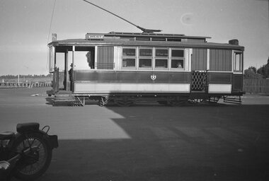 Ballarat Tramway Museum
Negative, Wal Jack
Negative and Digital images of the Wal Jack Geelong Negative file of Geelong car at the Wharf terminus. Tram has the destination of West. Has the waterfront in the background. Based on other photos possibly June 1939. See also Reg Item 7813 for a similar photograph. Maybe the same tram.trams, tramways, geelong, wharf -
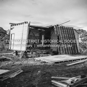 Eltham District Historical Society Inc
Negative - Photograph, J.A. McDonald, Inspection of storm damaged Abraham house at Kangaroo Ground, c. May 1962
Showing the effect of a wind storm that destroyed the house circa May 1962.. The Abraham family owned land near the Aqueduct and east of Nicholas Lane at Kangaroo Ground (based on photos, at or near 40 Nicholas Lane).Record of various Shire of Eltham infrastructure works undertaken during the period of 1952-1962 involving bridge and road reconstruction projects, sometimes with Eltham Shire Council Project Reference numbers quoted. It was during this period that a number of significant improvements were made to roads and new bridges constructed within the shire that remain in place as of present day (2022). In many situations, the photos provide a tangible visible record of infrastructure that existed throughout the early days of the Shire. The album was put together by or under the direction of the Shire Engineer, J.A. McDonald.1962-05, abraham house, kangaroo ground, nicholas lane, property damage, storm damage -
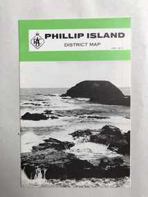 Robin Boyd Foundation
Map, RACV, Phillip Island District Map
walsh st library -
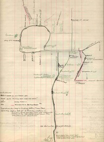 Ballarat Tramway Museum
Map, H.P. James, Ballarat tramway system, 1939
Hand drawn map contained within Reg. Item 2488, page 61 of the Ballarat Tramway system. Note does not show the Drummond St. North line. Shows the loops, horse tram loops, depots, ESCo bus routes, and notes on horse tram loops. Prepared by H.P. James Scan btm2515i2 and 2515i3 show the hand written notes in light pencil. Note Item Not formally Numbered.trams, tramways, map, depot, esco, horse trams, bus routes, ballarat -
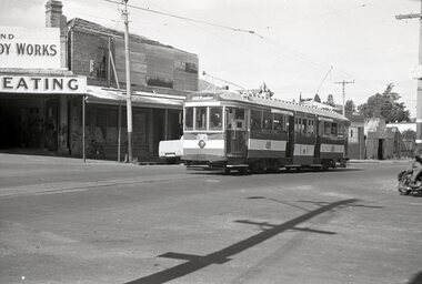 Ballarat Tramway Museum
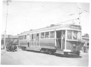
Negative - Royal Tram, 1954 at Humffray St, Wal Jack, 1954
Photograph of No. 38 as the Royal Tram, 1954 at Humffray St. Has a body work repair shop in the background. Tram has the destination of Gardens via Drummond North.Yields information about the tram decorated for the Royal visit in 1954 in Main Road.Negative and Digital images of the Wal Jack Ballarat Negative file.trams, tramways, humffray st, main road, decorated trams, royal visit, tram 38 -
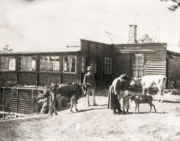 Eltham District Historical Society Inc
Negative - Photograph, Audrey Cahn (nee Osborne) aged two, c.1907-08
Negative copy of an original print and associated print copy of Ethel Osborne photos featuring William Alexander Osborne, Ethel Elizabeth Osborne, Audrey Josephine Osborne, two cows and a calf in front of their home in Warrandyte. Inscribed on reverse of print: WAO EEO Audrey aged 2 Warrandyte 1907-8Negative black and white film 120 6x9 format 2 strips Associated B&W printFuji Safety Neopan SSwarrandyte, audrey cahn, audrey osborne, ethel osborne, houses, william osborne, osborne family, farm animals