-
 Bendigo Historical Society Inc.
Negative - CASTLEMAINE GAS COMPANY COLLECTION: NEGATIVES
Small envelope containing 4 negatives strip relating to photos catalogued from 11518.396 to 11518.404. These negatives have not been scanned.business, retail, gas and fuel -
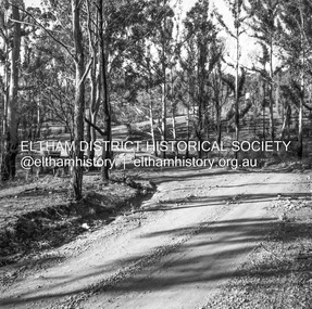 Eltham District Historical Society Inc
Negative - Photograph, J.A. McDonald, Clintons Road, Christmas Hills, 2 July 1962
Looking southwards Temporary bridge on RHS 2 July 1962 The bridge was destroyed by bushfires 15-16 January 1962Record of various Shire of Eltham infrastructure works undertaken during the period of 1952-1962 involving bridge and road reconstruction projects, sometimes with Eltham Shire Council Project Reference numbers quoted. It was during this period that a number of significant improvements were made to roads and new bridges constructed within the shire that remain in place as of present day (2022). In many situations, the photos provide a tangible visible record of infrastructure that existed throughout the early days of the Shire. The album was put together by or under the direction of the Shire Engineer, J.A. McDonald.1962-07-02, bridge construction, christmas hills, clintons road, infrastructure, shire of eltham, victorian bushfires - 1962, bush fires -
Whitehorse Historical Society Inc.
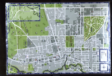
Map, Community, 1/04/1983 12:00:00 AM
City of Nunawading community facilities as at 1/4/1983City of Nunawading community facilities as at 1/4/1983City of Nunawading community facilities as at 1/4/1983city of nunawading, parks & reserves -
Ringwood and District Historical Society
Legal record - Conditions of Sale (C.E.Carter), Ringwood, Lot 117 on Plan of Subdivision 14278, Mr A.J.Treacey and Mr & Mrs Wardley, 1945
Particulars and Conditions of Sale of Property , from Mr A.J.Treacey to Mr & Mrs. Wardley, Register No 14278. -
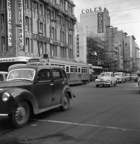 Ballarat Tramway Museum
Negative - Set of 4, Geoff Grant, 24/06/1955 12:00:00 AM
Negatives No. N338 to N341 and black and white prints made by a laser printer (stored in folder ) of the four official commissioning tramcars in Bourke St. 24/6/1955. Trams showing "Special" 1609.1 - tram crossing Swanston St., westbound. Has Leviathan, Odeon Theatre and Coles in the background. 1609.2 - taken from Swanston St. looking up to Parliament house with bus on right side and tram in the distance. Has Tivoli and Esquire Theatres in the background. 1609.3 - W6 986 just after crossing Swanston St with Myers, GPO and Buckley and Nunn's buildings in background. 1609.4 - W6 991 about to cross Swanston St. with Tivoli theatre in background. See Reg Item 3624 for a photo of 986 outside Foys on the same day. Negative scanned hi res and imaged updated 22/5/2020.trams, tramways, melbourne, bourke st, swanston st., commissioning, tram w6 986 tram w6 991 -
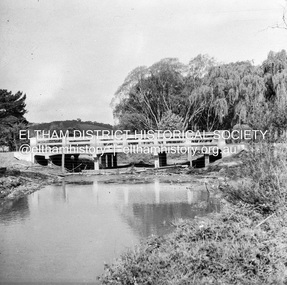 Eltham District Historical Society Inc
Negative - Photograph, J.A. McDonald, Unidentified bridge, c.May 1958
Record of various Shire of Eltham infrastructure works undertaken during the period of 1952-1962 involving bridge and road reconstruction projects, sometimes with Eltham Shire Council Project Reference numbers quoted. It was during this period that a number of significant improvements were made to roads and new bridges constructed within the shire that remain in place as of present day (2022). In many situations, the photos provide a tangible visible record of infrastructure that existed throughout the early days of the Shire. The album was put together by or under the direction of the Shire Engineer, J.A. McDonald.infrastructure, shire of eltham, 1958-05, bridge construction -
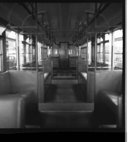 Ballarat Tramway Museum
Negative, Geoff Grant, 19/06/1955 12:00:00 AM
Negative No. N328 and black and white print made by a laser printer (stored in folder ) of the interior of W7 1003 showing the new compartment arrangements - smoking was in the centre section. Photo taken 19/6/1955. Negative scanned hi res and imaged updated 21/5/2020.trams, tramways, mmtb, interiors, smoking, w7 class, tram 1003 -
Whitehorse Historical Society Inc.
Map, M.M.B.W, c1962
Melbourne Metropolitan Area Base Map series sheet 235, covering part, Mitcham, Nunawading and Ringwood areas.Melbourne Metropolitan Area Base Map series sheet 235, covering part, Mitcham, Nunawading and Ringwood areas. Prepared by Department of Lands and Survey and Melbourne and Metropolitan Board of Works from State aerial Survey, June 1957 and Cadastral Survey information, August 1960. Scale 1:4,800.Melbourne Metropolitan Area Base Map series sheet 235, covering part, Mitcham, Nunawading and Ringwood areas. maps, mitcham, nunawading, ringwood, melbourne and metropolitan board of works, victoria. department of lands and survey -
Bendigo Historical Society Inc.
Map - BENDIGO WEST IRRIGATION SETTLEMENT, 13/02/1909
Map: Bendigo West Irrigation Settlement, Parish of Sandhurst, County of Bendigo. Parish plan. ( number 191 in Map Cupboard 1)map, bendigo, irrigation settlement, bendigo west irrigatioon settlement -
Moorabbin Air Museum
Essay (Item) - EP9 Random hand written notes on assortment of items
-
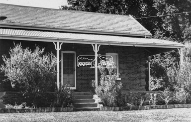 Eltham District Historical Society Inc
Negative - Photograph, Leader Publishing Co, Wingrove Cottage, c.1970
Wingrove Cottage is historically significant for its long association with Charles Wingrove, a prominent figure in Victorian local government, as secretary to the Eltham District Road Board and Shire Council from 1858 to 1904, and Shire Engineer and Secretary to the Heidelberg Road Board. The cottage was also used as the office of the Eltham District Road Board and Council for many years . One of the Shire's oldest dwellings, and one of the few surviving 19th century buildings associated with early Eltham and located in the original Eltham Village Reserve. Wingrove Cottage is considered historically significant to the Shire of Nillumbik and is registered on the Victorian Heritage Database. This photo forms part of a collection of photographs gathered by the Shire of Eltham for their centenary project book,"Pioneers and Painters: 100 years of the Shire of Eltham" by Alan Marshall (1971). The collection of over 500 images is held in partnership between Eltham District Historical Society and Yarra Plenty Regional Library (Eltham Library) and is now formally known as the 'The Shire of Eltham Pioneers Photograph Collection.' It is significant in being the first community sourced collection representing the places and people of the Shire's first one hundred years.Digital image 4 x 5 inch B&W Neg Print 20 x 25 cmsepp, shire of eltham pioneers photograph collection, eltham, wingrove cottage, charles wingrove, houses -
Stawell Historical Society Inc
Map, Great Western, Parish of Concongella, County of Borung, 1958
Great Western, Parish of Concongella, County of Borungstawell -
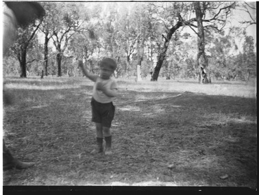 Wodonga & District Historical Society Inc
Negative - Haeusler Glass Negatives Collection - Son of the McKoy Family, c1910
The Wodonga Historical Society Haeusler Collection provides invaluable insight into life in late nineteenth and early twentieth century north east Victoria. The collection comprises manuscripts, personal artefacts used by the Haeusler family on their farm in Wodonga, and a set of glass negatives which offer a unique visual snapshot of the domestic and social lives of the Haeusler family and local Wodonga community. The Haeusler family migrated from Prussia (Germany) to South Australia in the 1840s and 1850s, before purchasing 100 acres of Crown Land made available under the Victorian Lands Act 1862 (also known as ‘Duffy’s Land Act’) in 1866 in what is now Wodonga West. The Haeusler family were one of several German families to migrate from South Australia to Wodonga in the 1860s. This digital image was produced from one of the glass negatives that form part of the collection, probably taken by Louis Haeusler (b.1887) with the photographic equipment in the Wodonga Historical Society Haeusler Collection.This item is unique and has well documented provenance and a known owner. It forms part of a significant and representative historical collection which reflects the local history of Wodonga. It contributes to our understanding of domestic and family life in early twentieth century Wodonga, as well as providing interpretative capacity for themes including local history and social history.Digital image created from the Haeusler Glass negative collection. A small child identified as one of the sons of the McKoy family of Wodonga West, Victoria. C. 1910wodonga pioneers, haeusler family, glass negatives, dry plate photography, mckoy family -
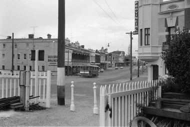 Ballarat Tramway Museum
Negative - Set of 2, Campbell Duncan, 28/02/1971 12:00:00 AM
Yields information about tram operations and the street views at the Ballarat Station area and Lydiard St North.Set of 2 photographs taken on 28/2/1971 by Campbell Duncan of trams at the Ballarat Station level crossing, Lydiard St North.\ .1 - tram - inbound - after with Reid's Palace and the Provincial Hotel in the background. .2 - No. 30 outbound to Lydiard St North with the Ballarat B signal box and the Provincial Hotel in the background. Tram has Bliss bombs tilt tram to read pack advert.trams, tramways, lydiard st north, railway station, level crossings, signals, tram 30 -
Bendigo Historical Society Inc.
Map - PARISH OF SANDHURST SHEET 5A, 1970
Map: Parish of Sandhurst Sheet 5A, County of Bendigo. Parish plan ( number 161 in Map Cupboard 1)map, bendigo, parish plan, parish of sandhurst, county of bendigo -
Beechworth Cemetery Trust
Map - Beechworth Cemetery reproduction of original map -Secretary copy, Beechworth Cemetery
Reproduction map displaying all grave sites in Beechworth Public Cemetery. Rotunda, fountain, nursery, memorial wall, pioneer sectionmap displays the plan of grave sitesLaminated Photocopy of original cemetery map with additional information hand-written on the map. All graves at the cemetery set out in denominational sections with hand-written information on additional graves added to sections in Roman Catholic A & C, Church of England A-F, Presbyterian A-C, Methodist/Uniting B and Wesleyan A. Multidenominational hand-written note on Jews section with Trust Minutes 4.7.'83 written next to this addition. Additions hand-drawn of fountain, memorial wall, nursery and pioneer cemetery.rotunda, fountain, nursery, memorial wall, pioneer section, graves, chinese section, un-numbered grave sites, cemetery -
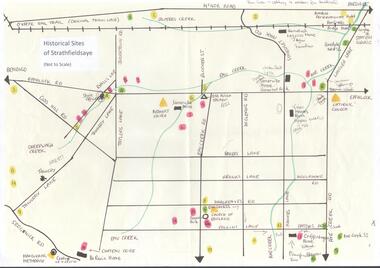 Bendigo Historical Society Inc.
Map - MAP OF HISTORICAL SITES OF STRATHFIELDSAYE
On one side a map of the historical sites of Strathfieldsaye (not to scale) and on the other ten photographs of people and sites and a list of the sites marked on the map.bendigo, history, strathfieldsaye -
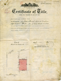 Whitehorse Historical Society Inc.
Legal record - Document, Certificate of Title - Scott, 14/04/1915 12:00:00 AM
Certificate of Title dated 14/4/1915 in the name of Emma Elizabeth Scott.Certificate of Title dated 14/4/1915 in the name of Emma Elizabeth Scott. Land bounded by Victoria Street and Scott Street, MitchamCertificate of Title dated 14/4/1915 in the name of Emma Elizabeth Scott.land titles, scott, emma elizabeth, scott street, mitcham, victoria street -
Glenelg Shire Council Cultural Collection
Literary work - Birthday Poem for Betty Vivian, Charles French, 03/02/1941
Charles French owned a shop on Percy Street in Portland.Poem written for Betty Vivian on her 12th birthday, by Charles French. White lined paper, handwritten in black ink.vivian family records, poem, written word, birthday -
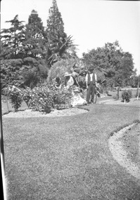 University of Melbourne, Burnley Campus Archives
Negative - Black and white negative, Students Working in the Garden, 1922-1923
Black and white photograph. 4 students working in the Ornamental Garden, one holding a hose.. Note attached, "Student.-...McCormick," may not belong to this photograph.j.l. provan, students working outside, ornamental garden -
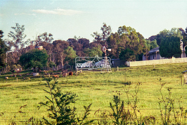 Eltham District Historical Society Inc
Negative - Photograph, Edendale Community Farm, Gastons Road, Eltham, 1998c
Roll of 35mm colour negative film, 8 strips and associated 10 x 15 cm colour printKodak Gold 100-5edendale community farm, eltham, gastons road -
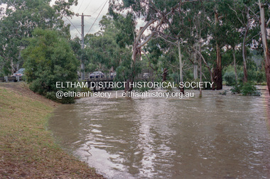 Eltham District Historical Society Inc
Negative - Photograph, Diamond Creek floodwaters near Main Road Bridge, Eltham, Feb. 2005
Flooding of the Diamond Creek in February 2005Roll of 35mm colour negative film, 7 strips Associated colour print 10 x 15 cmKodak GC400-8bridge, diamond creek (creek), eltham, eltham south, floods, main road, main road bridge -
Bendigo Historical Society Inc.
Map - COLBINABBIN, June 1951
Map: Colbinabbin, County of Rodney. Parish planmap, rodney, parish plan, colbinabbin, county of rodney -
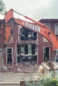 Eltham District Historical Society Inc
Negative - Photograph, Harry Gilham, Demolition of Eltham Shire Offices, 895 Main Road, Eltham, Aug. 1996
The Shire Offices opened in 1965 and were extended in 1971. The final Eltham Shire Council meeting was held in December 1994 before the forced amalgamations of municipal councils by the Kennett Government. The State-Government-appointed Commissioners (1994-1996) took the decision in July 1996 to demolish the Eltham Shire Offices. The demolition works started within 24 hours of the decision being made.Roll of 35mm colour negative film, 5 of 6 strips Associated printKodak Gold 100-5eltham shire office, demolition -
Bendigo Historical Society Inc.
Map - EPPALOCK, COUNTY OF BENDIGO MAP, 3/11/1882
Map: Eppalock, County of Bendigo. Parish plan (number 302 in map cupboard 1)map, bendigo, parish plan, eppalock -
 Federation University Historical Collection
Map, Sebastopol (Delacombe, Redan and Ballarat South) Retail and Business Guide, 2005, 10/2005
Sebasgtopol is a suburb of Ballarat.Sebastopol, Delacombe, Redan and Ballarat South and business guide map.map, guide, delacombe, redan, ballarat south, victorian park, bray raceway, sebastopol equestrian centre, western oval, city oval -
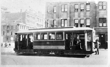 Melbourne Tram Museum
Negative, Wal Jack collection, 1924/25
Black and white copy negative of a photo of MMTB A class No. 10 in Swanston St, c1924/25. Rod Atkins advised 11/10/2020: Confirmed A10 is in Swanston Street at Lonsdale Street facing north. The building behind the tram still stands today on the north west corner together with two large buildings in Lonsdale Street. These two were formerly part of Myer and now form part of The Emporium today. Photo appears in the Ray Pearson album with the above date. Shows the California Combination layout,trams, tramways, a class, swanston st, tram 10 -
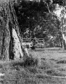 Eltham District Historical Society Inc
Negative - Photograph, Eltham - Wingrove Park, early 1950s
Scar tree in foreground of Wingrove Park, named for Charles Symons Wingrove who was Secretary and Engineer for the Shire of Eltham for almost 50 years This photo forms part of a collection of photographs gathered by the Shire of Eltham for their centenary project book,"Pioneers and Painters: 100 years of the Shire of Eltham" by Alan Marshall (1971). The collection of over 500 images is held in partnership between Eltham District Historical Society and Yarra Plenty Regional Library (Eltham Library) and is now formally known as the 'The Shire of Eltham Pioneers Photograph Collection.' It is significant in being the first community sourced collection representing the places and people of the Shire's first one hundred years.Digital image 4 x 5 inch B&W Negsepp, shire of eltham pioneers photograph collection, eltham, george w bell, main road, wingrove park, tree, scar tree -
Glenelg Shire Council Cultural Collection
Map, Railway Map of Victoria, n.d
Port of Portland CollectionFront: verso - 'Way and Works branch railway Department Melbourne Dec 1954.'port of portland archives, railway, map, 1954, 1950s -
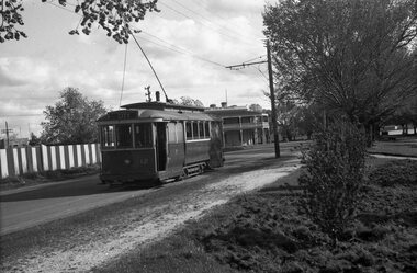 Ballarat Tramway Museum
Negative, Wal Jack, late 1940's
Yields information about Wendouree Parade in the View Point area and the View Point Hotel during the late 1940's.Negative and Digital image of the Wal Jack Ballarat Negative file of No. 12, southbound in Wendouree Parade, near Viewpoint with the Lake View Hotel in the background Tram has the destination of City. trams, tramways, wendouree parade, view point, tram 12