-
 Eltham District Historical Society Inc
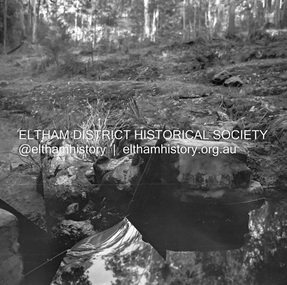
Negative - Photograph, J.A. McDonald, Hurstbridge Water Scheme, 11 May 1961
Weir on Running Creek at Map Ref YAN YEAN 249699 11 May 1961 Reading 8” V http://wikimapia.org/10473910/Running-Creek-ReservoirRecord of various Shire of Eltham infrastructure works undertaken during the period of 1952-1962 involving bridge and road reconstruction projects, sometimes with Eltham Shire Council Project Reference numbers quoted. It was during this period that a number of significant improvements were made to roads and new bridges constructed within the shire that remain in place as of present day (2022). In many situations, the photos provide a tangible visible record of infrastructure that existed throughout the early days of the Shire. The album was put together by or under the direction of the Shire Engineer, J.A. McDonald.infrastructure, road construction, shire of eltham, 1961-05-11, hurstbridge water scheme -
 Bendigo Historical Society Inc.
Map - GOORNONG, Revised 5/06/1926
Map: Town of Goornong, Parish of Goornong, County of Bendigo ( number 153 in Map Cupboard 1)map, bendigo, township, goornong, county of bendigo -
Whitehorse Historical Society Inc.
Map, Municipality of Nunawading, c1950
Plan No 234, compiled and photo-lithographed at the Melbourne and Metropolitan Board of Works under the direction of G.R. McGowan, Chief Surveyor.Plan No 234, compiled and photo-lithographed at the Melbourne and Metropolitan Board of Works under the direction of G.R. McGowan, Chief Surveyor. Covers the area each Side of Canterbury Road from Orchard Grove to Vernon Street. Includes detail of creeks.Plan No 234, compiled and photo-lithographed at the Melbourne and Metropolitan Board of Works under the direction of G.R. McGowan, Chief Surveyor. blackburn south, gardiners creek, blackburn, blackburn creeklands -
Greensborough Historical Society
Map, Greensborough c 1980s, 1980s
Map of Greensborough and surrounds showing bus routes servicing Eltham College.Map of Greensborough and surrounds, black print with colour markings."Bundoora Retirement Village" marked in red pen at E20greensborough - maps, eltham college, bus routes, public transport -
 Robin Boyd Foundation
Map, H M Gousha Company, Chicago
walsh st library -
Bendigo Historical Society Inc.
Map - SANDHURST : COUNTY OF BENDIGO (PART), Circa 1940's
Map: Large scale (2 chains=1') of part of the city of Bendigo. Showing the area from Sommerville St. to Edwards Rd. Flora Hill ( number 195 in Map Cupboard 1)map, bendigo, city streets, bendigo, flora hill, sommerville st. -
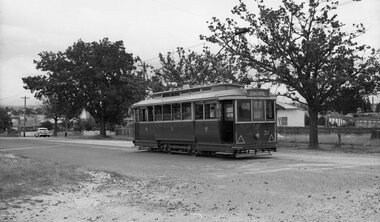
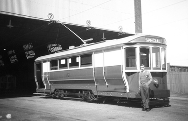 Melbourne Tram Museum
Negative, Wal Jack, 1940's
Black and white negative by Wal Jack of S 161 at the South Melbourne or Hanna St depot. Photo mid 1940's?trams, tramways, hanna st, south melbourne depot, s class, tram 161 -
 National Vietnam Veterans Museum (NVVM)
Map, XA BINH BA (SE), 1967
Paper in map in strip form of Vietnam highlighting in red specific area of interest luscombe Field Nui Dat Overprint Information from RA SVY and Intelligence Sources Nov 67map, vietnam, ra svy -
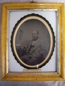 Glenelg Shire Council Cultural Collection
Negative - Ambrotype, Captain Cairncross, c. 1890
On display in History House.Portrait of a man seated next to a table with a tablecloth on it. He is wearing a three-piece suit of a pale shade, and has his left hand at rest on his left thigh, and his right hand on the table. A white hat with a dark band lies on the table. Image has been tinted.Front: (no inscriptions) Back: Captain Cairncorss. This photo came from Windson Cottage. Captain Fawthrop and Captain Cairncross were close friends over many years.(fountain pen, centre). Harry Ward Goldsmith, Late of Portland (green pen, lower centre). -
Whitehorse Historical Society Inc.
Map, Proposed Mitcham Shopping Centre, 1979
Proposed shopping complex of Mitcham.Proposed shopping complex of Mitcham - site plan and ground floor tenancy layout. Four stages of development for this shopping centre by Clarke Hopkins and Clarke Architects included.Proposed shopping complex of Mitcham.mitcham shopping centre, city of nunawading, coles supermarket, mitcham -
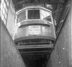 Melbourne Tram Museum
Negative, Wal Larsen, c1950
Black and white negative, of SW6 908 over one of the inspection roads at Essendon depot, c1950. Has the destination of Essendon Depot, dash canopy lighting and a sign "For comfort travel between 9.30 & 4.0" Photo not in Wal Jack Melbourne album. Neg was in a Bright Methodist Church offering envelope - stored with negative file - has 1949 in pencil on the envelope. Wal Larsen was a Bright resident.trams, tramways, sw6 class, dash canopy lights, essendon depot, tram 908 -
Bendigo Historical Society Inc.
Map - FRED COWIE COLLECTION: AERIAL MAPS OF HEATHCOTE/EPPALOCK
Map, Heathcote A3, Aerial Survey of Victoria, Photo-map prepared by Department of Crown Lands.Campaspe River , Wild Duck Creek, Knowsley, Eppalock Weir.Fred Cowie,46 McIvor Rd ,Bendigo.map -
 Bendigo Historical Society Inc.
Negative - TOM PATULLO COLLECTION: DUDLEY HOUSE,BENDIGO
Negative-Printed. Dudley House View Street,Bendigo.cottage, miners, dudley house, bendigo., dudley house, bendigo. -
 Kew Historical Society Inc
Map - Back to Kew 1875, Jesse Dannock, c.1931
The Kew Historical Society has an extensive collection of maps and plans; most relating to the former City of Kew (1860-1994). Within this collection, this hand-drawn map is unique.The most important and earliest original map of Kew in the collection, showing places of interest in early Kew.Hand-coloured map on heavy paper, depicting from Kew in 1875 from memory by Jesse Dannock. The map includes the names of local institutions and old residents. These, and many of the street names are very faded and have been overwritten with biro at a later date.maps - kew (vic), mrs dannock's map, cartography -
 Bendigo Historical Society Inc.
Map - Hustler's Line of Reefs
Longitudinal section of Hustler's Reef & Hustler's Reef no. 1 mine. Plate XX, note plates 4,8,13,20, 26 & 31 form a longitudinal section from Fortuna Hustler's to Hustler's Consols Mine. produced by the underground survey office, Bendigo, September 1913.hustler's reef, bendigo goldfields, hustler's reef no.1 mine -
Whitehorse Historical Society Inc.
Legal record - Document, Account book, 1917 - 1920
Account book 1917 - 1920Account book 1917 - 1920 of Edward Henry Pearce, orchardist and fruit marketer. With explanatory notes on names of fruit and local personalities by Ron Pearce.Account book 1917 - 1920orchards, pearce, edward h, fruit, pearce, ronald harry -
 Ballarat Tramway Museum
Negative, Wal Jack, late 1930's
Yields information about Ballarat 's tram operations and Hospital Corner.Negative and Digital image of the Wal Jack Ballarat Negative file of No. 19 turning from Sturt St into Drummond St North end route to Gardens. In the background are the premises of Shell Petrol, Morris Ellis Motor Engineers, a hair dresser, a bakery, M. George and E Daly and the Great Southern Hotel. Also in the view is the ESCo street electrical pillar. trams, tramways, hospital corner, sturt st, drummond st, tram 19 -
Glenelg Shire Council Cultural Collection
Negative - Glass Plate Negative - Beechwood garden, 1890-1910
Glass plate negative. Image shows three ladies posing in garden at 'Beechwood'. One sitting in chair, one standing and the third sitting on lawn. -
 Eltham District Historical Society Inc
Negative - Photograph, Russell Yeoman, Shire of Eltham War Memorial, Memorial Park, Garden Hill, Eltham-Yarra Glen Road, Kangaroo Ground, c.1980
Shire of Eltham War Memorial Tower at Kangarooo Ground; view from the east and close up of entrance including Honour Roll. On November 11th 1926 the Shire of Eltham War Memorial Tower at Kangaroo Ground was opened. It is regarded as one of Melbourne’s most outstanding lookout towers. It commands a magnificent 360 degree panorama from Kinglake across the Diamond Valley to Macedon and the You Yangs. It is built on a peak which was once a volcano, 237 metres above sea level. After World War one a memorial cairn was erected on the site, and in 1925 a committee of public-minded citizens began to plan for a tower. Many generous donations of material and money were forthcoming so that in 1926 the Governor General Lord Stonehaven was able to unveil the plaque before a crowd of 500 people There was some concern in the 1960s when the Forests Commission wanted to build a firespotters cabin on the top. At first R.S.L. branches opposed the idea, but it was realised that this use could combine with its use as a tourist attraction, and would ensure its maintenance for the future. Today the Kangaroo Ground tower provides one of the best views around Melbourne and is a fitting memorial to those who died in two world wars. From: Historic items for Diamond Valley Community Radio September 1990 (EDHS collection) On November 8th, 1951, the memorial was re-dedicated by the Governor of Victoria, Sir Dallas Brooks with the addition of the names of men from the Shire of Eltham who fell in the Second World War. Further wreaths were added subsequent to this image in time for the 2001 Reembrance Day service to commemorate the men from th shire who had fallen in the Malayan, Korean, Borneo and Vietnam campaigns.Roll of 35mm colour negative film, 2 strips Kodak Safety 5035 Colour print (x1)Kodak Safety 5035garden hill, kangaroo ground, kangaroo ground memorial, memorial park, shire of eltham war memorial, shire of eltham war memorial tower, war memorial, kangaroo ground relief committee -
Bendigo Historical Society Inc.
Map - COSTERFIELD : COUNTY OF BENDIGO, 31-10-12
Map. Costerfield, County of Bendigo, County of Dalhousie, Dargile, Moorambool West, Warrowitue, Heathcote, Town of Costerfield. Photo-Lithographed at the Department of Lands and Survey, Melbourne, by W.J .Butson 31-10-12 price 1/-. (number 93 in map cupboard 1)W.J. Butsonmap, bendigo, costerfield -
 Eltham District Historical Society Inc
Negative - Photograph, Art show, Eltham Community Centre, c.1994
Art show held in the Eltham Community CentreRoll of 35mm colour negative film, 1 stripKodak Gold 100-4art exhibition, eltham community centre -
 Ballarat Tramway Museum
Negative - Set of 2, Campbell Duncan, 10/08/1971 12:00:00 AM
Yields information about tram operations and the street views in the Victoria St and St Alipius churchSet of 2 photographs taken on 10/8/1971 by Campbell Duncan of No. 13 in-bound in Victoria St, passing St Alipius church and School.trams, tramways, victoria st, st alipius, tram 13 -
 Ballarat Tramway Museum
Negative, Wal Jack, late 1940's
Negative and Digital images of the Wal Jack Geelong Negative file of a Geelong turning from Aphasia St into Pakington St. The City of Newtown and Chilwell offices are in the background. Photo late 1940's. trams, tramways, geelong, pakington st, aphasia st -
Bendigo Historical Society Inc.
Map - NERRING SHEET 3, 1/12/1894
Map:Neriing sheet 3. parish plan ( number 188 in Map Cupboard 1)map, bendigo, parish plan, nerring -
Bendigo Historical Society Inc.
Map - YARRAYNE : COUNTY OF BENDIGO, 6-1-32
Map. Yarrayne, County of Bendigo, Janiember East; Pompapiel, Salisbury, Bridgewater, Salisbury West, Powlett. Photo-Lithographed at the Department of Lands and Survey, Melbourne. Price 2/-. 6-1-32. (number 12 in map cupboard 1)H.J. Green, Government Printermap, bendigo, yarrayne -
 Ballarat Tramway Museum
Negative, Wal Jack, late 1950's
Yields information about tram services and the Lydiard St North terminus.Negative and Digital images of the Wal Jack Ballarat Negative file of Ballarat No. 31 at the Lydiard St North terminus late 1950's. Has all the windows open and the blinds up. Tram has the destination of Sebastopol. trams, tramways, lydiard st north, tram 31 -
Charlton RSL Sub Branch
Map - Framed map of Bougainville campaign, Framed campaign map of Bougainville campaign November 1944 to June 1945, showing movements of Brigades and actions
Glass framed map of Bougainville Campaign26th Infantry Battallion -
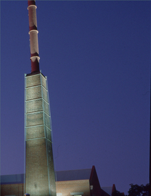 Federation University Historical Collection
Negative - Photograph, Ballarat School of Mines Brewery Building
A building on the Federation University SMB Campus. It is built on the site of the former Ballarat Brewery.2 transparencies of the Brewery building on SMB Campusbrewery building, ballarat school of mines, buildings, chimney -
Whitehorse Historical Society Inc.
Legal record - Land Title, Central Road, 1975
Certificate of Title Vol. 4891 Fol. 97808 to William Elliott Wilson, 2 August 1924, with transfers to 5 May 1975.Certificate of Title Vol. 4891 Fol. 97808 to William Elliott Wilson, 2 August 1924, with transfers to 5 May 1975. With floor plan of house, and letter from National Library of Australia to Mrs L Tetlow re. John Flynn's ownership of the house.Certificate of Title Vol. 4891 Fol. 97808 to William Elliott Wilson, 2 August 1924, with transfers to 5 May 1975. central road blackburn, no. 93, flynn, john, rev. -
Moorabbin Air Museum
Legal record (Item) - Ansett Airways Propriety Limited Certificate Of Registrar General Of Registration Of A Corporation Under The Business Names Act 1928 Part 1 Section 15
Registered No.110000, Under the business name of Air Coach Services.