-
 Kew Historical Society Inc
Plan - Subdivision Plan, Belford Heights Estate, Kew, ca. 1925
Pru Sanderson, in her groundbreaking ‘City of Kew Urban Conservation Study : Volume 2 - Development History’ (1988), summarised the periods of urban development and subdivisions of land in Kew. The periods that she identified included 1845-1880, 1880-1893, 1893-1921, 1921-1933, 1933-1943, and Post-War Development. These periods were selected as they represented periods of rapid growth or decline in urban development. An obvious starting point for Sanderson’s groupings involved population growth and the associated economic cycles. These cycles also highlighted urban expansion onto land that was predominantly rural, although in other cases it represented the decline and breakup of large estates. A number of the plans in the Kew Historical Society’s collection can also be found in other collections, such as those of the State Library of Victoria and the Boroondara Library Service. A number are however unique to the collection.The Kew Historical Society collection includes almost 100 subdivision plans pertaining to suburbs of the City of Melbourne. Most of these are of Kew, Kew East or Studley Park, although a smaller number are plans of Camberwell, Deepdene, Balwyn and Hawthorn. It is believed that the majority of the plans were gifted to the Society by persons connected with the real estate firm - J. R. Mathers and McMillan, 136 Cotham Road, Kew. The Plans in the collection are rarely in pristine form, being working plans on which the agent would write notes and record lots sold and the prices of these. The subdivision plans are historically significant examples of the growth of urban Melbourne from the beginning of the 20th Century up until the 1980s. A number of the plans are double-sided and often include a photograph on the reverse. A number of the latter are by noted photographers such as J.E. Barnes.The Belford Heights Estate was a subdivision in Kew East, even though the title of the plan indicates that it was located in Kew. The subdivision had been approved by 1915, and included 105 lots facing Strathalbyn, Kitchener, Hamilton and Beresford Streets, as well as Balfour and Belford Roads. Those lots hand coloured with red probably represent blocks that had been sold. The additional information provided on the plan is also of interest. The plan includes the original location of East Kew State (Primary) School in Strathalbyn Street, which opened in 1892. The inset Locality Plan also includes the route of the Outer Circle Railway and the location of the Wilsmere and East Kew Stations. The location of the landmark Harp of Erin Hotel is also marked on the Locality Plan.belford heights estate, subdivision plans - kew -
 Eltham District Historical Society Inc
Negative - Photograph, Harry Gilham, Memorial for Pauline Toner, Eltham Cemetery, 1 Aug 2007
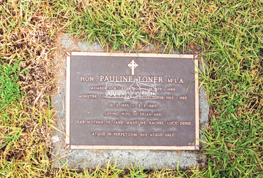
Hon. Pauline Toner M.L.A. Member for Greensborough 1977 - 1989 Minister Community Services Victoria 1982 - 1985 16.3.1935 - 3.3.1989 Loving wife of Brian and Dear mother of Jane, Madeline, Rachel, Lucy, Denis 'Atque in perpetuum. Ave atque vale'eltham cemetery, gravestones, memorials, pauline therese toner -
 Bendigo Historical Society Inc.
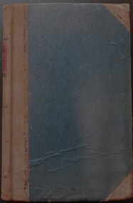
Legal record - Solicitor's Cash book
Local solicitor's cash records Frederick Douglas Jones solicitor's Cash Book No 7 ledger, green hard card covered book with brown leather spine and corners. Ledger covers the period 2 March 1895 to 10 March 1900. Ledger is over 132 pages fully utilised. Frederick Douglas Jones Collectionhandwritten entriesf d jones, solicitor, cash ledger. -
 Ringwood and District Historical Society
Legal record - Conditions of Sale (C.E.Carter), Mitcham - Crown Allotment 124. M.E.Burke to ? Dated June 1st 1929
Particulars and Conditions of Sale of Property , Lot 44 and 45 on Plan of Subdivision 6736, Mitcham Road, Mitcham. Mrs M.E.Burke to ? -
Port Melbourne Historical & Preservation Society
Plan, A J Duncan, Draughtsman, Plans and Sections of Tramsway, May 1891
Plans and typeset descriptions of a proposal to run a cable tram under the Yarra from Williamstown to Melbourne (Falls Bridge) via Port Melbourne. Oriniginally submitted to Victorian Legislative Assembly 1889; this updated 1891 version has 10 pages, and includes an added section to take tramway to Sandridge Road as far as St. Kilda Road. A company has now formed to back the proposal being re-presented to the Legislative Assembly. (Copy of 46.2)Signed by Edward Clark 2-6-1891, with Borough stamp on cover; initialed, ditto, on page 2; signed by A.J. Duncan page 2.transport - tramways, town planning - proposals shelved, williamstown, edward clark, town clerks, mr jennings, austral - anglo tramway and general agency co ltd, a j duncan -
University of Melbourne, Burnley Campus Archives
Plan, Plan of the Zoological and Acclimatisation Society of Victoria, Royal Park, Melbourne, c. 1884
Copy of plan held at the State Library of Victoria surveyed by G. Purchas, possibly 1884. Possibly based on the winning competition entry by Alfred Lynch 1861 (See B17.0076). Also see B18.0030 Plan drawn by Caroline Le Souef.caroline le souef, alfred lynch, zoological and acclimatisation society of victoria, royal park, g. purchas -
 Ballarat Tramway Museum
Negative - Copy, Ray Pearson
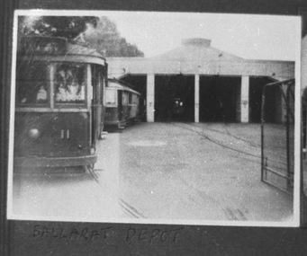
Yields information about the depot area in the late 1930's and the appearance of the tramcars at that time.Copy negative of a black and white photograph from Ray Pearson Collection, taken by Dave Macartney in 1975c of Ballarat No. 11 with 21 behind on No. 1 road, late 1930's. Original negative held in the negative file. Laser print of scanned image in box 01-01-77. Scanned at 2100 dpi and Photoshopped for file image.trams, tramways, secv, depot -
Glen Eira Historical Society
Plan - Warrigal Road, Oakleigh
Documents about a small portion of land on Warrigal Road Oakleigh, now Oakleigh East. A Letter dated 29/05/1952 from Gas and Fuel Corporation of Victoria to Mr. L.P. Simmonds requesting valuation of land for proposed widening of Warrigal Road. A plan of Survey, no.5474, for Crown portion of Parish of Moorabbin and Parish of Mordialloc for owner The Brighton Gas Coy Ltd. New Street Brighton. Mortgages to the National Mutual Life Association. A letter dated 04/06/1952 from Gas and Fuel Corporation of Victoria in reference to Warrigal Road and Centre Road from the Country Roads Board who desire to acquire the land. Handwritten calculation notes and price for valuation, most likely as an attachment to the letter dated 04/06/1952.gas and fuel corporation, warrigal road, centre road, moorabbin council, simmonds l.p, survey plan, county of bourke, the brighton gas company ltd., country roads board, the national mutual life association of australia ltd., bentleigh east -
Port Melbourne Historical & Preservation Society
Plan - Proposed Bayside development, Aug 1987
SCDC plans for the Bayside development were revised as investigations into water circulation in artifical canals/harbour were completed. This is the plan as originally proposed prior to the EES hearing in September 1987.Large plan of original proposed Bayside development as submitted to council in 1987town planning - proposals shelved - bayside, sandridge city development co pty ltd, scdc -
 Eltham District Historical Society Inc
Negative - Photograph, Maroondah Aqueduct Trail, Research, 1991
Roll of 35mm colour negative film, 9 stripsFuji HG 200 CA-1maroondah aqueduct, maroondah aqueduct trail, research (vic.) -
Glenelg Shire Council Cultural Collection
Plan - Line drawing - Port of Portland fishing vessel, n.d
port of portland -
Moorabbin Air Museum
Plan (item) - Beam Installation Untied Technologies Sikorsky Aircraft
Drawing Number :95725-75246 -
 Eltham District Historical Society Inc
Negative - Photograph, Old Lower Plenty Bridge, c.Mar. 1983
Roll of 35mm colour negative film, 4 stripsKodak Safety 5035lower plenty bridge -
University of Melbourne, Burnley Campus Archives
Plan, Arboretum Development Stage 1, 2005
Tracing paper and paper sketches by JK dated 25.07.2005.arboretum, plants -
Glenelg Shire Council Cultural Collection
Negative - Glass Plate Negative - Bentinck Street Portland, 1890-1910
Stereoscopic glass plate negative. (Same as 5771) Man holding 2 bicycles, Bentinck Street south (Cape Nelson Road) looking north from near Must Street. -
Glenelg Shire Council Cultural Collection
Plan - Ship Plan / Mould, n.d
Wooden pattern for mould for boat fitting. Dagger shaped, rounded edges, heart shaped one end, flat underside, holes for attaching to similar piece. Top painted brown, underside painted white. -
Moorabbin Air Museum
Plan (item) - Couguar Turbojet Engine 022-010A - GAF
-
 Melbourne Tram Museum
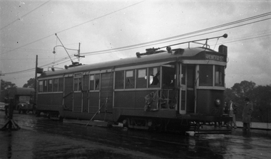
Negative, Wal Jack collection, mid 1920's
Black and White Copy Photograph of Birney X class 217 at the Malvern Depot. Mid 1920'strams, tramways, x class, birney, malvern depot, tram 217 -
 Kew Historical Society Inc
Plan, Melbourne & Metropolitan Board of Works : Borough of Kew : Detail Plan No.1297, 1904
The Melbourne and Metropolitan Board of Works (MMBW) plans were produced from the 1890s to the 1950s. They were crucial to the design and development of Melbourne's sewerage and drainage system. The plans, at a scale of 40 feet to 1 inch (1:480), provide a detailed historical record of Melbourne streetscapes and environmental features. Each plan covers one or two street blocks (roughly six streets), showing details of buildings, including garden layouts and ownership boundaries, and features such as laneways, drains, bridges, parks, municipal boundaries and other prominent landmarks as they existed at the time each plan was produced. (Source: State Library of Victoria)This plan forms part of a large group of MMBW plans and maps that was donated to the Society by the Mr Poulter, City Engineer of the City of Kew in 1989. Within this collection, thirty-five hand-coloured plans, backed with linen, are of statewide significance as they include annotations that provide details of construction materials used in buildings in the first decade of the 20th century as well as additional information about land ownership and usage. The copies in the Public Record Office Victoria and the State Library of Victoria are monochrome versions which do not denote building materials so that the maps in this collection are invaluable and unique tools for researchers and heritage consultants. A number of the plans are not held in the collection of the State Library of Victoria so they have the additional attribute of rarity.Original survey plan, issued by the MMBW to a sewage contractor with responsibility for constructing sewers in the area identified on the plan within the Borough of Kew. The plan was at some stage hand-coloured, possibly by the contractor, but more likely by officers working in the Engineering Department of the Borough and later Town, then City of Kew. The hand-coloured sections of buildings on the plan were used to denote masonry or brick constructions (pink), weatherboard constructions (yellow), and public buildings (grey). This plan of Kew encompasses the area bounded by Barkers Road, High Street and Stevenson Street. Because of the angle created by High Street, a number of houses on the northern side of High Street are shown. The area is dominated by one of the great original landholdings in Kew, described here as the ‘Findon Paddock’. ‘Findon’, the house from which the name of the paddock was taken fronts Stevenson Street and was clearly a rambling structure. The best-known occupant of Findon was Henry ‘Money Miller’ who bought the house in 1871. Miller was a member of Victoria’s first parliament and assisted in the framing of its constitution. Findon was to be subdivided as early as 1912, when the Findon Subdivision was advertised to be sold by auction. In the plan of the subdivision, the original house is not shown, so, presumably it had previously been demolished. Fincham & Son moved the organ, built by Henry Willis, which was installed in the house, first to ‘Whernside’ in Toorak, and later to the Box Hill Methodist Church.melbourne and metropolitan board of works, detail plans, mmbw 1297, cartography, kew (vic.) — municipal collection -
University of Melbourne, Burnley Campus Archives
Plan, VCAH Burnley College - Classroom Locations Map, c.1991
2 copies of plan dated c1991. Buildings named, classrooms numbered.vcah, burnley, classrooms -
Ringwood and District Historical Society
Legal record - Conditions of Sale (C.E.Carter), Ringwood, Lot 10 on Plan of Subdivision (?), Mr V.Geraghty and Mr I.A.Walker, 1946
Particulars and Conditions of Sale of Property , from Mr V.Geraghty to Mr I.A.Walker. -
 Wodonga & District Historical Society Inc
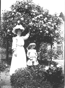
Negative - Haeusler Glass Negatives Collection - Woman and young girl under a flowering bush, c1910
The Wodonga Historical Society Haeusler Collection provides invaluable insight into life in late nineteenth and early twentieth century north east Victoria. The collection comprises manuscripts, personal artefacts used by the Haeusler family on their farm in Wodonga, and a set of glass negatives which offer a unique visual snapshot of the domestic and social lives of the Haeusler family and local Wodonga community. The Haeusler family migrated from Prussia (Germany) to South Australia in the 1840s and 1850s, before purchasing 100 acres of Crown Land made available under the Victorian Lands Act 1862 (also known as ‘Duffy’s Land Act’) in 1866 in what is now Wodonga West. The Haeusler family were one of several German families to migrate from South Australia to Wodonga in the 1860s. This digital image was produced from one of the glass negatives that form part of the collection, probably taken by Louis Haeusler (b.1887) with the photographic equipment in the Wodonga Historical Society Haeusler Collection. This item is unique and has well documented provenance and a known owner. It forms part of a significant and representative historical collection which reflects the local history of Wodonga. It contributes to our understanding of domestic and family life in early twentieth century Wodonga, as well as providing interpretative capacity for themes including local history and social history.Digital image created from the Haeusler Glass negative collection. It depicts an unidentified woman and child standing beneath a flowering bush. A house is partially visible in the background.wodonga pioneers, haeusler family, glass negatives, dry plate photography -
 Eltham District Historical Society Inc
Negative - Photograph, Rose Stereograph Company, The Main Strteet, Eltham, Vic, c.1923
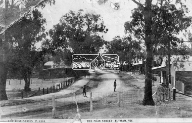
The Rose Series P. 4344 postcard. Similar view to SEPP_0609 taken from near Dudley Street looking north but significantly later in time with numerous stores now constructed on the eastern side south of Pryor Street in what was once Haley's Paddock. Luther Haley sold his bakery store in 1917 and the roof now sports advertising signage for Electrine Candles, presumably coincident with the period of ownership by Hannah Lloyd from 1917 to about February 1920 or Lee’s Railway Store (Messrs J.R. & N.E. Lee 1920-Sep 1922). A boy and a man are standing in the road and the ghost image of three people walking towards them on the footpath just past the store. Ernie Andrew’s combined newsagency and haberdashery/clothing shop with advertising for "The Age" is present at the corner of Arthur Street, on the opposite corner would be the Bootmaker's shop (F. Butterworth, succeeded in 1922 by G.H. McDonald) and William J. Capewell's Butcher shop, second building from right (relocated from in front of the railway station in 1910). North of the News Agency is believed to be Horace H. Clark’s Land and Estate Agency which had also relocated across the road.This photo forms part of a collection of photographs gathered by the Shire of Eltham for their centenary project book,"Pioneers and Painters: 100 years of the Shire of Eltham" by Alan Marshall (1971). The collection of over 500 images is held in partnership between Eltham District Historical Society and Yarra Plenty Regional Library (Eltham Library) and is now formally known as the 'The Shire of Eltham Pioneers Photograph Collection.' It is significant in being the first community sourced collection representing the places and people of the Shire's first one hundred years.Digital image 120 format B&W negative (copy of original postcard)shire of eltham pioneers photograph collection, eltham, main road, bootmakers, butcher, dudley street, electrine candles, eltham town centre, hannah lloyd, lloyd's general store, newsagency, pryor street, rose series postcard, shops, william james capewell, ernie andrew, f. butterworth, g.h. mcdonald, haley's paddock, j.r. lee, lee's railway store, n.e. lee, rose stereograph company -
 Melbourne Tram Museum
Negative, Wal Jack, 24/11/1941 12:00:00 AM
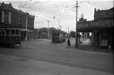
Black and white negative, by Wal Jack, of S 160 (St Georges Road) and W2 455 (West Preston 10) at the intersection of Barkly St and St Georges Road, North Fitzroy. The Trolley Pole is turned on S 160 for the car to return to Lygon St along Holden St. On a wall above the W2 is written "Gone to Berlin" On the corner is a Cash Grocer, advertising McAlpin's Flour, Velvet Soap. In the background is a bus stop sign and housing that has been built since the demolition and sale of the former Cable Tram depot. Photo dated 1-9-1941, in the Wal Jack album.trams, tramways, s class, w2 class, holden st, st georges road, barkly st, route 10, tram 160, tram 455 -
Glenelg Shire Council Cultural Collection
Negative - Negative - panorama of Nelson, Victoria, 1934
Part of a collection of photographs taken by Zillah Maschmedt in 1934. Zillah was a teacher from South Australia.Transparency for black and white photo. Panoramic view of Nelson Viczillah maschmedt, photography, panorama, glenelg river, nelson -
 Melbourne Tram Museum
Legal record, Melbourne & Metropolitan Board of Works (MMBW), "Melbourne and Metropolitan Board of Works - Agree to construction a sewer to Car Barn Preston", 1990 to 1920
Set of our four legal agreements within a set of three brown manila folders: .1 - "Melbourne and Metropolitan Board of Works - Agree to construction a sewer to Car Barn Preston", dated 26/7/1919 with the Fitzroy, Preston and Northcote Tramways Trust - FNPTT, sealed and signed by the Chair, Member and Secretary of the Trust and same for the MMBW. Single sheet, typed both sides with a location drawing. Folder numbered "23". .2 and .3 - "MMBW Sewer Mains - Prahran and Malvern Tramways Trust" - PMTT containing four separate agreements - 20/8/1912, 15/3/1911, 30/4/1909 and 30/5/1914, all folded, sealed and signed documents bound together. Folder number "291 - 292". .4 - ditto with the Melbourne Brunswick Coburg Tramways Trust, MBCTT, dated 23/4/1915 - has various schedules. Folder number "294".trams, tramways, mbctt, fnptt, pmtt, mmbw, construction, depots -
 Ballarat Tramway Museum
Negative, Wal Jack, early 1950's
Negative and Digital images of the Wal Jack Geelong Negative file of Geelong 35 in Ryrie St with the destination of Station followed by No. 22 going to West. A shop in the background is advertising the Geelong Advertiser Newspaper. Possibly late 1940's given the two cars in the view. trams, tramways, geelong, ryrie st, tram 35 tram 22 -
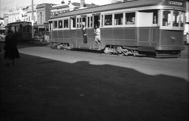
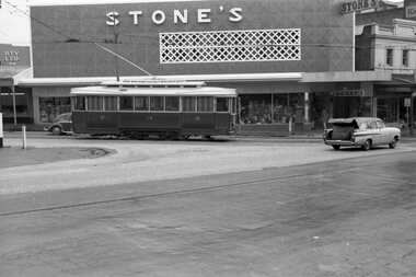 Ballarat Tramway Museum
Negative, Wal Jack, 1950's
Yields information about Ballarat tram No. 18 at Stones Corner.Negative and Digital images of the Wal Jack Ballarat Negative file of No 18 at Stones Corner, in bound from Mt Pleasant. Side on view. Has the Stones clothing store in the background. Note the motor car travelling westbound, with large object in the boot. Has the boot lid open. Photo 1950's. trams, tramways, main road, stones corner, bridge st, tram 30 -
 Eltham District Historical Society Inc
Negative - Photograph, J.A. McDonald, Henley Road at Watsons Creek, Mar. 1961
Henley Road at Watsons Creek Looking easterly along new alignment, 22 March 1961 C. Browns Excavator Contractor Wolf Cr PellingRecord of various Shire of Eltham infrastructure works undertaken during the period of 1952-1962 involving bridge and road reconstruction projects, sometimes with Eltham Shire Council Project Reference numbers quoted. It was during this period that a number of significant improvements were made to roads and new bridges constructed within the shire that remain in place as of present day (2022). In many situations, the photos provide a tangible visible record of infrastructure that existed throughout the early days of the Shire. The album was put together by or under the direction of the Shire Engineer, J.A. McDonald.infrastructure, shire of eltham, 1961-03, bend of islands, cr. charis pelling, henley road, henley road bridge, kangaroo ground, oxley bridge, watsons creek, w.e. wolf, bridge construction, road construction -
 Melbourne Tram Museum
Negative, Wal Jack, c1955
Black and white negative, by Wal Jack, of W2 257 after a collision with a large vehicle. Has part of the front saloon stowed in, footboard and grab handles torn away. Tram has the destination of Spencer St, route 27?. Appears to be in Bridge Road with the river in the background - see also Reg Item 5171 for another photo in Wellington Parade, near Simpson St Photo Wal Jack on a very wet day. Dated 20/4/1951 in the Ray Pearson Album, photographed in Wellington Parade.trams, tramways, w2 class, wellington parade, accidents, route 27, tram 257