-
 Kew Historical Society Inc
Journal, Kewriosity : June 1992
Mountain bikes for Kew Police / p1. Kew Junction Commercial Area Urban Design Options Precincts 1&2 / p1. Responsible dog ownership / p1. Waste Management Strategy / Cr Daryl Oldaker, Malcolm Hutchinson p2&3. Home care for Kew residents / p3. Diary Dates for June/July / p4. Community tree planting day / p5. Friends of Kew Library / p5. Sharps disposal containers/ p5. In Brief [Recycling garden pots; Recycling kerbside collection; Outdated phone books recycled; Kew Pre-school Association; Australian Orthodoxy; Adult literacy classes; Football news; Women at midlife] / p6.Passive smoking - How much does it affect you? / p7. Don't Litter [and fines] / p7. Pictures of Kew [winner of decorated hat exhibition]; Flying start holiday camp [at Carey]; Kew High school teacher and student; James W Waters Award] / p8.Kewriosity was a local newsletter combining Kew Council and community news. It was published between November 1983 and June 1994, replacing an earlier Kewriosity [broad] Sheet (1979-84). In producing Kewriosity, Council aimed to provide a range of interesting and informative articles covering its deliberations and decision making, together with items of general interest and importance to the Kew community and information not generally available through daily media outlets.non-fictionMountain bikes for Kew Police / p1. Kew Junction Commercial Area Urban Design Options Precincts 1&2 / p1. Responsible dog ownership / p1. Waste Management Strategy / Cr Daryl Oldaker, Malcolm Hutchinson p2&3. Home care for Kew residents / p3. Diary Dates for June/July / p4. Community tree planting day / p5. Friends of Kew Library / p5. Sharps disposal containers/ p5. In Brief [Recycling garden pots; Recycling kerbside collection; Outdated phone books recycled; Kew Pre-school Association; Australian Orthodoxy; Adult literacy classes; Football news; Women at midlife] / p6.Passive smoking - How much does it affect you? / p7. Don't Litter [and fines] / p7. Pictures of Kew [winner of decorated hat exhibition]; Flying start holiday camp [at Carey]; Kew High school teacher and student; James W Waters Award] / p8. publications -- city of kew (vic.), kewriosity, council newsletters, community newsletters -
Bendigo Historical Society Inc.
Map - PLAN NEW CHUM LINE OF REEF
Plan showing outcrops of reefs on supposed extension south of the New Chum line of reef from the Eureka extended company's ground. Scale 8 chains to 1 inchplan, bendigo, new chum line of reef -
Bendigo Historical Society Inc.
Map - CAMPBELL COLLECTION: BENDIGO AND DISTRICT MAPS, 2-2-29
Map. Wellsford, Parishes of Wellsford and Axedale, Scale 20 chains to 1 inch. Total area 4994 acres. Prepared in W.P.B. from A and P Plans, by W.J.G.2-2-29. Top left of map are directions to Fosterville, Huntly & Bendigo. (number 361 in map cupboard 1)W.J.Galbraithmap, bendigo, parish plan -
Moorabbin Air Museum
Plan (item) - Albatross Monogram model 1/72 scale assy instructions
-
 Marysville & District Historical Society
Legal record (Item) - Lease Agreement, Law Institute of Victoria, Lease of Real Estate, 2001
A lease agreement for the former premises of the Marysville Opportunity Shop in Victoria.A lease agreement for the former premises of the Marysville Opportunity Shop in Victoria.marysville, victoria, marysville opportunity shop, mops -
 Greensborough Historical Society
Journal, Victoria. Education Department, The School Paper; for Grades V and VI. 1923 and April 1920, 1920_
A collection of stories to enlighten children's minds, prepared by the Victorian Education Department as supplementary reading material.Owned and used by the Partington family, Greensborough pioneers whose children attended Greensborough Primary School.12 issues per schoolyear (incomplete). Black and white illustrations. Front cover missing. Dogeared and damaged edges.On front cover: J.Partington No.2062. Greensborough State School. Inside front cover: a list of articles from the journal.the school paper, reading materials, partington family, education department victoria -
 National Wool Museum
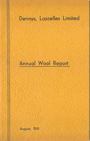
Journal, Dennys, Lascelles Limited Annual Wool Report August, 1961
"Dennys, Lascelles Limited Annual Wool Report August, 1961"Three copies. Yellow paperback stapled booklet entitled "Dennys, Lascelles Limited Annual Wool Report August, 1961" including advice and information for wool growers. 27p.Dennys, Lascelles Limited Annual Wool Report August, 1961wool brokering, wool growing, dennys, lascelles limited -
 Kew Historical Society Inc
Plan, J R Mathers & McMillan, Sackville, Thomas & Lytton Streets, Kew, Twentieth Century
The Kew Historical Society's map collection includes a substantial number of real estate subdivision plans, mainly of Kew but also of surrounding suburbs in Melbourne. Most of the subdivision plans date from the 1920s and 1930s when the districts old homes and local farmland were being split up to accommodate residential growth in the postwar period. These early plans were assembled by a local firm, Jas R Mather & McMillan, which had an office in Cotham Road. Many of the plans, and sometimes photos, were annotated by the agents.Subdivision plans are historically important documents used as evidence for the growth of suburbs in Australia. They frequently provide information about when the land was sold as well as evidence relating to surveyors and real estate and financial agents. The numerous subdivision plans in the Kew Historical Society's collection represent working documents, ranging from the initial sketches made in planning a subdivision to printed plans on which auctioneers or agents listed the prices for which individual lots were sold. In a number of cases, the reverse of a subdivision plan in the collection includes a photograph of a house that was also for sale by the agent. These photographs provide significant heritage information relating house design and decoration, fencing and household gardens.The photograph may also be aesthetically significant depending on the importance of the photographic atelier.Lithographed subdivision plan for an un-named estate with 28 allotments facing Lytton, Sackville and Thomas Streets in Kew. The land would have originally formed part of the Dumaresq Estate. subdivision plans - kew, lytton street, sackville street, thomas street - kew -
Bendigo Historical Society Inc.
Map - HAWKESTONE : COUNTY OF BENDIGO, December 1953
Map. Hawkestone, Parish, County of Bendigo, County of Talbot, Sutton Grange, Redesdale, Faraday, Elphinstone, Metcalfe, Lyell, Coliban River, Myrtla Creek. By Authority W.M. Houston, Government Printer. Drawn and reproduced at the Department of Lands and Survey, Melbourne. December 1953. Price 2/-. (number 99 in map cupboard 1)W.M. Houston, Government Printer.map, bendigo, hawkestone. -
Bendigo Historical Society Inc.
Map - CAMPBELL COLLECTION: BENDIGO AND DISTRICT MAPS, 18-6 29
Map. Longlea, Parishes of Axedale and Eppalock, scale 20 chains to 1 inch, total area 2372 acres. Prepared from Assessment Plan and Parish Plan by H.A. Darby18-6-29., Wondong, Heathcote and Sandhurst line (Railway). (number 386 in map cupboard 1)H.A.Darbymap, bendigo, agricultural lands -
University of Melbourne, Burnley Campus Archives
Plan, 30 Lorne Pde Surrey Hills, c. 1980
Tracing paper copy, "Preliminary Site Plan," by "?N." and a rough sketch on paper. Scale 1:100. Possibly Landscape Design Project 1978.surrey hills, landscape design -
University of Melbourne, Burnley Campus Archives
Map, Map of Showgrounds, c. 1970
Tracing paper plan with grid lines.showgrounds -
 Bendigo Military Museum
Financial record - CHEQUE BOOK, Commonwealth Bank of Australia, c.WWII
Item re Frederick Gardner DAVEY DFC No 410533 RAAF. Refer Reg No 3536P for his service details.Commonwealth Bank of Australia cheque book from the Strand Branch, Australia House, London. Cover is grey card. Each cheque is printed in red ink on cream paper. 5 cheque stubs detail used cheques. Printed in black on cover: 648105 to 648128 In blue ink on cover: CBA Coat of Arms Handwritten in black ink: Details of recipients details issued & amountsbanks, cheques, books -
University of Melbourne, Burnley Campus Archives
Plan, Light Framed Lecture Theatre, 1989-1990
-
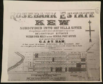 Kew Historical Society Inc
Plan - Subdivision Plan, Rosebank Estate, Kew, 1960-1973
This work forms part of the collection assembled by the historian Dorothy Rogers, that was donated to the Kew Historical Society by her son John Rogers in 2015. The manuscripts, photographs, maps, and documents were sourced by her from both family and local collections or produced as references for her print publications. Many were directly used by Rogers in writing ‘Lovely Old Homes of Kew’ (1961) and 'A History of Kew' (1973), or the numerous articles on local history that she produced for suburban newspapers. Most of the photographs in the collection include detailed annotations in her hand. The Rogers Collection provides a comprehensive insight into the working habits of a historian in the 1960s and 1970s. Together it forms the largest privately-donated collection within the archives of the Kew Historical Society.Rosebank Estate (Kew). A photographic reproduction of a plan in the Vale Collection of the State Library of Victoria made for the historian Dorothy Rogers. This plan is a later version of the original subdivision plan after a number of lots had been sold.rosebank estate (kew), studley park, thomas ham, c.j. & t. ham, rosebank estate, kew, wills street, barry street, fellows street, redmond street, molesworth street, thomas wills, wills family -
University of Melbourne, Burnley Campus Archives
Plan, Power Tool Practical, 1980-1990
Tracing paper and paper copies of plan of where to put bolts and nails in a piece of construction work.tools, construction -
Clunes Museum
Map (item), Dept. of Mines, Untitled, c1859
All maps show names and locations of mines operating in the district (see reference section link to article).1 360 Scale 1:2500 .2 303/59 33 hand written in ink "received 15 October 1859" signed by R Broughton, James Stevenson - District Mining Surveyor .3 40 chains to an Inchgold mining, dept of mines -
 Ballan Shire Historical Society
Map - Map. Shire of Ballan, Shire of Ballan
This is a fairly comprehensive map of the former Shire of Ballan which is now amalgamated into the Shire of Moorabool.A black and white map of the Shire of Ballan showing major roads, rivers, towns, settlements, State parks and forests and land subdivisions. It appears to be a copy of the original as no dates or maker or printer appear on the map. There is a scale of 2 miles to 1 inch.gordon, ballan, bungal, kerrit bareet, borhoneyghurk, bungeeltap, ballark, yaloak, gorong, beremboke, wallace, ingliston, hunterston, millbrook, bradshaw, myrniong, blackwood, moorarbool, greendale, bayup, trentham, bullarto, korweinguboora, glenlyon, bolwarra -
Bendigo Historical Society Inc.
Map - WESTON, 21/10/1876
Map: Re-Survey of part of the parish of Weston, County of Rodney. Parish plan (number 309 in map cupboard 1)Murray and Hargreave, Authorised surveyorsmap, rodney, parish plan, parish of weston, murray and hargreave -
University of Melbourne, Burnley Campus Archives
Plan, Jordan Hansen, David Aldous Turf Memorial Garden Landscape Concept Plan, 2016
Landscape Concept Plan designed by Jordan Hansen for Andrew Smith LCP-001 David Aldous Turf memorial Garden 2016 - page 18. Scale 1:100andrew smith, jordan hansen, landscape design -
Moorabbin Air Museum
Map (Item) - airport maps Includes a tribunal letter about avoiding night flying test, Maps of Australian airports
-
 Kew Historical Society Inc
Plan, Melbourne & Metropolitan Board of Works : Borough of Kew : Detail Plan No.1296, 1904
The Melbourne and Metropolitan Board of Works (MMBW) plans were produced from the 1890s to the 1950s. They were crucial to the design and development of Melbourne's sewerage and drainage system. The plans, at a scale of 40 feet to 1 inch (1:480), provide a detailed historical record of Melbourne streetscapes and environmental features. Each plan covers one or two street blocks (roughly six streets), showing details of buildings, including garden layouts and ownership boundaries, and features such as laneways, drains, bridges, parks, municipal boundaries and other prominent landmarks as they existed at the time each plan was produced. (Source: State Library of Victoria)This plan forms part of a large group of MMBW plans and maps that was donated to the Society by the Mr Poulter, City Engineer of the City of Kew in 1989. Within this collection, thirty-five hand-coloured plans, backed with linen, are of statewide significance as they include annotations that provide details of construction materials used in buildings in the first decade of the 20th century as well as additional information about land ownership and usage. The copies in the Public Record Office Victoria and the State Library of Victoria are monochrome versions which do not denote building materials so that the maps in this collection are invaluable and unique tools for researchers and heritage consultants. A number of the plans are not held in the collection of the State Library of Victoria so they have the additional attribute of rarity.Original survey plan, issued by the MMBW to a contractor with responsibility for constructing sewers in the area identified on the plan within the Borough of Kew. The plan was at some stage hand-coloured, possibly by the contractor, but more likely by officers working in the Engineering Department of the Borough and later Town, then City of Kew. The hand-coloured sections of buildings on the plan were used to denote masonry or brick constructions (pink), weatherboard constructions (yellow), and public buildings (grey). This area was once known as O’Shaughnessy’s Paddock. O’Shaughnessy was the licensee of the Kew Hotel. The ‘Paddock’ or farm was for many years the closest farm to Melbourne. By 1903, when this plan was surveyed and lithographed, little of the farm remained. The area is dominated by a ‘clay hole’, on the site of the current Foley Reserve. It was used by Smart’s Brickyard from the 1880s until 1911, when the Council purchased it for a rubbish dump. It is notable as the site is one of the few industrial operations to have existed in Kew. By 1903, urban development was characterised by larger houses fronting Barkers Road and brick and weatherboard villas in Foley Street. Nearer the pit, weatherboard houses predominated. Foley Street bisected the triangular block and continued right to Denmark Street. At this stage, a house impeded the through road, only allowing access via a right of way to High Street.melbourne and metropolitan board of works, detail plans, mmbw 1296, cartography -
University of Melbourne, Burnley Campus Archives
Plan, Native Garden, 1990-2015
Placement and heights of 6 trees, Burnley Native Garden Area 9/11/90. Placement and heights of 5 trees, Kath Deery Native Garden. Also notes by Geoff Olive made 16.05.2015 from recollections.native garden, kath deery, geoff olive -
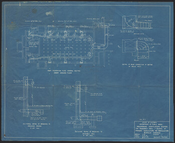 University of Melbourne, Burnley Campus Archives
Plan, K.O. Wood, Mechanical Ventilation System, 1946
Blue print of mechanical ventilation system for Assembly Hall by K.O. Wood, Mechanical Engineer. Dated 9.7.'46.k.o. wood, mechanical engineer, ventilation -
Whitehorse Historical Society Inc.
Map, Elmore Houses, 1/08/1993 12:00:00 AM
Elmore Houses - Blackburn Lake Walk [map by] Ken Green. August 1993.Elmore Houses - Blackburn Lake Walk [map by] Ken Green. August 1993.Elmore Houses - Blackburn Lake Walk [map by] Ken Green. August 1993.blackburn, green, ken, elmore houses, elmore, algernon john -
Glenelg Shire Council Cultural Collection
Financial record - Accounts - Funeral expenses, Mrs E Vivian, 21/03/1928
a. Account from W.A. Jarrett to Mr. W. Vivian, being funeral expenses for his wife, Mrs. E. Vivian, in the sum of £25.3.0. White paper, dark purple print, personal details typed in blue. b. Receipt from W.A. Jarrett to Mr. W. Vivian, for £25.3.0. Printed form, details handwritten, 2d stamp, initialed, dated 21/3/1928, stapled to accountvivian family records, funeral, death, accounts, finance, w a jarrett -
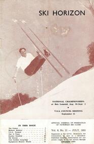 Falls Creek Historical Society
Journal - Ski-Horizon Vol 6 No 11, July 1955
Ski-Horizon is the official journal of the Federation of Victorian Ski Clubs which began publication in 1949. The were 26 original member clubs which included Albury Ski Club, Bogong Ski Club, Myrtleford Ski Club, Tallangatta and District Ski Club and Wangaratta Ski Club. Two pioneers of Falls Creek, Tom Mitchell, M.L.A., and Martin Romuld were Vice-Presidents of the Federation.This Journal is significant because it documents the early development of skiing in Victoria.The journal features stories and events chronicling developments in Victoria and internationally. Items related to the Falls Creek Area in this issue include:- Page 5 - The Falls Creek Village has a wonderful atmosphere. The Nissen Lodge was treated to hectic last minute preparations by the St. Elmos with the assistance of Fred Griffith Outstanding lodges at Falls Creek include St. Trinian's and Bowna.nissen lodge, st. trinian's, bowna ski club -
Ringwood and District Historical Society
Legal record - Conditions of Sale (C.E.Carter), Ringwood - Crown Allotment 27, Harry Peake to ?
Particulars and Conditions of Sale of Property , Harry Peake to ? Dated December 1924. -
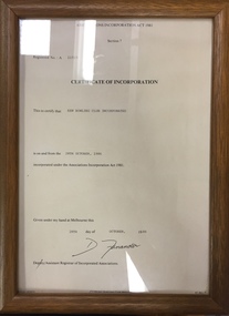 Kew Historical Society Inc
Legal record - Framed Document, Kew Bowling Club Certificate of Incorporation, 1986, 1880
Sports Clubs in Kew in the final decades of the 19th century and in the early 20th century were often umbrella organisations with facilities for a number of sports. Typically in Kew, this included teams in lawn bowls, tennis and croquet. The Kew Bowling Club was formed in 1880 while the privately owned Auburn Heights Recreation Club was opened in 1904. By 1998, the two Clubs decided to amalgamate at the Auburn Heights site in Barkers Road, forming the Kew Heights Sports Club. The combined club was itself taken over by the Melbourne Cricket Club in 2012 becoming MCC Kew Sports Club. In 2017 MCC Kew closed and its landholding was subsequently sold to Carey Baptist Grammar School. Both the Kew and Auburn Heights Clubs assembled important collections. These historically significant and large collections were donated to the Society in 2020. The collections include manuscripts, pictures, trophies, plans, honour boards etc. References Barnard FGA 1910, 'Sports and Pastimes' in Jubilee History of Kew Victoria: Its origin & progress 1803-1910. Nixon NV 1980, The History of the Kew Bowling Club 1880-1980. Reeve S 2012, City of Boroondara: Thematic Environmental History, p.216.The combined collections of the four sporting clubs making up the collection number hundreds of items that are historically significant locally. They are also significant to the sporting history of the greater Melbourne area and to the sports of lawn bowls and tennis in Australia in the 19th and 20th centuries. The collection illuminates two of the Victorian historic themes - 'Building community life' through forming community organisations and 'Shaping cultural and creative life' by participating in sport and recreation.Framed and glazed Certificate of Incorporation of Kew Bowling Club, 1986. [The item is part of the large historic Kew Bowling Club collection (1880-1988) gifted to the Kew Historical Society in 2020].kew bowling club - wellington street - kew (vic), clubs - lawn bowls - kew (vic) -
Bendigo Historical Society Inc.
Map - CITY OF SANDHURST RESURVEY SHEET NO. 3, 13/05/1881
Map: City of Sandhurst Resurvey sheet No. 3. Parish plan.map, bendigo, parish plan, sandhurst, resurvey