-
 Kew Historical Society Inc
Plan, Melbourne & Metropolitan Board of Works : Borough of Kew : Detail Plan No.1581, 1904
The Melbourne and Metropolitan Board of Works (MMBW) plans were produced from the 1890s to the 1950s. They were crucial to the design and development of Melbourne's sewerage and drainage system. The plans, at a scale of 40 feet to 1 inch (1:480), provide a detailed historical record of Melbourne streetscapes and environmental features. Each plan covers one or two street blocks (roughly six streets), showing details of buildings, including garden layouts and ownership boundaries, and features such as laneways, drains, bridges, parks, municipal boundaries and other prominent landmarks as they existed at the time each plan was produced. (Source: State Library of Victoria)This plan forms part of a large group of MMBW plans and maps that was donated to the Society by the Mr Poulter, City Engineer of the City of Kew in 1989. Within this collection, thirty-five hand-coloured plans, backed with linen, are of statewide significance as they include annotations that provide details of construction materials used in buildings in the first decade of the 20th century as well as additional information about land ownership and usage. The copies in the Public Record Office Victoria and the State Library of Victoria are monochrome versions which do not denote building materials so that the maps in this collection are invaluable and unique tools for researchers and heritage consultants. A number of the plans are not held in the collection of the State Library of Victoria so they have the additional attribute of rarity.Original survey plan, issued by the MMBW to a contractor with responsibility for constructing sewers in the area identified on the plan within the Borough of Kew. The plan was at some stage hand-coloured, possibly by the contractor, but more likely by officers working in the Engineering Department of the Borough and later Town, then City of Kew. The hand-coloured sections of buildings on the plan were used to denote masonry or brick constructions (pink), weatherboard constructions (yellow), and public buildings (grey). The streets and built structures in this plan were surveyed in 1903 and released to contractors in 1904. In addition to the designation of building types by colour, the plan includes detailed descriptions of land use and ownership. While many buildings remain from this period, a number of the buildings represented have been demolished including the original Kew Town Hall, and the Congregational and Roman Catholic churches in Walpole Street. While the mansion ‘Illapa’ in Princess Street is still extant – now part of ‘Rylands’ – the neighbouring mansion ‘Elsmere’ was demolished some decades ago. Rivalling Illapa and Elsmere in size were two mansions in Walpole Street, one named on the plan as ‘Gnarlbine’. Over time, Kew Junction and the south side of High Street have been reconfigured and widened, so that the commercial buildings on the corner of Princess and High Street no longer exist. A surprising feature of this part of central Kew to the northwest of Kew Junction is the amount of vacant land. In a number of cases, this land is noted by the contractor as used for vegetable gardens.melbourne and metropolitan board of works, detail plans, maps - borough of kew, mmbw 1581, cartography -
 Ringwood and District Historical Society
Legal record - Conditions of Sale (C.E.Carter), Ringwood, Lot 36 on Plan of Subdivision 11645, Mr H.E.Watson and Mrs F.S.Maggs, 1946
Particulars and Conditions of Sale of Property , from Mr H.E.Watson to Mrs F.S.Maggs, Register No 11645. -
University of Melbourne, Burnley Campus Archives
Plan, A. Lucy, Burnley Gardens Site Works, 1958
Plan showing layout of Gardens bound by Swan St and the Yarra Boulevard. Buildings shown include Fernery, Silo, Residence, Glasshouses, Manure Bins, Store, Milking Sheds, Admin. Building, Laying Sheds, Breeder Shed, Chicken Run, Potting Shed and Plant Research Lab. Also showing proposed paths and kerbing. Public Works Dept., Chief Engineer's Dept. drawn by A. Lucy. Scale 1 in:40 ftgardens, sheds, glasshouses, buildings, a. lucy -
 Kew Historical Society Inc
Plan - Subdivision Plan, J R Mathers & McMillan, Glenferrie Road, Cotham Road, Belmont Avenue, Stirling Street, 1910-1930
Pru Sanderson, in her groundbreaking ‘City of Kew Urban Conservation Study : Volume 2 - Development History’ (1988), summarised the periods of urban development and subdivisions of land in Kew. The periods that she identified included 1845-1880, 1880-1893, 1893-1921, 1921-1933, 1933-1943, and Post-War Development. These periods were selected as they represented periods of rapid growth or decline in urban development. An obvious starting point for Sanderson’s groupings involved population growth and the associated economic cycles. These cycles also highlighted urban expansion onto land that was predominantly rural, although in other cases it represented the decline and breakup of large estates. A number of the plans in the Kew Historical Society’s collection can also be found in other collections, such as those of the State Library of Victoria and the Boroondara Library Service. A number are however unique to the collection.The Kew Historical Society collection includes almost 100 subdivision plans pertaining to suburbs of the City of Melbourne. Most of these are of Kew, Kew East or Studley Park, although a smaller number are plans of Camberwell, Deepdene, Balwyn and Hawthorn. It is believed that the majority of the plans were gifted to the Society by persons connected with the real estate firm - J. R. Mathers and McMillan, 136 Cotham Road, Kew. The Plans in the collection are rarely in pristine form, being working plans on which the agent would write notes and record lots sold and the prices of these. The subdivision plans are historically significant examples of the growth of urban Melbourne from the beginning of the 20th Century up until the 1980s. A number of the plans are double-sided and often include a photograph on the reverse. A number of the latter are by noted photographers such as J.E. Barnes.A ‘proposed’ subdivision of the area in the vicinity of Cotham and Glenferrie Roads and Belmont Avenue depicts an alternate vision for how the land might be divided into lots. When comparing this undated proposed subdivision with a modern map, it is possible to see why the subdivision did not eventuate. The right-of-way shown in the plan as beginning in Belmont Avenue was to be extended much further, preventing the lower lots from being created in the proposed shapes. Identifying the date of the name change may assist in the dating of the proposed subdivision. In faded writing at the top of the plan is an annotation referring to ‘Abbotsford’ and Finlayson’s Agency.subdivision plans - kew, glenferrie road, cotham road, belmont avenue, stirling street -
Glenelg Shire Council Cultural Collection
Financial record - Receipt - purchase of bicycle, 21/02/1900
Receipt from R. Brooks to W. Vivian for the sum of £12.0.0 for a bicycle. Piece of lined paper, handwritten, one penny duty stamp attached.receipt, purchase, bike, bicycle, vivian family records, w vivian -
Moorabbin Air Museum
Plan (item) - Bristol Aeroplane 170 schematic drawings, Replacement of Rear Spar.......rest of title indecipherable
Bristol Aeroplane Company -
Clunes Museum
Plan - PLANS, NEW NORTH CLUNES MINE - UNDERGROUND WORKINGS
.1 HEADER PAGE: "UNDERGROUND WORKINGS - NEW NORTH CLUNES MINE" .2 PLAN .3 PLAN TRANSVERSE SECTIONS .4 PLAN LONGITUDINALSECTIONS.2 "656" PRINTED ON PLAN (FRONT)" .3 PRINTED ON PLAN R-272/.S/1B .4 R-272/S/1Aunderground workings, new north clunes mine -
University of Melbourne, Burnley Campus Archives
Plan - Photocopy, Percy Everett, New School of Primary Agriculture & Horticulture - Burnley Gardens, 1945
Floor plans and elevations of new building designed by Percy Everett, Chief Architect, Public Works DepartmentPhotocopies, reduced in size, of Original Plans for the Administrative Building. Signed, Percy Everett, Chief Architect, Dept of Public Works, Victoria, dated 26.09.1945 (1) UCB.2.135 Ground Floor and First Floor. (2) UCB.2.136 Transverse Section, Longitudinal Section. N.B. University of Melbourne - Property and Services has a better copy.buildings, percy everett -
 Federation University Historical Collection
Plan, Llanberris Co. Transverse Section, not dated
Printed transverse section of the Llanberris Companyunderground survey, llanberris mine, llanberris co, ballarat -
 Federation University Historical Collection
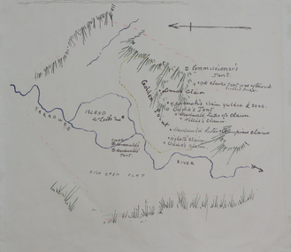
Plan, Dunn's Map of Early Gold Diggers at Golden Point, Ballarat, not dated
Hand drawn map in colour showing Yarrowee River and claims including James Oddie and Highett.dunn, dunn's map, comissioner's tent, oddie's claim, highett's claim, macdonald, suter & co claim, james oddie, golden point, gold discovery -
University of Melbourne, Burnley Campus Archives
Plan - Colour prints, Burnley Low Energy Greenhouse, c. 2008
Laminated plans for greenhouse (1) Burnley Low Energy Greenhouse, (2) Solar Boosted Heat Pump-Greenhouse Bench heating System. Photographs pasted on cardboard and labelled (3) Loading 20mm gravel into Rockpile. (4) Reinforcement at Bottom Gravel level. (5) Sealing the Top of the Rockpile. (6) Top of Rock pile Before A-Frame Construction. (7) Corner Detail of Portal Frame. (8) Glazing Frames for Solar Panels. (9) Structure Partially Clad, with Solar Panel Supports at Rear. (10) Back of Solar Panels in Place. Laminated photographs pated on cardboard and labelled. (11) Burnley Low Energy Greenhouse. (12) Greenhouse Covering Materials Burnley. Panphlet (13) Burnley College Institute of Land and Food Resources (slightly damaged)greenhouse, burnley, low energy greenhouse, solar boosted heat pump, greenhouses, bench heating system, rockpile -
University of Melbourne, Burnley Campus Archives
Plan, Bundoora Extended Care Centre, 1996
South View to Building, Section Elevation by Karin Smith dated 01.06.1996, p3 of 3. Scale 1:50.karin smith, bundoora -
 Flagstaff Hill Maritime Museum and Village
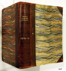
Journal - Women's Journal, Curtis Publication Company, Young Ladies Journal 1884 - 1885, ca. 1884
This is one of two books donated together and believed to have belonged to the Purvis family. The books were rescued from recycling. It has the name of C A. Purvis on the front endpaper. The other book from the same donor has the inscription "C. Purvis". The inscription on the back endpaper of this book is of interest, 'Edith Fox, Gheringhap, 1879' as it is earlier than the earliest journal in the book. Perhaps it is the birth date of Edith. It is also interesting that an notice was printed in the Geelong Advertiser in 1922 stating that Edith Susan Fox of Box Hill had an interest in land in Gheringhap. Gheringhap is a town on the Midland Highway, Victoria, 15 km northwest of Geelong, and 6.7 km southeast of Bannockburn. This is one of two journals of ladies fashion, fancy work and stories that reflect the interests of women the late 1800s. They are a useful source of historical information and include advertising and thought provoking articles .Young Ladies Journal 1884 - 1885; a collection of journals in a burgundy leather-bound spine and hardcovers with a black, blue, burgundy and cram pattern. The Journal contains illustrations and articles of a wide variety including fashion, fancy work and family reading. Inscriptions are on the spine and the front and back end pages. Inserted between pages is a loose Christmas Magazine from The Sun, dated 24th Dec 1954. Published by the Curtis Publication Company, Philadelphia, Pennsylvania, Inside the front cover on the first page, handwritten in pen; "C.A. Purvis 1955" Inscription, script in black ink; "Edith Fox / Gheringhap / 1879"flagstaff hill, flagstaff hill maritime museum and village, warrnambool, maritime museum, maritime village, great ocean road, shipwreck coast, young ladies journal 1884 - 1885, young ladies journal, 1884-1885, ladies journal, women's journal, fashion, fancy work, family reading, illustrated magazine, purvis, c a purvis, edith fox, gheringhap, 1879, edith fox gheringhap 1879 -
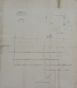
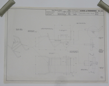 Federation University Historical Collection
Plan - Student's Technical Drawing, Engineering drawing 'Builder's Hand Truck', 1976
Pencil on paper student's technical drawing ballarat school of mines, technical drawing, darryl collins, engineering -
Ringwood and District Historical Society
Legal record - Conditions of Sale (C.E.Carter), Ringwood, Lot 275 on Plan of Subdivision 3051, Mr H.Symes and Mrs E.D.E.E.Melbourne, 1940
Particulars and Conditions of Sale of Property , from Mr H.Symes to Mrs E.D.E.E. Melbourne, Register 3051. -
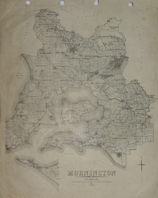 Federation University Historical Collection
Plan, Mornington, 1926
Printed plan on papermornington, phillip island, western port bay, bass straight, wonthaggi, lang lang, sherwood, nepean, narre worran, ringwood -
 Federation University Historical Collection
Plan, Ballarat School of Mines New Classrooms (now Administration Building), 1899
2 copies on paper: .1) Admin buildings .2) Admin buildingsballarat school of mines, new classrooms, administration b, zeek -
Glenelg Shire Council Cultural Collection
Plan - Plan - CRB Bedding pipes, n.d
Port of Portland Authority Archivesport of portland archives -
Ringwood and District Historical Society
Legal record - Conditions of Sale (C.E.Carter), Ringwood , Lot 23 on Plan of Subdivision 3070, Mr L.R.Jones and Mr & Mrs Davidson, 1943
Particulars and Conditions of Sale of Property , from Mr L.R.Jones to Mr & Mrs Davidson, Registration No 3070. -
Glenelg Shire Council Cultural Collection
Legal record - Contract of Sale - Vivian Saddlery Business purchase, 17/05/1912
Contract of sale between Rosina Jones, the vendor and William Vivian, the purchaser, of a saddlery business previously carried out by Mr. J. N. Jones, deceased. Handwritten in black ink on a sheet of ledger paper. Cost of business £41.1.1. Signed by vendor and purchaser, witnessed by Euphemia E. Stevenson, 1d stamp, Victorian stamp duty, dated 17.5.1912 -
Koorie Heritage Trust
Journal - Serials, Beier, Ulli et al, Long water - Aboriginal Art & Literature 1988, 1988
119 P.; ports; notes; ill.; 24 cm.collections - aboriginal, australian, art and literature. -
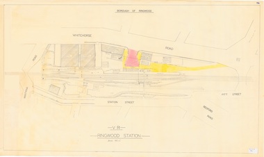 Ringwood and District Historical Society
Plan, Borough of Ringwood - VR Ringwood Station - Circa 1930s
Technical drawing of Ringwood Railway Station features, surrounding streets and buildings including Cool Stores, Packing Shed, Coke Bin, Coal Box, Dam, Garage, Shops, ES&A Bank, Station Master's Residence, Drill Hall, Goods Shed, Signal Box, Passenger Platform, Footbridge, and Clock Tower at Warrandyte Road. Station entrance and traffic access areas shaded red and yellow.Scale: 1"=40' -
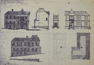
Federation University Historical Collection
Plan, Ballarat Girls' Secondary School, Barkly Street, 1957
ballarat girls secondary school, ballarat east, barkly street -
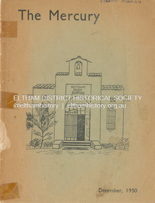 Eltham District Historical Society Inc
Journal - Magazine, Eltham High School, The Mercury, December 1950
1950 was the first edition of The Mercury published by the Eltham High School. 1949 was the last issue of The Mercury as the magazine of the Eltham Higher Elementary School.Inscribed on front cover G. Brown Form 2H Rear cover with multiple autographs1950, eltham high school, eltham higher elementary school, mercury, the mercury -
 Port Melbourne Historical & Preservation Society
Plan - Ship plans, Melbourne Harbor Trust, 1980s
Ship Plans In 2 boxes labelled "Harbour Trust" .01 Flotta Lauro .02 Sea Princess .03 Shaw Saville - Ocean Monarch- MV Akaroa - Mv Arawa - MV Aranda .04 Chandris - Britanis - Queen Frederica .05 Sitmar - TV Fairsky - SS Fairsea - SS Fairwind - Fairstar .06 SS United States - Marco Polo - Monterey- Mariposatransport - shipping, melbourne harbor trust - port of melbourne authority, flotta lauro, sea princess, ocean monarch, shaw savill, p & o, lauro line, britanis, chandris lines, sitmar, fairstar, fairsky, fairwind, marco polo, monterey, mariposa, ss united states, united states line, royal interocan lines, mv tswingi, mv akorda, mv arawa, mv aranda, queen frederica, fairsea -
 Kew Historical Society Inc
Plan, Melbourne & Metropolitan Board of Works : Borough of Kew : Detail Plan No.1561, 1905
The Melbourne and Metropolitan Board of Works (MMBW) plans were produced from the 1890s to the 1950s. They were crucial to the design and development of Melbourne's sewerage and drainage system. The plans, at a scale of 40 feet to 1 inch (1:480), provide a detailed historical record of Melbourne streetscapes and environmental features. Each plan covers one or two street blocks (roughly six streets), showing details of buildings, including garden layouts and ownership boundaries, and features such as laneways, drains, bridges, parks, municipal boundaries and other prominent landmarks as they existed at the time each plan was produced. (Source: State Library of Victoria). This plan forms part of a large group of MMBW plans and maps that was donated to the Society by Mr Poulter, City Engineer of the City of Kew in 1989. Within this collection, thirty-five hand-coloured plans, backed with linen, are of statewide significance as they include annotations that provide details of construction materials used in buildings in the first decade of the 20th century as well as additional information about land ownership and usage. The copies in the Public Record Office Victoria and the State Library of Victoria are monochrome versions which do not denote building materials so that the maps in this collection are invaluable and unique tools for researchers and heritage consultants. A number of the plans are not held in the collection of the State Library of Victoria so they have the additional attribute of rarity.Original survey plan, issued by the MMBW to a contractor with responsibility for constructing sewers in the area identified on the plan within the Borough of Kew. The plan was at some stage hand-coloured, possibly by the contractor, but more likely by officers working in the Engineering Department of the Borough and later Town, then City of Kew. The hand-coloured sections of buildings on the plan were used to denote masonry or brick constructions (pink), weatherboard constructions (yellow), and public buildings (grey). MMBW Detail Plan 1561 outlines those residences in the area bordered by Burke Road, Loxton Street, Mount Street and Barkers Road that had been constructed by 1905 when the land was surveyed. At this time, the area nearest Burke Road had been subdivided and developed whereas the lands to the west were as yet undeveloped. The houses represented are not named on the Plan.melbourne and metropolitan board of works, detail plans, mmbw 1561, cartography -
 Kew Historical Society Inc
Plan - Subdivision Plan, Plan of Subdivision of Part of Crown Portion 84 / Parish of Boroondara / County of Bourke / Lodged Plan No. 2217, Twentieth Century
Pru Sanderson, in her groundbreaking ‘City of Kew Urban Conservation Study : Volume 2 - Development History’ (1988), summarised the periods of urban development and subdivisions of land in Kew. The periods that she identified included 1845-1880, 1880-1893, 1893-1921, 1921-1933, 1933-1943, and Post-War Development. These periods were selected as they represented periods of rapid growth or decline in urban development. An obvious starting point for Sanderson’s groupings involved population growth and the associated economic cycles. These cycles also highlighted urban expansion onto land that was predominantly rural, although in other cases it represented the decline and breakup of large estates. A number of the plans in the Kew Historical Society’s collection can also be found in other collections, such as those of the State Library of Victoria and the Boroondara Library Service. A number are however unique to the collection.The Kew Historical Society collection includes almost 100 subdivision plans pertaining to suburbs of the City of Melbourne. Most of these are of Kew, Kew East or Studley Park, although a smaller number are plans of Camberwell, Deepdene, Balwyn and Hawthorn. It is believed that the majority of the plans were gifted to the Society by persons connected with the real estate firm - J. R. Mathers and McMillan, 136 Cotham Road, Kew. The Plans in the collection are rarely in pristine form, being working plans on which the agent would write notes and record lots sold and the prices of these. The subdivision plans are historically significant examples of the growth of urban Melbourne from the beginning of the 20th Century up until the 1980s. A number of the plans are double-sided and often include a photograph on the reverse. A number of the latter are by noted photographers such as J.E. Barnes.Undated Plan of Subdivision of Crown Portion 84 in what is now Kew. The area shown is bordered by Burke Road, Harp Road, Arglye Road and Normanby Road.subdivision plans -- kew (vic), harp road, burke road, normanby road, lady loch's drive, gladstone street, second avenue, first avenue -
 Kew Historical Society Inc
Plan, Melbourne & Metropolitan Board of Works : Borough of Kew : Detail Plan No.1582, 1904
The Melbourne and Metropolitan Board of Works (MMBW) plans were produced from the 1890s to the 1950s. They were crucial to the design and development of Melbourne's sewerage and drainage system. The plans, at a scale of 40 feet to 1 inch (1:480), provide a detailed historical record of Melbourne streetscapes and environmental features. Each plan covers one or two street blocks (roughly six streets), showing details of buildings, including garden layouts and ownership boundaries, and features such as laneways, drains, bridges, parks, municipal boundaries and other prominent landmarks as they existed at the time each plan was produced. (Source: State Library of Victoria)This plan forms part of a large group of MMBW plans and maps that was donated to the Society by the Mr Poulter, City Engineer of the City of Kew in 1989. Within this collection, thirty-five hand-coloured plans, backed with linen, are of statewide significance as they include annotations that provide details of construction materials used in buildings in the first decade of the 20th century as well as additional information about land ownership and usage. The copies in the Public Record Office Victoria and the State Library of Victoria are monochrome versions which do not denote building materials so that the maps in this collection are invaluable and unique tools for researchers and heritage consultants. A number of the plans are not held in the collection of the State Library of Victoria so they have the additional attribute of rarity.Original survey plan, issued by the MMBW to a contractor with responsibility for constructing sewers in the area identified on the plan within the Borough of Kew. The plan was at some stage hand-coloured, possibly by the contractor, but more likely by officers working in the Engineering Department of the Borough and later Town, then City of Kew. The hand-coloured sections of buildings on the plan were used to denote masonry or brick constructions (pink), weatherboard constructions (yellow), and public buildings (grey). Public buildings, coloured grey on the Plan 1582 include the police station and post office, churches and schools. The earliest church school, Common School No.356 was located at the rear of the Congregational Church in Peel Street. It was constructed in 1859. The first buildings of Kew Primary School No.1075 on the other side of Peel Street were constructed in 1871. The school in 1903 only occupied a small fraction of its current site. In 1903, where the rear playground is now located, were two weatherboard and one brick villa. Trinity Grammar School was founded in 1902 and opened in the Parish Hall at the rear of Holy Trinity Anglican Church. It was not to move to its current site until 1906. The outline of the building housing the Kew Fire Brigade in the centre of the north side of Walton Street is shown but not named on the plan. Further down Pakington Street stood the two-storey Italianate mansion ‘Overton’. The home of Stanford Chapman, it was to be featured in the Imperial Institute series of bromide photographs of Victoria, Vol. 1: Homes and scenery. It was later to become a boarding house before it was later demolished.melbourne and metropolitan board of works, detail plans, maps - borough of kew, mmbw 1582, cartography -
Whitehorse Historical Society Inc.
Journal - Committee Minutes, WHS Minutes
Legal documented minutes of the Nunawading/Whitehorse Historical SocietyCommittee minutes of Historical SocietyThese are the minutes of the Nunawading Historical Society committee meetings held in 2005committee actions and decisions, minutes -
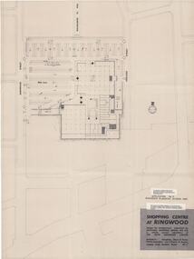 Ringwood and District Historical Society
Plan, Myer Emporium Limited, Planning Application by Eastland Shopping Centre Pty Ltd - Ringwood Planning Scheme 1960. 2 Plans, 1960
One of the plans referred to in the application by Eastland Shopping Centre, a wholly owned subsidiary of the Myer Emporium Limited.|Upper floor plan and lower level traffic plan. Application No 3, Ringwood Planning Scheme 1960.|Architects: Tompkins, Shaw & Evans|Traffic Engineers: Len T Frazer and AssociatesTwo copies of plans for the Ringwood Shopping Centre, comprising; 1. Upper floor plan; 2. Lower level traffic level; Buff coloured heavy paper with black printing. Application No 3, Ringwood Planning Scheme. Shopping Centre at Ringwood design for developmetn submitted by EASTLAND SHOPPING CENTRE PTY.LTD a wholly owned subsidiary of THE MYER EMPORIUM LIMITED Architects: Tomkins, Shaw and Evans Taffic Engineers: Len T. Frazer & Assocs