-
 Ballarat Tramway Museum
Negative, Wal Jack, late 1940s
Negative and Digital images of the Wal Jack Geelong Negative file of Geelong 18 and another car crossing at the Autumn St Loop\ in Pakington St West Geelong. Tram has the destination of West and the other car Station. In the background is Hambrook Milliner and a hotel. Photo possibly late 1940's. trams, tramways, geelong, pakington st, west, tram 18 -
 Melbourne Tram Museum
Negative, Wal Jack, 20-4-1945?
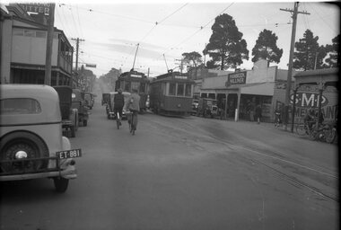
Black and white negative, by Wal Jack, of S 165 in Droop St at White St, with the Footscray Fire Station on the right of the photograph. S 165 has the "Special E" destination indicating it was on an Explosive factory working. In front of the tram is a X1 class. Photo not dated in Wal Jack album, c1943. Could be the same date as Reg Item 5446 - 20-4-1945.trams, tramways, droop st, footscray, world war 2, special e, s class, x1 class, tram 165 -
 Melbourne Tram Museum
Negative, Wal Jack, 13/10/1940 12:00:00 AM
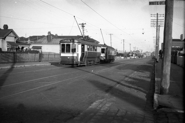
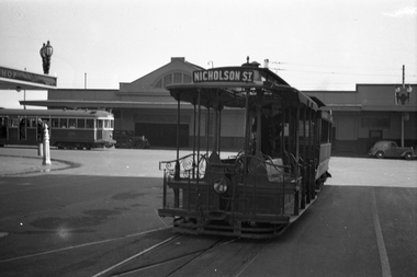
Black and white negative, by Wal Jack, of a cable tram set at the Bourke St terminus. In the background is the Spencer St station buildings and W2 269? northbound in Spencer St. The cable tram has the destination of Nicholson St. See Reg item 5056 for a similar image. Note the street light stand built into the verandah of the hotel and possibly that of Spencer St station verandah.trams, tramways, cable trams, bourke st, spencer st, w2 class, tram 269 -
 Melbourne Tram Museum
Map, Ministry of Transport, "Melbourne Your guide public transport", 1980
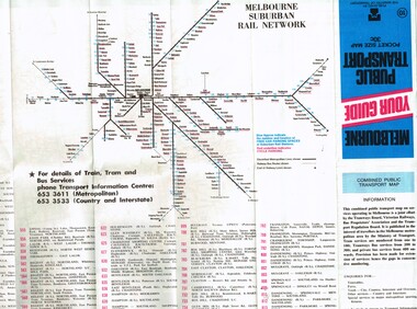
Fold out map (27 sections 9 across x 3 deep), coloured of Melbourne's Tram and Bus routes, route numbers, rail lines, detailed for the central part of Melbourne and insert section for Frankston. On rear description of routes, private bus routes and map of Melbourne metro lines. Has contact details for bookings and lost property etc. Priced 30c No. 11 Dated 1980 on rear .1 - 1 as above, blue cover, No. 10, also dated 1980.trams, tramways, melbourne, map, tram & bus services, railways, mmtb, minister for transport -
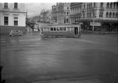 Ballarat Tramway Museum
Negative, Wal Jack, late 1940's or early 1950's
Yields information about the Sturt and Lydiard St intersection and tram services.Negative and Digital image of the Wal Jack Ballarat Negative file of No. 21 turning from Sturt St south side into Lydiard St North. Has the Commonwealth Bank building, National Mutual, and Craig's Hotel. The small newsagent kiosk is in the photo. C. Marks Jewellers in the National Mutual building sign. trams, tramways, sturt st, lydiard st north, tram 23 -
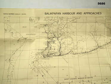 Bendigo Military Museum
Map - MAP, DUTCH BORNEO
Map identified height of land in area and depth of ocean on approached to Balikpapan Harbour. Identified piers, streets and defences and potentially used for landing or combat in the area. MAP PRODUCED BY 2/1 AUST ARMY TOPO SQN CO. Large Yellow paper map with scale of 1:36,000 of Dutch Borneo Balikpapan Harbour and it's approaches. Map folded into 8.balikpapan harbour, maps -
 Whitehorse Historical Society Inc.
Map, Nunawading, 1966
Nunawading's boundaries, schools, topography and railwaysNunawading's boundaries, schools, topography and railwaysNunawading's boundaries, schools, topography and railwaysmaps, city of nunawading, schools -
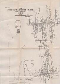 Bendigo Historical Society Inc.
Map - STRUGNELL COLLECTION: UNITED HUSTLER'S & REDAN & K.K.MINES, September 1913
Map, Hustler's Line of Reefs, United Hustler's & Redan & K.K.Mines, Bendigo. Plate No. XXV111 (28),Bulletin 33.Signed H.A.Whitelaw. Drawing seems with their respective mineral contentsUnderground Survey Officemap, bendigo, united hustler's, redan, k.k.mines -
 Bendigo Historical Society Inc.
Map - JACK FLYNN COLLECTION: TARNAGULLA, 13/05/1922
Map: Parish of Tarnagulla . This Item is in very poor condition.By Authority, A. J. Mullen, Government Printer, Melbourne. Lithographed at the Department of Lands and Survey, Melbourne by W. J. Butsonmap, gladstone, parish plan, tarnagulla -
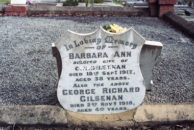 Eltham District Historical Society Inc
Negative - Photograph, Harry Gilham, Grave of Richard Edward Gilsenan and his wife, Harriet Eliza, Eltham Cemetery, Victoria, 1 Aug 2007
Richard Gilsenan was a retired schoolteacher living at “Rosebank” in Eltham, now the site of the Living and Learning Centre. In 1906, Eltham Primary School’s headmaster John Brown died, and Richard was brought out of retirement (briefly) to be acting headmaster. His son Harold was a junior teacher there at the time. Thereafter, Richard was Secretary of the Eltham Progress League and more importantly was a magistrate at the Eltham Court of Petty Sessions. Cases commonly brought before him included not sending a child to school (typical fine 5/- or eight hours in the lock-up), not having a child vaccinated (fixed fine 40/-), stealing fruit from an orchard, selling liquor out of hours, and offensive language and behaviour. Other miscellaneous cases were allowing cattle to wander, selling cigarettes to a minor, carelessly burning off rubbish on a hot windy day, dumping a dead horse in the Diamond Creek, and youths throwing ripe fruit at passers-by. Richard died in 1920 and is buried in Eltham Cemetery with his wife Harriet Eliza. In mourning his passing, his peers noted that his decisions had been given in a very fair way. Incidentally, his son Harold (the teacher) died in 1921 after being trampled by a horse while en route from Eltham to Cathkin (his then school). In Loving Memory Of Richard Edward Gilsenan Died 30th July 1920 Aged 73 years Also Harriet Eliza Beloved wife of above Died 7th Sept. 1933 Aged 78 years Sweet Rest And In Loving Memory Of Barbara Ann Beloved wide of G. R. Gilsenan Died 18th Sept. 1917 Aged 38 years Also the above George Richard Gilsenan Died 2nd Nov. 1918 Aged 40 yearseltham cemetery, gravestones, memorials, barbara ann gilsenan, george richard gilsenan, harriet eliza gilsenan, richard edward gilsenan -
 Bendigo Historical Society Inc.
Map - JACK FLYNN COLLECTION: TARNAGULLA SHEET 4, 25/11/1926
Map: Parish of Tarnagulla Sheet 4, Counties of Gladstone and Bendigo. Parish plan.Photo-Lithographed at the Department of lands and Survey, Melbourne by W. J. Butson. 25.11.26map, gladstone, parish plan, tarnagulla sheet 4 -
Glenelg Shire Council Cultural Collection
Financial record - Cheque Book - Union Bank of Australia Limited, 1926
Used cheque book - The Union Bank of Australia Limited, Portland Free Library stubs dated from May 9 1926 to 22 December 1926, grey card cover.Front: '116' stamp, 4 purple Portland Free Library, Museum & Literary Institute stamps Back: 4 purple stamps, same as frontcheque book, payment, union bank -
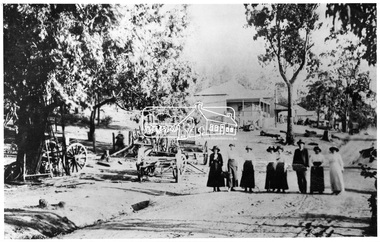 Eltham District Historical Society Inc
Negative - Photograph, Tom Prior, Main Road, Hurstbridge, c.1912
Seven women and one man strolling down Main road, Hurstbridge. They have possibly arrived for a visit on the train, when the railway line was extended from Eltham to Hurstrbridge in 1912. This photo is also contained in the Reynolds-Prior CollectionThis photo forms part of a collection of photographs gathered by the Shire of Eltham for their centenary project book, "Pioneers and Painters: 100 years of the Shire of Eltham" by Alan Marshall (1971). The collection of over 500 images is held in partnership between Eltham District Historical Society and Yarra Plenty Regional Library (Eltham Library) and is now formally known as 'The Shire of Eltham Pioneers Photograph Collection.' It is significant in being the first community sourced collection representing the places and people of the Shire's first one hundred years. The Reynolds family were early settlers in Research. The Reynolds/ Prior collection of photographs were taken by Tom Prior, the maternal uncle of Ivy Reynolds, around 1900 and the 60 photos in the album give a fine overview of many of the landmarks of Research and Eltham over 100 years ago. lvy lived in the family home for many years at 106 Thompson Cres Research. Ivy's father, Ernst Richard Reynolds and grandfather, Richard Reynolds, lived at the same address. Ivy's father Richard worked for Mr. Trail on his property in Research. Reynolds Road is named after the family. Mr Tom Prior (wife Eva) worked at the Melbourne zoo. He was very innovative and made his own camera, using the black cloth hood to exclude the light. The photographs are a reminder of the rural nature of Research and Eltham and its rich heritage.Digital image 4 x 5 inch B&W Negsepp, shire of eltham pioneers photograph collection, hurstbridge, main road, reynolds prior collection -
 Bendigo Historical Society Inc.
Map - JACK FLYNN COLLECTION: BAMAWM, 19/08/1924
Map: Parish of Bamawm, County of Bendigo. Parish plan.Photo Lithographed at the Department of Lands and Survey, Melbourne by W.J. Butson. 19.8.24map, bendigo, parish plan, bamawm -
Bendigo Historical Society Inc.
Map - PORTION OF SANDHURST, 27/01/1877
Map: Hand draughted parish plan, showing a portion of the City of Sandhurst ( number 225 in Map Cupboard 1)map, bendigo, parish plan, sandhurst -
 Ballarat Tramway Museum
Negative - Set of 2, Campbell Duncan, 10/08/1971 12:00:00 AM
Yields information about tram operations and the street views in the Victoria St and St Alipius churchSet of 2 photographs taken on 10/8/1971 by Campbell Duncan of No. 13 in-bound in Victoria St, passing St Alipius church and School.trams, tramways, victoria st, st alipius, tram 13 -
 Ballarat Tramway Museum
Negative, Wal Jack, early 1960's
Yields information about Ballarat tram No. 27 westbound in Sturt St at Lyons St.Negative and Digital images of the Wal Jack Ballarat Negative file of No 27 westbound in Sturt St at the corner of Lyons St. Tram has the destination of Sebastopol, Briquettes and dancing at Civic Hall dash panel adverts. In the background is Ted Moran's boot repair shop, O'Keefe's Music / record shop and a hairdresser. trams, tramways, sturt st, lyons st, tram 27 -
Port Melbourne Historical & Preservation Society
Financial record - PMHPS, Pat Grainger, Annual Report 1998, Aug 1998
PMH&PS was incorporated in 1994, and from 1995 was required to hold an AGM and present an Annual Report. These were compiled, designed, printed on photocopier and bound by the Secretary, except for the Tenth anniversary edition.Annual Report of the PMH&PS, 1998 A5 8 pp plus cover - light brown with photo of 'Sugar Shed'. Contains financial reports, list of members and photo Excelsior Hall.societies clubs unions and other organisations, port melbourne historical & preservation society, pmhps, david thompson -
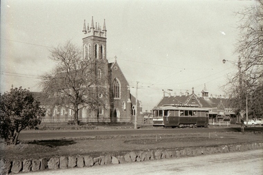
 Melbourne Tram Museum
Negative, c1905
Copy negative of a photograph of cable cars in Swanston, looking north from the Melbourne Town Hall, with horse drawn vehicles and bicycles. c1905.trams, tramways, cable trams, mto co, swanston st, collins st, trailers -
Ringwood and District Historical Society
Legal record - Conditions of Sale (C.E.Carter), Croydon, Lot 8, 9 on Plan of Subdivision 9207, Mr A.Aitkin and Mrs A.Darts, 1942
Particulars and Conditions of Sale of Property , from Mr A.Aitkin to Mrs A.Darts. -
Whitehorse Historical Society Inc.
Map, Sketch map, 1932
Sketch map of Doncaster, Mitcham and Tunstall. Scale 1 inch = 40 chains. 4th issue. 19 Apr 32Sketch map of Doncaster, Mitcham and Tunstall. Scale 1 inch = 40 chains. 4th issue. 19 Apr 32Sketch map of Doncaster, Mitcham and Tunstall. Scale 1 inch = 40 chains. 4th issue. 19 Apr 32maps, doncaster, mitcham, tunstall, nunawading -
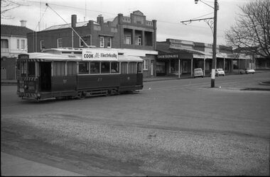
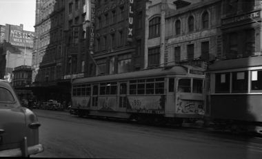 Melbourne Tram Museum
Negative, Wal Jack, 21/07/1951 12:00:00 AM
Black and white negative, by Wal Jack, of SW6 915 decorated for the Golden Jubilee of Australia, on a route 20, Coburg service in Elizabeth St, just before crossing Collins St. Has in the background Muraltune and Andrews stores and adverts for Nestle's and Dulux. Mal Rowe advised 23/8/2020 by e-mail: From the draft text of "The W book": "The first SW6 tram to be decorated was No. 915, which was painted and fitted with panels and aprons promoting fifty years of the Federation of Australia, 1901 to 1951. No. 915 ran on all lines from November, 1950 until May, 1951. In November 1951 No. 915 was fitted with roof illuminations for a six week Christmas promotion. "trams, tramways, decorated trams, elizabeth st, sw6 class, route 20, tram 915 -
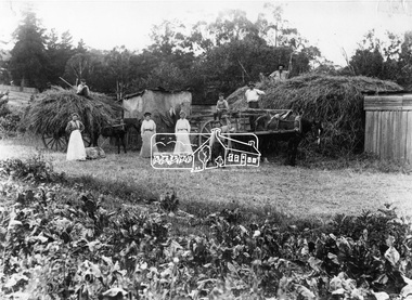 Eltham District Historical Society Inc
Negative - Photograph, Haymaking on the Jarrold property, Eltham, c.1895
Reproduced on p47 of 'Pioneers & Painters' Jarrold family collecting hay on their property, c.1895 The Jarrold property identified by the White Cloud Cottage was at the bottom of the hill on Main Road opposite Dalton Street. The photo was reproduced in the Diamond Valley News c.1987.This photo forms part of a collection of photographs gathered by the Shire of Eltham for their centenary project book,"Pioneers and Painters: 100 years of the Shire of Eltham" by Alan Marshall (1971). The collection of over 500 images is held in partnership between Eltham District Historical Society and Yarra Plenty Regional Library (Eltham Library) and is now formally known as the 'The Shire of Eltham Pioneers Photograph Collection.' It is significant in being the first community sourced collection representing the places and people of the Shire's first one hundred years.Digital image 4 x 5 inch B&W Neg Print 20 x 25 cmshire of eltham pioneers photograph collection, eltham, haymaking, jarrold family, jarrold property, main road, maria street, pioneers and painters -
Whitehorse Historical Society Inc.
Map, Survey for road from Doncaster to Ringwood, 01/03/1867
Survey in County of Bourke, Road Plan no. 390, showing early routes of Doncaster, Whitehorse and Mitcham Roads.Survey in County of Bourke, Road Plan no. 390, showing early routes of Doncaster, Whitehorse and Mitcham Roads. Measurement in chains. Surveyor: Thomas E. Rawlinson.Survey in County of Bourke, Road Plan no. 390, showing early routes of Doncaster, Whitehorse and Mitcham Roads. parish of nunawading, parish of bulleen, whitehorse road mitcham, doncaster road, doncaster east, mitcham road mitcham -
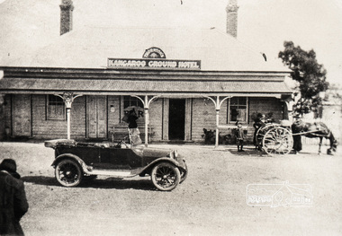 Eltham District Historical Society Inc
Negative - Photograph, Thornton's Kangaroo Ground Hotel, c.1925
Reproduced on p21 of 'Pioneers & Painters' Mrs. R. Thornton notifies that she has taken over the Kangaroo Ground Hotel from Mr. Walker, and the house will be made attractive for weekenders, the table, wines, and spirits being A1 quality" - Advertiser 7 July, 1922" Mrs Ruby C. Thornton sold her interest in the Kangaroo Ground Hotel in September 1928 and moved away after seven years in the district. This photo is therefore dated between July 1922 and 1928. Other newspaper articles identify Mrs Thornton's first name. The lady to the left of frame appears to be taking a photograph of the car in front of the hotel. This may be Mrs Ruby Thornton taking a picture of her car in front of her hotel. A young boy with others standing near their horse and buggy look on.Roll of medium format 120 6x6 black and white negative film, 3 framesAgfa APX 100kangaroo ground, automobile, kangaroo ground hotel, shire of eltham pioneers photograph collection, thornton, ford model t, horse drawn carriage, mrs ruby thornton, pioneers and painters -
Glenelg Shire Council Cultural Collection
Map - Fold-out fire control map - Region 4 Victoria, n.d
Fold-out fire control map for Region 4 - Victoria Northern sheet, includes numerical and alphabetical index. -
Clunes Museum
Financial record - BANK LEDGER
ACCOUNT BOOK OF THE UNION BANK OF AUSTRALIAUNION BANK OF AUSTRALIA LEDGERaccounting ledger, uniion bank of australia -
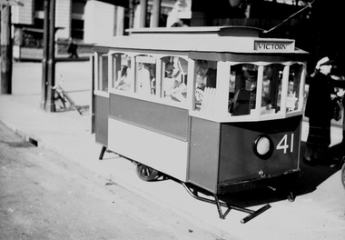 Ballarat Tramway Museum
Negative, Wal Jack, Jul. 1944
Yields information about Ballarat 's Treasure tram and fund raising during the second world war.Negative and Digital image of the Wal Jack Ballarat Negative file of the Treasure Tram built for fund raising by the depot staff to support the Most Popular Conductress Competition. See Reg Items 2129 and 5108 for more details. July 1944. Photographed at the corner of Sturt and Lydiard Streets. Image i1, original scan of the negative, image i2, and adjusted scan. trams, tramways, world war i, most popular conductress competition, conductresses, treasure tram, tram 41 -
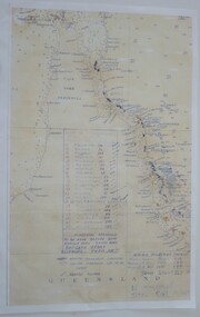 Warrnambool RSL Sub Branch
Map - 1947 Minesweeping map, North Queensland minesweeping map, unknown
1947 an after-effect od WW2Laminated A3 Map plus A4 map in pocket (copies of original)shows location of minefields to be cleared in 1947 and names of minesweeping ships!947 ran history -
Clunes Museum
Map - MAPS, PRODUCED BY CHARLES FENTON, 1987
A MAP OF CLUNES TOWNSHIP - ORIGINAL AND COPY - 1987. ALL STREETS AND BIRCH'S CREEK MARKED WITH ALLOTMENT NUMBERS.CLUNES 1987local history, document, maps, clunes township