-
 Ballarat Tramway Museum
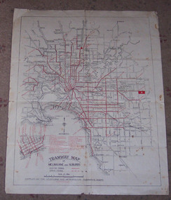
Map, Melbourne and Metropolitan Tramways Board (MMTB), "Tramway Map of Melbourne and Suburbs", 1930c
Two colour map of Melbourne tramway Network, undated, but post the conversion of Collins St to electric trams (late 1929), c1930. Shows both electric and cable lines, various locations, eg the Motordrome, railway lines and primary streets. Compiled by the MMTB.On rear in pencil over three locations "Young Asst Mgr", "Young" and "L Calder? 6 Inglis? Wahroonga"trams, tramways, mmtb, map, cable trams, conversion -
 Glenelg Shire Council Cultural Collection
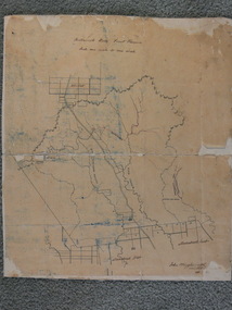
Map - Map - Bridgewater Lakes Tour, 1970s
Typed up directions around the Bridgewater area. Inside: Map of Portland - Bridgewater area.map, tourism, travel, recreation, cape bridgewater -
Whitehorse Historical Society Inc.
Map, Sketch map, 1932
Sketch map of Doncaster, Mitcham and Tunstall. Scale 1 inch = 40 chains. 4th issue. 19 Apr 32Sketch map of Doncaster, Mitcham and Tunstall. Scale 1 inch = 40 chains. 4th issue. 19 Apr 32Sketch map of Doncaster, Mitcham and Tunstall. Scale 1 inch = 40 chains. 4th issue. 19 Apr 32maps, doncaster, mitcham, tunstall, nunawading -
 Ballan Shire Historical Society
Map - Map. Bullarook State Forest, Bullarook State Forest Reserve
A small map of the Bullarook State Forest Reserve. Drawn on a fine buff coloured paper attached to a stiff cloth backing sheet. The title is hand written and includes a "scale one mile to one inch" hand written also. The map is signed "John Wrigglesworth, assistant ? and dated 26/6/1869" although the month and year are almost illegible.moorabool west, state forest, bullarook, eastern moorabool river, werribee river, moorabool east, blakes saw mill, wombat, andersons saw mill -
Whitehorse Historical Society Inc.
Legal record - Land Title, Musk Street, Blackburn
Land Titles referring to No. 1 Musk Street, BlackburnLand Titles referring to No. 1 Musk Street, Blackburn : 1. Vol. 542 Fol. 108222, James William Barnes, 1872; 2. Vol. 1877, Fol. 375367, Freehold Investment and Banking Company of Australia Limited, 1886; 3. Transfer 1507851 to John Thomas Williams, 1932; 4. Vol. 8109 Fol. 997 William Henry Rogers, 1955, with Plan of Subdivision CP 21670; 5. cadastral map, AMA zone 55, Sep 2000.Land Titles referring to No. 1 Musk Street, Blackburn musk street, blackburn, no. 1, maple street, blackburn, lawson street, blackburn, elder street, blackburn, barnes, james william, freehold investment and banking company of australia ltd, springfield road, blackburn, whitehorse road, blackburn, barnes estate -
Stawell Historical Society Inc
Map, Bulgana, Counties of Borung & Ripon, 1959
Bulgana, Counties of Borung & Riponstawell -
Whitehorse Historical Society Inc.
Map, Plan of special survey selected by H. Elgar Esq, 1841
Photocopy of plan and listing of corner stakes.Photocopy of plan and listing of corner stakes. Note on verso: Plan of special survey selected by H. Elgar Esq in the Parishes of Boroondara and Nunawading, County of Bourke. Surveyed by T.H. Nott (?Sydney) 31 May 1841. Boroondara Special Survey B.17, with attached descriptive note by T. H. Nott.Photocopy of plan and listing of corner stakes. maps, parish of boroondara, parish of nunawading, elgar, h, nott, t.h. -
Port Melbourne Historical & Preservation Society
Legal record - Contract - South Melbourne Gas Company, Street Lighting, Sandridge, 8 Jun 1876
Contract from the South Melbourne Gas Company for lighting street lamps in Sandridge 1876.Metropolitan Gas company seal also on contractutilities - gas, south melbourne gas & coke company -
 Federation University Historical Collection
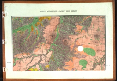
Map, Clunes, Mt Greenock, and Talbot Gold Fields, 1883
A geological plan of the Clunes, Mt Greenock, and Talbot Gold Fields in two parts. .1) This section of the map includes Talbot, Talbot water supply race, Mt Glasgow, Little Green Hill, Middle Hill, Mt Cameron, Ballarat Hill, Bakery Hill, Goodwoman Hill, Scandanavian Lead, Eglinton Swamp, McCallum's Creek, Tullaroop Creek, Dunach, Maryborough Railway, Middle Creek and includes many mines such as Rip Van Winkel, Union Extended, South Greenock, Nicholl's Freehold. .2) This section of the map includes McCallums, Clunes, Green Hill, Mt Beckworth, Mt Gap, Maryborough Reservoir, and includes mines such as Lothair, Bute, Clyde, Clunes Consols, London and Australian, Oriental,clunes, talbot, water supply, railway, geology -
Moorabbin Air Museum
Map (item) - Map Gippsland
-
 Mission to Seafarers Victoria
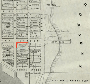
Map, Surveyor General's Office, Plan of Williamstown, County of Bourke, 20 November 1855
Plan of Williamstown in 1855The map helps locate the Wesleyan church on Ann Street which was converted in the Sailors' Rest in 1875.ann street, wesleyan church, sailors' rest, williamstown -
Canterbury History Group
Map - Township of Canterbury and Township of Balwyn, 1900
Copies of the maps of Canterbuy and Balwyn copied and enlarged from Sands and Mcdougall Directory 1900canterbury, balwyn, sands and mcdougall directories -
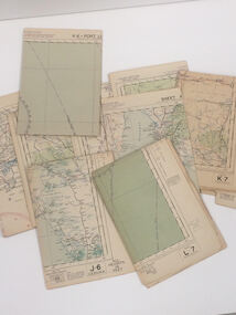 Nhill Aviation Heritage Centre
Map - Aeronautical Maps x 9, May 1943
Typical of the maps used during navigation training here at Nhill during WW2Aeronautical maps of Victoria, Printed on light card green text and markingsThird Edition May 1943, Sheet K8, Australian Aeronautical Map, Equatorial scale 1:1000,000map, aeronaughtical map, navigation -
Stawell Historical Society Inc
Map, T.F. McGauran, William Couty of Borong 1891, 1891
Stawell Water Supply Reserve. Grampians State Forest. Dairy Creek, Fyans Creek, Barney's Creek, Bovine Creek, Glasstree Creek, Stoney Creek. Stawell Water Supply Aquaduct Fkuming Tunnel.A2 Parish Map of Willam Inculdin Stawell Water Supply Reserve and Creeks. Marked in redPhoto Lithographed at the Department of Lands and Survey Melbourne. By T.F. McGauran 20.07.91 water supply survey -
Stawell Historical Society Inc
Map, Mokepilly, County of Borung, Shire of Stawell, 1957
Mokepilly, County of Borung, Shire of Stawellstawell -
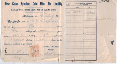 Bendigo Historical Society Inc.
Financial record - Mining documents, 1940-47
The New Chum Syncline Mine was in Happy Valley Road, West BendigoRobinson Fairbairn Collection: New Chum Syncline Gold Mine Shares - 18 in total - all representing 100 shares signed by the Manager Frank Cooper, one of these has a duty stamp attached. New Chum Syncline Gold Mine Forfeiture Notice - for nonpayment of the June Calls in the Golden Sovereign Mine and the New Chum Syncline Gold Mine New Chum Syncline Gold Mine Letter to Shareholder Mrs. S.M. Hosking, acknowledgement of payment for the No 88 Call in the New Chum Syncline Mine, and also to confirm a change of address.history, mining, robinson fairbairn collection, shares, bendigo, new chum syncline mine, golden sovereign mine -
Stawell Historical Society Inc
Map, Whitehead's Map of Victoria, with Alphabetical Key, 1869
Whitehead's Map of Victoria, with Alphabetical Keystawell -
University of Melbourne, Burnley Campus Archives
Map, Map of Showgrounds, c. 1970
Tracing paper plan with grid lines.showgrounds -
Clunes Museum
Financial record - LEDGER
FOUND IN LAURA HUDSON HOUSE, FRASER STREET, CLUNES.1 X LEDGER ENTERED BY JAMES GAMBLE IN 1877 - THE ACCIDENT RELIEF FUND NOVEMBER 17TH.YANKEE TUNNEL TRIBUTE CO. 1877mining records, benevolent fund -
Ringwood and District Historical Society
Legal record - Conditions of Sale (C.E.Carter), Doncaster, Lot (?) on Plan of Subdivision (?), Mr K.M.Matheson and Mrs L.O.Foster, 1944
Particulars and Conditions of Sale of Property , from Mr K.M.Matheson to Mrs L.O.Foster. -
Port Melbourne Historical & Preservation Society
Financial record - Order, J E Earl Timber and Hardware, Customers and staff of J E Earl, Sep 1922
Found under floorboards when building demolished, April 1999. Reason for storage under floorboards unknown; found by 'bottle diggers' and sold to Peter Libbis of the Society in April of 1999Packet of 57 medium sized papers from collection of orders for goods from J.E. Earl, September 1922, handwritten on various bits of paper from scraps to company order forms. Yes!business and traders - timber, built environment, j e earl pty ltd, wormald brothers pty ltd, swallow & ariell ltd, o t box factory, a t harman & sons pty ltd, robert harper & co ltd, a e wearne & son, w c cone & co, joshua brothers distillery -
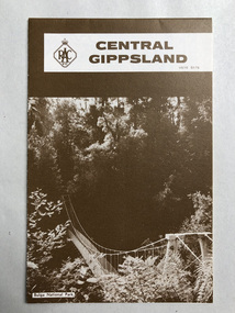 Robin Boyd Foundation
Map, RACV, Central Gippsland
walsh st library -
Port Melbourne Historical & Preservation Society
Financial record - PMHPS, Pat Grainger, Annual Report 2001, Aug 2001
PMH&PS was incorporated in 1994, and from 1995 was required to hold an AGM and present an Annual Report. These were compiled, designed, printed on photocopier and bound by the Secretary, except for the Tenth anniversary edition.Annual Report of the PMH&PS, 2001 A5 8 pp plus cover - peach colour with Phillip Williams montage of Port buildings. Contains financial reports, list of members and photos from Back to Port.societies clubs unions and other organisations, port melbourne historical & preservation society, pmhps, phillip williams, ted kobelt, jim power, ron stranks -
Moorabbin Air Museum
Financial record (Item) - Ansett Motors Ltd Eleventh Annual Report Balance Sheet And Profit And Loss Accounts For The Year Ended 30.06.1947
-
Federation University Historical Collection
Map, Map of Vitilevu showing vehicular roads, native tracks, villages, provinces, 1935
Printed map on paper backed onto linen with small inset maps of Nandi and Singatoka map, vitilevu, singatoka, nandi -
Port Melbourne Historical & Preservation Society
Financial record - PMHPS, Pat Grainger, Annual Report 1997, Aug 1997
PMH&PS was incorporated in 1994, and from 1995 was required to hold an AGM and present an Annual Report. These were compiled, designed, printed on photocopier and bound by the Secretary, except for the Tenth anniversary edition.Annual Report of the PMH&PS, 1997 A5 8 pp plus cover - light brown with all over pattern of Port Melbourne names. Contains financial reports and list of members.societies clubs unions and other organisations, port melbourne historical & preservation society, pmhps, glen cosham -
Federation University Historical Collection
Map, Aboriginal Language Areas in Victoria: A Reconstruction
A4 sized map of Victoria showing Aboriginal Langauge Areas. Black, white and red writing aboriginal, aboriginal language, victoria, djadja wurrung, woi wurrung, watha wurrung, gadubanud, girai wurrung, dhauwurd wurrung, djab wurrung, wiradjuri, tatungalung, wadiwadi, dadidadi, yuyu -
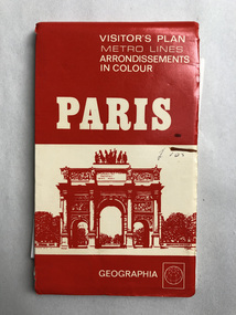 Robin Boyd Foundation
Map, Geographia, Paris
Includes page in PB hand "paris Walk" on reverse. Walks suggested by ken Voss-Smithwalsh st library -
Ringwood and District Historical Society
Legal record - Conditions of Sale (C.E.Carter), Ringwood - Part of Lot 12 , Plan of Subdivision No 6753, O Anderson to G Smith, 1924
Particulars and Conditions of Sale of Property , from O Anderson to G Smith -
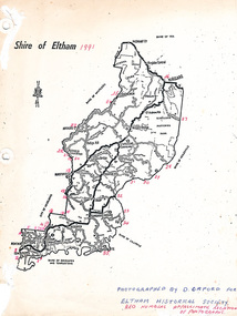 Eltham District Historical Society Inc
Map, Shire of Eltham (boundaries), 1991
Key to a collection of 35 photos taken by Doug Orford at 35 specific locations along the exact boundary of the then Shire of Eltham.