-
 Eltham District Historical Society Inc
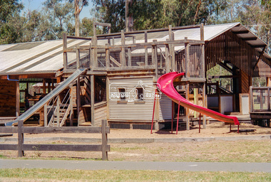
Negative - Photograph, Eltham North Adventure Playground, Wattletree Road, Eltham, 1998c
Roll of 35mm colour negative film, 8 strips and associated 10 x 15 cm colour printKodak Gold 100-5north eltham, north eltham adventure playground, wattletree road -
 Eltham District Historical Society Inc
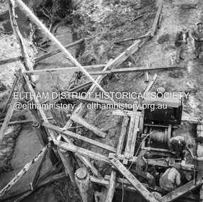
Negative - Photograph, J.A. McDonald, Pinnacle Lane, Steels Creek, Sep. 1955
The old bridge from top of pile frameRecord of various Shire of Eltham infrastructure works undertaken during the period of 1952-1962 involving bridge and road reconstruction projects, sometimes with Eltham Shire Council Project Reference numbers quoted. It was during this period that a number of significant improvements were made to roads and new bridges constructed within the shire that remain in place as of present day (2022). In many situations, the photos provide a tangible visible record of infrastructure that existed throughout the early days of the Shire. The album was put together by or under the direction of the Shire Engineer, J.A. McDonald.1955-09, pinnacle lane, steels creek, bridge construction, infrastructure, shire of eltham -
 Whitehorse Historical Society Inc.
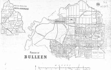
map, Parish of Bulleen, Not dated
A map on the parish of Bulleen.Parish of Bulleen with North East portion of the Parish of Nunawading [n.d. 1890's?]A map on the parish of Bulleen.shire of bulleen, shire of nunawading, land settlement -
 Stawell Historical Society Inc
Map - Electoral Map, Local Government, Local Government Boundry Status as at 31st January 1995, 1995
Electoral mapTwo (2) Maps Overprinted in Red Showing Local Government Boundries for State and port Phillip AreaSheet 1 of 2 Sheet 2 of 2government -
 Wodonga & District Historical Society Inc
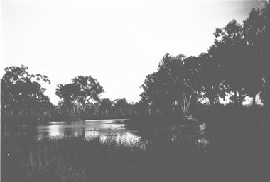
Negative - Haeusler Glass Negatives Collection - Water view near Wodonga, c1910
The Wodonga Historical Society Haeusler Collection provides invaluable insight into life in late nineteenth and early twentieth century north east Victoria. The collection comprises manuscripts, personal artefacts used by the Haeusler family on their farm in Wodonga, and a set of glass negatives which offer a unique visual snapshot of the domestic and social lives of the Haeusler family and local Wodonga community. The Haeusler family migrated from Prussia (Germany) to South Australia in the 1840s and 1850s, before purchasing 100 acres of Crown Land made available under the Victorian Lands Act 1862 (also known as ‘Duffy’s Land Act’) in 1866 in what is now Wodonga West. The Haeusler family were one of several German families to migrate from South Australia to Wodonga in the 1860s. This digital image was produced from one of the glass negatives that form part of the collection, probably taken by Louis Haeusler (b.1887) with the photographic equipment in the Wodonga Historical Society Haeusler Collection. This item is unique and has well documented provenance and a known owner. It forms part of a significant and representative historical collection which reflects the local history of Wodonga. It contributes to our understanding of domestic and family life in early twentieth century Wodonga, as well as providing interpretative capacity for themes including local history and social history.Digital image created from the Haeusler Glass negative collection. A view of water between trees near Wodonga, Victoria C. 1910wodonga pioneers, haeusler family, glass negatives, dry plate photography, wodonga -
Bendigo Historical Society Inc.
Map - BAMAWM : COUNTY OF BENDIGO, 19-8-24
Map. Bamawm, County of Bendigo, Turrumberry, Pannoobamawm, Diggorra, Ballendella, Millewa. Photo-Lithographed at the Department of Lands and Survey, Melbourne by W.J. Butson, 19-8-24, Price 1/-. (number 50 in map cupboard 1)W.J. Butsonmap, bendigo, bamawm -
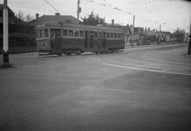
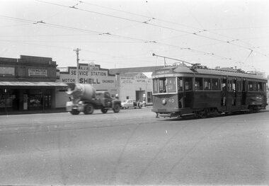 Ballarat Tramway Museum
Negative - Tram 40 - Mercer St, city end, early 1956
Photo shows Geelong tram 40 Mercer St, city end. The tram has the destination of North. In the background is a typewriter shop, R J Reynolds? Shell service station and S G Winkler Service station with a Neptune sign. The driver has his hand on the air brake and the controller with the front driver's window open. One of a set of photos was taken between 15/2/1956 and 3/3/1956 when services operated only between Belmont and North before the final closure of the Belmont route on 25/31956 and that bogie tram 31 is not shown on the board, having gone to Ballarat on 15/2/1956 - see item 5554. See item 8213 for an article on the Geelong system by Keith Kings. Yields information about the Geelong operations toward the closure of the tram system.Black and white Negative - 120 sizetramways, geelong, tram 40, north, mercer st -
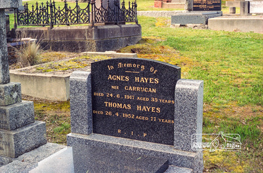 Eltham District Historical Society Inc
Negative - Photograph, Harry Gilham, Grave of Agnes Hayes (nee Carrucan) and Thomas Hayes, Eltham Cemetery, Victoria, Sep 2009
Agnes Hayes was the daughter of Peter and Hannah Carrucan. Peter Carrucan, born in 1837, was the fourth child of Patrick and Bridget Carrucan. He came to Australia with his betrothed Hannah Woods in 1858 and joined his older brother and sister in Eltham. Peter and Hannah also had 10 children: Patrick, Hannah, John, Michael, Peter, Francis, Denis, James, Margaret and Agnes. In Memory Of Agnes Hayes nee Carrucan Died 24.6.1917 aged 35 years Thomas Hayes Died 26.4.1952 aged 77 years R.I.P.Roll of 35mm colour negative film, 6 stripsKodak GC 400-9agnes hayes (nee carrucan), eltham cemetery, gravestones, thomas hayes -
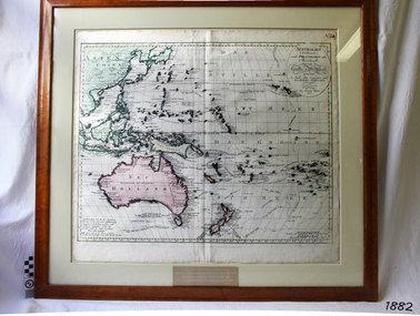 Flagstaff Hill Maritime Museum and Village
Map, Australien (Sudland) auch Polynesien oder Inselwelt, insgemein der funfte Welltheil, c.1990
This map is a reprint of Johann (Johannes) Walch’s “Australien (Sudland) auch Polynesien oder Inselwelt, insgemein der funfte Welltheil”, published in 1802. It shows Australia, New Zealand, South East Asia and the Pacific Islands shows a large number of places names, many of which have changed since the map was drawn. The map includes the routes and dates of the voyages of Tasman, Cook, Bougainville, Carteret, Byron, and others up to 1802. The shapes of the lands on this early map show that some of the areas had not yet been charted. The map was donated to Flagstaff Hill Maritime Village in April 1990 by the Group Study Exchange Team from Rotary District 233, Sweden. It was framed and presented by Rotary District 978 and presented by Barry Lange, the Governor of District 978 in 1989-90. (District 978, Geelong East, is now District 9780.) Johann (Johannes) Walch Johann Walch, painter and engraver, was born in 1757. He was well known for creating miniature portraits. He gained his training in Geneva, Venice and Rome. His publications include atlases and sheet maps, many of which were reprinted after his death in 1816. This reprint of an 1802 is significant for its historical and geographical contant, showing the voyages of many early explorers to the southern regions of the world including Australia. It also shows the early names used for countries and towns and is a valuable reference to historical interpretation. The map itself is a fine example of hand drawn and hand coloured maps of the early 19th century, the method of production, detail included, layout, symbols and so forth.Map, reprint of Johann (Johannes) Walch’s “Australien (Sudland) auch Polynesien oder Inselwelt, insgemein der funfte Welltheil “, first published by in Ausburg in 1802. The image on this Map No 5B, shows Australia and the south Pacific. The timber framed, glass covered, printed and coloured map was created in two sections and joined. Brass plaque at base of map states that the map was presented to Flagstaff Hill by Rotary International in April 1990. Feint lines used for aligning lettering can be seen on the map and there are large erased letters such as a “D” and “S” that are almost obscured.Plague “ROTARY INTERNATIONAL / THE MAP WAS DONATED BY THE GROUP STUDY EXCHANGE TEAM / FROM ROTARY DISTRICT 233 SWEDEN IN APRIL 1990 / AND WAS FRAMED AND PRESENTED BY ROTARY DISTRICT 978 / BARRY LANGE – GOVERNOR DISTRICT 978 1989/90” Stamped on back “ELLIMINOOK FRAMES / MRS. JILL FALKINER / ELLIMINOOK / BIRREGURRA, VIC. 3242 / PHONE: (052) 36 2080” flagstaff hill, warrnambool, shipwrecked coast, flagstaff hill maritime museum, maritime museum, shipwreck coast, flagstaff hill maritime village, great ocean road, australien (sudland) auch polynesien oder inselwelt, insgemein der funfte welltheil, johann (johannes) walch, cartographer johann (johannes) walch, ausburg publisher johann (johannes) walch, johann (johannes) walch map number 5b, 1802 map of australia and south pacific, rotary international group study exchange team, rotary district 233 sweden, elliminook frames, voyages of tasman, voyages of cook, voyages of bougainville, voyages of carteret, voyages of byron, barry lange, painter of miniature portraits johann (johannes) walch -
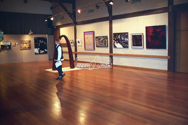 Eltham District Historical Society Inc
Negative - Photograph, Art show, Eltham Community Centre, c.1994
Art show held in the Eltham Community CentreRoll of 35mm colour negative film, 1 stripKodak Gold 100-4art exhibition, eltham community centre -
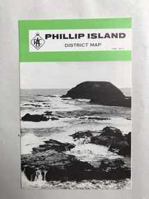 Robin Boyd Foundation
Map, RACV, Phillip Island District Map
walsh st library -
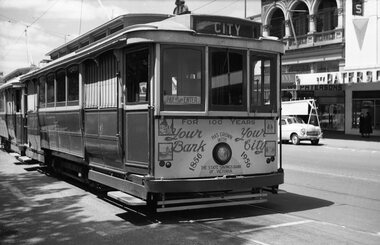 Ballarat Tramway Museum
Negative, Wal Jack, 1956
Yields information about Ballarat trams and use for a full size advert panel on the front advertising 100 years of the State Savings Bank of Vic.Negative and Digital images of the Wal Jack Ballarat Negative file of No. 25 in the City Loop, during 1956 with a full size advert panel for the State Savings Bank of Victoria, 100 years serving the community. In the background is the Paterson's store. trams, tramways, city loop, sturt st, tram 25 -
Federation University Historical Collection
Map - Plan, Ballarat Deep Leads and Mines, 1992
This is Bulletin No. 62: Deep Lead Gold Deposits in Victoria. Map No.6 Ballarat Sheet 1 of 2 The map shows geology, topography and information on mines in the following areas: one large map of the Ballarat area with five enlargements for: Sago Hill District; Scarsdale District; Pitfield Plains District; Berringa Gold Field and Rokewood District. Ballarat Mines and Deep Leads Report No.94 (Finlay and Douglas,1992) provides a summary of the Geological Survey of Victoria mines database, references and geology for most of the mines on this map. Geology Compilation: simplified from earlier Departmental mapping with minor field checking by E.N.M. Plier-Malone. Very large rectangular sheet of paper with seven coloured maps of various sizes and a small green rectangle on the bottom rhs with a map of Victoria superimposed over a poppet head. this rectangle includes information of the other maps shown. The background for these maps is white. Also includes tables of names of mine companies, name of shafts and gold production.gold mines of australia, gold mines of victoria, gold mines- ballarat and district, gold mines pitfield plains district, gold mines scarsdale district, gold mines berringa gold field, gold mines rokewood district, gold mines sago hill district, map - gold mines, map - gold mines in victoria, ballarat, pitfield, scarsdale, berringa, rokewood, sago hill, deep lead gold deposits in victoria, geological survey - gold deposits in victoria, mining, gold deposits in victoria, gold mines in victoria, rokewook, pitfield plains -
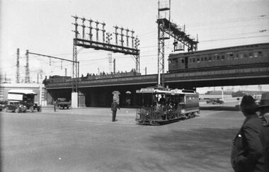 Melbourne Tram Museum
Negative, 1936
Negative of cable tram crossing from Queensbridge Road into Market St after passing under the railway underpass, along Flinders St. In the background is a the bridge with a Tait train crossing, a work or ballast train on the bridge and the signal gantry. There is a policeman on point duty. The cable tram has the destination of Collins St.trams, tramways, cable trams, flinders st, market st, collins st, railways -
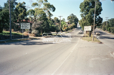 Eltham District Historical Society Inc
Negative - Photograph, Main Road, Eltham, c.Dec. 1983
Road sign advising of proposed reconstruction works of Main Road to install a roundabout at Mount Pleasant Road. Traffic to Lower Plenty and Templestowe to be diverted down Bridge Street (and Bolton Street) effective January 1984. The proposed roundabout did not proceed. Instead traffic islands on Mount Pleasant Road were installed in place of temporary blocked out islands.Film - Kodak CM 400 5079 7 strips, 26 framesinfrastructure, roads, road construction, roundabout, road sign, main road, mount pleasant road -
Bendigo Military Museum
Financial record - DEPOSIT BOOK, WOMENS AUXILIARY BRSL, C. November 1975
Cash and Cheque deposit book Australian and New Zealand Banking Group Ltd used by the Bendigo RSL Womens Auxiliary. The first entry is on 6.11.1975 for $389.30 being for cards, catering and a donation. The last is 2.12.1977 for $51.00 being for a donation.Deposit book blue covers ANZ Banking Group, all print in black, entries are blue, all pages left are duplicate carbon copies, there are a number of blue credit slips pinned to pages, the blue carbon paper at the end of the book are gone, pages are stamped in a red ANZ stamp.On the front in blue pen, "Auxiliary"brsl, smirsl, auxiliary, deposit, cheque, wabrsl -
Whitehorse Historical Society Inc.
Map, Municipality of Nunawading, c1950
Plan No 234, compiled and photo-lithographed at the Melbourne and Metropolitan Board of Works under the direction of G.R. McGowan, Chief Surveyor.Plan No 234, compiled and photo-lithographed at the Melbourne and Metropolitan Board of Works under the direction of G.R. McGowan, Chief Surveyor. Covers the area each Side of Canterbury Road from Orchard Grove to Vernon Street. Includes detail of creeks.Plan No 234, compiled and photo-lithographed at the Melbourne and Metropolitan Board of Works under the direction of G.R. McGowan, Chief Surveyor. blackburn south, gardiners creek, blackburn, blackburn creeklands -
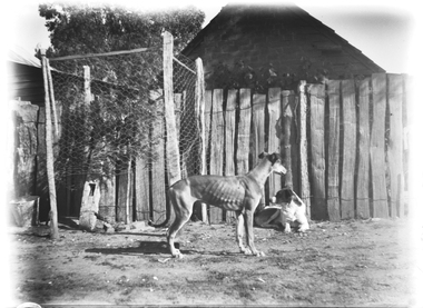 Wodonga & District Historical Society Inc
Negative - Haeusler Glass Negatives Collection - Two dogs, c1910
The Wodonga Historical Society Haeusler Collection provides invaluable insight into life in late nineteenth and early twentieth century north east Victoria. The collection comprises manuscripts, personal artefacts used by the Haeusler family on their farm in Wodonga, and a set of glass negatives which offer a unique visual snapshot of the domestic and social lives of the Haeusler family and local Wodonga community. The Haeusler family migrated from Prussia (Germany) to South Australia in the 1840s and 1850s, before purchasing 100 acres of Crown Land made available under the Victorian Lands Act 1862 (also known as ‘Duffy’s Land Act’) in 1866 in what is now Wodonga West. The Haeusler family were one of several German families to migrate from South Australia to Wodonga in the 1860s. This digital image was produced from one of the glass negatives that form part of the collection, probably taken by Louis Haeusler (b.1887) with the photographic equipment in the Wodonga Historical Society Haeusler Collection.This item is unique and has well documented provenance and a known owner. It forms part of a significant and representative historical collection which reflects the local history of Wodonga. It contributes to our understanding of domestic and family life in early twentieth century Wodonga, as well as providing interpretative capacity for themes including local history and social history.Digital image created from the Haeusler Glass negative collection. Two dogs in front of a wooden fence. The side of a house is visible behind the fence.wodonga pioneers, haeusler family, glass negatives, dry plate photography, wodonga families -
 Eltham District Historical Society Inc
Negative - Photograph, J.A. McDonald, Heidelberg-Kinglake Road, Mar. 1960
Job 56M431 ?? ?? bridge and curve improvement to south of Yow Yow Creek March 1960 Contractor W.E. Wolf – Bridge, F.C. Wood - RoadRecord of various Shire of Eltham infrastructure works undertaken during the period of 1952-1962 involving bridge and road reconstruction projects, sometimes with Eltham Shire Council Project Reference numbers quoted. It was during this period that a number of significant improvements were made to roads and new bridges constructed within the shire that remain in place as of present day (2022). In many situations, the photos provide a tangible visible record of infrastructure that existed throughout the early days of the Shire. The album was put together by or under the direction of the Shire Engineer, J.A. McDonald.infrastructure, 1960-03, bridge construction, cherry tree road, heidelberg-kinglake road, road construction, shire of eltham -
Glenelg Shire Council Cultural Collection
Negative - Negative - Nun's Beach, Portland, c. 1934
Negative for black and white photograph. Nun's Beach. Walkway to baths in foreground, camels sitting on beach. Whaler's Bluff with lighthouse and water tower in backgroundnegative, zillah maschmedt, nuns beach, portland, camels -
 Melbourne Tram Museum
Negative, Wal Jack, c1951
Black and white negative, by Wal Jack, of VR 40 at the Brighton Beach terminus. Tram has the destination of St Kilda Rly (Railway Station) and two Robur Tea/Coffee adverts on the roof.trams, tramways, brighton beach, vr trams, st kilda brighton, tram 40 -
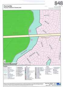 Greensborough Historical Society
Map, Plenty River Children's Cemetery - location map, 1848-1860
The unmarked graves of the children of two Greensborough pioneer families lie in a private cemetery on the Plenty River. Burials occurred between 1848 and 1860.The significance lies in the association with two of the pioneer families of the Greensborough district. Descendants of both families still live in the area.One page map accompanies article item #804 -
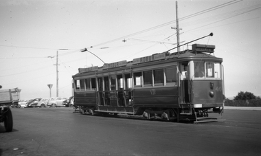
 Ballarat Tramway Museum
Negative, Wal Jack, late 1940s
Negative and Digital images of the Wal Jack Geelong Negative file of Geelong 35 turning from Pakington St into Aberdeen St on its way to the Station. Photo possibly late 1940's. trams, tramways, geelong, aberdeen st, tram 35 -
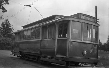 Ballarat Tramway Museum
Negative, mid 1940's
Yields information about the appearance of SEC tram No. 21 in the mid 1940's.Black and white negative of No. 21, at the Lydiard St North terminus? (No buildings in background) Tram has the destination of Grey St Sebastopol. Note the pan in the overhead to assist the trolley pole positioning at night. Negative scanned at hi res 4/6/2020 and image updated.trams, tramways, lydiard st nth, overhead, tram 21 -
 Eltham District Historical Society Inc
Negative - Photograph, J.A. McDonald, General; Shire Offices, Sep. 1959
Shire of Lilydale, 15 Anderson Street, LilydaleRecord of various Shire of Eltham infrastructure works undertaken during the period of 1952-1962 involving bridge and road reconstruction projects, sometimes with Eltham Shire Council Project Reference numbers quoted. It was during this period that a number of significant improvements were made to roads and new bridges constructed within the shire that remain in place as of present day (2022). In many situations, the photos provide a tangible visible record of infrastructure that existed throughout the early days of the Shire. The album was put together by or under the direction of the Shire Engineer, J.A. McDonald.infrastructure, 1959-09, benchmark studies, lilydale shire office, scan - 120 format 6x6 negative -
 Eltham District Historical Society Inc
Negative - Photograph, J.A. McDonald, Eltham-Yarra Glen Road, Lower Plenty, c. July 1962
View looking west across the Eltham-Yarra Glen Road approaching the Lower Plenty Bridge near turn-off for the Golf Club Hotel. Present-day Lower Plenty Road follows a revised alignment across a new bridge. The former bridge is now part of the Plenty River Trail and Edward Willis Court now follows this section of the original Eltham-Yarra Glen Road.. The Golf Club Hotel is gone and a new Lower Plenty Hotel was built slightly further up the hill.Record of various Shire of Eltham infrastructure works undertaken during the period of 1952-1962 involving bridge and road reconstruction projects, sometimes with Eltham Shire Council Project Reference numbers quoted. It was during this period that a number of significant improvements were made to roads and new bridges constructed within the shire that remain in place as of present day (2022). In many situations, the photos provide a tangible visible record of infrastructure that existed throughout the early days of the Shire. The album was put together by or under the direction of the Shire Engineer, J.A. McDonald.1962-07, shire of eltham, old eltham road, edward willis court, eltham-yarra glen road, golf club hotel, infrastructure, lower plenty, road construction -
Whitehorse Historical Society Inc.
Map, Blackburn Shopping Centre, 2006
Plan of Blackburn Shopping Centre c.1954, drawn by Bob Hoskins, showing businesses trading at that time.Plan of Blackburn Shopping Centre c.1954, drawn by Bob Hoskins, showing businesses trading at that time. Refer Tape NP2376 April 2001Plan of Blackburn Shopping Centre c.1954, drawn by Bob Hoskins, showing businesses trading at that time.blackburn shopping centre, hoskins furniture and floor coverings -
Bendigo Historical Society Inc.
Map - UNITED HUSTLER'S & REDAN & K. K. MINES - PLAN OF UNITED HUSTLER'S & REDAN & K. K. MINES
Plan of the United Hustler's & Redan & K. K. Mines on the Hustler's Line of Reefs Bulletin No 33 Plate No XXVIII. Plan shows depth of levels, stone encountered and some geological features. Geological Survey of Victoria emblem and signed by H S Whitelaw, Underground Survey Office Bendigo, September 1913. This item has not been scanned or photographed.mining, parish map, united hustler's & redan & k. k. mines, united hustler's and redan shaft, k. k. shaft, h s whitelaw -
 Eltham District Historical Society Inc
Negative - Photograph, Open Day, Eltham Living and Learning Centre, 7 Nov 1987
Gillian Barclay, Coordinator Living and Learning; Open Day, Eltham Living and Learning Centre, part of the Eltham Community Festival activites, 7 Nov. 1987eltham, eltham festival, eltham living and learning centre, living and learning centre, open day, gillian barclay -
Glenelg Shire Council Cultural Collection
Negative - Negative - panorama of Nelson, Victoria, 1934
Part of a collection of photographs taken by Zillah Maschmedt in 1934. Zillah was a teacher from South Australia.Transparency for black and white photo. Panoramic view of Nelson Viczillah maschmedt, photography, panorama, glenelg river, nelson