-
 Moorabbin Air Museum
Plan (item) - Bristol Aeroplane 170 schematic drawings, Assembly of Pitot Head at Stn. 13 - 25
Bristol Aeroplane Company Ltd -
 University of Melbourne, Burnley Campus Archives
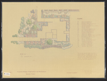
Plan, James Hitchmough, Sunken Garden, 1981-1989
Most plans were held in Geoff Olives's office.(1) Sunken Garden. 1 tracing paper copy and 1 paper, laminated, coloured. Designed by Dr. James Hitchmough, drawn by Jill Kellow c1989. Plants supplied by Victorian Wholesale Nurseries Pty. Ltd. (2) The Sunken Garden. 1 tracing paper, partly coloured, 1 paper copy. Designed by James Hitchmough, drawn by Jill Kellow 20.12.1988. (3) Burnley Horticultural College Gardens Development Sunken Gardens: Plan Proposal I, March 1981 on tracing paper. (4) Burnley Horticultural College Gardens Development Formal Sunken Garden Proposal 2, March 1981 on tracing paper. (5) Burnley Horticultural College Sunken Garden Scheme II by G. Olive on tracing paper. Plants supplied by Victorian Wholesale Nurseries P.L. sunken garden, james hitchmough, jim kellow, andrew smith -
Glenelg Shire Council Cultural Collection
Plan - Plans - Port of Portland Slipway - Steel Trawler 'Aqua Enterprise', 02/10/1980
PORT OF PORTLAND AUTHORITYFront: '18' - black texta, top right corner -
Federation University Historical Collection
Plan - Main Street Plan, John Carruthers, Plan of Main Street Ballarat done by J Carruthers 1858, 1858
This is an Historical plan of Ballarat and gives us a look back in time.long thin hand drawn plan of Main Street Ballarat on brown wax paper.j carruthers, main st, main street, free trade hotel, eureka street, specimen hill road, humffray street, star hotel, old kaiser hotel, golden age hotel, royal mail hotel, john carruthers -
 Melbourne Tram Museum
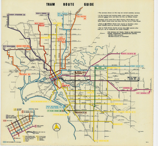
Map, Melbourne & Metropolitan Tramways Board (MMTB), "Tram Route Guide", Jun. 1979
Full colour map or poster printed on clear plastic with an adhesive peel off backing sheets, titled "Tram Route Guide". Map dated 6/79, showing proposed extension to Bundoora, routes with route numbers and names of main destinations. Has notes about the services, weekend and telephone numbers for information. 1979 Two copies held. See Reg Item 3765 for a larger version of this map.trams, tramways, mmtb, map, routes, posters -
Ringwood and District Historical Society
Legal record - Conditions of Sale (C.E.Carter), Ringwood - Crown Allotment 12, D Hodges to Unstated Purchaser - 1925
Particulars and Conditions of Sale of Property , from D Hodges to Unstated -
 Federation University Historical Collection
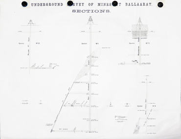
Plan, Underground Survey of Mines at Ballarat Sections
A plan showing the underground sections of the Washington Shaft, Smith's Freehold Shaft and the New Kohinoor Shaft.plans, mining, cgt, washington shaft, smith's freehold shaft, new kohinoor shaft, koh-i-nor -
Ringwood and District Historical Society
Legal record - Conditions of Sale (C.E.Carter), Blackburn - Crown Allotment 77 , D.Casamento to Miss J.A.E. Stallard -1927
Particulars and Conditions of Sale of Property , Lots 13 & 14, Peacedale Estate, Nunawading. From Domenico Casamento to Jessie Stallard. -
Canterbury History Group
Map - Map of Canterbury, Surrey Hills, Mont Albert and Camberwell, c1930s
Map produced and distributed by White & Clarke Real Estate Agents in Canterbury c 1930canterbury, canterbury road, surrey hills, mont albert, camberwell, maps, real estate agents -
Ringwood and District Historical Society
Legal record - Conditions of Sale (C.E.Carter), Mitcham - Crown Allotment 124. M.E.Burke to ? Dated June 1st 1929
Particulars and Conditions of Sale of Property , Lot 44 and 45 on Plan of Subdivision 6736, Mitcham Road, Mitcham. Mrs M.E.Burke to ? -
Whitehorse Historical Society Inc.
Map, Shire of Blackburn and Mitcham, 1938
Plan of Shire of Blackburn and Mitcham showing sections and lot numbers. Scale 8 chains to 1 inch.Plan of Shire of Blackburn and Mitcham showing sections and lot numbers. Scale 8 chains to 1 inch.Plan of Shire of Blackburn and Mitcham showing sections and lot numbers. Scale 8 chains to 1 inch.shire of blackburn and mitcham, blackburn, blackburn north, blackburn south, burwood east, forest hill, mitcham, nunawading, vermont, vermont south -
 Port Melbourne Historical & Preservation Society
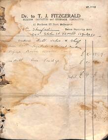
Financial record - Invoice, T J FITZGERALD, Plumber to Mrs STANFORD, Stokes Street, Port Melbourne, 1950
Found at 246 Stokes Street, Port Melbourne. Thomas Joseph FITZGERALD was a plumber during the 1950s and 60s. Initially working from his parents house at 12 Poolman Street, he moved to 77 Ross Street after his marriage to Dorothy Joyce STONE in 1952.Invoice of T J FITZGERALD, Plumber, 12 Poolman Street, to Mrs STANFORD at 246 Stokes Street, for various repairs, 1950.business and traders - plumbers, thomas joseph fitzgerald, mrs stanford -
Ringwood and District Historical Society
Legal record - Conditions of Sale (C.E.Carter), Ringwood , Lot 26 on Plan of Subdivision 10492, Mrs E.A.M.Bourbaud and Mr A.Whamond, 1946
Particulars and Conditions of Sale of Property , from Mrs E.A.M.Bourbaud to Mr A.Whamond, Register No 10492. -
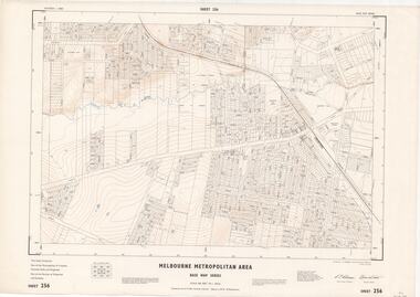 Ringwood and District Historical Society
Map - Melbourne Metropolitan Area Base Map Series, Sheet 256 - Ringwood area, 1962
Map prepared by Dept of Lands and Survey and MMBW from State Aerial Survey December 1956 and Cadastral Survey information December 1962. This sheet comprises parts of the Municipalities of Croydon, Ferntree Gully, and Ringwood, and Parishes of Ringwood and Scoresby.Scale: 400 feet to 1 inch. Contours at 5 feet vertical interval. By Authority: A.C. Brooks, Commonwealth Printer, Melbourne. -
 City of Moorabbin Historical Society (Operating the Box Cottage Museum)
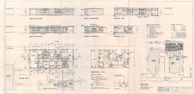
Plan - Building Plans for the proposed vicarage of St George's Church of England Church in Mavho Street, Bentleigh, 1959
St George's Church of England held services in Mavho Street, Bentleigh from 1926 to 1984. A new Church was built in 1955. In 1996 the church property was divided into two lots. On one lot was the church which was converted into apartments. The other lot had the old timber church and the vicarage.Example of the progress of the Municipality of MoorabbinTwo pages of architectual designs for the building of the proposed vicarage St George's Church of England Church in Mavho Street, BentleighArchitectural drawings by The Designers Panelst george's church of england, bentleigh, vicarage, plans, religion -
 Melbourne Tram Museum
Map, Track plan or track map or layout of the Melbourne system, c1973
Track plan or track map or layout of the Melbourne system showing track layout, crossovers, depots, workshops and route numbers, terminus, substations, Bundy clocks, layout of Preston works. On the rear is a detailed layout of the city area. Shows railway stations but not the station names and rivers. Printed on cartridge paper. No details of to who prepared the plan or the drawing or date. Wattle Park line has been duplicated (Sept 1970), but the Essendon Airport line remains (closed Oct. 1976).trams, tramways, mmtb, track layout, junction, depots, substation, plans, trackwork, route numbers, terminus, map, bundy clock -
 Federation University Historical Collection
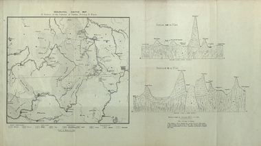
Map, Geological Sketch Map of of Dundas, Berung, and Ripon Counties
Map of the Counties of Dundas, Berung, and Riponcounty of dundas, county of berung, county of ripon, map, geology, ararat, stawell, hamilton, grampians -
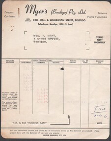 Bendigo Historical Society Inc.
Financial record - Financial record of purchases and payments made by Mrs. W. Gray, 3 Skene Street, Bendigo, circa 1959
social history of Myer business operationsFinancial record of purchases and payments made by Mrs. W. Gray, 3 Skene Street, Bendigo, circa 1959. 10772.34a financial transactions listing purchases and payments. 10772.34b invoices for purchases October 1959.social history -
Bendigo Historical Society Inc.
Map - BENDIGO, 1916
Map. Bendigo, Gunbower, Gladstone, Talbot, Dalhousie, Rodney, Jarklan, Calivil, Hayanmi, Mitiamo, Wanurp, Pannoobamawm, Bamawm, Millewa, Ballendella, Janiember West, Janiember East, Pompapiel, Talambe, Dingee, Milloo, Pannoomilloo, Rochester West, Yarrayne, Salisbury, Yallook, Tandarra, Kamarooka, Warragamba, Diggorra, Minto, Bridgewater, Yarraberb, Neilborough, Whirrakee, Egerton, Elmore, Nolan, Goornong, Bagshot, Huntly, Derby, Leichardt, Nerring, Tarnagulla, Woodstock, Marong, Sandhurst, Wellsford, Bendigo, Axedale, Strathfieldsaye, Eppalock, Kimbolton, Lyell, Sedgwick, Mandurang, Lockwood, Ravenswood, Shelbourne, Laanecoorie. Price 3/-. Smaller map of State of Victoria. Lithographed at the Department of Lands and Survey, Melbourne. 1916. Scale : Two miles to one inch. Map was in book form. (number 62 in map cupboard 1)map, bendigo, bendigo -
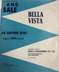 Kew Historical Society Inc
Plan - Subdivision Plan, Bella Vista, Doncaster East
The Bella Vista Subdivision included 101 lots in Murphy Road, Kerry Close, Keir Avenue, Norman Street, Daphne Street in Doncaster East,An undated, four-page colour brochure for the sale of the Bella Vista Estate in Doncaster East. The item includes a separate price list of the home sites maintained by the agent. The latter includes the original and the discounted price. subdivision plans - doncaster east (vic), bella vista subdivision - doncaster east (vic) -
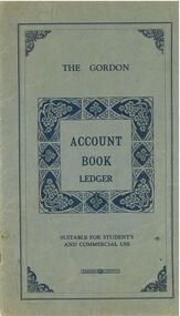
Clunes Museum
Financial record - LEDGER
Used in Theo Harden's Boot and Shoe Emporium in Fraser Street Clunes. Received from Anne and Dennis Robinson of 126 Bailey Street, ClunesLeather ledger with green cover and red "Ledger" label on spine. From Harden's Shoe Shop in Fraser Street.local history, books, ledgerbusinesses of clunes -
Whitehorse Historical Society Inc.
Map, Nunawading - Bromide
Map of the City of Nunawading indicating suburbs - marked 'Bromide'Map of the City of Nunawading indicating suburbs - marked 'Bromide'Map of the City of Nunawading indicating suburbs - marked 'Bromide'maps, city of nunawading -
Port Melbourne Historical & Preservation Society
Map - Aerial view of Port Melbourne, Melbourne Harbor Trust, Apr 1944
Drawing of aerial view of Port Melbourne 1944piers and wharves - miscellaneous, missions to seamen, melbourne harbor trust - port of melbourne authority -
 Bendigo Historical Society Inc.
Financial record - Australian red Cross Kangaroo Flat Branch Account Book
The Gordon - Account Book Ledger - Suitable of Students and Commercial Use. Green Cover with Dark Blue writing and Blue pattern insert in middle. Plain back cover. Australian Red Cross Kangaroo Flat Branch - Account Book June 1940 to June 1944. Summary of Receipts and Disbursements from 13th Nov to 30th June 1940receipts, payments, auditors report -
Port Melbourne Historical & Preservation Society
Plan - Coal tramway, Town Pier to Gas Works via Esplanade West, 1880s
From set of three photocopies of two plans of coal tramway, Town Pier to Gas Works via Esplanade West: Plan of coal tramwaytransport - tramways, utilities - gas, sandridge lagoon, industry - manufacturing, piers and wharves - town pier, metropolitan gas company, australasia sugar refining company, robert harper & co ltd -
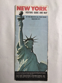 Robin Boyd Foundation
Map, New York Convention and Visitors Centre, New York Visitor Guide and Map: Of the Greatest All-Year-Round Vacation City, 1966
new york city, map, walsh st library -
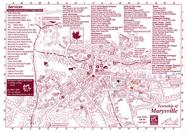 Marysville & District Historical Society
Map (Item) - Information map, Michael Hampton, 2000
An information map of the township of Marysville. This map was produced by McNamara Country Real Estate in 2000. The artist who drew the map was named Michael Hampton.An information map of the township of Marysville.MICHAEL HAMPTON/ 2000 VERSION 1:2/ 01/01marysville, victoria, australia, tourist map, information map, mcnamara country real estate, michael hampton -
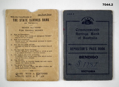 Bendigo Military Museum
Financial record - PASS BOOK, Commonwealth Bank & State Savings Bank, 1943
Ref Cat No 70281. This is a pocket sized bank book. Printing on front is in a dark blue ink. The cover is blue buckram. inside are bank, branch details and hours, plus a line by line bank financial record of deposits and withdrawals. The first record is a deposit of 35 pounds in April 1943. The last balance is shown as 3 ponds 5 shillings and 10 pence. 1 June 1955 Interest. 2. This is a stout khaki bank book holder. Printed articles on it are: - "State Savings Bank Victoria" plus seven reasons for saving money.1. Inside the book is No. “S1287” written in ink. The depositors title written in ink is :- Bendigo Voluntary Aid Detachment No. 352 stamped inside back cover is number “C968324” 2. Nil.ww2, bank book, vad -
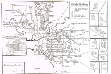
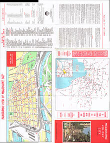 Melbourne Tram Museum
Map, Victour, "Melbourne Holiday City", c1975
Map - 12 fold special size - full colour titled "Melbourne Holiday City", published by Melbourne Tourism, c1975 prior to the construction of East Burwood tram line, providing a list of amusements, tourist locations, places of interest, map provided by Victour, The Victorian Government Tourist Bureau, a panoramic view of Melbourne and a large map of Melbourne and suburbs showing rail, bus and tram lines and key to suburbs. Cover photo with 882 (Route 11, Spencer St) in Collins St looking west with the Westgate bridge in the far background.trams, tramways, map, public transport, city of melbourne, buses, railways, tramways, victour, tram 882 -
Whitehorse Historical Society Inc.
Map, Springvale Road, 1975
Aerial photograph of area around cnr. of Springvale Road and Burwood Highway, south past Highbury Road and East in Vermont South.Aerial photograph of area around cnr. of Springvale Road and Burwood Highway, south past Highbury Road and East in Vermont South.Aerial photograph of area around cnr. of Springvale Road and Burwood Highway, south past Highbury Road and East in Vermont South.aerial photographs, vermont south, highbury road, burwood east, burwood highway, burwood east, burwood east