-
 University of Melbourne, Burnley Campus Archives
Plan, Road Diversions, 1881-1889
Sketch plan of Burnley College grounds showing road diversions in 1881 and 1889.burnley college -
Bialik College
Plan (item) - Site development proposals, Shakespeare Grove, 1986
Site development proposals for 6 Shakespeare Grove, Hawthorn, as part of the Bialik College Strategy Plan, created by Jennings Project Management, October 1986. Includes plan of existing land use and site constraints. Please contact [email protected] to request access to this record.1980s, building and planning -
Whitehorse Historical Society Inc.
Legal record - Land Title, Deep Creek Road, Mitcham, 1936
Certificate of Title vol 6087 Fol 1217316 Lot 133 of plan of subdivision no 8022 in the name of Francisco Schwerkolt on 22 Dec 1936 including transactions until Oct 2000.Certificate of Title vol 6087 Fol 1217316 Lot 133 of plan of subdivision no 8022 in the name of Francisco Schwerkolt on 22 Dec 1936 including transactions until Oct 2000.Certificate of Title vol 6087 Fol 1217316 Lot 133 of plan of subdivision no 8022 in the name of Francisco Schwerkolt on 22 Dec 1936 including transactions until Oct 2000.schwerkolt, francisco, deep creek road, mitcham, no 27., rangeview grove, hogan, frances dora, collins, douglas alexander, oulton alice, vicic, susan manuella, hammond, wayne, alexander, hannelore -
 Federation University Historical Collection
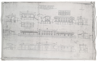
Plan, Copy of a Plan of Serviceton Railway Station Building, 1888
The Serviceton Railway Station was completed in 1889 , with the Colony of Victoria and the Colony of South Australia sharing the cost. Ut was at Serviceton the the Victorian rail line and the Adelaide-Wolseley railway line of South Australia joined. The Railway Station included customs offices which were no longer necessary after the Federation of Australian States in 1901. ( https://en.wikipedia.org/wiki/Serviceton,_Victoria, accessed 30 August 2021)Copy of plan for the Serviceton Railway Linerailway, servicetone railway station, plan, serviceton -
Port Melbourne Historical & Preservation Society
Plan - Seamen's Mission, Harry Norris, Blueprints, 1980s
Plans copied by Brian Couldrey when he was running the Mission Arts Centre in the building (1987 -1991).Photocopies (12) of blueprints of Plans for 1937 Seamen's Mission, by Harry Norris, in A4 sections - Ground floor - sheets f - l and First floor sheets a - e.architecture, missions to seamen, harry a norris -
 Whitehorse Historical Society Inc.
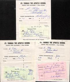
Financial record, St. Thomas The Apostle School, 1970
3 invoices and receipts to J. Foley from St. Thomas The Apostle School3 invoices and receipts to J. Foley from St. Thomas The Apostle School for Christine and Julienon-fiction3 invoices and receipts to J. Foley from St. Thomas The Apostle Schoolst. thomas the apostle primary school, central road blackburn, foley j -
 Whitehorse Historical Society Inc.
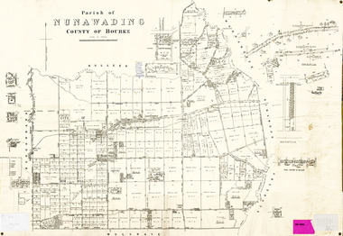
Legal record - Map, Parish of Nunawading, c1930
Office of Lands and survey map, 1864 with many further subdivisions of 1870 onwards added.Office of Lands and survey map, 1864 with many further subdivisions of 1870 onwards added. Boundaries of City of Box Hill included. Note added re Slater's land in Blackburn North. Office of Lands and survey map, 1864 with many further subdivisions of 1870 onwards added. maps, shire of blackburn and mitcham, city of box hill, slater family -
 Federation University Historical Collection
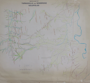
Plan, Sketch Map of Tarnagulla and Newbridge Goldfields, 1979
Pmap on paper with hand colouringtarnagulla, newbridge, map -
Port Melbourne Historical & Preservation Society
Plan - Setting temporary gangway at Inner East berth Station Pier for Tasmanian ferry Abel Tasman, Engineering Division, Port of Melbourne Authority, 1984
Plan: cross section at passenger doors showing deck levels - ship empty highest allowable tide (Drawing used in the setting up of temporary gangway at the Inner East berth of Station Pier for the vessel Abel Tasman) 1984melbourne harbor trust - port of melbourne authority, piers and wharves - station pier, abel tasman -
 Bendigo Historical Society Inc.
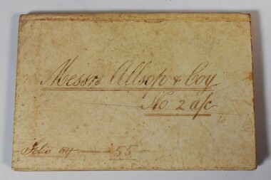
Financial record - Arthur Allsop Collection: Account book
Arthur Allsop went into the business office at Bendigo (Vic.) of the late Mr. Alfred Joseph. He later operated as an independent bookmaker. Arthur Allsop was a partner in the firm of Kelly and Allsop and was involved in mining and speculation in Bendigo. He was elected as a member of the Bendigo Stock Exchange in 1906. He started his athletic career at picnic sports and was a fine athlete winning many foot races. For 15 years he acted as secretary of the Sandhurst City Fire Brigade, he was captain of the Bendigo lacrosse team. He was a fair cricketer, and played against the English and Australian Elevens. He played football, and acted as secretary to the Bendigo Football Club. In later years he played bowls and captained pennant teams. He was a Past District- Grandmaster in the M.U.I.O.O.F. Allsop eventually moved to Melbourne and then Sydney working as a bookmaker. He died in Sydney in 1921. His wife Belle died in Bendigo in 1914 and is buried in the Bendigo Cemetery.Bank account book used by Bookmaker Arthur Allsop. Cream coloured hard cover. Written on the front Messrs. Allsop & Coy. No 2 Account. Printed on the first page The Commercial Bank of Australia Limited Sandhurst Branch in Account Current with A Allsop and Coy Bookmaker. Pages have ruled columns. Records payments and withdrawals from the account. Dated from August 1889 to May 1891. Final balance £6039.9.4bookmaker, arthur allsop, bank account -
Ringwood and District Historical Society
Legal record - Conditions of Sale (C.E.Carter), Ringwood - Lot 30, Plan of Subdivision No 10507, J Roberts to M McEwan, 1926
Particulars and Conditions of Sale of Property , from John Roberts to Michael McEwan -
Ringwood and District Historical Society
Legal record - Conditions of Sale (C.E.Carter), South Warrandyte , Lot 8, 9, 10,11, 12 on Plan of Subdivision 15580, Mrs E.Milner and Mr K.G.Thomson, 1944
Particulars and Conditions of Sale of Property , from Mrs E.Milner to Mr K.G.Thomson, Register No 15580. -
Moorabbin Air Museum
Plan (item) - C.A.C Plan XP.66
-
Moorabbin Air Museum
Plan (item) - Cabin Section Assy Composite Maintenance TRNR United Technologies Sikorsky Aircraft Drawing 65725-72230 Rev.2
-
Port Melbourne Historical & Preservation Society
Financial record - PMHPS, Pat Grainger, Annual Report 2000, Aug 2000
PMH&PS was incorporated in 1994, and from 1995 was required to hold an AGM and present an Annual Report. These were compiled, designed, printed on photocopier and bound by the Secretary, except for the Tenth anniversary edition.Annual Report of the PMH&PS, 2000 A5 8 pp plus cover - light brown with handwriting from early document as background texture. Contains financial reports, list of members, Phillip Williams illustration of Gellibrand lighthouse and photos from two festivals - Lee-ar-day Days and Back to Port.societies clubs unions and other organisations, port melbourne historical & preservation society, pmhps, ann gibson, phillip williams, ted kobelt, lois daley, glen stuart, maralyn kobelt, glen cosham -
 Bendigo Historical Society Inc.
Legal record - Contract, 16/10/1952
Newsprint Contract between Messrs. Bowaters Sales Company Limited London and The Bendigo Advertiser Newspapers. Contract is for 10 years to purchase 280 long tons of newsprint per annum. Tan Foolscap folder and 3 pages of typewritten contract. Page three has a 6d Revenue Postage stamp attached. This entire item is held together by a pink ribbon through two punched Holes.bendigo advertiser, bowaters, newspapers -
Port Melbourne Historical & Preservation Society
Legal Record - Affidavit, Missing licence, Foresters Arms Hotel, Dec 1885
01 Affidavit (handwritten on pale blue printed legal form) and 02 'The Eighth Schedule' (handwritten on poor paper, stained and insect damaged) regarding missing licence during transfer of the Foresters Arms Hotel licence from Thomas De Gruchy to Henry Charles Sansom, 18852hotels, business and traders, built environment - commercial, thomas degruchy, henry charles sansom, foresters arms hotel -
 Federation University Historical Collection
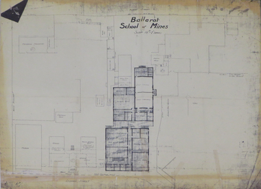
Plan, Ballarat School of Mines 'Old Chemistry Building' Plan
Ballarat School of Mines is a predecessor institution of Federation University Australia. Two plans showing the Ballarat School of Mines Old chemistry Building and the Ballarat Technical Art School Building. It also shows the location of the Ballarat School of Mines Model Mine, Battery House, etc.ballarat school of mines, model mine, battery, old chemistry building, ballarat technical art school, laboratory, plan, architectural plans -
Moorabbin Air Museum
Plan (item) - Bristol Aeroplane 170 schematic drawings, Assy of Prop Controls ( De Havilland )
Bristol Aeroplane Company Ltd -
 Glen Eira Historical Society
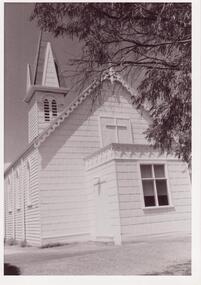
Plan - Trinity Congregational Church, Glen Huntly
Black and white photograph donated in 2002 by Bob Sinclair. Shows front porch. Hand drawn plan of rear interior of Trinity Congregational Church. Shows plan of doors and windows as well as circular leadlight window and vestry doors. Not Known by whom or date.trinity congregational church, primitive methodist church., grange road., glen huntly, sinclair bob -
Glenelg Shire Council Cultural Collection
Plan - Ship Plan / Mould, n.d
Wooden pattern for mould for boat fittings. Circular base, circular knob attached to top, painted green. -
 Greensborough Historical Society
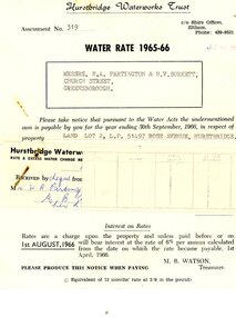
Financial record - Account, Hurstbridge Waterworks Trust, Hurstbridge Waterworks Trust water rate assessment 1965-66, 13/05/1965
Hurstbridge Waterworks Trust water rates accounts for land jointly owned by W.A. (Alan) Partington and H.V. (Horrie) Burkett for 2 properties in Hurstbridge (Rose Avenue and Daphne Crescent.Alan Partington and Horrie Burkett had a history of joint property ownership from their early days in Warragul.2 Water rates accounts, black text on white paperHandwritten receipt.alan partington, william alan partington, partington family, horrie burkett, hurstbridge, hurstbridge waterworks trust -
 Kew Historical Society Inc
Plan, Melbourne & Metropolitan Board of Works : Borough of Kew : Detail Plan No.1571, 1904
The Melbourne and Metropolitan Board of Works (MMBW) plans were produced from the 1890s to the 1950s. They were crucial to the design and development of Melbourne's sewerage and drainage system. The plans, at a scale of 40 feet to 1 inch (1:480), provide a detailed historical record of Melbourne streetscapes and environmental features. Each plan covers one or two street blocks (roughly six streets), showing details of buildings, including garden layouts and ownership boundaries, and features such as laneways, drains, bridges, parks, municipal boundaries and other prominent landmarks as they existed at the time each plan was produced. (Source: State Library of Victoria)This plan forms part of a large group of MMBW plans and maps that was donated to the Society by the Mr Poulter, City Engineer of the City of Kew in 1989. Within this collection, thirty-five hand-coloured plans, backed with linen, are of statewide significance as they include annotations that provide details of construction materials used in buildings in the first decade of the 20th century as well as additional information about land ownership and usage. The copies in the Public Record Office Victoria and the State Library of Victoria are monochrome versions which do not denote building materials so that the maps in this collection are invaluable and unique tools for researchers and heritage consultants. A number of the plans are not held in the collection of the State Library of Victoria so they have the additional attribute of rarity.Original survey plan, issued by the MMBW to a contractor with responsibility for constructing sewers in the area identified on the plan within the Borough of Kew. The plan was at some stage hand-coloured, possibly by the contractor, but more likely by officers working in the Engineering Department of the Borough and later Town, then City of Kew. The hand-coloured sections of buildings on the plan were used to denote masonry or brick constructions (pink), weatherboard constructions (yellow), and public buildings (grey). This plan is the other half of Plan No.1571 representing the constructions to the west of Wellington Street before and in 1903/4. This plan represents the built environment in Edgevale Road, Wellington Street, Atkins Street, Annadale Street, Mortimer Street, and Cotham Road. Whereas there are smaller allotments and more modest housing stock facing Edgevale Road, larger blocks and more substantial houses are represented facing Cotham Road.melbourne and metropolitan board of works, detail plans, mmbw 1571, cartography -
Moorabbin Air Museum
Plan (item) - Bristol Aeroplane 170 schematic drawings, Skin Reinforcing Plate
Bristol Aeroplane Company -
Moorabbin Air Museum
Plan (Item) - Plan CASA C101 AV10Jet Ex GAF
-
Moorabbin Air Museum
Plan (item) - Bristol Aeroplane 170 schematic drawings, Additional Bolts at Top Boom Rear Spar
Bristol Aeroplane Company Ltd -
Port Melbourne Historical & Preservation Society
Plan - Annotated and handcoloured by Peter Libbis to indicate his research into Libbis family residences and hotels on copy of a section of an MMBW map, Melbourne and Metropolitan Board of Works, c. 1980s
Peter Libbis obtained these copies from the MMBW when he researched his family history in the 1980s. He has annotated them, colour in hotels etc. Donated to Society in 1997.One of a group of 19 photocopies of various 20th century MMBW plans, annotated/coloured in to indicate residences of Libbis family and local hotels, by Peter Libbis in family and hotel research - Harper's and lagoon, 1950s?hotels, built environment, melbourne & metropolitan board of works -
 Mission to Seafarers Victoria
legal record (item) - Register, Marriage Register, Circa 1947
The register documents twenty-five weddings that took place in the Mission to Seamen's church district between the 21st of April, 1947 to the 8th of June 1950. Each certificate is a record of all the information needed to legalise a marriage under Commonwealth law, such as names, dates of birth, marital status, parents and employment. Within the register, there are four Forms of Consent, used when the bride or groom were below the age of twenty-one. There is a memo confirming the death of one bride's previous husband, a letter confirming one groom was actually a bachelor, and letters from a ship's captain, swearing a bride and groom are both unmarried.The register is a historical record of weddings performed at the Mission to Seamen church between 1947 to 1950.On front cover, handwritten in blue ink: REGISTER NO 6 / 21-4-47 - 8-6-50 / NOTE NO 94 (underlined) / CELEBRATED AT ST NICHOLAS'MARINERS'CHURCH / WILLIAMSTOWN / NO 103 (underlined) AT ST ANDREWS " " / PORT MELBOURNEwedding, marriage, 1947-1950, register, church, marriages, dio-marriages, mission to seafarers, seamen's mission -
 Federation University Historical Collection
Plan, Ballarat East, 1957
Dr George Clendinning and others were trustees of the Church of England (St Paul's) A number of enlargements of the Ballarat East maps. .4) Bakery Hill, Humffray Street, Victoria Street, Ballarat Youth Council .5) Specimen Vale, Victoria Street, Eureka Street, Housing Commission .10) - Tomber Reserve, York Street, Spencer Street, Bennett Street, Wilson Street, Rodier Street, Richard Street, Fussell Street, Turpie Street, Stockade Street, Ballarat Rifle Range Lal La Street, Clayton Street, Eureka Street Sheet 2 - Yarrowee Creek, High Street, Dinney's Dam, Binney Street, Oliver Street, Humffray Street, Morres Street, Finch Street, Scotts Parade, Rice Street, HOrnby Street, Queen Street, Newman street, King Street, Napier Street, Sim Street. Sheet 3 - Russell Square, Victoria Street, Orphan Asylum, Ballarat Orphanage, Lofven Street, Haines Street, Yarrowee Creek, Ching Who Coey, Chinese, Stawell Street, Rice Street, Lane Street, Humffray Street, Nelson Street, Coffield Street, Morres Street, Western Highway, Rodier Street, Scott Parade, Canterbury Street Sheet 4 - Orphan Asylum, Ballarat Orphanage School, Fortune Street, Scotts Parade, Water Street, Ritchie Street, Humffray Street, Brophy Street, Thompson Street, Victoria Street,Humffray Street Church of England Reserve, Strickland Parade. Mount Xavier Recreation Reserve, Charlesworth Street Catholic Church Reserve. Sheet 5 - Western Highway, Mount Street, Fortune Street, Finlay Street, Jones Street, Ryan Street, Water Street, Brandbury Street, Humffray Street. Sheet 6 - Barkly Street, Ebden Street, Grenville Street, Cameron Street, Peel Street, Young Street, Victoria Street, Steinfeld Street, Haymes Street, Bond Street, Anderson Street, Eastwood Street, Mair Street, East Street, Haymes Crescent Sheet 7 - Murphy Street, Queen Street, Dyte Parade, Princes Street, Midland Highway, York Street, Dodds St, Wilson St Otway Street, Specimen vale, King Street, Gray Street, Little Dodds Street, Eureka Street. Sheet 9 - Richards Street, Fussell Street, Stockade Street, Orphan Asylum, Ballarat Orphanage, Elford Street, Russell Street, Ross Street, Charlesworth Street, Lalor Street, Stockade Street, Wilson Street, York Street, Eureka Street Sheet 10 - Eureka Street, York Street, Elford Street, Wilson Street, Mount Street, Turpie Street, Timber Reserve, Mount Xavier Sheet 11 - Yarrowee Creek, Humffray Street, Barkly Street, Morton Street, Cobden Street, Morton Street Wesleyan Church, Pryor Street, Albion Street, Bradshaw Street, Ballarat Woollen Mills, Tannery, Mount Pleasant. Sheet 12 - Magpie Street, Grant Street, Gladstone Street, Cobden Street, Fraser Street, Grenfell Street, Robertson Street, Bond Street, Barkly Street, Vine Street, Sovereign Hill, Ballarat Observatory, Pearce Street, Bond Street. Sheet 13 - Murphy Street, Larter Street, midland Highway, Geelong Road, gales Street, Lal Lal Street, Clayton Street, Dodds Street, Elsworth Street Sheet 14 - Eureka Street, Eureka Stockade Memorial Park, Eureka Stockade Reserve. York Street, Joseph Street, Kline Street, Charlesworth Street, Chamberlain Street, Trevor Street, Belford Street, Queen Street, Murray Street, Eureka Tiles, Orphan Asylum, Ballarat Orphanage. Sheet 18 - Scotts Parade, Stawell Street, Fortune Street, Victoria STreet, Railway Line, Haines Street, Eureka Street, Elford STreet, Brophy Street, York Street, Clayton Street, Elsworth Street, Barkly Street, Humffray Street, Midland Highway, Princes Street ballarat youth council, ballarat east, bakery hill, humffray street, victoria street, st paul's anglican church, humffray street state school -
 Phillip Island and District Historical Society Inc.
Financial record, Credit account from J.Kennon & Sons for N. L. Smith, Rhyll, 23 March 1914
J.Kennon & Sons were known particularly for their use of the chrome tanning process. They were also buyers and exporters of Australian skins and wool.The firm had tanning works,, established in 1863, offices and stores in the vicinity of River Street, Richmond and a leather warehouse in Bridge Road. [ Source -Heritage Victoria https://www.google.com/url?sa=t&rct=j&q=&esrc=s&source=web&cd=&cad=rja&uact=8&ved=2ahUKEwiI7OnmofT_AhUia2wGHXNGCaUQFnoECBQQAQ&url=http%3A%2F%2Fimages.heritage.vic.gov.au%2Fattachment%2F24257&usg=AOvVaw0ER8QGZ-3eW4PAg0VM909h&opi=89978449]HistoricalCream coloured account with details eg product and amount in black ink. Includes a separate piece of paper attached to page, with a recipe for vermin destroyer typed in red ink.Credit account of N. L. Smith, Rhyll, Phillip Island. One bag of Rabbit Weevily. March 23, 1914 J. Kennon & Sons River Street, Richmondn.l.smith rhyll, j.kennon and sons, rabbit poison, account, vermin