-
 Eltham District Historical Society Inc
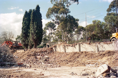
Negative - Photograph, Harry Gilham, Demolition of Eltham Shire Offices, 895 Main Road, Eltham, Aug. 1996
The Shire Offices opened in 1965 and were extended in 1971. The final Eltham Shire Council meeting was held in December 1994 before the forced amalgamations of municipal councils by the Kennett Government. The State-Government-appointed Commissioners (1994-1996) took the decision in July 1996 to demolish the Eltham Shire Offices. The demolition works started within 24 hours of the decision being made.Roll of 35mm colour negative film, 5 of 6 strips Associated colour printKodak Gold 100-5eltham shire office, demolition, shillinglaw trees -
 Lara RSL Sub Branch
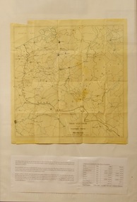
Map, Framed Map of the western front 1914-1918, Map made by G.F.Trudgion R.A.E. circa 1916
Map showing position of western front line in 1914 at the start of WW1Map is from circa 1916 showing battle area of the Western Front during WW1Map of the western front 1914-1918North West Europe Shewing the Western Front 1914-1918 War. Below is description of Australian ANZAC's on Western Front and a graph on Comparison of Casualties from Major Western Front Battlesmap, g.f.trudgion, r.a.e., western front, ww1, world war one, north west europe, 1914, 1916, ww1 casulaties -
 Ruyton Girls' School
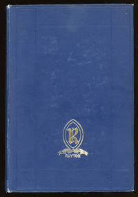
Literary work - Ruyton Prize Book, Geoffrey Cumberlege Oxford University Press, The Poetical Works of Longfellow, No date
This book contains a collection of poems written by American poet, Henry Wadsworth Longfellow. His original works include the poems "Paul Revere's Ride", "The Song of Hiawatha", and "Evangeline". He was also the first American to completely translate Dante Alighieri's Divine Comedy, and was one of the fireside poets from New England. Ruyton Girls' School has a long tradition of awarding prizes to students at annual "Speech Night" events. Speech Night at Ruyton is an extraordinary occasion. It is a time when we gather to celebrate both the year just lived and the contribution of our Year 12 girls to the life of our School. It is a night of stirring student speeches, acknowledgement of student endeavour and excellence and awe-inspiring performances by School choirs and ensembles. The record has strong historic significance as it was awarded to a former notable student, Helen Gordon (maiden name Cole). Helen started at Little Ruyton in Prep 1940 and finished Year 12 in 1952 as School Captain, Bromby Captain, Form Captain for Matric, Tennis Captain, Hockey Captain, Swimming Vice Captain, and an award for Best All-Round Girl. She also played baseball for Victoria. After finishing school, Helen went on to graduate from the University of Melbourne as a physiotherapist in 1956. Her first position at age 19 involved setting up clinics with the Victorian Health Department Poliomyelitis Rural division. Helen’s strong ties to Ruyton continued when she held the position of President of the Old Ruytonians’ Association from the start of 1966 to the end of 1967. In 2019, Helen received an Order of Australia Medal for service to community health as a physiotherapist. She was also the recipient of the 2022 Victorian Senior Achiever Award at Parliament House. Helen passed away in July 2023 at age 88. The record's significance is further enhanced by its strong provenance, having been produced by Ruyton Girls' School and donated to the Archives by a familial connection.Navy leather hardcover bound book with gold detailing on front cover and spine. 886 pages.Front Cover: R / RECTE ET FIDE LITER / RUYTON / Spine: LONGFELLOW'S / POETICAL / WORKS / OXFORD / Inside Cover: R / RECTE ET FIDE LITER / RUYTON / PRIZE / AWARDED TO / Helen Cole / FOR / Latin / Vc / H. Daniell. / 18th Dec. 1950 / Katie Alsop Memorial Prize /ruyton girls' school, school, students, prize, speech night, poetry, lord tennyson, queen victoria, senior school, high school, ruyton, old ruytonians' association -
 Bendigo Historical Society Inc.
Map - DEVONSHIRE GROUP OF MINES
Small map of Devonshire group of mines, Bendigo. Scale 8 chains to 1 Inch. Issued by M. P. Kelly sharebroker, Bendigo. Showing Hercules and Energetic, Pearl, New Victoria Catherine,, New St Mungo, xtended south devonshire, South Devonshire, United Devonshire,duchess of Edinburgh, Phoenix, South st Mungo, Lady Barkly, St. Mungo, Sadowa, Ellenborough, Williams' United, Catherine Reef United.bendigo, mining, devonshire mine -
Bendigo Historical Society Inc.
Map - BENDIGO WEEROONA GASWORKS MAP/PLAN COLLECTION: CROWN ALLOTMENTS 13/14, 1942
Map: crown allotments 13 and 14, Sec. E. City of Bendigo, Parish of Sandhurst. Shows site of Bendigo Gasworks. Prepared by Garnel Gordon Birch Surveyor, 12.6.1942map, bendigo, bendigo weeroona gas works, bendigo, gasworks, gas company, plans -
 Eltham District Historical Society Inc
Negative - Photograph, Probably Jessica's Lane, Eltham North, 1998c
Roll of 35mm colour negative film, 8 strips and associated 10 x 15 cm colour printKodak Gold 100-5eltham north, jessica's lane -
Whitehorse Historical Society Inc.
Map, Boronia Road, Vermont, 1970
Enlargement of aerial photograph of Boronia Road, Vermont. State Aerial Survey 1970 Run 37Enlargement of aerial photograph of Boronia Road, Vermont. State Aerial Survey 1970 Run 37Enlargement of aerial photograph of Boronia Road, Vermont. State Aerial Survey 1970 Run 37boronia road, vermont, lusk drive, vermont, morack road, vermont south, allison court, vermont, trinian street, vermont, cosgrove street, vermont, mawson court, vermont, aerial photographs -
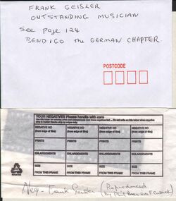 Bendigo Historical Society Inc.
Negative - GERMAN HERITAGE SOCIETY COLLECTION: NEGATIVE OF FRANK GEISLER
Small (35mm) black and white negative of Frank Geisler (Reproduced by Phil Beer via F. Cusack. Looks to be holding a musical instrument. Negative contained in an envelope with 'Frank Geisler, Outstanding Musician. See page 124, Bendigo The German Chapter' written on the front. (attempted scan of negative unsuccessful) If not in Box 480 try Box 751negative, bendigo, german heritage society, german heritage society collection - negative of frank geisler, frank cusack, phil beer -
 Eltham District Historical Society Inc
Negative - Photograph, J.A. McDonald, Upper Yarra Dam, 26 Nov. 1957
Upper Yarra Reservoir Opened by His Excellency The Governor of Victoria General Sir Dallas Brooks K.C.B.., K.C.M.G., K.C.V.O., D.S.O., K.St.J. On 26th November, 1957 This tablet also commemortyaes the centenary Of Melbourne's water supply system Yan Yean Reservoir 1857 Upper Yarra Reservoir 1957Record of various Shire of Eltham infrastructure works undertaken during the period of 1952-1962 involving bridge and road reconstruction projects, sometimes with Eltham Shire Council Project Reference numbers quoted. It was during this period that a number of significant improvements were made to roads and new bridges constructed within the shire that remain in place as of present day (2022). In many situations, the photos provide a tangible visible record of infrastructure that existed throughout the early days of the Shire. The album was put together by or under the direction of the Shire Engineer, J.A. McDonald.infrastructure, shire of eltham, 1957-11-26, opening ceremony, plaques, sir dallas brooks, upper yarra dam, upper yarra reservoir -
Whitehorse Historical Society Inc.
Map, M.M.B.W, c1962
Melbourne Metropolitan Area Base Map series sheet 235, covering part, Mitcham, Nunawading and Ringwood areas.Melbourne Metropolitan Area Base Map series sheet 235, covering part, Mitcham, Nunawading and Ringwood areas. Prepared by Department of Lands and Survey and Melbourne and Metropolitan Board of Works from State aerial Survey, June 1957 and Cadastral Survey information, August 1960. Scale 1:4,800.Melbourne Metropolitan Area Base Map series sheet 235, covering part, Mitcham, Nunawading and Ringwood areas. maps, mitcham, nunawading, ringwood, melbourne and metropolitan board of works, victoria. department of lands and survey -
 Eltham District Historical Society Inc
Negative - Photograph, Carl Walter 1831-1907, Coffer dam in the Yarra River at Anderson's Creek, 1864
1864 photograph of the Coffer Dam in the River Yarra situated (approximately) opposite Whipstick Gully. Remains of bridge built in 1860(?) wrecked by 1863 flood in background. Reproduced page 29 of ‘Pioneers & Painters’ Gold was first discovered in this area at Andersons Creek (Warrandyte) in June 1851 by Louis Michel. Discoveries north of the Yarra did not occur until about 1854. Although it took some months for a true rush to develop it was not long before alluvial workings were being carried on in most of the Shire of Eltham. The last area in which gold was discovered was Kinglake. As the gold became harder to find, deep mining took over from alluvial diggings in the gullies. Perhaps the most extensive of the deep workings was the Diamond Creek Mine just outside the boundary of the Shire. This form of mining was continued into the 1930s. There are believed to be some mines in the area still capable of producing gold but present prices make working these uneconomical. Some gold is still found by weekend prospectors. Photo: Carl Walter 1831-1907 – inscribed on tent “C. Walter Photo” The State Library of Victoria holds over 150 photos by Carl Walter, most of which are portraits of Aboriginal natives including William Barak.This photo forms part of a collection of photographs gathered by the Shire of Eltham for their centenary project book,"Pioneers and Painters: 100 years of the Shire of Eltham" by Alan Marshall (1971). The collection of over 500 images is held in partnership between Eltham District Historical Society and Yarra Plenty Regional Library (Eltham Library) and is now formally known as 'The Shire of Eltham Pioneers Photograph Collection.' It is significant in being the first community sourced collection representing the places and people of the Shire's first one hundred years.Digital image 4 x 5 inch B&W Neg (2) Print 20 x 25 cmshire of eltham pioneers photograph collection, anderson's creek, coffer dam, floods, gold mining, other areas, pioneers and painters, warrandyte, warrandyte bridge, yarra river -
Bendigo Historical Society Inc.
Map - CROSBIE, 26/09/1878
Map: Crosbie, County of Rodney. Parish plan (number 260 in map cupboard 1)map, rodney, parish plan, crosbie, county of rodney -
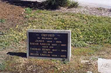 Eltham District Historical Society Inc
Negative - Photograph, Harry Gilham, Orford family graves, Eltham Cemetery, Victoria, Sep 2009
One of Eltham's earliest settlers was James Orford. Born 1804 in Bedfordshire, the son of George, a carpenter and Lydia Barret, he and wife Sarah Amelia nee Moull (1807) arrived as Assisted Immigrants aboard the ship, ‘Orestes’, November 28, 1839 accompanied by their children, George (14), Mary Ann (11), and James (2). Originally settling in New South Wales, daughter Sarah Amelia was born at Braidwood in 1843 and son, Thomas Henry at Pambula in 1847. James was a carpenter who is known to have built the original gates to Eltham Cemetery. He died in 1869. Around 1890, his son Thomas Henry Orford was living in Pitt Street. Following the death of his wife Helen in 1899, Thomas was appointed by Joseph Panton to look after ‘Panton Park’, a 429-acre bushland property at the fork of Reynolds and Laughing Waters Roads, extending down to the Yarra River. His work entailed ringbarking the manna gums on the property to clear the land for pasture. Thomas lived in a slab hut with his son Ernie, who helped with the work. When Gordon Lyon purchased Panton Park in 1908, Thomas then worked for Lyon at both Panton Park and at ‘Banyule’, Lyon's stud farm at Heidelberg. In 1915 Lyon gave Thomas six acres of land in Reynolds Road with a two-roomed cottage. Thomas died in 1944 and is buried in Eltham Cemetery with his wife and his parents. Another of James Orford's sons was James Matthias Orford. He tried to grow food on land at the end of Laughing Waters Road, but without success. Reputedly the Wurundjeri taught him to swim. He was once imprisoned; when his friend Constable Lawlor invited him to inspect the new bluestone lock-up, Lawlor locked him in and wouldn't release him until he was promised two gallons of beer! ORFORD In Memory Of James 1804 -1869 Sarah Amelia 1807 - 1897 Their son Thomas Henry 1847 - 1944 His wife Helen Amelia 1854 - 1899Roll of 35mm colour negative film, 6 stripsKodak GC 400-9eltham cemetery, gravestones, helen amelia orford, james orford, sarah amelia orford, thomas henry orford, cemetery gates -
Stawell Historical Society Inc
Map, Parish of Stawell, Sheet 1
Parish of Stawell, Sheet 1stawell -
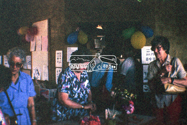 Eltham District Historical Society Inc
Negative - Photograph, Open Day, Eltham Living and Learning Centre, 7 Nov 1987
Open Day, Eltham Living and Learning Centre, part of the Eltham Community Festival activites, 7 Nov. 1987eltham, eltham festival, eltham living and learning centre, living and learning centre, open day -
Whitehorse Historical Society Inc.
Map, Melbourne and Metropolitan Board of Works, 1925
1925 plan of the Yan Yean, Maroondah and O'Shannassy water supply systems.1925 plan of the Yan Yean, Maroondah and O'Shannassy water supply systems.1925 plan of the Yan Yean, Maroondah and O'Shannassy water supply systems.water supply, melbourne and metropolitan board of works -
 Kew Historical Society Inc
Map - Subdivision Plan, Grenville Estate, 1922
Pru Sanderson, in her groundbreaking ‘City of Kew Urban Conservation Study : Volume 2 - Development History’ (1988), summarised the periods of urban development and subdivisions of land in Kew. The periods that she identified included 1845-1880, 1880-1893, 1893-1921, 1921-1933, 1933-1943, and Post-War Development. These periods were selected as they represented periods of rapid growth or decline in urban development. An obvious starting point for Sanderson’s groupings involved population growth and the associated economic cycles. These cycles also highlighted urban expansion onto land that was predominantly rural, although in other cases it represented the decline and breakup of large estates. A number of the plans in the Kew Historical Society’s collection can also be found in other collections, such as those of the State Library of Victoria and the Boroondara Library Service. A number are however unique to the collection.Subdivision plans are historically important documents used as evidence of the growth of suburbs in Australia. They frequently provide information about when the land was sold on which a built structure was subsequently constructed as well as evidence relating to surveyors and real estate and financial agents. The numerous subdivision plans in the Kew Historical Society's collection represent working documents, ranging from the initial sketches made in planning a subdivision to printed plans on which auctioneers or agents listed the prices for which individual lots were sold. In a number of cases, the reverse of a subdivision plan in the collection includes a photograph of a house that was also for sale by the agent. These photographs provide significant heritage information relating house design and decoration, fencing and household gardens.In advertising the twenty-two sites of the Grenville Estate in Cotham Road and Alfred Street, Kew, the auctioneers emphasised the proximity of the development to shops, schools, and churches. That mansions surrounded the Estate was publicised as an added attraction. The plan shows how at this stage A regrettable aspect of this plan is that it is pasted over, and obscures a real estate photograph by the Kew photographer Josiah Earl Barnes.subdivision plans - kew, grenville estate, glenferrie road, alfred street, thomas street, cotham road -
 Bendigo Historical Society Inc.
Map - FORTUNA HUSTLER'S MINE - LONGITUDINAL SECTION OF THE FORTUNA HUSTLER'S MINE
Longitudinal Section of the Fortuna Hustler's Mine on the Hustler's Line of Reef, Bendigo. Bulletin No 33, Plate No IV. Shows poppet legs at the surface level, Datum Line 750 feet above Sea Level, levels and their depths, the amount of gold per ton and some geographical features. Geological Survey of Victoria emblem and signed by H A Whitelaw, Underground Survey Office, Bendigo. Note - Plates 4, 8, 13, 20, 26 & 31 form a Longitudinal Section from Fortuna Hustler's to Hustler's Consols Mine. This item has not been scanned or photographed.mining, parish map, fortuna hustler's mine, longitudinal section of the fortuna hustler's mine, geological survey of victoria, h a whitelaw, underground survey office bendigo, hustler's line of reef, hustler's consols mine -
 Bendigo Historical Society Inc.
Negative - 'MARYDALE' AXEDALE COLLECTION: NEGATIVES
Negatives of 4 of the 14 photos in the Marydale Axedale Collection. The negatives are in an envelopeaxedale, history, marydale property -
Port Melbourne Historical & Preservation Society
Map - Road plans for Fishermens Bend, R S Atkinson, 30 Apr 1946
CRB Map outlining road plans for Fishermens Bend and including the site of the Commonwealth Aircraft Corporation, Aerodrome, General Holdens and C.S.R.I., 1946transport - aviation and aerodrome, industry - manufacturing, fishermans bend -
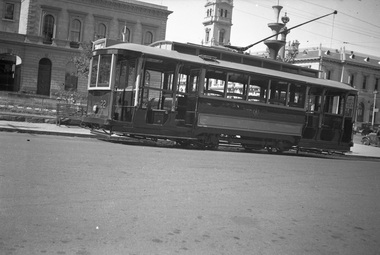 Ballarat Tramway Museum
Negative, Wal Jack, 1938
Yields information about Ballarat 's No. 22 during 1938Set of two Negative and Digital images of the Wal Jack Ballarat Negative file of No. 22 in Sturt St at the corner of Lydiard St with the Post Office in the background, photograph during the Centennial celebrations of 1938, given the decorations in the background. Tram has the destination of Gardens via Sturt St West. Note the decorations in the for the centenary of settlement in the Ballarat district in 1938 - see Reg Item 5906 Two copies of the negatives on file.trams, tramways, sturt st, centenary, tram 22 -
Stawell Historical Society Inc
Map, Township of Moyston, Parish of Moyston, County of Borung, 1956
Township of Moyston, Parish of Moyston, County of Borungstawell -
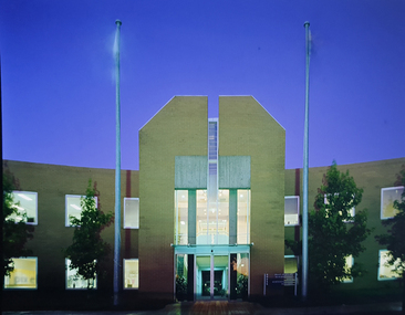 Federation University Historical Collection
Negative, Mt Helen Campus Administration Building
Colour photograph of the Mt Helen Campus Administration Building, with flags flying. mt helen campus, buildings, administration building, d building, flags, flagpole -
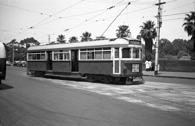 Melbourne Tram Museum
Negative, Wal Jack, 1939
Black and white negative by Wal Jack of SW6 850 (Prahran, route 77), leaving the Batman Ave terminus at Princes Bridge. Has tail lights and dash canopy lighting with the sign "This is you car use it" underneath. The front number can just be seen. Note the parked taxis and drivers on the south side of the roadway. See also Reg Item 5244 for a photo of the tram at the terminus.trams, tramways, princes bridge, sw6 class, dash canopy lights, new tramcars, batman ave, tram 850 -
Glenelg Shire Council Cultural Collection
Negative - Negative -Donovan's Landing Nelson, Victoria, c. 1936
Negative for a black and white photograph. Image shows Donovan's landing, Nelson Victoria. Group of 7 people standing on a small landing, river, boat sheds in background. -
Port Melbourne Historical & Preservation Society
Map - MHT General Plan showing Harbour improvements recommended Sir John Coode, Thomas Kell Lith, 1800s
Black and white map "Melbourne Harbour Trust, General Plan showing Harbour improvements, as recommended by Sir John Coode in his report of 17th February 1879" Showing proposed Coode canal and Sandridge, Hobson's Bay, North Williamstown, Footscray, the City, Emerald Hill and also the buildings of "Kitchen and Son" . (copy of original)industry, manufacturing, engineering department, borough of sandridge, engineering - canals and drainage, melbourne harbor trust - port of melbourne authority, j kitchen & sons pty ltd, sir john coode -
Glen Eira Historical Society
Map - Gardenvale Road, 11, Caulfield South
A one page typed letter from Equity Trustees to S P Simmonds Estate Agent, dated 12/12/1963, requesting a valuation of the property at 11 Gardenvale Road, Caulfield South. The file also includes a three page typed valuation of the property dated 19/12/1963. It provides details of the property and includes a hand drawn plan (75mm x 100mm) showing measurements of the block. The file also includes one page of undated, unattributed, handwritten working notes for the purpose of the valuation.redapple r r, redapple joseph, redapple rebecca rachel, gardenvale road, caulfield south, land values, brick houses -
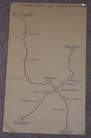 Ballarat Tramway Museum
Map, "Bendigo Tramway Routes and Section Destinations", c1970
Demonstrates the layout of the Bendigo tramways, extracted from the Fare Schedule. Basis of production, source unknown. Associated with Eildon Hogan.Plastic coated, card mounted map showing diagrammatic routes of map of Bendigo routes, extracted from the SEC Fare Schedule.trams, tramways, bendigo, map -
Stawell Historical Society Inc
Map, Ledcourt, County of Borung, Shire of Stawell, 1957
Ledcourt, County of Borung, Shire of Stawellstawell -
Bendigo Historical Society Inc.
Map - NEILBOROUGH, 27/09/1904
Map: Neilborough, County of Bendigo. Parish planmap, bendigo, parish plan, neilborough