Showing 5696 items
matching documentation
-
 Port Melbourne Historical & Preservation Society
Plan - Sounding at Station Pier, Port Melbourne, Engineering Division, Port of Melbourne Authority, May 1985
Plan - Sounding at Station Pier taken May/June 1985.melbourne harbor trust - port of melbourne authority -
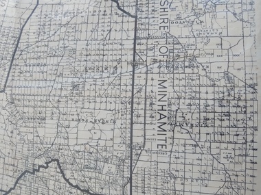
Bendigo Historical Society Inc.
Map - PARISH OF RAVENSWOOD, 3/04/1875
Map: Parish of Ravenswood, Counties of Bendigo and Talbot. Parish planmap, bendigo, parish plan, ravenswood, county of talbot, county of bendigo -
Bendigo Historical Society Inc.
Map - BENDIGO, October 1st 1893
Map: Plan of the whole County of Bendigo, Showing areas now available for Selection (number 340 in map cupboard 1)map, bendigo, lands for selection, county of bendigo, areas available for selection -
Glenelg Shire Council Cultural Collection
Plan - Plan - Portland Sewerage Association, n.d
Portland Sewerage Authority Plan of Drainage for Mrs M Campbellcampbell family records -
Stawell Historical Society Inc
Map, Great Western, Parish of Concongella, County of Borung, 1958
Great Western, Parish of Concongella, County of Borungstawell -
Moorabbin Air Museum
Plan (item) - C.A.C Flywheel Power Unit
EX250012 -
 Peterborough History Group
Map - Shire of Warrnambool
Map of the area, when Peterborough was part of Warrnambool ShireHistoric map of the area when Peterborough was in the Warrnambool ShireA3 size map, larger view of the whole shire of Warrnambool, and includes adjoining Shire Boundaries. Shows individual land allotments.peterborough, warrnambool shire, old maps -
Clunes Museum
Map - CLUNES TOWN HALL AND COURTHOUSE COMPLEX, FALKINGER ANDRONAS
CLUNES TOWN HALL AND COURT HOUSE COMPLEX - PROPOSED REFURBISHMENT ARCHITECT DRAWINGS: ,1 SITE AND ROOF PLAN .2 GROUND FLOOR PLAN .3 EAST ELEVATION .4 WEST ELEVATION .5 ABC/FASSADEStown hall and courthouse drawings, proposed refurbishment -
Glenelg Shire Council Cultural Collection
Map - Map - RACV Portland District Map, Portland, Victoria & Mt Gambier, South Australia, c. 1970
RACV map, black and white tri-fold, photo of Cape Nelson lighthouse on front. When unfolded, map of Portland District on one side, map of Portland and Mt. Gambier on the other, together, with short description and a list of points of interest -
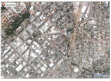 Bendigo Historical Society Inc.
Map - BENDIGO MAP AERIAL VIEW
Map of Bendigo. Aerial View of Bendigo. Published by City of Bendigo. Undated.photograph, aerial, bendigo -
Bendigo Historical Society Inc.
Map - YALLOOK, 25/02/1876
Map: Parish of Yallook, County of Bendigo. Parish plan. Map dated 25/02/1876.map, bendigo, parish plan, yallook -
Glenelg Shire Council Cultural Collection
Plan - Ship Plan / Mould, n.d
Wooden pattern for mould for boat fitting. Boomerang shaped flat base, strip of ply wood attached at right angles to base, with copper nails, shaped block attached to underside of base with copper nails. Top painted cream, underside unpainted. -
Bendigo Historical Society Inc.
Map - CAMPBELL COLLECTION: BENDIGO AND DISTRICT MAPS
Map. Mandurang, Parish of Mandurang. Scale 20 chains to 1 inch. Total area 5993 acres. Northern Railway. (number 395 in map cupboard 1)map, bendigo, allotments -
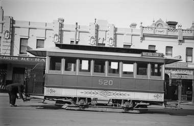 Melbourne Tram Museum
Negative, Ellis Collection, c1940?
Negative (120) of a cable saloon car 520 outside the Railway Hotel 800 Nicholson St Fitzroy. The tramcar has the destination of Nicholson St and has an unusual (rare) decorative panel on the lower side. The Railway Hotel remains active. The letters "RA" can be seen on the left hand side of the car. Next door is newsagent selling The Argus and the Sporting Globe. A low resolution A4 laminated was received with the negatives. Hi Res image filed in the dbtext/hawthtramcoll/Large Images/htd3591large.jpgtrams, tramways, cable trams, nicholson st, fitzroy, hotels, tram 530 -
Whitehorse Historical Society Inc.
Map, Map of Vermont area, c1895
Photocopy of part of a larger map showing the Vermont area.Photocopy of part of a larger map showing the Vermont area. Note on side 'after 1892'. Shows land holders.Photocopy of part of a larger map showing the Vermont area.maps, vermont -
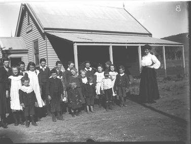 Wodonga & District Historical Society Inc
Negative - Haeusler Glass Negatives Collection - Teachers and Students Wodonga West Primary School, c1910
The Wodonga Historical Society Haeusler Collection provides invaluable insight into life in late nineteenth and early twentieth century north east Victoria. The collection comprises manuscripts, personal artefacts used by the Haeusler family on their farm in Wodonga, and a set of glass negatives which offer a unique visual snapshot of the domestic and social lives of the Haeusler family and local Wodonga community. The Haeusler family migrated from Prussia (Germany) to South Australia in the 1840s and 1850s, before purchasing 100 acres of Crown Land made available under the Victorian Lands Act 1862 (also known as ‘Duffy’s Land Act’) in 1866 in what is now Wodonga West. The Haeusler family were one of several German families to migrate from South Australia to Wodonga in the 1860s. This digital image was produced from one of the glass negatives that form part of the collection, probably taken by Louis Haeusler (b.1887) with the photographic equipment in the Wodonga Historical Society Haeusler Collection. This item is unique and has well documented provenance and a known owner. It forms part of a significant and representative historical collection which reflects the local history of Wodonga. It contributes to our understanding of domestic and family life in early twentieth century Wodonga, as well as providing interpretative capacity for themes including local history and social history.Digital image created from the Haeusler Glass negative collection. A group of students with their teacher standing outside their school building at Wodonga West, Victoria No. 1058. The school was located near the current intersection of McKoy Street and the Hume Freeway in West Wodonga on land donated by J.W. Klinge, replacing an older school north of the railway line. It operated from January 1870 to May 1950 when the nine remaining students transferred to Wodonga Primary School.wodonga pioneers, haeusler family, glass negatives, dry plate photography, wodonga west primary school -
 Kew Historical Society Inc
Plan - Subdivision Plan, Raheen Estate Subdivision, 1960
Subdivision plans are historically important documents used as evidence of the growth of suburbs in Australia. They frequently provide information about when the land was sold on which a built structure was subsequently constructed as well as evidence relating to surveyors and real estate and financial agents. The numerous subdivision plans in the Kew Historical Society's collection represent working documents, ranging from the initial sketches made in planning a subdivision to printed plans on which auctioneers or agents listed the prices for which individual lots were sold. In a number of cases, the reverse of a subdivision plan in the collection includes a photograph of a house that was also for sale by the agent. These photographs provide significant heritage information relating house design and decoration, fencing and household gardens.The Raheen Estate Subdivision of 1960 involved the creation of 36 residential allotments and the sale of 34 of these. The land on which the subdivision was created had until 1960 formed part of the grounds of the mansion Raheen in Studley Park Road. In 1917, the Catholic Church had purchased Raheen and its lands. It was to become the home of Archbishop of Melbourne, Daniel Mannix, for 46 years. The sale of the subdivision took place three years before the Archbishop’s death. Subsequent archbishops were to reside at Raheen until its sale to the Pratt family in 1981. When the sale of the Estate was reported in the newspapers in 1960, it was described as the last big subdivision near Melbourne. At the auction, 33 of the 36 allotments were sold. The auction realised £315,750. Purchasers were advised that the vendor intended to keep lots 22 and 23. The alllotments in the subdivision required the construction of new roads. These included Eamon Court and Raheen Drive. The justification provided by the Church for the sale was that the estate was being sold to finance school building projects.subdivision plans - kew, studley park, raheen estate, eamon court, studley park road, coombes avenue, raheen drive -
Bendigo Historical Society Inc.
Map - MANDURANG, 8/10/1887
Parish of Mandurang, County of Bendigo. Traced from a re-survey of the Parish of Mandurang by Mr. Geo. Black 8/10.1887 ( number 158 in Map Cupboard 1)map, bendigo, parish plan, mandurang, re-survey, couny of bendigo -
 Bendigo Historical Society Inc.
Negative - BENDIGO CHINESE TEA HOUSE
Construction of the Bendigo Chinese Tea House, Nolan Street, Bendigo.buildings, commercial, tea house -
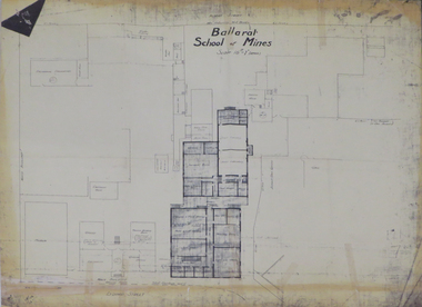 Federation University Historical Collection
Plan, Ballarat School of Mines 'Old Chemistry Building' Plan
Ballarat School of Mines is a predecessor institution of Federation University Australia. Two plans showing the Ballarat School of Mines Old chemistry Building and the Ballarat Technical Art School Building. It also shows the location of the Ballarat School of Mines Model Mine, Battery House, etc.ballarat school of mines, model mine, battery, old chemistry building, ballarat technical art school, laboratory, plan, architectural plans -
Port Melbourne Historical & Preservation Society
Plan, C Allen and A Tuxen, Suveyors, Plans and Sections of Tramways MTOC 1882, 1882
Large, hard-bound set of plans for tramway development (Williamstown to Melbourne under the Yarra via Port Melbourne) presented to the 1882 Victorian Leg. Council. Blue-black with gold-stamped maroon title panel.Signed by the Engineer and the Parliamentary Agent.melbourne tramway and omnibus company, transport - tramways -
 Whitehorse Historical Society Inc.
Map, Shire of Nunawading 1888
Plan showing owners of land in the South Riding of the Shire of Nunawading, 1888. South Boundary Road is now Highbury Road.shire of nunawading. south riding, south boundary road, burwood east, highbury road, springvale road, mahoneys road, forest hill, holland road, blackburn south, burwood highway -
Port Melbourne Historical & Preservation Society
Plan - Bow Fender, Inner East berth, Ferry Terminal, Station Pier, Port Melbourne, Port of Melbourne Authority, 1984
Plan - general arrangement of Bow Fender Station Pier - Inner East - Ferry Terminal - preliminary print only.melbourne harbor trust - port of melbourne authority, piers and wharves - station pier -
Federation University Historical Collection
Plan, Ballarat East Longitudinal Section, not dated
Printed plan of Ballarat East showing pitch of quartz veins and crosscourses Sheet No 2plan, ballarat east, longitudinal section, mining -
 Bendigo Historical Society Inc.
Negative - TOM PATULLO COLLECTION: MARKET BUILDINGS
Negative print, Market Buildings. Castlemaine Councillors and others in front of the building, who are from left; Gibson, Tracy, Burnett, Slee, Christopher, Cr.Mitchell, Cr.Cooper, Cr. G.W.Greenhill, Cr.Dunstan, Holmes, Cr.McGregor, Cr.Pierce, Cornish.cottage, miners, market buildings., castlemaine-market buildings.-councillors -
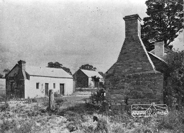 Eltham District Historical Society Inc
Negative - Photograph, Home Beautiful (United Press), Thomas Sweeney's original cottage at Culla Hill, Eltham, 1940
Feature article in Home Beautiful magazine (c.1940) on the original Sweeney's Cottage at Culla Hill built by Thomas Sweeney, one of the district's pioneer settlersRoll of 35mm black and white negative film, 3 stripsKodak Safety 5062culla hill, eltham, home beautiful magazine, houses, sweeney's cottage, sweeneys lane, thomas sweeney -
Stawell Historical Society Inc
Map, Shire of Stawell, Shire of Stawell Interim development Order, C 1930
Planning MapColoured Map of Stawell Shire showing Zoning AreasGuttering Haskings & Davey Pty Ltd Division of Urban and Environmental Planninglocal development -
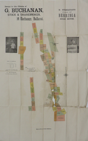 Federation University Historical Collection
Plan, G. Buchanan's Plan of the Berringa Gold Mines, 1866?
This plan is associated with former Ballarat School of Mines student Richard Squire (1875-1876) Gift of the Squire FamilyColoured plan of the Berringa Goldmines.squire, richard squire, berringa, g. buchanan, buchanan, stockbroker, birthday freehold, f. holst, holst, staffordshire reef, williams fancy, kangaroo, moonlight, cgt, staffordshire reef township, w. prie, northern birthday, a clinton, birthday star, a. lamb -
Port Melbourne Historical & Preservation Society
Plan - Proposed railway along Howe Parade to Webb Dock, 1973
Plan of proposed railway along Howe Parade to Webb Dock 1973R.C.B. drawing no 7931piers and wharves - webb dock, perce mcguire white, perce white -
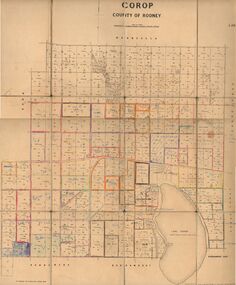 Bendigo Historical Society Inc.
Map - JACK FLYNN COLLECTION: COROP, 8/08/1929
Map: Corop, County of Rodney. Parish plan.By Authority H. J. Green, Govt. Printer, Melb. Dept of Lands and Survey Melbourne by Price 8.8.29map, rodney, parish plan, corop, county of rodney