Showing 2189 items
matching documentation
-
 Bendigo Historical Society Inc.
Map - MINE LOCATION DRAWING AT VICTORIA HILL
Claims and shafts location for: Rae and co. - Noye and co. - Wittscheibe. Some additions to drawing made in pencil.mining, business -
Whitehorse Historical Society Inc.
Map, Aerial photographs Nunawading, 1972
Department of Crown Lands and Survey, Melbourne, 1972.Department of Crown Lands and Survey, Melbourne, 1972. Project runs 34 - 39 - City of Nunawading. frames numbered from South to North boundaries, each strip numbered from West to east. The series extends further West to Box Hill and East to Ringwood than the 1970 project. No index map. Sheets 39/2 and 34/28 missing.non-fictionDepartment of Crown Lands and Survey, Melbourne, 1972.victoria. department of crown lands and survey, aerial photographs, nunawading, mitcham, blackburn, blackburn north, blackburn south, forest hill, vermont, burwood east, box hill, ringwood, vermont south -
 National Vietnam Veterans Museum (NVVM)
Map, Relief Map of Vietnam
Detailed relief map with words XA BIN BA + XUYEN MOC titled on information heading. Map information listed on lower portion.relief map, vietnam -
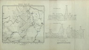 Federation University Historical Collection
Map, Geological Sketch Map of of Dundas, Berung, and Ripon Counties
Map of the Counties of Dundas, Berung, and Riponcounty of dundas, county of berung, county of ripon, map, geology, ararat, stawell, hamilton, grampians -
Bendigo Historical Society Inc.
Map - ELLESMERE, COUNTY BENDIGO, 17-3-16
Map, Ellesmere, County Bendigo, Goornong, Bagshot, Muskerry, Wellsford, Axedale, Township of Fosterville.Campaspe River, Bendigo Creek, Railway Line.Photographed at the Dept. of Lands and Survey, Melbourne by W.J.Butson 17-3-16.Price 1/-. By authority Albert J.Mullett, Government Printer, Melbourne. ( number 38 in Map Cupboard 1)Albert J.Mullett, Govt. Printer, Melbourne.map, bendigo, ellesmere -
Bendigo Historical Society Inc.
Map - BAMAWM : COUNTY OF BENDIGO, November 1954
Map. Bamawm, County of Bendigo, Pannoobamawm, Turrumberry, Millewa, Ballendella. By authority W.M. Houston, Government Printer. Drawn and reproduced at the Dept of Lands and Survey,Melbourne, Victoria. November 1954. Price 5/- per sheet. (number 51 in map cupboard 1)W.M. Houston, Govt. Printermap, bendigo, bamawm -
University of Melbourne, Burnley Campus Archives
Map, City of Kew, Hyde Park, c. 1970
(1) Photocopy of hand drawn plan of park showing contours. No 7/3. Scale 1 inch:40 ft. (2) Map 45 from Melway with Hyde Park highlighted.kew, hyde park -
Whitehorse Historical Society Inc.
Map, Campbell's Croft, c1970
Enlarged aerial photograph of the area around Campbell's Croft Reserve. State aerial Survey, Melbourne, 1970 project. Run 37Enlarged aerial photograph of the area around Campbell's Croft Reserve. State aerial Survey, Melbourne, 1970 project. Run 37Enlarged aerial photograph of the area around Campbell's Croft Reserve. State aerial Survey, Melbourne, 1970 project. Run 37campbells croft, boronia road, vermont, madonna court, vermont, aerial photographs -
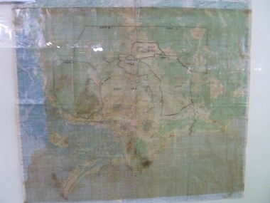
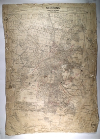 Bendigo Historical Society Inc.
Map - NERRING, 25/08/1903 ?
Map: Parish of Nerring, County of Bendigo. Parish plan Canvas backedmap, bendigo, rural, nerring, county of bendigo -
Bendigo Historical Society Inc.
Map - DARGILE : COUNTY OF BENDIGO, November 1953
Map. Dargile, County of Bendigo, County of Rodney, Cornella Creek, Northern Highway, Crosbie, Redcastle, Knowsley East, Heathcote, Costerfield, Moormbool West. By authority W.M. Houston, Government Printer. Drawn and reproduced at the Department of Lands and Survey, Melbourne. November 1953. Price 2/-. (number 115 in map cupboard 1)W.M Houston, Government Printermap, bendigo, dargile -
Port Melbourne Historical & Preservation Society
Map, G S Williams, City Engineer, City of Port Melbourne, Dec 1963
Map of City of Port Melbourne (brick areas marked in colour), 1963.G. S. Williams (City Engineer)town planning, g s williams, troedel and cooper -
Whitehorse Historical Society Inc.
Map, Map, Parish of Nunawading, 1850's
A basic map of the Parish of Nunawading to which additions have been made. Scale 70 chains:3.5 inchesA basic map of the Parish of Nunawading to which additions have been made. Scale 70 chains:3.5 inchesmaps, parish of nunawading -
Stawell Historical Society Inc
Map, Special Allotments, Reefs, Pleasant Creek
Special Allotments, Reefs, Pleasant Creekstawell -
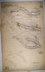
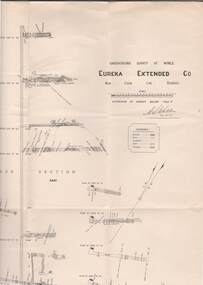 Bendigo Historical Society Inc.
Map - STRUGNELL COLLECTION: UNDERGROUND SURVEY OF MINES, BENDIGO, 29-4-01
Map, Underground Survey of Mines, Bendigo.Eureka Extended Co., New Chum Line. Signed H.A.Whitelaw 29.4.01 Drawing shows mine shaft from 1871 feet to over 3030 feet deep and appears to show samples of connecting horizontal shafts with their respective mineral contents.A>S>Whitelawmap, bendigo, eureka extended co. -
Whitehorse Historical Society Inc.
Map, Heritage overlay map, 1/02/1999 12:00:00 AM
City of Whitehorse heritage review : Heritage overlay map.City of Whitehorse heritage review : Heritage overlay map.City of Whitehorse heritage review : Heritage overlay map.city of whitehorse, historic buildings, blackburn, blackburn south, blackburn north, mitcham, nunawading, forest hill, vermont, vermont south, burwood east -
Bendigo Historical Society Inc.
Map - HUSTLER'S ROYAL RESERVE NO 2 CO. - LONGITUDINAL SECTION OF THE HUSTLER'S ROYAL RESERVE NO 2 CO
Longitudinal Section of the Hustler's Royal Reserve No 2 Co. on the Hustler's Line of Reef Bulletin No 33, Plate No VIII. Note - Plates 4, 8, 13, 20, 26 & 31 form a Longutudinal Section from Fortuna Hustler's to Hustler's Consols Mine. Mines mentioned are the Hustler's Royal Reserve No 2 Main Shaft, Hustler's Royal Reserve No 2 Park Shaft, Royal Hustler's, Imperial Hustler's, Great Extended Hustler's Freehold and the Great Extended. Section shows depth of levels, datum lines and height of sill above sea levelyield in ozs od gold. Geological Survey of Victoria emblem. H. Herman, Director, W. Dickson, Secretary for Mines and The Hon. J. Drysdale Brown MLC, Minister for Mines and signed by H S Whitelaw, Underground Survey Office Bendigo, September 1913. This item has not been scanned or photographed.mining, parish map, hustler's royal reserve no 2, longitudinal section of the hustler's royal reserve no 2 co, hustler's royal reserve no 2 (main shaft), hustler's royal reserve no 2 (park shaft), royal hustler's, imperial hustler's, great extended hustler's freehold, great extended, geological survey of victoria, underground survey office bendigo, h s whitelaw, h herman, w dickson, the hon j drysdale brown -
Stawell Historical Society Inc
Map - Laminated Map, Country Fire Authority, Mt Lubra and Deep Lead Fires Estimated Perimeters 2005 - 2006, 17/3/2006
Huge Fire Event in Grampians started by lightning strike at Mt Lubra on 19/1/2026 during a prolonged dry period. Stawell Deep Lead fire 31/12/2005 just three weeks earlier. Two people died on Moyston / Pomonal Road. Huge stork and feed loss.Coloured Laminated Map of Fire SpreadCFA GIS Services Community Safety -
Whitehorse Historical Society Inc.
Map, Eastern Freeway, n.d
Map of proposed Eastern Freeway, Mitcham - Ringwood.Map of proposed Eastern Freeway, Mitcham - Ringwood.Map of proposed Eastern Freeway, Mitcham - Ringwood.freeways, eastern freeway, mullum mullum creek -
Bendigo Historical Society Inc.
Map - TOOLLEEN : COUNTY OF BENDIGO, 25-5-26
Map. Toolleen, County of Bendigo, County of Rodney, Campaspe, Colbinabbin, Cornella, Crosbie, Muskerry, Mount Pleasant Creek, Township of Toolleen. By authority H.J. Green, Govt. Printer. Photo-Lithographed at the Department of Lands and Survey, Melbourne by W.J. Butson, 25-5-26. (number 105 in map cupboard 1)H.J. Green, Govt. Printer.map, bendigo, toolleen -
 Bendigo Historical Society Inc.
Map - BOROUGH OF EAGLEHAWK SHEET 3, Circa 1880's
Map: Borough of Eaglehawk , sheet No. 3. Parish planmap, bendigo, parish plan, `borough of eaglhawk -
Bendigo Historical Society Inc.
Map - EGERTON, 13/05/1879
Map: Egerton, County of Bendigo. Parish plan ( number 236 in Map Cupboard 1)map, bendigo, parish plan, egerton -
Bendigo Historical Society Inc.
Map - EGERTON, 28/01/1896
Map: Parish of Egerton, County of Bendigo. Parish plan. (number 335 in map cupboard 1)map, bendigo, parish plan, egerton -
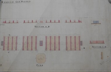 Bendigo Historical Society Inc.
Map - BENDIGO WEEROONA GASWORKS MAP/PLAN COLLECTION: SECTION OF BENDIGO GASWORK, 1889
Plan: showing section of Bendigo Gasworks, Hand coloured plan. Dated December 18th. , 1889...? Thompson, Dec. 18th., 1889bendigo, gasworks, plan. -
Bendigo Historical Society Inc.
Map - LANGWORNOR, 17/07/1942
Map: Langwornor, County of Dalhousie. Parish Plan, coloured ( number 165 in Map Cupboard 1)map, dalhousie, parish plan, langwornor, county of dalhousie -
 Ballarat Tramway Museum
Map, Australian Survey Corps, "Victoria Ballan", 1933
Topographic map of the Ballan area - includes Bacchus Marsh and Bungaree, No. 837, Zone 7, Army Map, dated 1933, 1:63360. Shows rail lines, roads, elevations, contours. Collected with relevance to the Museum's association with the area, at Bungareetrams, tramways, bungaree, map -
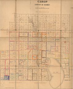 Bendigo Historical Society Inc.
Map - JACK FLYNN COLLECTION: COROP, 8/08/1929
Map: Corop, County of Rodney. Parish plan.By Authority H. J. Green, Govt. Printer, Melb. Dept of Lands and Survey Melbourne by Price 8.8.29map, rodney, parish plan, corop, county of rodney -
Bendigo Historical Society Inc.
Map - MANDURANG 2, March 194-?
Map: Mandurang 2, County of Bendigo. Parish plan (number 296 in map cupboard 1)map, bendigo, parish plan, mandurang -
Moorabbin Air Museum
Map (Item) - Includes details of BHP properties, Newcastle Australia map
-
Whitehorse Historical Society Inc.
Map, Broadbents map no 230, To and from Clifford Park, c1955
Map - To and From Clifford Park by Broadbents 1955 - 56 prepared for a scout jamboree.maps, eastern suburbs (melbourne), scout groups -
Whitehorse Historical Society Inc.
Map, City of Nunawading, c1980
Map of the City of Nunawading with list and location of 47 schools.Map of the City of Nunawading with list and location of 47 schools. Scale 1 mile = 3.75 inMap of the City of Nunawading with list and location of 47 schools. city of nunawading, maps, schools