Showing 2404 items in the category Documentation with item type Map
-
 Whitehorse Historical Society Inc.
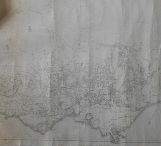
Map - WW1 Trench map, Belgium collected by C H Honybun, Belgium WW1 map, Aug 1917
WW1 map of Belgium Edition 1. Sheet 28 S.W. and S.E. with trenches in red around the towns of Comines and Warnetonnon-fictionWW1 map of Belgium Edition 1. Sheet 28 S.W. and S.E. with trenches in red around the towns of Comines and Warnetonworld war 1914 - 1918, maps -
Stawell Historical Society Inc
Map, Jallukar, County of Borung, 1971
Jallukar, County of Borungstawell -
 Kew Historical Society Inc
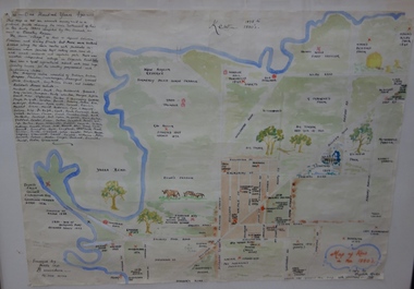
Map, Elizabeth Mackie, Kew 1875-1880s, c. 1985
Elizabeth Mackie was a member of the Kew Historical Society and a resident of 1 Molesworth Street. She researched and wrote the booklet 'Artists of Kew' and initiated research into authors with a connection to Kew. One of the most important maps of Kew in the KHS Collection is 'Back to Kew' created by Jesse Dannock. This water damaged map was in many places unreadable, and this re-creation by Elizabeth Mackie only included part of the original text. It was also liberally added to with pictorial symbols.A reinterpretation of the Back to Kew 1875 map created by Jesse Dannock in circa 1931. This hand-drawn map was created by Elizabeth Mackie in the 1980s.elizabeth mackie, plan of kew, maps -- kew (vic.), jesse dannock -
Bendigo Historical Society Inc.
Map - HARCOURT : COUNTY OF BENDIGO, 23-3-10
Map. County of Bendigo, County of Talbot, Sutton Grange, Ravenswood, Walmer, Faraday, Castlemaine, Axe Creek, Barkers Creek, Melbourne to Echuca Railway, Victorian Water Supply in Connection with Barkers Creek Reservoir. Victorian Water Supply Reserve, Mt. Alexander State Forest. Three areas reserved for Sericulture (Silkworms). Photo-Lithographed at the Dept. of Lands and Survey, Melbourne by T.F. McGauran 23-3-10. Price 1/-. (number 101 in map cupboard 1)T.F. McGauranmap, bendigo, harcourt -
Whitehorse Historical Society Inc.
Map, Sands and McDougall's Map of Melbourne & Suburbs, 1950s
Wall map of Melbourne and suburbs 12-18 mile radius of CBD.Wall map of Melbourne and suburbs 12-18 mile radius of CBD.Wall map of Melbourne and suburbs 12-18 mile radius of CBD.melbourne, maps -
 Bendigo Historical Society Inc.
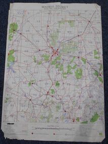
Map - Bush Fire Control Map Bendigo District
A Bush Fire Control map is a valuable tool used by emergency services and communities to respond to respond to bushfires.Cream coloured parchment map showing roads, railway lines, telephone lines, rivers, creeks and water courses. Also marked are houses, Post Offices, Police stations, bush fire brigades, water channels, swamps, marshes, dense, medium and scattered timber, aqueducts and reservoirs. Villages, districts and Towns are clearly marked. Printed in red, green, black and blue. Very clear and easy to read. Undated.bush fires, bendigo area map -
Lakes Entrance Historical Society
Map - Kalimna
Map shows reserve, private streets and Government roads in the township of Kalimna. Shows Princes Highwayroads and streets, township, highways -
Whitehorse Historical Society Inc.
Map, Parkmore Nunawading, c1958
Subdivision plan of Parkmore Estate, Forest Hill using lot numbers.Subdivision plan of Parkmore Estate, Forest Hill using lot numbers. Advertised as a 'complete' community development by Southern Construction Company.Subdivision plan of Parkmore Estate, Forest Hill using lot numbers. parkmore estate, forest hill, parkmore road, forest hill, ranfurlie road, forest hill, quentin street, forest hill, oberon street, forest hill, cherryl street, forest hill, deauville street, forest hill, everglade avenue, forest hill, inglewood avenue, forest hill, cedar court, forest hill, martin court, forest hill, wandin court, forest hill, ranfurlie court, forest hill, hampshire road, forest hill, vanbrook street, forest hill, husband road, forest hill, ashmore road, forest hill, brentford square shopping centre, forest hill, sherman street, forest hill, sylvan court, forest hill, briarfield court, forest hill, yardley court, forest hill, wingrove street, forest hill, jolimont road, forest hill, wembley court, forest hill, longbrae avenue, forest hill, longbrae court, forest hill, teal court, forest hill, marleigh street, vermont, unley court, vermont, irving court, vermont, irving court, vermont, lexington street, vermont, ferncroft street, vermont, southern construction company -
Bendigo Historical Society Inc.
Map - YALLOOK : COUNTY OF BENDIGO, 30-1-28
Map. Yallook, County of Bendigo, L4942, Talambe, Tandarra, Neilborough, Yarraberb, Salisbury, Pompapiel. Drawn and reproduced at the Department of Lands and Survey, Melbourne, Victoria. 30-1-28. H.J. Green, Govt. Printer, Melbourne. (number 18 in map cupboard 1)H.J. Green, Govt. Printer.map, bendigo, yallook -
 Greensborough Historical Society
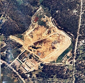
Map - Aerial Photograph, Yarrambat, 04/11/1986
Colour aerial photograph of Diamond Valley Shire Depot, Yarrambat, now Nillumbik Shire Council Works Depot & Recycling CentreColour aerial photograph. Scale approx. 1:1000shire of diamond valley, yarrambat, nillumbik council -
Whitehorse Historical Society Inc.
Map, Melbourne and Metropolitan Board of Works, 1925
1925 plan of the Yan Yean, Maroondah and O'Shannassy water supply systems.1925 plan of the Yan Yean, Maroondah and O'Shannassy water supply systems.1925 plan of the Yan Yean, Maroondah and O'Shannassy water supply systems.water supply, melbourne and metropolitan board of works -
 Bendigo Historical Society Inc.
Map - HUSTLER'S ROYAL RESERVE NO 2 (PARK SHAFT.) - TRANSVERSE SECTION OF THE HUSTLER'S ROYAL RESERVE NO 2
Transverse section of the Hustler's Royal Reserve, No 2 (Park Shaft.) on the Hustler's Line of Reef. Bulletin No 33, Plate No IX. Section shows poppet legs and sill of shaft at 755.70 ft above sea level, depth of levels, type of stone encountered including lava and geological features. Geological Survey of Victoria emblem and beneath it H. Herman, Director, W. Dickson, Secretary of Mines and The Hon. J. Drysdale Brown MLC Minister of Mines and signed by H S Whitelaw, Underground Survey Office, Bendigo September 1913.mining, parish map, hustler's royal reserve no 2 (park shaft.), h s whitelaw, underground survey office bendigo, geological survey of victoria, h herman, w dickson, the hon j drysdale brown mlc, hustler's line of reef -
Whitehorse Historical Society Inc.
Map, Map of Nunawading, 1950?
Map of the entire City of Nunawading: complimentary map issued by Frank Fisher & Co real estate agents, Blackburn.Map of the entire City of Nunawading: complimentary map issued by Frank Fisher & Co real estate agents, Blackburn.Map of the entire City of Nunawading: complimentary map issued by Frank Fisher & Co real estate agents, Blackburn.nunawading, map -
Canterbury History Group
Map - Victorian Railways East Camberwell to Laburnum. Diagram No.3' 58, 1/05/1958 12:00:00 AM
Diagram showing proposed signal and interlocking arrangements for the East Camberwell to Laburnam line 1958canterbury, canterbury station, victorian railways, railway lines -
 Whitehorse Historical Society Inc.
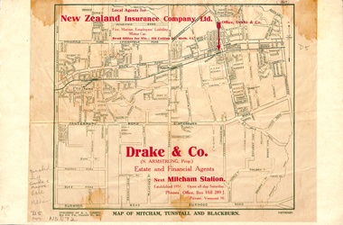
Map, Map of Mitcham, Tunstall and Blackburn, 1920 ?
Map of Mitcham, Tunstall and Blackburn.Map of Mitcham., Tunstall and Blackburn. Overprinted 'Drake & Co.' 1 copy 1927?, 1 copy 193-?Map of Mitcham, Tunstall and Blackburn.mitcham, tunstall, nunawading, blackburn, maps, drake & co., forest hill, vermont -
University of Melbourne, Burnley Campus Archives
Map - Photocopy, University of Melbourne, c. 1999
Photocopy of enlargement of part of Map 2B, University of Melbourne, Parkville Campus, from Melway Street Directory. On part of page showing Brighton, Hampton, Sandringham, etc.university of melbourne, parkville campus, brighton, hampton, sandringham, melbourne -
 Bendigo Historical Society Inc.
Map - MAP: VICTORIA MINING DISTRICTS, MINING DIVISIONS AND THE GOLD FIELDS, 1866
Map: printed map stuck on backing paper (waxed?) to support material. Shows mining districts, divisions and goldfields of Victoria. Printed in blue ink on bottom ' this map compiled in 1866. Printed in 1869.' Printed on bottom ' engraved by William Slight under the direction of R. Brough Smyth FGS Lon., the Hon John Macgregor MLA Minister of Mines, published 24th. October 1866. Revised and corrected by Arthur Everitt, January 25th. 1869. On back of map ' this map was compiled by the Mines Department of Victoria 24th. October 1866, corrected by Arthur Everett 15th. January 1869. Presented to the Bendigo Historical Society by E. Hayward 1st. December 1950.victoria, bendigo, goldfields, gold reefs, mining divisions, map -
Stawell Historical Society Inc
Map, Agricultural Area of Lake Wilson, 1865
Agricultural Area of Lake Wilsonstawell -
 Bendigo Historical Society Inc.
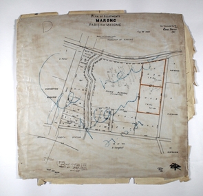
Map - MARONG ALLOTMENTS, 25/08/1906
Map: Plan of Allotments at Marong, Parish of Marong, County of Bendigo. Hand draughted mapmap, bendigo, parish plan, marong, parish of marong -
Bendigo Historical Society Inc.
Map - TARNAGULLA SHEET 2, No date visible
Map: Tarnagulla Sheet 2. Parish plan (number 307 in map cupboard 1)map, parish plan, tarnagulla -
Bendigo Historical Society Inc.
Map - CAMPBELL COLLECTION: BENDIGO & DISTRICT MAPS
Map. Bendigo Whipstick, Scale 40 chains to 1 inch, Forests Commission Victoria, map N0.3, legend for roads and land and forest. (number 371 in map cupboard 1)map, bendigo, country lands -
Bendigo Historical Society Inc.
Map - LEICHARDT, Circa 1870's
Map: Leichardt, Hand draughted parish plan ( number 300 in map cupboard 1 )map, bendigo, parish plan, leichardt -
Canterbury History Group
Map - Canterbury subdivisions, 1996
Photocopy of map from Camberwell Library showing Canterbury subdivisions.canterbury, maps, land subdivisions -
 Bendigo Historical Society Inc.
Map - HUSTLER'S REEF MINE - TRANSVERSE SECTION OF THE HUSTLER'S REEF MINE
Transverse Section of the Hustler's Reef Mine on the Hustler's Line of Reefs. Bulletin No 33, Plate No XVIII. Shows cross-cuts and their depth, different types of stone and geological features encountered. Drawing of poppet legs at the surface and Sill of Shaft 756.39 ft above Sea Level. Reference Table shows key to the different stone and geographical features encountered. Geographical Survey of Victoria. Signed by H A Whitelaw, Underground Survey Office, Bendigo, September 1913. Thompson's Reef is also mentioned on the map. mining, hustler's reef mine, transverse section of the hustler's reef mine, geological survey of victoria, h a whitelaw, underground survey office bendigo, thompson's reef. -
 Glenelg Shire Council Cultural Collection
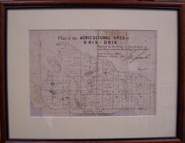
Map - Map of Drik-Drik, 1865
Displayed at History House.Print of map pasted onto board, mounted and framed under glass. Buff-coloured mount. Mahogany stained moulded wood frame, black inner frame.Front: Plan of the Agricultural Area of Drik-Drik L.2556/Prepared by the Board of Lands and Works in accordance with the "Amending Land Act 1865". Lands and Survey Office, Melbourne 11th May 1865. (printed, upper centre). Back: Duncan Hedditchmap, drik drik, plan, geography, cartography -
Stawell Historical Society Inc
Map, Topographic Map Callawadda South
Topographic Map 1:25000 Coloured 1990Callawadda South 7424-2-Smapping -
![Parish of Nunawading, County of Bourke showing land acquired under Closer Settlement Acts [C 1887]](/media/collectors/56f368632162f118acbff12e/items/60d923316e5f99545134f182/item-media/6147b12a4806c7ae686c24e4/item-fit-380x285.jpg) Whitehorse Historical Society Inc.
Whitehorse Historical Society Inc.Map, Parish of Nunawading, ca 1887
Parish of Nunawading, County of Bourke showing land acquired under Closer Settlement Acts [C 1887]Parish of Nunawading, County of Bourke showing land acquired under Closer Settlement Acts [C 1887] 1947 reprint.Parish of Nunawading, County of Bourke showing land acquired under Closer Settlement Acts [C 1887] parish of nunawading, box hill, maps, land settlement -
 Bendigo Historical Society Inc.
Map - Laminated map of Lake Eppalock at full capacity
John Perry Collection. Laminated copy of map of Lake Eppalock at full capacity. Had highlighter markings of old roads which appear to be still in use. The dam was built by the State Rivers and Water Supply Commission of Victoria. The dam wall height is 45 metres (148 ft) and the main embankment is 1,041 metres (3,415 ft) long. At 100% capacity the dam wall was designed to hold back 304,651 megalitres (6.7014×10¹⁰ imp gal; 8.0480×10¹⁰ US gal) of water. The surface area of Lake Eppalock is 3,011 hectares (7,440 acres) and the catchment area is 2,124 square kilometres (820 sq mi). The controlled spillway is capable of discharging 8,040 cubic metres per second (284,000 cu ft/s). Lake Eppalock supplies both stock and domestic water to the Campaspe irrigation district. It also serves as a water supply to Bendigo and Heathcote and, in more recent times, Ballarat. The lake is a major attraction for those engaging in watersports, with a number of tourist parks and accommodation facilities available. Permissible activities on the lake include high-speed boating, water skiing, sailing, canoeing, fishing and swimming. The lake's water levels were low for approximately eight years between 2002 and 2010 during a prolonged drought, which restricted the amount of recreational activity until rainfall in the latter half of 2010 returned the lake to 100 percent capacity. Built between 1961 and 1964, Lake Eppalock remains the only water storage on the Campaspe River system.map, water, dam, reservoir, eppalock -
Lakes Entrance Historical Society
Map - The Gippsland Lakes Boating Restrictions
Four individual maps, Lakes Victoria, Lake King, Paynesville, Raymond Island, Boole Poole, Peninsula Metung to Lakes Entrance showing boat speed limits. 1 pagewaterways, boating, regulations -
 Bendigo Military Museum
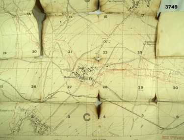
Map - TRENCH MAP, FRANCE WW1, 1917
Areas covered on this map are, “Bullecourt, Reincourt, Hendecourt”. Item relates to William Alexander No 502 AIF. Refer Cat No 3746.3 for his service details.Trench map, France, scale 1:10,000, German trenches in red, trenches corrected to 6.4.1917, Edition 2.map, france, trench