Showing 2222 items
matching documentation
-
 Glenelg Shire Council Cultural Collection
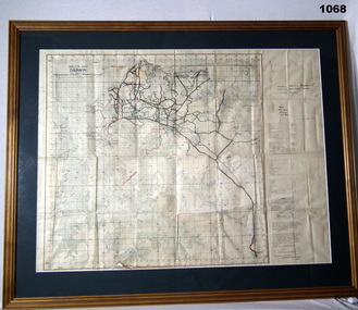
Map - Map- Tarragal, n.d
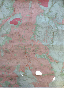
Map - Tarragal - No further information supplied -
Bendigo Historical Society Inc.
Map - GOORNONG : COUNTY OF BENDIGO, September 1943
Map. Goornong, County of Bendigo, Egerton, Bagshot, Ellesmere, Muskerry, Campaspe, Nolan, Campaspe River, Town of Goornong. By authority : H.E. Daw, Government Printer, Melbourne. Drawn and reproduced at the Department of Lands and Survey, Melbourne, Victoria. September 1943, Price 2/-. (number 44 in map cupboard 1)H.E. Daw, Government Printer, Melbourne.map, bendigo, goornong -
Bendigo Historical Society Inc.
Map - CITY OF SANDHURST SHEET NO. 5, 18/04/1882
Map: City of sandhurst sheet No. 5. Parish plan ( number 223 in Map Cupboard 1)map, bendigo, parish plan, sandhusrt -
Federation University Historical Collection
Map, Map of Vitilevu showing vehicular roads, native tracks, villages, provinces, 1935
Printed map on paper backed onto linen with small inset maps of Nandi and Singatoka map, vitilevu, singatoka, nandi -
 Federation University Historical Collection
Map, Creswick, Clunes, Smeaton, Newstead, Yandoit and District, 1904, 06/1904
A coloured geological map with green and pink predominating. The shows Ascot, Creswick, Clunes, Franklinford, Miners Rest, Sandon, Smeaton, Tourello, Yandoitascot, creswick, clunes, franklinford, miners rest, sandon, smeaton, tourello, yandoit, mt moorookyle, powlett's hill, woodhouse's hill, smeaton hill, mcdonald's hill, green hill, spring hill, horse shoe hill, mt cameron, strangways, avoca forest, stanley hunter, j.w. gregory, d. mcleod, donald mcleod, daruel -
Bendigo Historical Society Inc.
Map - HUNTLY : COUNTY OF BENDIGO, August 1954
Map. Huntly, County of Bendigo. Whirrakee, Bagshot, Wellsford, Nerring, Neilborough, Township of Huntly. Drawn and reproduced at the Department of Lands and Survey, Melbourne, Victoria. August 1954. Price 2/-. By authority W.M. Houston, Government Printer. (number 42 in map cupboard 1)W.M. Houston, Govt. Printer.map, bendigo, huntly -
Port Melbourne Historical & Preservation Society
Map - Chart, Port Phillip, 1930
Photocopy in two large sections, of soundings chart for Port Phillip Bay, surveyed by Commander Henry L Cox RN, 1864, with corrections and additions to 1921. Lower section.(Original had stamp of John Donne & Son Stationers)transport - shipping, port phillip bay -
Moorabbin Air Museum
Map (Item) - Maps of Northern Australia and New Guinea, AUS RNC 5 and 6 radio navigation maps
-
Bendigo Historical Society Inc.
Map - ELMORE : COUNTY OF BENDIGO, 4-7-18
Map. Elmore, County of Bendigo, Diggorrra, Burnewang, Runnymede, Nolan, Egerton. Township of Elmore. Campaspe River. Northern Railway Line. Photo-Lithographed at the Department of Lands and Survey, Melbourne by W.J. Butson, 4-7-18.Price 1/-. By authority A.J. Mullett, Govt. Printer. (number 36 in map cupboard 1)A.J. Mullett, Govt. Printer.map, bendigo, elmore -
 Bendigo Historical Society Inc.
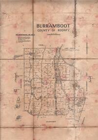
Map - JACK FLYNN COLLECTION: BURRUMBOOT, August 1951
Map: Parish of Burrumboot, County of Rodney. Parish plan.By Authority J.J. Gourley, Government Printer Melbourne. Drawn and Reproduced at the Dept of Lands and Survey, Melbourne, Victoria. August 1951map, rodney, parish plan, burrumboot, rodney -
 Bendigo Military Museum
Map - BATTLE MAP - SYDNEY EMDEN, Possibly 1928
This is a medium size poster. It is drawn in black ink. It shows an image of HMAS SYDNEY, SS BURESK (Collier) and SMS EMDEN. It shows the tracks the two ships took through the battle. It shows dotting lines throughout the drawing - possibly indicating when shots were exchanged. It shows a list in the centre, showing basic specs of the two warships and their battle casualties. It also shows relative positions of Keeling Island and Direction Island.ww1, sms emden, hmas sydney -
Bendigo Historical Society Inc.
Map - CAMPBELL COLLECTION: BENDIGO AND DISTRICT MAPS
Map. Kimbolton, Parishes of Kimbolton and Lyell, scale 20 chains to 1 inch. Area by Planimeter 6258 acres. Knowsley. 10 1/2 miles to Strathfieldsaye. Campaspe River at bottom right of map. (number 365 in map cupboard 1)map, bendigo, allotments -
 Bendigo Historical Society Inc.
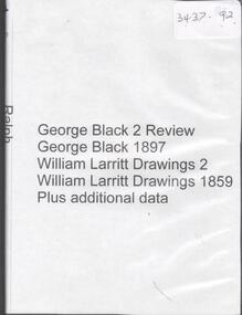
Map - GEORGE BLACK 2 REVIEW, 1859-1897
DVD. George Black 2 Review. George Black 1897. William Larritt Drawings 2, William Larritt Drawings 1859. Plus additional data. -
 Bacchus Marsh & District Historical Society
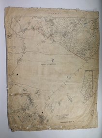
Map, Plan of part of the road district of Bacchus Marsh circa 1856-1862
Local government in much of Victoria including the Bacchus Marsh area began with the formation of 'local committees'. These local committees could make representations to a Central Road Board regarding plans for road construction. Road construction and maintenance were seen as the essential tasks of these early local government authorities. By 1856 the local committee in Bacchus Marsh was constituted as the Bacchus Marsh Road District. This entity continued until 1862 when the name changed to the Bacchus Marsh and Maddingley Road District. This new entity lasted until 1871 when the local government authority in accordance with new statewide legislation became known as the Shire of Bacchus Marsh. The title of this plan being a plan of 'a portion of the road district of Bacchus Marsh' suggests that the plan was produced sometime between 1856 and 1862. The main purpose of this map was to shown the irrigable land in the district and the sources from which water for irrigation could be drawn. Bacchus Marsh was an early irrigation district in Victoria. Irrigation trusts were formed in the 1880s and 1890s to manage irrigation districts. But this was the culmination of many years of earlier attempts to construct irrigation systems in the Bacchus Marsh area and create a system to manage irrigation more broadly. This map dating from around 1856-1862 is an important cartographic document which provides evidence of how the early planning for irrigation was developing in the Bacchus Marsh region.A single page paper map showing a plan of part of the road district of Bacchus Marsh. The map is pasted into a bound volume containing 76 maps or plans in total. High resolution digital image stored on BMDHS computer network. bacchus marsh victoria maps, bacchus marsh road district, local government, road districts, irrigation -
 Warrnambool and District Historical Society Inc.
Map, Colour Photograph
-
 Bacchus Marsh & District Historical Society
Map, Trentham Parish Map 1905 Copy 1
A single page paper map showing the map for the Parish of Trentham in the Counties of Dalhousie and Bourke. A cadastral map showing parish boundaries and land ownership. The map is pasted into a bound volume containing 76 maps or plans in total. High resolution digital image stored on BMDHS computer network. Photo-lithographed at the Department of Lands and Survey, Melbourne by T.F. McGauran 22.3.05 trentham parish maps, trentham parish plan, bacchus marsh region parish plans -
 Bendigo Historical Society Inc.
Map - SANDHURST SHEET 4, 11/03/1925
Map: Sandhurst sheet 4. Parish planmap, bendigo, parish plan, sandhurst -
 Bendigo Historical Society Inc.
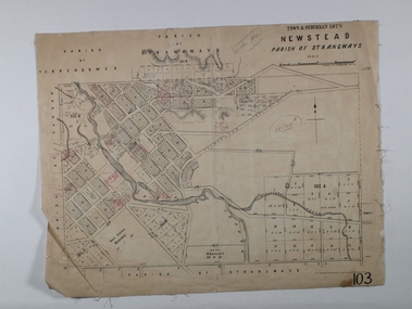
Map - NEWSTEAD ALLOTMENTS, 10/06/1886
Map: Town ans Suburban Lots, Newstead, Parish of Strangwaysmap, allotments, newstead , allotments, parish of strangways -
 Bendigo Historical Society Inc.
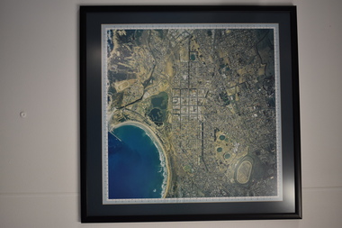
Map - BENDIGO MAP AERIAL VIEW, 1934
Map of Bendigo. Aerial View of Bendigo taken in 1934. Published by City of Great Bendigo.photograph, aerial, bendigo 1934 -
 Wodonga & District Historical Society Inc
Map - Tulloch & Brown's Map of the Colony of Victoria, Tulloch & Brown, 1856
The map was created by Tulloch and Brown. David Tulloch was one of the earliest engravers and lithographers in the state of Victoria. He arrived in Melbourne from Greenock, Scotland, on 3 January 1849. Following the discovery of gold Tulloch went to the Victorian goldfields in 1851, commissioned to make sketches of the diggers and the diggings for Ham’s Illustrated Australian Magazine. In November 1852 Tulloch set up in business as engraver, draughtsman, copperplate printer and lithographer. Tulloch took a map engraver, James Davie Brown, into partnership in March 1853; the several maps and specimens of commercial engraving they showed at the 1854 Melbourne Exhibition were awarded a bronze medal. That year Tulloch and Brown also received a silver medal at the Victorian Industrial Exhibition. The partnership was dissolved towards the end of 1856.This is a very early map of the Colony of Victoria including Belvoir (now know as Wodonga).A foldable map mounted on linen and with a board cover. It records the Colony of Victoria according to Surveyor's Records revised in 1857. Areas of the map are shaded to highlight different counties.At bottom right hand section of map: Tulloch & Brown's map of the Colony of Victoria : comprising part of New South Wales, the boundaries, counties, also seaport & inland townships, the gold fields with the latest discoveries, roads, tracks, &c. &c. / compiled from drawings in the Survey Office and correctly revised till 1857. Respectfully dedicated by Permission, to the Honorable Captain Andrew Clarke R.E. Surveyor General of Victoria by His Obediant Servants Tulloch & Brown, Engravers & Publishers, Melbourne". At bottom right below border : Published as the Act directs by the Proprietors, Melbourne, 1st Feb. 1856. tulloch and brown maps, rare maps victoria, victorian cartography -
Bendigo Historical Society Inc.
Map - MINTO, /01/1884
Map: Minto, County of Bendigo. Parish plan (number 283 in map cupboard 1)map, bendigo, parish plan, minto -
 Bendigo Historical Society Inc.
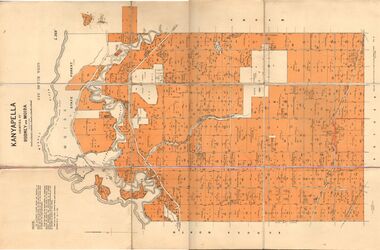
Map - JACK FLYNN COLLECTION: KANYAPELLA, 22/05/1939
Map: Parish of Kanyapella, Counties of Rodney and Moira. Parish plan.By Authority, T. Rider Acting Govt, Printer Melbourne. Drawn and Reproduced at the Dept. of Lands and Survey, Melbourne, Victoria.map, moira, parish plan, kanyapella, counties of rodney and moira -
 Bendigo Military Museum
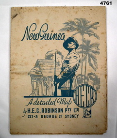
Map - MAP, NEW GUINEA, H.E.C Robinson PTY LTD, Post WW2
Map Robinsons “Territory of New Guinea and Papua” 0ff white colour rectangular shape, shows New Guinea, Papua, New Britain, New Ireland & Bougainville, colours red, orange, yellow, green designating boundaries, when folded one section has in blue a depiction of An Australian Soldier with palm trees & native hut.“Map No 315”maps, new guinea, robinsons -
Bendigo Historical Society Inc.
Map - KANGAROO FLAT SUBDIVISION, 26/11/1900
Map: Plan of Subdivision at Kangaroo flat, Parish of Sandhurst, County of Bendigo ( number 149 in Map Cupboard 1)map, bendigo, parish plan, kangaroo flat, parish of sandhurst, county of bendigo -
Stawell Historical Society Inc
Map, Section of Map, Concongella South, 1945
Section of Map, Concongella Southstawell -
 Ringwood and District Historical Society
Map - Plan of Subdivision, Part of Crown Section 24, Parish of Warrandyte, County of Evelyn - undated, circa 1951
Survey map of residential allotments in Milne Road, east of Berringa Road, Park Orchards, Victoria. -
 Queenscliffe Maritime Museum
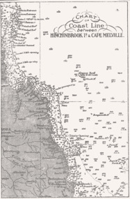
Map - B & W coastal map of Hinchinbrook Island to Cape Melville in Queensland, Coastal map Queensland Hinchinbrook Is to Cape Melville, Before donation in 1987
Australian coastal mapsAustralian coastal mapsMap from unknown book of Queensland coast Hinchinbrook Island to Cape Melville, pre 1987Reverse " NIL "old maps of australian coast -
 Flagstaff Hill Maritime Museum and Village
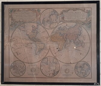
Map - World Map, Mappe Monde [Medieval Map of the World], 1910
This map from the mid-18th century doesn't include the finer details of land and sea masses that we know today. The map was produced by German cartographer and publisher, Johann Baptist Homann (1663-1724) and published in 1746, after his death. Earlier versions were published, such as 1707 and 1716. The date can be calculated from the Roman numerals on the top left text area. This print of a map is significant for its connection with early world explorers. A comparison of maps over the centuries shows the progression of navigational technology, the countries who claimed the land they explored. The naming of even some Australian locations shows who had already made their mark on Australia in the early 18th century. The print shows the fine details included by the cartographer and the beauty included that makes it attractive and interesting even today. The map is also significant for its connection with German cartographer, Johann Baptist Homann, whose Homann publishing company was renewed in Germany for producing high quality maps and atlases. Map behind glass in dark brown wooden frame on beige paper. The Coloured hand drawn line drawings show different hemispheres of the known world in the mid-18th century. Beautifully drawn figures and decorative embellishments enhance the map. The text on the top right has an explanation of the Figures I, II, III, and IV. This print of the 1746 map was produced in England by Leisure Arts Ltd. "PLANIGLOBIL TERRESTRIS" "MDCCXXXXVI" [1746] "MAPPE_MONDE" [Medieval Map of the World] "LEISURE ARTS LTD" "Printed in England"flagstaff hill, warrnambool, flagstaff hill maritime museum, flagstaff hill maritime village, flagstaff hill maritime museum and village, shipwreck coast, world map, french map, 18th century map, leisure arts ltd, cartography, early exploration, cartographer, johann homann (1663-1724), exploration, naviagtion, 1746 planiglobil terrestris -
Whitehorse Historical Society Inc.
Map, Deep Creek Road, Mitcham, c1975
Enlargement of aerial photograph of area bounded by Dalmar Road, Cray Road, Glenvale Road and Maroondah Highway, MitchamEnlargement of aerial photograph of area bounded by Dalmar Road, Cray Road, Glenvale Road and Maroondah Highway, MitchamEnlargement of aerial photograph of area bounded by Dalmar Road, Cray Road, Glenvale Road and Maroondah Highway, Mitchamcray road, donvale, glenvale road, donvale, maroondah highway, mitcham, dalmor road, mitcham, deep creek road, mitcham, aerial photographs -
 Bendigo Military Museum
Map - DAEWIN MAP, FRAMED, 1938
Wooden frame with green border & glass front.Sketch Map of Darwin.documents - maps, frame accessories, darwin