Showing 2222 items
matching documentation
-
 Stawell Historical Society Inc
Map, W.J. Butson, Subdivision of North Woodlands Estate 1922, 12.02.1922
Two (2) Copies. A1 Maps with Cloth Backing Annotated with Title HoldersParishes of Malkaff & Navarre County of Kara Kara Photlithograph by W.J Butson 12.02.2022farming -
Canterbury History Group
Map - Camberwell and Boroondara, Melbourne and Metropolitan Board of Works, c.1905
Copy of Melbourne and Metropolitan Board of Works Plan no. 71 for Camberwell and Boroondaracanterbury, maps, melbourne and metropolitan board of works -
 Ballarat Tramway Museum
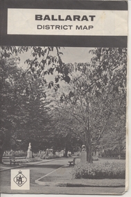
Map, Royal Automobile Club of Victoria, "Ballarat District Map - RACV", c1966
Yields information about the extent of Ballarat in the early to mid 1960's shows the tram lines and other rail lines in the district.Printed street map titled "Ballarat District Map", published by the RACV, showing the central part of Ballarat, Ballarat Outlets, streets, principal attractions, Ballarat and district maps and information, and a list of sporting and entertainment facilities. Has the tram lines shown dotted, does not run out to Sebastopol or the Lydiard St North terminus. Each map in the bottom left hand corner has the numbers "1166", possibly indicating the date.trams, tramways, map, ballarat, racv, railways -
Bendigo Historical Society Inc.
Map - HEATHCOTE, 11/04/1935
Map: Parish of Heathcote, County of Dalhousie. Parish plan (number 320 in map cupboard 1)map, dalhousie, parish plan, heathcote -
 National Vietnam Veterans Museum (NVVM)
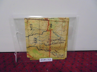
Map
A laminated coloured military map showing topography of areas around Nui Dat with divisional sections hand drawn in black.map, nui dat, mcphail collection -
 Robin Boyd Foundation
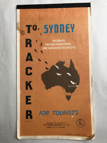
Map, Pic-touring Australia, Tracker to Sydney
Includes the blue mountains and Illawarra districts. beautiful simplified coloured maps. Price 7/6, so pre-decimalisationwalsh st library -
Bendigo Historical Society Inc.
Map - NERRING : COUNTY OF BENDIGO, August 1952
Map. Nerring, County of Bendigo, Yarraberb, Leichardt, Marong, Sandhurst, Huntly, Neilborough, Bendigo and Swan Hill Railway, Bendigo and Kulwin Railway, Loddon Valley Highway. By authority J.J. Gourley, Government Printer, Melbourne. Drawn and reproduced at the Department of Lands and Survey, Melbourne, Victoria. August 1952. Price $1.00. (number 76 in map cupboard 1)J.J. Gourley, Government Printer, Melbourne.map, bendigo, nerring -
Stawell Historical Society Inc
Map, Western Mining Stawell, Germania Summary Plan & Geology Western Mining Corporation, September 1988
Germania Summary Plan & Geopogy Western Mining Corporation Stawell VicGermania Summary Plan & Geology 2003-566 1:1000 mining, gold, map -
Whitehorse Historical Society Inc.
Map, Plan, 1939
Plan of subdivision, part of crown portion 83A and 83, Parish of Nunawading, County of BourkePlan of subdivision, part of crown portion 83A and 83, Parish of Nunawading, County of BourkePlan of subdivision, part of crown portion 83A and 83, Parish of Nunawading, County of Bourkestreet names, parish of nunawading, station street, blackburn, railway road, blackburn, vine street, blackburn, south parade, blackburn, laburnum street, blackburn, main street, blackburn, gardenia street, blackburn, the avenue, blackburn, fuschia street, blackburn, linum street, blackburn -
 The 5th/6th Battalion Royal Victoria Regiment Historical Collection
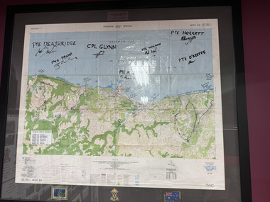
Map - Honiara Map, Honiara West Special used by members of 5/6
Honiara West Special signed by 7 members of 5/6 RVR who were deployed on Operation AnodeThe Map is framed in the glass frame withe the Operation Anode patch, Australian Flag and 5/6 unit symbol displayed below the Map. It has been signed by 7 members of 5/6, each member's PMKey is also displayed on the Map -
 Federation University Historical Collection
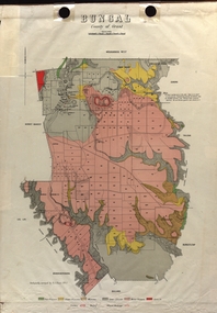
Map - Plan, E.J. Dunn, Bungal County of Grant Parish Plan
E.J. Dunn was the surveyor of this parish plan.Colour geological plan of Bungal in the County of Grant, Victoria. The areas circled in red ar craters.plan, bungal, bungeltap, black horse co. egerton, egerton, mount egerton, sister rose shaft, south learmonth co, kerrit bareet, bungaeeltap, yaloak, eastern moorabool river, corong, bungal station preemptive right, lal lal, western moorabool river, moorabool rover, borhoneychurck, mount egerton battery, bungal creek -
 Ringwood and District Historical Society
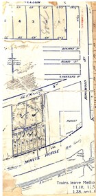
Map, Partially trimmed copy of a retail and residential auction advertisement, Ringwood, Vic. - 1926
One of 3 unrelated land subdivision maps on cardboard backing. Numbered allotments on Nelson Street, Seymour Street and Whitehorse Road, Ringwood.W.J. Bonwick, Licensed Surveyor, Phone WU4830. Location map also includes Bourke Street, Bond Street, Charter Street, Ringwood Street, and Shops and Market sites in Ringwood. -
 Robin Boyd Foundation
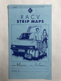
Map, RACV, Strip Maps Melbourne to Portsea
walsh st library -
Glen Eira Historical Society
Map - Gardenvale Road, 11, Caulfield South
A one page typed letter from Equity Trustees to S P Simmonds Estate Agent, dated 12/12/1963, requesting a valuation of the property at 11 Gardenvale Road, Caulfield South. The file also includes a three page typed valuation of the property dated 19/12/1963. It provides details of the property and includes a hand drawn plan (75mm x 100mm) showing measurements of the block. The file also includes one page of undated, unattributed, handwritten working notes for the purpose of the valuation.redapple r r, redapple joseph, redapple rebecca rachel, gardenvale road, caulfield south, land values, brick houses -
Bendigo Historical Society Inc.
Map - PORTION OF SANDHURST, 27/01/1877
Map: Hand draughted parish plan, showing a portion of the City of Sandhurst ( number 225 in Map Cupboard 1)map, bendigo, parish plan, sandhurst -
Whitehorse Historical Society Inc.
Map, Gill's Springfield Road Estate, 1950?
Plan of subdivision for Gill's Springfield Road Estate, former orchard, 16 lots.Plan of subdivision for Gill's Springfield Road Estate, former orchard, 16 lots. Reprinted by Real Estate Agent, Spencer Jackson.Plan of subdivision for Gill's Springfield Road Estate, former orchard, 16 lots. land subdivision, norway avenue, blackburn, springfield road, blackburn, beverley crescent, blackburn, kevin avenue, blackburn, kerr street, blackburn, bordeaux avenue, blackburn, gill's estate, orchards, spencer jackson -
Port Melbourne Historical & Preservation Society
Map - MMBW, Oct 1894
Melbourne and Metropolitan Board of Works 1894 Plan No. 10 Segements shown: 363, 367 and 368 Large scale (40'=1") Swallow Street to Railway Place, Railway pier to mid railyards"Copywrited 14.1.95" written in red ink "311/H"engineering - board of works, business and traders - hotels, transport - railways, transport - tramways -
Bendigo Historical Society Inc.
Map - CAMPBELL COLLECTION: BENDIGO AND DISTRICT MAPS
Map. Lyell, Parishes of Sedgwick, Eppalock and Lyell. Scale 20 chains to 1 inch. Total area 3307 acres. (number 387 in map cupboard 1)map, bendigo, country lands -
 Federation University Historical Collection
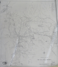
Map, Geological Sketch Map of the Mount Lyell District, 1935, 25-09-1935
Copy of a plan showing mining leases around Mount Lyell, Tasmania.mount lyell, queenstown, mining, king river -
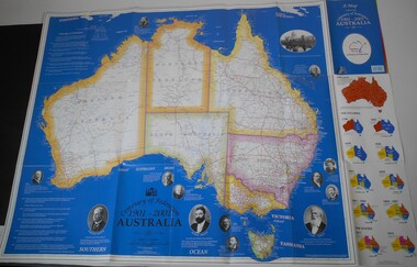 Bendigo Historical Society Inc.
Map - CENTENARY OF FEDERATION MAP OF AUSTRALIA
Map of Australia printed for the Centenary of Federation 1901-2001. Description of the footsteps to federation and starting at left pictures of: John Forrest (first premier of Western Australia) - Edmund Barton (Australia's first Prime Minister) - Charles Kingston (premier of South Australia) - Catherine Helen Spence (first woman to run for political office) - Alfred Deakin ( Australia's first deputy Prime Minister) - John Quick (Force behind the people convention) - Andrew Inglis Clark (Attorney General of Tasmania) - Henry Parkes (Premier of New South Wales) - Robert Garran (helped draft the final version of the Constitution) - George Reid (Premier of New South Wales) - Maybanke Wolstenholme (leading women' s suffrage and Federation campaigner) - Samuel Griffith (former Queensland Premier) - The Exhibition Building, Melbourne - Vaiben Louis Solomon (represented the Northern Territory). On the right the evolution of the colonies and the states from 1788 to 1915.australia, history, centenary of federation -
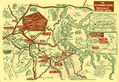 Marysville & District Historical Society
Map (Item) - Tourist map, The Alexandra and Eildon Standard, THE ALEXANDRA & EILDON MARYSVILLE VISITOR GUIDE, 1997
A tourist map for the Alexandra, Eildon and Marysville region that was produced by the Alexandra and Eildon Standard newspaper. This tourist map was produced in 1997.A tourist map for the Alexandra, Eildon and Marysville region that was produced by the Alexandra and Eildon Standard newspaper.c 1997/ PUBLISHED BY/ THE ALEXANDRA/ AND EILDON/ STANDARD./ GRAPHICS/ BY THE T.T.S./ EILDON.alexandra, eildon, marysville, victoria, australia, tourist map, alexandra & eildon standard -
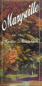 Marysville & District Historical Society
Map (Item) - Information brochure, Project Art & Photo, Marysville in the Mystic Mountains, Unknown
An information brochure on Marysville, the surrounding district and the natural attractions in the region published by Mystic Mountains Tourism.An information brochure on Marysville, the surrounding district and the natural attractions in the region published by Mystic Mountains Tourism.marysville, victoria, australia, information brochure, mystic mountains, mystic mountains tourism, cathedral range, lady talbot drive, cameron cascades, phantom falls, keppel falls, beech forest cascades, the beeches rainforest walk, the big tree, cumberland memorial scenic reserve, cambarville, cumberland falls, cora lynn falls, the big culvert, steavenson falls, lake mountain, marysville visitor information centre -
 Bendigo Historical Society Inc.
Map - REEF MAP OF BENDIGO
Large coloured map of reefs in Bendigo.bendigo, mining -
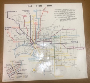 Melbourne Tram Museum
Map, Melbourne & Metropolitan Tramways Board (MMTB), "Tram Route Guide", Aug. 1979
Full colour map or poster printed on clear plastic with an adhesive peel off backing sheets, titled "Tram Route Guide". Map dated 8/79, showing proposed extension to Bundoora, routes with route numbers and names of main destinations. Has notes about the services, weekend and telephone numbers for information. 1979 2 copies held. See Reg Item 1098 for a smaller version of this map.trams, tramways, mmtb, map, routes, posters -
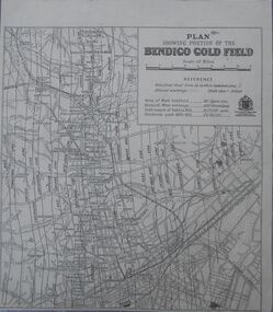 Bendigo Historical Society Inc.
Map - Bendigo Gold Field
Plan showing portion of the Bendigo goldfield. Area of main goldfield: 140 square miles. Deepest mine working: 4593' (Victoria quartz). Gold output of field to 1935: 20,775,000 ounces. Dividends paid 1870-1935: 10,740,000 pounds.map, goldfield, bendigo -
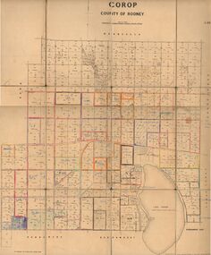 Bendigo Historical Society Inc.
Map - JACK FLYNN COLLECTION: COROP, 8/08/1929
Map: Corop, County of Rodney. Parish plan.By Authority H. J. Green, Govt. Printer, Melb. Dept of Lands and Survey Melbourne by Price 8.8.29map, rodney, parish plan, corop, county of rodney -
Whitehorse Historical Society Inc.
Map, Legislative Council - Electoral Provinces, 1991
State of Victoria. Legislative Council Electoral Provinces. Sheet 3 Metropolitan Map. 1990 - 1991 redivision.State of Victoria. Legislative Council Electoral Provinces. Sheet 3 Metropolitan Map. 1990 - 1991 redivision.State of Victoria. Legislative Council Electoral Provinces. Sheet 3 Metropolitan Map. 1990 - 1991 redivision.electoral boundaries, victoria. parliament. legislative council -
Bendigo Historical Society Inc.
Map - DERBY : COUNTY OF BENDIGO, 1-9-09
Map. Derby, County of Bendigo, Inglewood, Loddon River, Tarnagulla, Woodstock, Leichardt, Bridgewater, Bendigo to Inglewood Railway. Photo-Lithographed at the Department of Lands and Survey, Melbourne, by T.E. McGauran 1-9-09. Price 1/-. (number 55 in map cupboard 1)T.E. McGauranmap, bendigo, derby -
Whitehorse Historical Society Inc.
Map, Shire of Blackburn and Mitcham, c1920
Map of the Shire of Blackburn and Mitcham (Sheet 2) with gas and sewered areas coloured.Map of the Shire of Blackburn and Mitcham (Sheet 2) with gas and sewered areas coloured. Scale 8 chains = 1 inch.Map of the Shire of Blackburn and Mitcham (Sheet 2) with gas and sewered areas coloured.shire of blackburn and mitcham, sewerage and sanitation, gas supply -
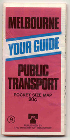 Ballarat Tramway Museum
Map, Ministry of Transport, "Melbourne Public Transport Map" - "No. 9", 1979
Pocket size - folded - public transport map of Melbourne, printed in colour on paper, showing public transport services in greater Melbourne and an index of localities. The Central zone area shown in detail. On the rear, route numbers and line maps of tram routes and train lines or services. Includes private bus routes. Printed for the Ministry of Transport. Issue No. 9. Dated 1979.trams, tramways, melbourne, map, routes