Showing 2222 items
matching documentation
-
 Australian Commando Association - Victoria
Map
-
Port Melbourne Historical & Preservation Society
Map, Port Melbourne City Council, Port Melbourne - Our City, Our Life, Our Choice - No Amalgamation, Jun 1986
Port Melbourne - Our City, Our Life, Our Choice - No Amalgamation Proposal with City of Port Phillip map amalgamation, mayors, local government - city of port melbourne, local government - city of port phillip, liana thompson -
Stawell Historical Society Inc
Map, Riachella, County of Borung, Shire of Stawell, 1920
Riachella, County of Borung, Shire of Stawellstawell -
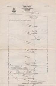 Bendigo Historical Society Inc.
Map - STRUGNELL COLLECTION: HUSTLER'S LINE OF REEFS, BENDIGO, September 1913
Map, Hustler's Line of Reefs, Comet Mine, Longitudinal Section.Plate No.XXV1 (26).Bulletin No 33 Signed H.A.Whitelaw Underground survey Office Bendigo September 1913 Drawing shows the vertical shaft descending to over 1692 feetUnderground Survey Office, Bendigo.map, bendigo, comet mine -
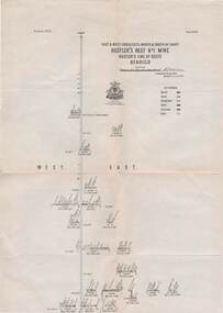 Bendigo Historical Society Inc.
Map - STRUGNELL COLLECTION: HUSTLER'S LINE OF REEF'S. HUSTLER'S REEF NO.1 MINE, September 1913
Map, Hustler's Line of Reefs, Hustler's Reef No. 1, Bendigo, East & West Cross-cuts, North & South of Shaft, Plate No.XX11 (22). Bulletin No 33 Signed H.A.Whitelaw. Drawing shows the vertical shaft descending to over 1229 feet and appears to show samples of connecting horizontal shafts with their respective mineral contentsUnderground Survey Office, Bendigo.map, bendigo, hustler's reef no.1 mine -
Bendigo Historical Society Inc.
Map - SALISBURY WEST : COUNTY OF BENDIGO, 24-6-24
Map. Salisbury, County of Bendigo, County of Gladstone, Powlett, Yarrayne, Bridgewater, Inglewood, Glenalbyn, Kurting, River Loddon, Bulabul Creek. By authority A.J. Mullett, Government Printer, Melbourne. Photo-Lithographed at the Department of Lands and Survey, Melbourne by W.J. Butson, 24-6-24. Price 1/-. (number 116 in map cupboard 1)A.J. Mullett, Government Printer, Melbourne.map, bendigo, salisbury west -
Clunes Museum
Map - DOCUMENTS/MAP, 3 1887. .4 1891
MINING, CLUNES GOLD MINES, MAPS, SECTIONS.1 AERIAL VIEW OF CLUNES AND DISTRICT. COLOUR PHOTOGRAPH LAMINATED. .2 MAP OF MINING AREAS SHOWING EXCISED AREA. No. 9104. MINING DISTRICT OF BALLARAT. PARISH OF CLUNES. COUNTY OF TALBOT. SCALE 4 CHAINS TO AN INCH. .3 MAP OF GOLD MINING LEASE BLOCKS AT CLUNES .4 DRAWINGS OF SECTIONS, CLUNES GOLD MINES. SCALE 400 FEET TO AN NCH. ALL MOUNTED WITH PLASTIC HANGING STRIPS..1 ON BACK. CLUNES 1:25000 .2 ASSORTED HANDWITTEN NOTATIONS. .3 ASSORTED HANDWITTEN NOTATIONS. REPLACE IN DEPT. OF MINING REGISTRARS QUARTER ENDED 30TH JUNE 1887. P. 12.clunes, gold mining, leases, aerial photograph, mine sections -
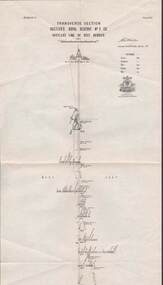 Bendigo Historical Society Inc.
Map - STRUGNELL COLLECTION: HUSTLER'S LINE OF REEF, BENDIGO, September 1913
Map, Hustler's Line of Reef, Hustler's Royal Reserve No. 2 Co, Bendigo,Transverse Section, Plate No.V11 (7). Bulletin No 33 Signed H.A.Whitelaw Underground survey Office Bendigo September 1913 Drawing shows mine shaft to over 1640 feet deep and appears to show samples of connecting horizontal shafts with their respective mineral contentsUnderground Survey Office, Bendigo.map, bendigo, hustler's royal reserve no. 2 mine* -
Stawell Historical Society Inc
Map - Electoral Map, Victorian Government, Map of North - Western ( Country) Electoral Province Legislative Council 1939, 1939
Electoral MapMap Overprinted with Provinces In RedScale 8 Miles to 1 Inchgovernment -
Bendigo Historical Society Inc.
Map - CITY OF BENDIGO RESURVEY SHEET NO. 3, Circa 1900
Map: City of Bendigo Resurvey sheet No. 3. Parish plan ( number 214 in Map Cupboard 1)map, bendigo, parish plan, bendigo, resurvey -
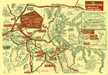 Marysville & District Historical Society
Map (Item) - Tourist map, The Alexandra and Eildon Standard, THE ALEXANDRA & EILDON MARYSVILLE VISITOR GUIDE, 1997
A tourist map for the Alexandra, Eildon and Marysville region that was produced by the Alexandra and Eildon Standard newspaper. This tourist map was produced in 1997.A tourist map for the Alexandra, Eildon and Marysville region that was produced by the Alexandra and Eildon Standard newspaper.c 1997/ PUBLISHED BY/ THE ALEXANDRA/ AND EILDON/ STANDARD./ GRAPHICS/ BY THE T.T.S./ EILDON.alexandra, eildon, marysville, victoria, australia, tourist map, alexandra & eildon standard -
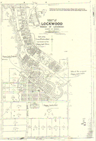 Bendigo Historical Society Inc.
Map - LONG GULLY HISTORY GROUP COLLECTION: LOCKWOOD TOWNSHIP
Copy of a map of Township of Lockwood, County of Bendigo. Printed at the top of the map is: Parish map of Lockwood showing location of Happy Jack's paddock & hut and the sites of the Crown & Anchor Hotel and the original Happy Jack Hotel. Written on the map with arrows pointing to the site is: Happy Jack's Paddock, Site of the original Happy Jack Hotel and Happy Jack's Hut. An outline of Happy Jack's Paddock is drawn in.bendigo, history, long gully history group, the long gully history group - lockwood township, crown & anchor hotel, happy jack hotel, happy jack store, county of bendigo -
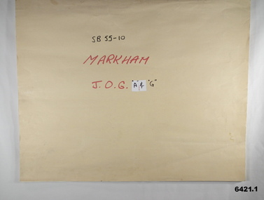 Bendigo Military Museum
Map - SB55-10 Markham Joint Operations Graphics Air and Ground print separations, Royal Australian Survey Corps, Bendigo, Dec 1981
This set of map prints was assembled as a training aid. The collection is a complete set of individual color prints of each colour used on the final printed maps for each map Joint Operations Graphic (JOG) JOG Ground and JOG Air versions. This map series was produced in two versions to help coordinate military Ground Operations and Air Operations. The ground users required that heights and measurements were in Metres, whilst air users required height information in Feet for altimeters. The Air Version also contained more Aeronautical information including safe flying height information called Maximum Elevation Figures (MEF). Later printing of JOG incorporated printing in just four colours Cyan, Magenta, Yellow and Black (CMYK). Item 6421.1 is an example of a JOG Ground and item 6421.2 is an example of its matching JOG Air version.1:250,000 SB55-10 Markham JOG A and G colour separations bound together in a manilla card covered folder bound with a timber edge. royal australian survey corps, rasvy, fortuna, army survey regiment, army svy regt, asr -
Whitehorse Historical Society Inc.
Map, Elmore Houses, 1/08/1993 12:00:00 AM
Elmore Houses - Blackburn Lake Walk [map by] Ken Green. August 1993.Elmore Houses - Blackburn Lake Walk [map by] Ken Green. August 1993.Elmore Houses - Blackburn Lake Walk [map by] Ken Green. August 1993.blackburn, green, ken, elmore houses, elmore, algernon john -
Port Melbourne Historical & Preservation Society
Map - Footscray, Public Lands Office, 19 Oct 1857
Map of Footscray, west of Saltwater Creek; south of Hopkins Street, east of Railway and north southern boundary of Botanical Garden reserve.The Township of Footscray, Parish of Cut-Paw-Pawfootscray -
Bendigo Historical Society Inc.
Map - BENDIGO GOLDFIELD, No date visible
Map: Bendigo Goldfield. Scale 20 chains to 1 inch. Printed by Cambridge Press, Bendigo. (number 318 in map cupboard 1)map, bendigo, mining plan, bendigo goldfield, gold mines, mining -
Whitehorse Historical Society Inc.
Map, Map of Mitcham, Tunstall and Blackburn, c1937
Map of Mitcham, Tunststall and Blackburn showing the location of T.M. McDonnell, real estate agent, Whitehorse Road, MitchamMap of Mitcham, Tunststall and Blackburn showing the location of T.M. McDonnell, real estate agent, Whitehorse Road, MitchamMap of Mitcham, Tunststall and Blackburn showing the location of T.M. McDonnell, real estate agent, Whitehorse Road, Mitchammaps, mcdonnell, t.m. -
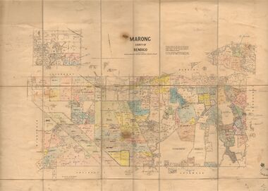 Bendigo Historical Society Inc.
Map - JACK FLYNN COLLECTION: MARONG, June 1933
Map: Parish of Marong, County of Bendigo. Parish plan.By Authority W.M. Houston, Government Printer. Drawn and reporduced at the Dept., of Lands and Survey, Melbourne, Victoria.map, bendigo, parish plan, marong -
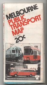 Melbourne Tram Museum
Map, Ministry of Transport, "Melbourne Public Transport Map", c1977
Fold out map (27 sections 9 across x 3 deep), coloured of Melbourne's Tram and Bus routes, route numbers, rail lines, detailed for the central part of Melbourne and insert section for Frankston. On rear description of routes, private bus routes and map of Melbourne metro lines. Has contact details for bookings and lost property etc. Priced 20c Dated 1977, says No. 6 on bottom of rear cover. Note shows route 59 being cut back to the highway.trams, tramways, melbourne, map, tram & bus services, railways, mmtb, minister for transport -
Clunes Museum
Map - CLUNES 1987, CHARLES FENTON, 1987
.1 .2 A MAP OF CLUNES TOWNSHIP - ORIGINAL AND COPY - 1987. ALL STREETS AND BIRCH'S CREEK MARKED WITH ALLOTMENT NUMBERS. .3 SAME MAP SHOWING PATH OF BUSHFIRE IN 1944CLUNES 1987local history, document, maps, clunes township -
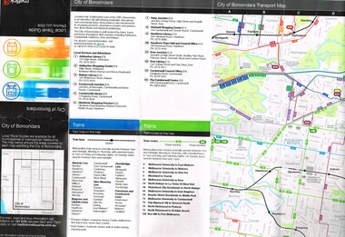 Melbourne Tram Museum
Map, Metlink, "City of Boroondara - Local Travel Guide - July 2008", Jul. 2008
Map, Guide book, Pamphlet, 21 fold, pocket size, titled "City of Boroondara - Local Travel Guide - July 2008" detailing public transport services in the City. Includes map of the tram, train networks, tickets information, tram traction , Connex SMS updates and info on Metlink including contact details. Has a detail map showing services in the city and adjacent overlap area of buses, trams and trains including route numbers. See Reg Item 2283 for Moonee Valley version,trams, tramways, city of boroondara, map, guides, bus services, metlink, connex -
Bendigo Historical Society Inc.
Map - NEWBRIDGE, August 17th 1875
Map: Township of Newbridge, Parish of Tarnagulla, County of Bendigo. Parish plan (number 272 in map cupboard 1)map, bendigo, township, newbridge -
 Bacchus Marsh & District Historical Society
Map, Limestone Reserve Parish of Merrimu 1888
Limestone deposits in the Coimadai area 10 kilometers north of Ballarat were first worked in the 1850s. The area was quarried for limestone for many years by various people and companies. The surveyor's name who produced this plan is inscribed on the map and below this is the name P. L. Alkemade, who presumably paid for the map to be produced. In 1886 Petrus Alkemade in partnership with Matthew Egan established the Alkemade Hydraulic Lime and Cement Company. The Alkemade family were involved in the limestone industry over several generations at Coimadai.Single page map showing part of the Limestone reserve near Coimadai in the Parish of Merrimu. Scale 4 chains to 1 inch. Part of a set of maps which are pasted into a bound volume containing 76 maps or plans in total. High resolution digital image stored on BMDHS computer network. Copy of plan surveyed by Mr. G? [illegible] an authorised surveyor on 17th July 1888. P. L. Alkemadebacchus marsh victoria maps, lime kilns coimadai, limestone, coimadai victoria maps, alkemade family coimadai -
 Bendigo Military Museum
Map - MAP TOBRUK, FRAMED, Post 1941
Coloured map of Tobruk Seige. Lacquered wooden frame, glass front & cardboard backing.Printed top centre: “TOBRUK SEIGE, AUSTRALIAN POSITIONS AS AT 1ST MAY 1941” Donation sticker on bottom LHS. map, tobruk, seige -
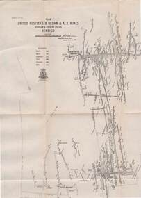 Bendigo Historical Society Inc.
Map - STRUGNELL COLLECTION: UNITED HUSTLER'S & REDAN & K.K.MINES, September 1913
Map, Hustler's Line of Reefs, United Hustler's & Redan & K.K.Mines, Bendigo. Plate No. XXV111 (28),Bulletin 33.Signed H.A.Whitelaw. Drawing seems with their respective mineral contentsUnderground Survey Officemap, bendigo, united hustler's, redan, k.k.mines -
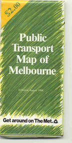 Ballarat Tramway Museum
Map, Ministry of Transport and The Met, "Public Transport Map of Melbourne" - "Effective August 1988", 1988
Map - Pocket size - folded - public transport map of Melbourne, printed in colour on art paper, showing public transport services in greater Melbourne, an index of localities. The City Saver area shown in detail. On the rear, route numbers, line maps of tram routes, train lines, outer metropolitan services, ticketing information, Transport Neighbourhoods, . Shows the St Kilda and Port Melbourne light rail lines. Price $2. Shows "The Met" logo. On front under The Met logo and above the scale bar is "Effective 1/7/1988". Niltrams, tramways, melbourne, map, routes -
Bendigo Historical Society Inc.
Map - CITY OF BENDIGO SHEET 2, No date visible
Map: City of Bendigo Sheet 2, Town plan ( number 143 in Map Cupboard 1)map, city of bendigo sheet 2, city streets -
Clunes Museum
Map - SURVEYERS MAP OF CLUNES, J. FINNIE, 1883
A SURVEYORS MAP OF CLUNES. GEOLOGICALLY AND TOPOGRAPHICALLY SURVEYED BY R.A.F. MURRAY.LITHOGRAPHED BY R. SHEPHERD AND PRINTED BY J. FINNIE MINING DEPARTMENT, MELBOURNE,1883document, surveyers map of clunes, map of clunes -
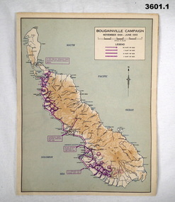 Bendigo Military Museum
Map - MAPS, ISLANDS WW2, Post 1945
Items were owned by William John GARLAND, 5th Army Troop. Illustrated information of the named campaigns of 1944-45..1) Coloured paper map of Bougainville Campaign, New Britain Campaign & Aitape - Wewak Campaign. .2) Coloured paper map of Tarakan Campaign, Balikpapin Campaign & North Borneo Campaign.maps, bouganville, tarakan, islands -
Port Melbourne Historical & Preservation Society
Map, Port Melbourne Sheet 4, 1962
Framed line drawn map of Port Melbourne (sheet 4) 1962, covering the area from Beach Street (including Station and Princes Piers) to Plummer Street and Todd Road area to Dow Streetbuilt environment