Showing 2361 items in the category Documentation with item type Map
-
 Bendigo Historical Society Inc.
Map - HARCOURT : COUNTY OF BENDIGO, December 1951
Map. Harcourt, County of Bendigo, County of Talbot, Town of Harcourt, Walmer, Sutton Grange, Ravenswood, Victorian Water Supply Reservoir, in connection with Barkers Creek Reservoir, Barkers Creek, Calder Highway, Northern Railway, Axe Creek. By authority J.J. Gourley, Government Printer, Melbourne. Drawn and reproduced at the Department of Lands and Survey, Melbourne. December 1951. Price 5/- per sheet. (number 100 in map cupboard 1)J.J. Gourley, Government Printer, Melbourne.map, bendigo, harcourt -
Whitehorse Historical Society Inc.
Map, Shire of Blackburn and Mitcham, 10/10/1939 update
Map of Shire of Blackburn and Mitcham showing Departmental ball hydrants and departmental pillar ball hydrants.Map of Shire of Blackburn and Mitcham showing Departmental ball hydrants and departmental pillar ball hydrants. Scale 8 chains to 1 inch.Map of Shire of Blackburn and Mitcham showing Departmental ball hydrants and departmental pillar ball hydrants.shire of blackburn and mitcham, fire hydrants, blackburn, blackburn north, blackburn south, burwood east, forest hill, mitcham, nunawading, vermont, vermont south -
 Ballarat Tramway Museum
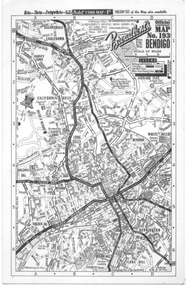
Map, Broadbent's, "Broadbent's Map 193 Bendigo", 1950s
Map of Bendigo showing streets, with the tram routes in dotted lines. Has a legend, scale and continuation maps. Gives an address of 475 Collins St Melbourne and a Melbourne telephone number - MR 2021.Yields information about Bendigo and its tram lines. Broadbents was a prolific publisher of maps. Map - single sided card, pocket map priced at 1/- - undated.bendigo, tramways, tram lines, maps, broadbents -
![Parish of Nunawading, County of Bourke showing land acquired under Closer Settlement Acts [C 1887]](/media/collectors/56f368632162f118acbff12e/items/60d923316e5f99545134f182/item-media/6147b12a4806c7ae686c24e4/item-fit-380x285.jpg) Whitehorse Historical Society Inc.
Whitehorse Historical Society Inc.Map, Parish of Nunawading, ca 1887
Parish of Nunawading, County of Bourke showing land acquired under Closer Settlement Acts [C 1887]Parish of Nunawading, County of Bourke showing land acquired under Closer Settlement Acts [C 1887] 1947 reprint.Parish of Nunawading, County of Bourke showing land acquired under Closer Settlement Acts [C 1887] parish of nunawading, box hill, maps, land settlement -
Bendigo Historical Society Inc.
Map - CAMPBELL COLLECTION: BENDIGO & DISTRICT MAPS
Map. Bendigo Whipstick, Scale 40 chains to 1 inch, Forests Commission Victoria, map N0.3, legend for roads and land and forest. (number 371 in map cupboard 1)map, bendigo, country lands -
Bendigo Historical Society Inc.
Map - HAYANMI, 16/05/1879
Map: Hayanmi, County of Bendigo. Parish plan (number 294 in map cupboard 1)map, bendigo, parish plan, hayanmi -
Bendigo Historical Society Inc.
Map - REDCASTLE, 15/10/1878
Map: Redcastle, County of Rodney. Parish plan. (number 293 in map cupboard 1)map, rodney, parish plan, redcastle -
 Robin Boyd Foundation
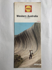
Map, Shell Touring Service, Western Australia
walsh st library -
 Lilydale RSL Sub Branch
map - WWII Australian map, C. G. Hartley & Co 1943, 1943
WWII Australian Issue Map Case/ Plotting Board - with map -
Whitehorse Historical Society Inc.
Map, City of Nunawading, n.d
Map of the City of Nunawading with a list and locations of 48 schools.Map of the City of Nunawading with a list and locations of 48 schools. Scale: 1 mile = 3.75 inches.Map of the City of Nunawading with a list and locations of 48 schools. city of nunawading, schools -
Glen Eira Historical Society
Map - Brady’s Stables, Elsternwick
Hand drawn map and plan (250mm x 200mm) of Brady’s Stables, Elsternwick, undated and unattributed. The file also includes a brief handwritten research note by Peta Darke dated 09/08/2011.brady’s stables, elsternwick, glenhuntly road, glen huntly road, brighton road, elsternwick railway station, nepean highway, stables -
 Bendigo Historical Society Inc.
Map - BENDIGO, No date visible
Map: Parish plan showing the Northern section of the Municipalitymap, bendigo, parish plan, bendigo -
Bendigo Historical Society Inc.
Map - BENDIGO GOLDFIELD, No date visible
Map: Bendigo Goldfield. Scale 20 chains to 1 inch. Printed by Cambridge Press, Bendigo. (number 318 in map cupboard 1)map, bendigo, mining plan, bendigo goldfield, gold mines, mining -
Stawell Historical Society Inc
Map, Local Map of Stawell and District
Local Map of Stawell and Districtstawell -
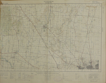
Bendigo Historical Society Inc.
Map - DERBY : COUNTY OF BENDIGO, 1-9-09
Map. Derby, County of Bendigo, Inglewood, Loddon River, Tarnagulla, Woodstock, Leichardt, Bridgewater, Bendigo to Inglewood Railway. Photo-Lithographed at the Department of Lands and Survey, Melbourne, by T.E. McGauran 1-9-09. Price 1/-. (number 55 in map cupboard 1)T.E. McGauranmap, bendigo, derby -
Whitehorse Historical Society Inc.
Map, Springvale Road, 1968
Aerial photograph of cnr Springvale Road and Burwood Highway, south past Highbury Road.Aerial photograph of cnr Springvale Road and Burwood Highway, south past Highbury Road.Aerial photograph of cnr Springvale Road and Burwood Highway, south past Highbury Road.aerial photographs, highbury road, burwood east, burwood highway, burwood east, springvale road, burwood east -
Bendigo Historical Society Inc.
Map - RAVENSWOOD : COUNTY OF BENDIGO, 28-7-14
Map. Ravenswood, County of Bendigo, County of Talbot, Lockwood, Sutton Grange, Harcourt, Walmer, Bradford, Shelbourne, Mandurang, Photo-Lithographed at the Department of Lands and Survey by T.F. McGauran 28-7-14. (number 86 in map cupboard 1)T.F. McGauranmap, bendigo, ravenswood -
 Whitehorse Historical Society Inc.
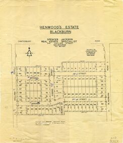
Map, Henwoods Estate, Blackburn
Plan of subdivision in Blackburn SouthPlan of subdivision in Blackburn South between Holland Road and Blackburn Road. Estate advertised by Spencer Jackson, 341 Collins Street.Plan of subdivision in Blackburn South land subdivision, henwoods estate, blackburn south, holland road, brazeel street, marama street, blackburn road, gissing street, hearty street -
 Bendigo Historical Society Inc.
Map - CAMPBELL COLLECTION: BENDIGO AND DISTRICT MAPS
Map. Parish of Sandhurst, Parish of Huntly, Parish of Nerring, Parish of Marong, Parish of Lockwood, Parish of Wellsford, Parish of Strathfieldsaye, Parish of Mandurang. Scale approx 1:18,000.map, bendigo, parishes -
 Bendigo Historical Society Inc.
Map - Map of overlay of lake Eppalock at full capacity. Map 'C'
John Perry collection. Map 'C'. Laminated map of overlay of Lake Eppalock at full capacity. Circa 1951. The dam was built by the State Rivers and Water Supply Commission of Victoria. The dam wall height is 45 metres (148 ft) and the main embankment is 1,041 metres (3,415 ft) long. At 100% capacity the dam wall was designed to hold back 304,651 megalitres (6.7014×10¹⁰ imp gal; 8.0480×10¹⁰ US gal) of water. The surface area of Lake Eppalock is 3,011 hectares (7,440 acres) and the catchment area is 2,124 square kilometres (820 sq mi). The controlled spillway is capable of discharging 8,040 cubic metres per second (284,000 cu ft/s). Lake Eppalock supplies both stock and domestic water to the Campaspe irrigation district. It also serves as a water supply to Bendigo and Heathcote and, in more recent times, Ballarat. The lake is a major attraction for those engaging in watersports, with a number of tourist parks and accommodation facilities available. Permissible activities on the lake include high-speed boating, water skiing, sailing, canoeing, fishing and swimming. The lake's water levels were low for approximately eight years between 2002 and 2010 during a prolonged drought, which restricted the amount of recreational activity until rainfall in the latter half of 2010 returned the lake to 100 percent capacity. Built between 1961 and 1964, Lake Eppalock remains the only water storage on the Campaspe River system.map, water, eppalock, dam, reservoir -
 Ballarat Tramway Museum
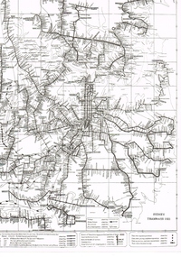
Map, South Pacific Electric Railway, c1970's
702.1 Map of Sydney Trams - diagrammatic in 1921, includes electric and steam, shows streets, railways and where starting (Not original a reproduction) 702.2 - as above, but shows track layout, crossovers etc. - more to scale, also a reproduction. Image added 20-12-2016.trams, tramways, map, sydney -
Stawell Historical Society Inc
Map, Fred W Wright Surveyor, Plan of the Borough of Stawell showing Mining leases & reefs 1870, 1870
Mining details. Including Tramways, Water Races. Crushing Mills. Reefs and Reserves.Copy of Original Showing Stawell Borough with details including mining leases Companies and MillsInsert with details of Sections 23, 34, 35 & 36. Fred W Wright 12 May 1870mining -
 Ringwood and District Historical Society
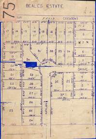
Map, Subdivision Plan of 37 residential allotments on Panorama Avenue, Felix Crescent, Evelyn Road and Avalon Grove, Ringwood, Victoria - (Undated - circa 1960)
Stencilled copy of map on blue cardboard backingBeales Estate -
Bendigo Historical Society Inc.
Map - CAMPBELL COLLECTION: BENDIGO AND DISTRICT MAPS, 12-2-29
Map. Axedale, Parishes of Ellesmere and Axedale. Scale 20 chains to 1 inch. To the west is Wellsford. Total area 4156 acres. Prepared in W.P.B. from A and P plans by W.J. Galbraith 12-2-29. (number 352 in map cupboard 1)W.J.Galbraithmap, bendigo, agricultural lands -
 Federation University Historical Collection
Map, Sunbury, 1938
Printed colour map on papersunbury -
Bendigo Historical Society Inc.
Map - TARNAGULLA SHEET 2, No date Visible
Map: Tarnagulla Sheet 2, Parish planmap, parish plan, tarnagulla -
Whitehorse Historical Society Inc.
Map, Sketch plan of Box Hill Cemetery, c1980
Sketch plan of Box Hill Cemeterybox hill cemetery -
Bendigo Historical Society Inc.
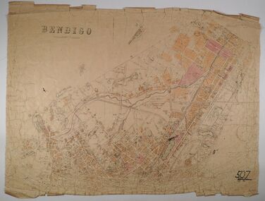
Map - PARISH OF SANDHURST 1961, 1961
BHS CollectionAt Bendigo Parish of Sandhurst. Sheet F.Dept of Lands and Surveybendigo, land sales, parish map -
 National Vietnam Veterans Museum (NVVM)
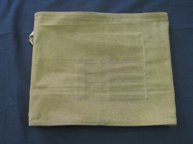
Map, Map Cloth
Cloth map of Western Pacific region noting countries and water currents around. map is double sidedmap -
University of Melbourne, Burnley Campus Archives
Map (item), Proposed Reserve for Horticultural & Experimental Garden in the Survey Paddock. Clement Hodgkinson Deputy Surveyor General, 1862
horticultural & experimental garden, survey paddock, clement hodgkinson