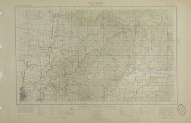
Showing 2247 items in the category Documentation with item type Map
-
 Federation University Historical Collection
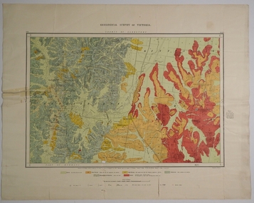
Map - Geological Survey, J. Phillips, Geological Survey of Victoria - Ballarat, 1857, 10/1858
Geological map of the Ballarat District featuring four colours.ballarat, geological, geology, geological plan, main road, camp, golden point, pennyweight hill, clayton hill, ballaarat cemetery, bakery hill, specimen hill, soldiers hill, nightingale lead, native youth black hill flat, white flat, mining, mines, eureka lead, old post office hill -
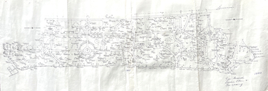 Friends of Ballarat Botanical Gardens History Group
Map - Map of Trees in the Ballarat Botanical Gardens, Tree Research - Location Plan and Naming, 1983
john garner collection, ballarat botanical gardens, gardens, ballarat, trees, map, 1983 -
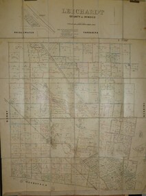 Bendigo Historical Society Inc.
Map - JACK FLYNN COLLECTION: LEICHARDT, 14/03/1`939
Map: Parish of Leichardt, County of Bendigo. Parish plan.Drawn and Reproduced at the Dept, of Lands and Survey, Melbourne, Victoria. 14.3.1939map, bendigo, parish plan, leichardt -
 Bendigo Historical Society Inc.
Map - CAMPBELL COLLECTION: BENDIGO AND DISTRICT MAPS
Map. Ascot Unit, scale 20 chains to an inch, arrow pointing to magnetic north, road to Fosterville to the East, Huntly 3/4 mile to the West, road to Epsom 3/4 mile and road to Bendigo 4 1/2 miles south west on map, also on page is the Northern Railway (Bendigo to Echuca) line. (number 355 in map cupboard 1)map, bendigo, country lands -
Bendigo Historical Society Inc.
Map - BRIDGEWATER, 10/09/1913
Map: Bridgewater, Parishes of Bridgewater and Inglewood, Counties of Bendigo and Gladstone (number 276 in map cupboard 1)map, bendigo, parish plan, bridgewater -
Bendigo Historical Society Inc.
Map - CAMPBELL COLLECTION: BENDIGO AND DISTRICT MAPS
Map. Marong, Parishes of Marong, Lockwood and Mandurang. Scale 20 chains to an inch. Total 5106 acres. Compiled in W.P.B. from Field Survey and Parish Plans. Crusoe Reservoir to the right of map. (number 362 in map cupboard 1)map, bendigo, parish plan -
Bendigo Historical Society Inc.
Map - GOORNONG, 1/10/1906
Map: Town of Goornong, Parish of Goornong, County of Bendigo. Parish plan (number 269 in map cupboard 1)map, bendigo, township, goornong -
University of Melbourne, Burnley Campus Archives
Map, Plan of Early Melbourne Showing Original Crown Allotments, c. 1852
Copy of 'Map of the City of Melbourne, and its Extension, together with Collingwood, Richmond, Hawthorne, the Emerald Hill, and a portion of Prahran Compiled from the Government Plans and Private Survey by William Green.' (2 copies, one enlarged)melbourne, william green, richmond, hawthorne, collingwood -
Bendigo Historical Society Inc.
Map - TALAMBE, 26/11/1880
Map: Parish of Talambe, County of Bendigo. Parish plan (number 315 in map cupboard 1)map, bendigo, parish plan, talambe -
 Bendigo Historical Society Inc.
Map - COUNTY OF GLADSTONE, November 1910
Map: County of Gladstone, Geological survey of Victoria. Geological mapmap, gladstone, geological, county of gladstone, geological map -
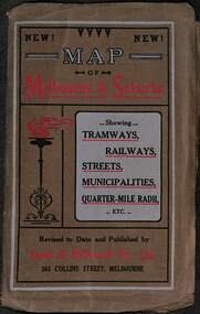 Melbourne Tram Museum
Map, Sands McDougall, Map of Melbourne and Suburbs showing Tramways, Railways, Streets, postal districts, Quarter-Mile Radii etc", c1919
Shows railways, cable and electric tram lines c1919. One of a number of maps produced by Sands McDougall of Collins St. Includes the MTOCo zoo horse tram lines, the PMTT, HTT and MBCTT lines, but not the FNPTT or the FTT lines. See items 2885 and 6573 for other editions. Yields information about Melbourne c1919 and its public transport lines. Produced by Sands and McDougall Pty Ltd of Collins St Melbourne. folded sheet of paper 6 sections wide x 6 sections or folds deep contained within a brown paper cover titled "Map of Melbourne and Suburbs showing Tramways, Railways, Streets, postal districts, Quarter-Mile Radii etc", showing both cable and electric tramways. maps, melbourne, cable trams, tramways, railways, horse trams, nmetl, vr trams, sands mcdougall, mbctt, pmtt, htt, zoo horse tramway -
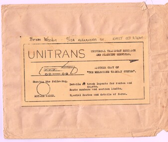 Melbourne Tram Museum
Map, Russell J. Nowell, "The Melbourne Tramway System", mid 1960's
Printed map (dye line process) on a large sheet of paper contained within an envelope. .1 - Brown paper envelope with a printed sheet glued to the envelope - giving title "The Melbourne Tramway System", publisher ("Unitrans - Universal Transport Research and Planning Services" - with a space for the retail price. .2 - Map printed on paper and folded into 16 parts - details the track layouts for routes and depot, route numbers, sections, Latrobe and William St services and details of fares. Has a sketch of tram 980 in the top right hand corner along with details of the tram system. Also includes depot locations, reserved tracks and derails at level crossings, though railway level crossings are not shown. Produced by Russell J. Nowell - gives address and phone number along with the "UniTrans" logo. Advised by other members, he was a Tasmanian. Not dated, but appears to be mid 1960's. Plan scanned 1-3-2016 as a tiff file.Envelope has the name and address of the donor "Brian Weedon 5/124 Alexandra St East St Kilda"trams, tramways, map, mmtb, depots, tram routes, trackwork -
Whitehorse Historical Society Inc.
Map, Blackburn East Primary School
Plans of Blackburn East Primary SchoolPlans of Blackburn East Primary School (1)1957; (2) Master Plan ; (3) Master Plan 1973. (4) Scheme F: Staff and administrative facilities 1974, Scale 1/8:1'Plans of Blackburn East Primary Schoolblackburn east primary school no. 4800, master plan, admin facilities -
Canterbury History Group
Map - Canterbury subdivisions, 1996
Photocopy of map from Camberwell Library showing Canterbury subdivisions.canterbury, maps, land subdivisions -
University of Melbourne, Burnley Campus Archives
Map (item) - Geological map, Geological map of Melbourne & suburbs. Issued by the Department of Mines, Victoria, 1937
-
 Federation University Historical Collection
Map, Yan Yean, 1935, 05/1935
Printed colour map on paperyan yean -
 Bendigo Historical Society Inc.
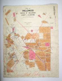
Map - TOWN OF INGLEWOOD, March 1946
Map: Town of Inglewood, Parish of Inglewood, County of Gladstone. Parish planmap, gladstone, township, inglewood -
 Bendigo Historical Society Inc.
Map - NEW CHUM LINE, 1875
Plan: Longtitudinal section of the Southern Section of the New Chum Line of Reef. Compilation consisting of small sections stapled togetherCALEB THOMAS 1875map, mining plan, gold mines, new chum line -
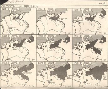 Bendigo Historical Society Inc.
Map - GERMAN HERITAGE SOCIETY COLLECTION: GROWTH OF PRUSSIA
Photocopy of a map titled Growth of Prussia. Nine maps with the dates 1415, 1524, 1618, 1648, 1720, 1744, 1772, 1793 and 1795. Maps have letters (a) to (i) as well.map, german heritage society collection - growth of prussia-map 38 -
Bendigo Historical Society Inc.
Map - WOODSTOCK : COUNTY OF BENDIGO, 4-7-35
Map. Woodstock, County of Bendigo, Derby, Leichardt, Marong, Shelbourne, Laanecoorie, Tarnagulla. Bradford Creek, Maldon and Laanecoorie Railway. Drawn and reproduced at the Department of Lands and Survey, Melbourne, Victoria.4-7-35. Price 2/-. By authority H.J. Green,Govt. Printer. (number 41 in map cupboard 1)H.J. Green, Govt. Printer.map, bendigo, woodstock -
Bendigo Historical Society Inc.
Map - TALAMBE : COUNTY OF BENDIGO, 17-12-15
Map. Talambe, County of Bendigo, Hayanmi, Dingee, Tandarra, Yallook, Pompapiel. Photographed at the Department of Lands and Survey, Melbourne by W.J. Butson,17-12-15, Price 1/-. Albert J. Mullett, Govt. Printer, Melbourne. (number 17 in map cupboard 1)Albert J. Mullett, Government Printer, Melbourne.map, bendigo, talambe -
Bendigo Historical Society Inc.
Map - HUNTLY : COUNTY OF BENDIGO, August 1954
Map. Huntly, County of Bendigo. Whirrakee, Bagshot, Wellsford, Nerring, Neilborough, Township of Huntly. Drawn and reproduced at the Department of Lands and Survey, Melbourne, Victoria. August 1954. Price 2/-. By authority W.M. Houston, Government Printer. (number 42 in map cupboard 1)W.M. Houston, Govt. Printer.map, bendigo, huntly -
Stawell Historical Society Inc
Map, Township of Crowlands, Parish of Crowlands, County of Kara Kara, 1857
Township of Crowlands, Parish of Crowlands, County of Kara Kara stawell -
Bendigo Historical Society Inc.
Map - CAMPBELL COLLECTION: BENDIGO AND DISTRICT MAPS, 9-4-29
Map. Campaspe, Parish of Kimbolton, Scale 20 chains to 1 inch. Total area 4117 acres, Campaspe River, Prepared in W.P.B. by W.J.Galbraith from Parish and Assessment Plans. (number 384 in map cupboard 1)W.J.Galbraithmap, bendigo, agricultural lands -
Whitehorse Historical Society Inc.
Map, Sketch map, 1932
Sketch map of Doncaster, Mitcham and Tunstall. Scale 1 inch = 40 chains. 4th issue. 19 Apr 32Sketch map of Doncaster, Mitcham and Tunstall. Scale 1 inch = 40 chains. 4th issue. 19 Apr 32Sketch map of Doncaster, Mitcham and Tunstall. Scale 1 inch = 40 chains. 4th issue. 19 Apr 32maps, doncaster, mitcham, tunstall, nunawading -
 Whitehorse Historical Society Inc.
Map - Civic Map, Subdivision of Village of Springfield, 1861
Map of the subdivision of the Springfield Estate, Nunawading, 1861. The Springfield Estate was located in the Northwest corner of Whitehorse Road and Springvale Road.Map of the subdivision of the Springfield Estate, Nunawading, 1861. Springfield Estate was located in the Northwest corner of Whitehorse Road and Springvale Road.non-fictionMap of the subdivision of the Springfield Estate, Nunawading, 1861. The Springfield Estate was located in the Northwest corner of Whitehorse Road and Springvale Road.springfield estate, whitehorse road nunawading, springvale road nunawading -
Stawell Historical Society Inc
Map, Gold Mines of Australia, Gold Mines of Australia underground workings. Newington Rd Darlington Rd Area 1950, 1950
Plans Showing Surveys & Drilling Stawell InvestmentGold Mines of Australia Stawell Investment 2003 mining, gold, map -
Bendigo Historical Society Inc.
Map - SALISBURY WEST, 29/01/1878
Map: Salisbury West, County of Gladstone. Parish plan (number 305 in map cupboard 1)map, gladstone, parish plan, salisbury west -
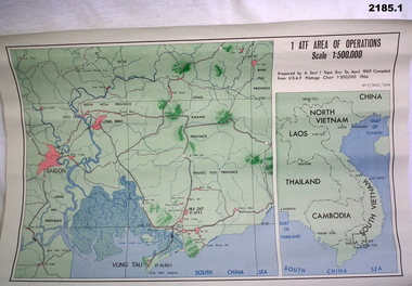 Bendigo Military Museum
Map - MAPS, VIETNAM, April 1969
1.) Paper map, colour with black print, scale 1:500,000 area covers Saigon, Long Bin, Nui Dat, Vung Tau. .2) Laminated paper map showing city of Vung Tau with details of tourist destinations, hotels, churches, black & red print, scale 1:12,500 approx.documents - maps - military & tourist, vietnam -
Port Melbourne Historical & Preservation Society
Map, G S Williams, City Engineer, City of Port Melbourne, Dec 1963
Map of City of Port Melbourne (brick areas marked in colour), 1963.G. S. Williams (City Engineer)town planning, g s williams, troedel and cooper