Showing 85012 items
matching documentation
-
 Federation University Historical Collection
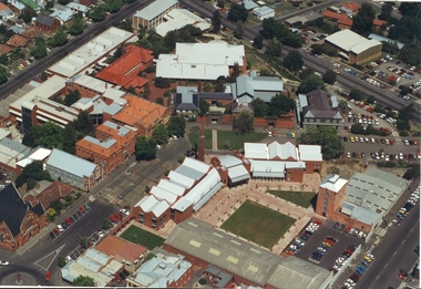
Photograph - Photograph - Colour, Aerial Views of Sites Relating to the University of Ballarat, c1998
The Ballarat Technology Park is associated with Federation University Australia. Five colour aerial photographs of sites associated with Federation University Australia. .1 & .2) Aerial views of the State Data Centre, Ballarat Technology Park .3) Aerial view of Mt Helen Campus, c1990 .4 and .5) Aerial View of Ballarat School of Mines Campus, 1998ballarat technology park, state region data centre, ballarat aerial view, ballarat school of mines aerial, aerial, brewery building, ballarat uniting church, albert street -
 Eltham District Historical Society Inc
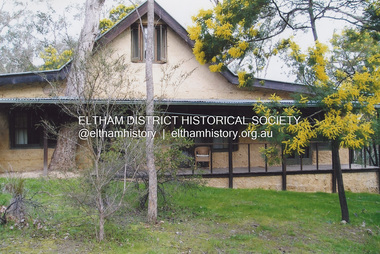
Photograph, Fay Bridge, Birrarung House, 195 Laughing Waters Road, Eltham, 7 September 2013
Laughing Waters Walk, 7 Sep 2013 This Society excursion was a follow up to the Laughing Waters Story told to us by Jane Woollard at our Annual General Meeting in March 2013. It involved a walk commencing from the corner of Laughing Waters and Overbank Roads along Laughing Waters Road to its eastern end and returning partly over the same route - a total distance of about 2.5km. On the way we visited the two artist in residence properties, River Bend and Birrarung, to view the houses on them that are associated with Alistair Knox, Gordon Ford and others in the local mud brick and artistic community. We also able to walk around the derelict ruin which was once home to Gordon and Sue Ford, Boomerang House. An unexpected afternoon tea was offered to us by the artists in residence at Birrarung House and we had a brief opportunity to view inside the house. Birrarung is situated near the end of Laughing Waters Road. It was built in 1974 by Graeme Rose for Gordon Ford who he had asked to build him a small ‘bach’. Builder Peter Jarvis who did his apprenticeship with Alistair Knox for a couple of years recalled there were no drawings. It evolved as more funds became available. Graeme would source second-hand building materials around which he would shape the house. The fireplace was built with chicken wire over which it was rendered with faro cement. A brick floored glass studio, added later, faces a wall of boulders pressed into a manmade cliff, a large pond the link between the rock wall and glass studio. A waterfall, fed by river water, no longer functions. The property became part of the Laughing Waters Artist in Residency Program with the first artist taking up residency in 2001. For a more in-depth description of the property and biographies of the various artists in residence commencing from 2001 through to 2015, see Jane Woollard's book, "Laughing Waters Road; Art, Landscape & Memory in Eltham" published 2016.2013-09-07, activities, artists in residence, eltham district historical society, heritage excursion, laughing waters road, birrarung house, fay bridge collection -
 Lakes Entrance Historical Society
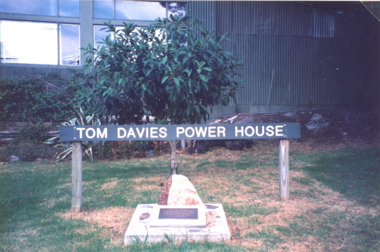
Photograph - Tom Davies plaque, Mallacoota Powerhouse, M Fish, Mallacoota Victoria
Colour photograph of plaque honouring Tom Davies operator of the Power House Mallacoota Victoria. Also a colour photograph showing details of plaque at Mallacoota Power House electricity, plaques -
 Vision Australia
Photograph - Image, John Cook portraits for reports
Portrait images of John Cook, most likely taken for an annual report.Col. transparencies of John Cookassociation for the blind, john cook -
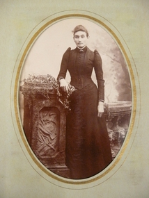
 St Kilda Historical Society
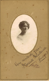
Photograph, T Humphrey & Co, Florence Henderson
mounted sepia photograph, original, fair conditionOn front: Very sincerely yours, June 1913 -
 Melbourne Legacy
Photograph, Widows activities
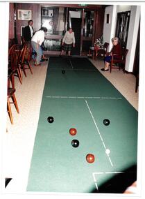
A group of widows playing indoor bowls at Legacy House. It is on the same film as photos of a craft exhibition. They show the social side of being in a widows club. Names unknown.A record of the type of activities Legacy provided as a social outlet for widows. Colour photo of widows playing indoor bowls at Legacy House.Printing on the back "widows, bowls, activities -
 Clunes Museum
Photograph, 1950S
BLACK AND WHITE PHOTOGRAPH OF 5 CHILDREN BESIDE A CAR. JUNIOR COUNTRY WEEK 1950s. IDENTIFIED AS (REAR) MAC FAWCETT, MAUREEN BLISS (FRONT) UNKNOWN, JOHN KELLER, PETER KELLERHANDWRITTEN IN BLUE BIRO ON REVERSE OF PHOTOGRAPH: MAC FAWCETT, MAUREEN BLISS, JOHN KELLER, PETER KELLER - COUNTRY WEEK 1950'Sjunior country week, 1950s, sports -
Glenelg Shire Council Cultural Collection
Photograph - Photographic print of a rephotographed photograph - 32 Percy Street Portland, c. 1970
Photographic print of a rephotographed photograph. Image shows double storey weatherboard building. Verandah at front. Shepherds Arms Hotel, 32 Percy Street, originally called Sign of the Good Woman Inn. -
 Melbourne Legacy
Photograph, Melbourne Legacy, Kew Class 1953, 1953
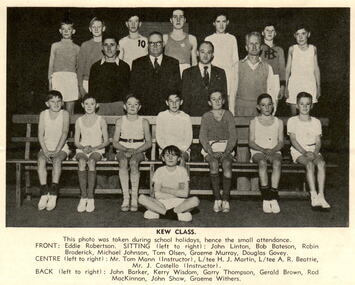
A photo from a newsletter from September 1953. The photo shows the Kew boys class, which met at the Kew Drill Hall on corner of High Street and Highbury Grove, Kew on Friday nights at 7.30. The instructors were Messrs Tom Mann and Jack Costello and has 53 members Front row: Eddie Robertson. Seated: John Linton, Bob Bateson, Robin Broderick, Michael Johnson, Tom Olsen, Graeme Murray, Douglas Govey. Centre: Mr Tom Man (Instructor), Legatee HJ Martin, Legatee AR Beattie, Mr J Costello (Instructor). Back: John Barker, Kerry Wisdom, Garry Thompson, Gerald Brown, Rod MacKinnon, John Shaw, Graeme Withers. Other names mentioned in the article include new boys, Alan Bateson, Douglas Govey, John Linton, Robert Bateson, Evan Houston, Robert Ritchie, Robin Broderick, John Huxtable. It also gives the phone numbers of Legatees AR Beattie, HJ Martin, A Crawford and RS Isherwood in case a reader would like their son to attend a class. The article mentions that the photos of the boys classes were donated to Legacy by Mr John Beckett of Sandringham. Individual photos being catalogued to record detail about each one.The newsletter outlining news of Junior Legatee activities with mentions of boys by name.Black and white photo of the Kew boys class printed in a newsletter in September 1953.junior legatees, boys classes -
 Lakes Entrance Historical Society
Photograph, Lakes Post Newspaper, 1993
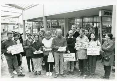
Names unknown, gathering held in protest at cutbacks to fundingBlack and white photograph group of teachers and parents holding plaques at a stop work gathering at shopping arcade in Lakes Entrance Victoriaschools, protest -
 Ballarat Heritage Services
Photograph - Photograph - Colour, Clare Gervasoni, St Laurence O'Toole Catholic Church, Sandon, 2017, 16/07/2017
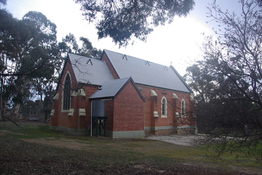
St Laurence O'Toole church and cemetery is located in a rural setting at 801/821 Creswick-Newstead Rd, Sandon. Originally a small wooden school (22’x14’) was erected in Sandon by Father Patrick Smyth (who was involved in the Eureka Stockade movement) in 1859. It was also used for Mass and became known as a chapel. In June 1882 tenders were called for the construction of a brick Church by the Castlemaine architect, T.F. Kibble, and it was built at a cost of 1000 pounds. The church was blessed by Archbishop Goold on 06 May 1883 and dedicated to St Laurence O'Toole. The brick building demonstrates original design qualities of a Victorian Rudimentary Gothic style, including the steeply pitched, parapet gable roof form, together with a central steeply pitched, gabled porch that projects slightly from the main gable end. Other intact qualities include the exposed brick wall construction, lapped galvanised corrugated iron roof cladding, minor gabled porch at the rear, small ventilation dormers nearby the roof ridgeline, series of stone steps that lead to the central porch with its double pointed door opening and vertical boarded doors, simple rose window in the main gable end, pointed windows, brick buttresses with double lower copings, and the light masonry detailing (the banding marking the floor level within, buttress copings, window and door surrounds and quoins, and the drip moulds).(Shire of Mount Alexander: Heritage Study of the former Shire of Newstead, 2000) The visually connected cemetery demonstrates important visual qualities formed by the regular rows of graves and cemetery architecture, and the grassed and treed rural landscape. It is a rare and substantially intact example of a Victorian Catholic Church with a cemetery in its churchyard. Many headstones and cemetery architecture, date from the 19th century and represent some fine examples of masonry craftsmanship. Some refurbisments occurred during the 1940s and in 2002 a major restoration project was undertaken from roof to footings, by a dedicated band of volunteers and trades people. Work was completed mid 2003 and in November 2003 St Laurence’s was re-dedicated with the celebration of Mass and a picnic tea. Brick church at Sandon, Victoriasandon, sandon cemetery, st laurence o'toole catholic church, sandon -
 Eltham District Historical Society Inc
Photograph, Christmas Hills Public Hall, c.2008
Christmas Hills Public Hall, formerly the Mechanics Insitute of the late 1880sColour photo print 10 x 15 cm (2)christmas hills, mechanics insitute, public hall -
 Bendigo Historical Society Inc.
Photograph - GRANT DAVIS COLLECTION: BLACK AND WHITE GROUP PHOTO INCLUDING FRANKLYN DAVIS
Grant Davis Collection black and white group photo with brown border including Franklyn Joseph Davis (centre middle ) .The photo appears to be of members of a play Three men and six women wearing Victorian era costumes on a stage with background scenery .There is a paper? Parasol with the words -The Geisha Tea house and function rooms next age officephotograph, portrait, 'the geisha tea house and function rooms next age office -
City of Kingston
Photograph - Colour, Circa 1993
Edithvale is a suburb in the City of Kingston. It is located between Aspendale and Chelsea on the Port Phillip Bay and built within remnant areas of the Carrum Carrum swamp. The foreshore precinct comprises a wide sandy beach, with low sand dunes and numerous historic boat sheds. The suburb consists of older style dwellings and former holiday houses, combined with mid-century housing and newer homes. The large blocks are increasingly subdivided and the existing dwellings demolished to accommodate units and townhouses, thus changing the landscape of the area and reducing the tree canopy.The beachside suburb of Edithvale was previously part of the extensive Carrum Carrum Swamp. The area was once a source of fish and eels for the Mayone-Bulluk clan of the Bunurong people. Over time the area was drained and predominantly devoted to dairy farming and holiday houses. The farms were gradually sold and subdivided with a large number of homes built after World War II and in the 1960s. Edithvale is mainly residential with a shopping strip along Nepean Highway but little significant industry was ever established in the area apart from a plaster works and confectionary factory, both now closed.Aerial colour photograph of Edithvale as viewed from Alexandra Avenue in the north to Ella Grove Chelsea/Edithvale in the south. The area is built-up with residential housing and facilities including Edithvale Primary School, numerous churches and the Edithvale Railway station. Large sections depict the remnant Carrum Carrum swamp. Edithvale Common and the former "Duck Inn" (Melbourne Water/Friends of Edithvale Seaford Wetlands) can be seen. Edithvale Recreational reserve, the velodrome and Edithvale Public Golf Course are prominent. The image shows vacant land in the area now known as Aspendale Gardens and the newer residential section of Chelsea Heights is not developed. A bike path has been established to cover the secondary drain. The Golf Links Court residential development located off Hughes Avenue is a large vacant block.Yellow circular adhesive sticker on plastic Black ink (marker): * (asterisk) Black type on white adhesive sticker: P000108edithvale, aspendale, chelsea, carrum carrum swamp -
 Surrey Hills Historical Society Collection
Photograph - 9 Neath Street, Surrey Hills, The Street Where You Live Project
Photos documenting this address as part of a photographic series undertaken by volunteer photographers during 2013 and 2014 for The Street Where You Live Project. This was organised through the Surrey Hills Neighbourhood Centre and covered the postcode 3127 in the cities of Boroondara and Whitehorse.These photos provide a snapshot of real estate in the suburbs of Mont Albert and Surrey Hills during a period of rapid change with many properties on large blocks demolished to create higher density residential development or renewal of single dwellings. At particular risk were properties not covered by heritage overlays, especially interwar housing and post 1950's housing. -
 Melbourne Tram Museum
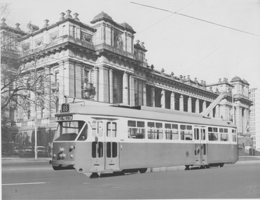
Photograph - Simulation of tram resembling PCC 1041 on Spring St, early 1970s
Photograph of track on Spring St in front of Parliament House with an enlarged photograph of a tram model resembling PCC 1041 (but not bearing its number) positioned and glued onto photograph to simulate its future operation. The model displays the destination "route 88 East Preston".Yields information about planning and publicity for introduction of PCC 1041 and Z class tramcars. Black and white photograph with no note on rearpcc, 1041, tram model, simulation, future opertion, parliament house, route 88, east preston -
 Surrey Hills Historical Society Collection
Photograph - 9 Como Avenue, Surrey Hills, The Street Where You Live Project
Photos documenting this address as part of a photographic series undertaken by volunteer photographers during 2013 and 2014 for The Street Where You Live Project. This was organised through the Surrey Hills Neighbourhood Centre and covered the postcode 3127 in the cities of Boroondara and Whitehorse.These photos provide a snapshot of real estate in the suburbs of Mont Albert and Surrey Hills during a period of rapid change with many properties on large blocks demolished to create higher density residential development or renewal of single dwellings. At particular risk were properties not covered by heritage overlays, especially interwar housing and post 1950's housing. -
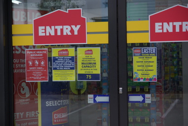 Federation University Historical Collection
Photograph - Photograph - Colour, Social Distancing Signs during the Covid-19 Pandemic, 2020, 06/04/2020
On 12 January, the World Health Organization (WHO) confirmed that a novel coronavirus was the cause of a respiratory illness in a cluster of people in Wuhan City, Hubei Province, China, who had initially come to the attention of the WHO on 31 December 2019. On 3 March, the Reserve Bank of Australia became the first central bank to cut interest rates in response to the outbreak. Official interest rates were cut by 0.25% (25 base points) to a record low of 0.5%. On 12 March, the Federal Government announced a A$17.6 billion stimulus package, the first since the 2008 GFC. he package consists of multiple parts, a one-off A$750 payment to around 6.5 million welfare recipients as early as 31 March 2020, small business assistance with 700,000 grants up to $25,000 and a 50% wage subsidy for 120,000 apprenticies or trainees for up to 9 months, 1 billion to support economically impacted sectors, regions and communities, and $700 million to increase tax write off and $3.2 billion to support short-term small and medium-sized business investment. On 16 March, Premier Dan Andrews and Minister for Health Jenny Mikakos declared a state of emergency for Victoria for at least four weeks. On 19 March, the Reserve Bank again cut interest rates by a further 0.25% to 0.25%, the lowest in Australian history. On 22 March, the government announced a second stimulus package of A$66bn, increasing the amount of total financial package offered to A$89bn. This included several new measures like doubling income support for individuals on Jobseeker's allowance, granting A$100,000 to small and medium-sized businesses and A$715 million to Australian airports and airlines. It also allowed individuals affected by the outbreak to access up to A$10,000 of their superannuation during 2019–2020 and also being able to take an additional same amount for the next year. on the same day Victorian Premier Daniel Andrews announced on 22 March that the state will bring the school holiday forwards to 24 March from 27 March. On 30 March, the Australian Federal Government announced a $130 billion "JobKeeper" wage subsidy program offering to pay employers up to $1500 a fortnight per full-time, part-time or casual employee that has worked for that business for over a year. For a business to be eligible, they must have lost 30% of turnover after 1 March of annual revenue up to and including $1 billion. For businesses with a revenue of over $1 billion, turnover must have decreased by 50%. Businesses are then required by law to pay the subsidy to their staff, in lieu of their usual wages. This response came after the enormous job losses seen just a week prior when an estimated 1 million Australians lost their jobs. This massive loss in jobs caused the myGov website to crash and lines out of Centrelink offices to run hundreds of metres long.The program was backdated to 1 March, to aim at reemploying the many people who had just lost their jobs in the weeks before. Businesses would receive the JobKeeper subsidy for six months. Victoria's "Second Wave" from Ballarat Courier, 05 August 2020 Wednesday, August 5: 725 cases, 15 deaths. A record figure reached yet again. Tuesday, August 4: 439 cases, 11 deaths. New fines introduced for COVID-infected people who aren't home. Monday, August 3: 429 cases, 13 deaths. Premier details mass industry shutdowns in Melbourne. Sunday, August 2: 671 cases, seven deaths as harsh new statewide lockdowns are announced Saturday, August 1: 397 new cases, three deaths Friday, July 31: 627 new cases, eight deaths. Premier says one in four Covid cases not home when checked. Thursday July 30: 723 cases, 13 deaths. Just when it was looking promising, alarming new record set. Wednesday July 29: 295 new cases, nine deaths as new cases drop below 300 for first time in nine days Tuesday July 28: 380 new cases, six deaths as aged care outbreaks continue to climb Monday July 27: 532 new cases as daily cases hits 500 for first time, six deaths Sunday July 26: 459 new cases as double-digit death toll is recorded for first time with 10 deaths Saturday July 25: 357 new cases, five new deaths Friday July 24: 300 cases, six deaths, ADF role expanded to help with contact tracing. Thursday July 23 - 403 cases, five deaths, worst day for fatalities in any state, masks now mandatory Wednesday July 22 - 484 cases, two deaths Tuesday July 21 - 374 cases, three deaths Monday July 20 - 275 cases, one death Sunday July 19 - 363 cases, three deaths, notice that masks will become mandatory in lockdown areas Saturday July 18 - 217 cases, three deaths, final Melbourne public housing tower released from hard lockdown Friday July 17 - 428 cases, three deaths Thursday July 16 - 317 cases, two deaths Wednesday July 15 - 238 cases, one death Tuesday July 14 - 270 cases, two deaths Monday July 13 - 177 cases Sunday July 12 - 273 cases, one death Saturday July 11 - 216 cases, one death Friday July 10 - 288 cases, a national daily record at the time Thursday July 9 - 165 cases, eight of nine Melbourne public housing towers released from hard lockdown Wednesday July 8 - 134 cases, new stage-three restrictions announced for metropolitan Melbourne and Mitchell Shire Tuesday July 7 - 191 cases Monday July 6 - 127 cases, two deaths, NSW border closed Sunday July 5 - 74 cases Saturday July 4 - 108 cases, immediate hard lockdown of nine Melbourne public housing towers Friday July 3 - 66 cases Thursday July 2 - 77 cases Wednesday July 1 - 73 casesColour photographs of social distancing signs during the Covid-19 Pandemic, on Chemist Warehouse in Sebastopol. On 06 April 2020 a maximum of 75 people were allowed in the chemist at one time, and those with syptoms of Covid-19 (fever, cough, shortness of breath) were asked to not enter without phone contact. Upon entering customers were directed to use hand sanitizer, and 1.5 metre markings were placed on the floor to enable legal social distancing.covid-19, corona virus, pandemic, chemist's warehouse, sebastopol, social distancing -
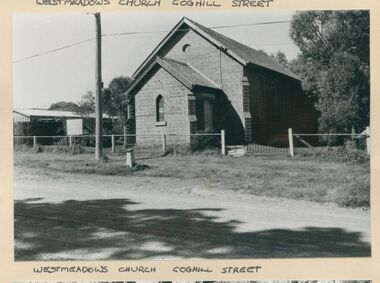 Uniting Church Archives - Synod of Victoria
Photograph
B & W gloss photograph of the exterior of the Westmeadows Uniting Church Coghill Streetwestmeadows, uniting church -
Glenelg Shire Council Cultural Collection
Photograph - Photograph - Casterton Hopsital, c. 1963
Sourced from Casterton Town Hall (Former Shire of Glenelg)Black and white photo. View of part of Casterton hospital. -
 Surrey Hills Historical Society Collection
Photograph - 41 Kennealy Street, Surrey Hills, The Street Where You Live Project
Photos documenting this address as part of a photographic series undertaken by volunteer photographers during 2013 and 2014 for The Street Where You Live Project. This was organised through the Surrey Hills Neighbourhood Centre and covered the postcode 3127 in the cities of Boroondara and Whitehorse.These photos provide a snapshot of real estate in the suburbs of Mont Albert and Surrey Hills during a period of rapid change with many properties on large blocks demolished to create higher density residential development or renewal of single dwellings. At particular risk were properties not covered by heritage overlays, especially interwar housing and post 1950's housing. -
 Ballarat Tramway Museum
Photograph - Black & White Photograph/s, Wal Jack, 10/04/1950 12:00:00 AM
Black and White print contained within the Wal Jack Bendigo and Geelong Album, see Reg Item 5003 for more details. Photo of No. 24 leaving Charing Cross in View St with the destination of Eaglehawk, photo by Wal Jack 10-4-1950. Has the Beehive in the background, a single trucker at Charing Cross, and other buildings. i1 - scan of print in the album i2 - rear of image i3 - scan of negative at 3200dpi added 6/6/2020. On the rear in blue ink "SEC Bendigo No 24 bogie in View St Bendigo 10-4-50" with Wal Jack copyright stamp in the top right hand corner and the number "T216" written in.trams, tramways, bendigo, charing cross, view st, tram 24 -
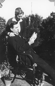 Stawell Historical Society Inc
Photograph, Mr Colin Campbell Heron reclining in chair
Male, Colin Campbell Heron reclining in chair reading with lady overlooking and cat.Two black and white photographs. The photo is of two people a male seated reading and a woman standing with her arm on the mans shoulder. A cat is under the legs of the man.Campbell Heron - 1924stawell portrait -
 Bendigo Historical Society Inc.
Photograph - HARRIS COLLECTION: PHOTOGRAPH ALBUM
Harris collection, Purple velvet covered photograph album with silver decoration and title Our Friends, containing 30 sepia and black & white photographs of people, many by Bendigo & Eaglehawk photographers. Some pages decorated with coloured illustrations of flowers, pages gilt edged.photograph, person, male/ female, bendigo-eaglehawk-photographers -
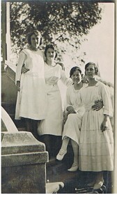 Bendigo Historical Society Inc.
Photograph - FOSTER AND WILSON COLLECTION: PHOTOGRAPH
Black & white photograph of 4 young women standing or sitting on the steps.photograph, portrait, female group, foster & wilson collection, photograph -
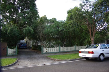
 Eltham District Historical Society Inc
Photograph, Doug Orford, Burkes Bridge across Arthurs Creek, Hurstbridge - Arthurs Creek Road, Hurstbridge, 1991, 1991
From a collection of 35 photos taken by Doug Orford at 35 specific locations along the exact boundary of the then Shire of Eltham.Colour photographbridges, hurstbridge - arthurs creek road, hurstbridge, burkes bridge, arthurs creek -
 Bendigo Historical Society Inc.
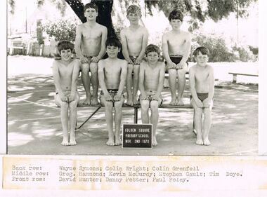
Photograph - GOLDEN SQUARE LAUREL STREET P.S. COLLECTION: PHOTOGRAPH SWIMMING TEAM
Black and white photograph of the Golden Square Primary School Boys Swimming Team, dated Nov. 2nd 1970. Photograph taken under a tree. The boys names are: Wayne Symons, Colin Wright, Colin Grenfell, Greg Hammond, Kevin McCurdy, Stephen Gault, Tim Doye, David Hunter, Danny Potter and Paul Foley.education, primary, golden square laurel st p.s., golden square laurel street p.s. collection - photograph swimming team, wayne symons, colin wright, colin grenfell, greg hammond, kevin mccurdy, stephen gault, tim doye, david hunter, danny potter, paul foley -
Port Melbourne Historical & Preservation Society
Photograph - Portrait, Thomas GRIFFIN, c. 1940
Mayor 1931/32, 1942/43 President of Port Melbourne Football Club 1929-45Black and white portrait photo of Thomas GRIFFIN, Councillor 1929-1950.local government - city of port melbourne, sport - australian rules football, thomas griffin, port melbourne football club, pmfc -
Glenelg Shire Council Cultural Collection
Photograph - Photograph - Steel casing, n.d
Port of Portland Authority Archivesport of portland archives -
 Eltham District Historical Society Inc
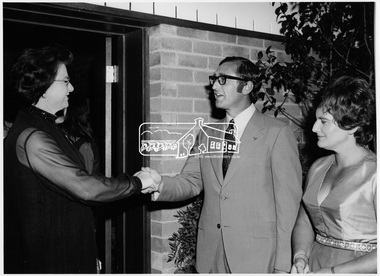
Photograph, Cr. and Mrs. Dreverman greeting a guest at door of West Riding Hall, Henry Petrie Community Centre, on occasion of Buffet Dinner, 7 Jul 1971
Cr. Geoff and Mrs. Dreverman greeting a guest at the door of the West Riding Hall, Henry Petrie Community Centre, Montmorency on occasion of a buffet dinner as part of the Shire of Eltham centenary celebrations. This photo forms part of a collection of photographs gathered by the Shire of Eltham for their centenary project book, "Pioneers and Painters: 100 years of the Shire of Eltham" by Alan Marshall (1971). The collection of over 500 images is held in partnership between Eltham District Historical Society and Yarra Plenty Regional Library (Eltham Library) and is now formally known as'The Shire of Eltham Pioneers Photograph Collection.' It is significant in being the first community sourced collection representing the places and people of the Shire's first one hundred years.Digital imagesepp, shire of eltham pioneers photograph collection, shire of eltham, shire of eltham centenary, henry petrie community centre, centenary celebrations, buffet dinner, cr. g.c. dreverman, mrs. dreverman