Showing 1649 items in the category Documentation with item type Plan
-
 University of Melbourne, Burnley Campus Archives
Plan, Mary Younger, Proposed Outdoor Eating Area, Student Amenities Block, Vic. College of Agriculture & Horticulture, 1996
Plans numbered Scheme 1 - Scheme 7 for proposed outdoor eating area, Student Amenities Block. Possibly by Mary Younger (see B18.0007).mary younger, amenities, vcah, burnley -
 Federation University Historical Collection
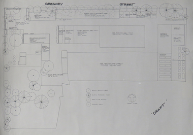
Plan, Ballarat School of Mines Horticulture Centre, Gregory St, Ballarat
Plan for the Gregory Street Horticulture Centre.ballarat school of mines, horticulture, school of horticulture, horticulture building, gregory street, architectural plan -
Glenelg Shire Council Cultural Collection
Plan - Plans / Line Drawings - Port of Portland Slipway, Bilge Blocks Fishing Vessel Seamount Enterprise, Portland, Victoria, 08/11/1990
PORT OF PORTLAND AUTHORITY -
Moorabbin Air Museum
Plan (item) - CAC Collection - Drawing Introduction Sheet Fuel Pump FP30
Issued On Behalf Of Directorate Of Technical Services RAAF -
University of Melbourne, Burnley Campus Archives
Plan, Kirsten Strutt, Design for Mr & Mrs Swan 7 Gascoyne Street Canterbury 3126, c. 1990-2000
Coloured plan by Kirsten Strutt. Scale 1:100.canterbury, kirsten strutt -
Glenelg Shire Council Cultural Collection
Plan - Plan - Port of Portland Slipway Tug Boat 'Buccaneer', 02/10/1989
port of portland -
Moorabbin Air Museum
Plan (item) - C.A.C Winjeel Conversion XP75
-
University of Melbourne, Burnley Campus Archives
Plan, V.C.A.H Burnley Location map, c.1991
Plan of the Campus with buildings named.vcah, burnley campus -
Moorabbin Air Museum
Plan (item) - Bristol Aeroplane 170 schematic drawings, Plug Compt.Centre Plane
Bristol Aeroplane Company Ltd -
Glenelg Shire Council Cultural Collection
Plan - Ship Plan / Mould, n.d
Wooden pattern for mould for boat fitting. Two similar rectangular pieces joined in parallel by two small, similar rectangular pieces, at right angles to the larger rectangles, creating an open box-like shape. Painted white. -
Port Melbourne Historical & Preservation Society
Plan - Water cart used in road construction, Borough of Sandridge, 21 Nov 1870
From a group of maps and plans not required by the Port Melbourne Council Engineering Department in May 1994 and offered at that time to the Port Melbourne Historical Society.Plan of water cart used in road construction including 4 diagrams and scales: signed by Borough Surveyor, Nov 21 1870.built environment - civic, engineering, engineering department - borough of sandridge -
Glenelg Shire Council Cultural Collection
Plan - Plan - Port of Portland Slipway Fishing Vessel 'Gypsy Rose', 20/09/1983
port of portland -
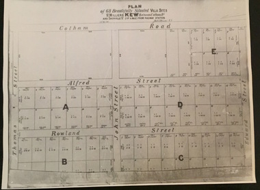 Kew Historical Society Inc
Plan - Subdivision Plan, Plan of 68 beautifully situated villa sites: St Helliers Kew, 196-1973
This work forms part of the collection assembled by the historian Dorothy Rogers, that was donated to the Kew Historical Society by her son John Rogers in 2015. The manuscripts, photographs, maps, and documents were sourced by her from both family and local collections or produced as references for her print publications. Many were directly used by Rogers in writing ‘Lovely Old Homes of Kew’ (1961) and 'A History of Kew' (1973), or the numerous articles on local history that she produced for suburban newspapers. Most of the photographs in the collection include detailed annotations in her hand. The Rogers Collection provides a comprehensive insight into the working habits of a historian in the 1960s and 1970s. Together it forms the largest privately-donated collection within the archives of the Kew Historical Society.A photographic reproduction of a plan in the Vale Collection of the State Library of Victoria. The plan shows lots in a subdivision bordered by Cotham Road; Edward Street; Sackville Street and Thomas Street. The undated plan does not include the land occupied by Bella Vista and Charleville.subdivision plans -- kew (vic), st helliers estate -
Port Melbourne Historical & Preservation Society
Plan - Proposed Lorimer Street realignment, City of Port Melbourne, 28 Oct 1938
Printed map of City of Port Melbourne with proposed Lorimer Street realignment marked in red and blue.Pencilled lower right: Proposed realignment Lorimer St Also 'Request by Council under Sec 523 L. Getch' : (Getel?)engineering - roads streets lanes and footpaths, l getel, l getch -
Port Melbourne Historical & Preservation Society
Plan - Ada Mary A'Beckett Free Kindergarten, Fishermans Bend, Martin & Tribe, Architects, 21 Mar 1949
Martin & Tribe - ArchitectsPlans, Ada Mary A'Beckett Free Kindergarten - final details i.e. kerbing, tanbark, flagpole. 1947.education - kindergartens, garden city, built environment - civic, fishermans bend, ada mary a'beckett, martin & tribe, ada mary a'beckett kindergarten -
University of Melbourne, Burnley Campus Archives
Plan, Nicole Faulkner, Rose Garden 'Banyule', 1989
Planting Plan for 'Banyule', 72 Buckingham Drive, Heidelberg by Nicole Faulkner for Grad. Dip. Horticulture. Sheet 4 of 4, dated November 1989. Scale 1:100.rose garden, nicole faulkner, "banyule", heidelberg -
University of Melbourne, Burnley Campus Archives
Plan (Item) - Plans & elevations, [Bookshop] Plans & elevations Burnley Horticultural College
dairy, student bookshop, burnley horticultural college -
Moorabbin Air Museum
Plan (item) - Power Distribution Box Assembly - Hydraulic Power Cart United Technologies Sikorsky Aircraft
Drawing No.65725-76293 Rev.1 -
Glenelg Shire Council Cultural Collection
Plan - Ship Plan / Mould, n.d
Wooden pattern for mould for boat fittings. Same as 6360 different size, painted gold -
Moorabbin Air Museum
Plan (item) - C.A.C Proposed RA-14 Avon Installation "Sabre" P251 XP.53
-
 Kew Historical Society Inc
Plan - Subdivision Plan, Golf View Estate, c.1922
Pru Sanderson, in her groundbreaking ‘City of Kew Urban Conservation Study : Volume 2 - Development History’ (1988), summarised the periods of urban development and subdivisions of land in Kew. The periods that she identified included 1845-1880, 1880-1893, 1893-1921, 1921-1933, 1933-1943, and Post-War Development. These periods were selected as they represented periods of rapid growth or decline in urban development. An obvious starting point for Sanderson’s groupings involved population growth and the associated economic cycles. These cycles also highlighted urban expansion onto land that was predominantly rural, although in other cases it represented the decline and breakup of large estates. A number of the plans in the Kew Historical Society’s collection can also be found in other collections, such as those of the State Library of Victoria and the Boroondara Library Service. A number are however unique to the collection.The Kew Historical Society collection includes almost 100 subdivision plans pertaining to suburbs of the City of Melbourne. Most of these are of Kew, Kew East or Studley Park, although a smaller number are plans of Camberwell, Deepdene, Balwyn and Hawthorn. It is believed that the majority of the plans were gifted to the Society by persons connected with the real estate firm - J. R. Mathers and McMillan, 136 Cotham Road, Kew. The Plans in the collection are rarely in pristine form, being working plans on which the agent would write notes and record lots sold and the prices of these. The subdivision plans are historically significant examples of the growth of urban Melbourne from the beginning of the 20th Century up until the 1980s. A number of the plans are double-sided and often include a photograph on the reverse. A number of the latter are by noted photographers such as J.E. Barnes.The subdivision advertised as the Golf View Estate in Camberwell included 32 allotments bordering on Glen Iris Road, Smith Street (now Smith Road), St Andries Street and Camberwell Road. In the post-war period in which the subdivision took place, the significance of Camberwell as the ‘Heathiest of Suburbs’ because of the undulating nature of its terrain and its high altitude was promoted. The sales pitch aimed at attracting and selling to ‘Gentlemen’ who could take advantage of the nearby trams, which would take them to the ‘heart of the city’.subdivision plans - camberwell, golf view estate -
Glenelg Shire Council Cultural Collection
Plan - Ship Plan / Mould, n.d
Wooden pattern for mould for boat fitting. Solid cylinder, metal screw protruding from one end, smaller diameter cylinder attached to other end. Painted yellow/orange. -
Port Melbourne Historical & Preservation Society
Plan - Additions, Port Melbourne Town Hall, City of Port Melbourne, 8 Jun 1936
Handrawn and coloured plan included with specifications for additions etc. to supper room at Town Hall, Port Melbourne, 1936.Both notes and plan signed by F.C. Cook, City Engineer - 3rd page of notes, top left hand corner of plan.port melbourne town hall, city engineers, fred cook -
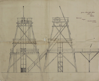
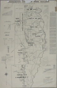 Federation University Historical Collection
Plan, Underground Survey of Mines, Ballarat, 1887, 1887
Printed plan with text down right side and black border, 4 holes top edge and repairsplan, underground survey, robert allen, w. langtree, prince of wales and bonshaw united, bonshaw, south plateau, north plateau, sebastopol plateau, sebastopol star, star of the east, south star, band and albion, owen's freehold, leigh river, yarrowee creek, robert allan, gay's freehold -
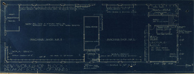 Federation University Historical Collection
Plan, New Workshop Block Ballarat School of Mines
It is not known which building these plans belong to. Since there is a Heat Treatment Room and a number of vices it may be a metalwork room, and may be related to Repatriation classes after World War One. Blueprint of plans for a new workshop at the Ballarat School of Mines. The plan includes a lecture room, bulk store, tool store, heat treatment room, office and two machine shops. Around the machine shops are work benches and vyces (sic)new workshop block, ballarat school of mines, repatriation, buildings -
 Kew Historical Society Inc
Plan - Subdivision Plan, Mayfield Estate, 1927
A number of the plans in the Kew Historical Society’s collection can also be found in other collections, such as those of the State Library of Victoria. A number are however unique to the collection.The Kew Historical Society collection includes almost 100 subdivision plans pertaining to suburbs of the City of Melbourne. Most of these are of Kew, Kew East or Studley Park, although a smaller number are plans of Camberwell, Deepdene, Balwyn and Hawthorn. It is believed that the majority of the plans were gifted to the Society by persons connected with the real estate firm - J. R. Mathers and McMillan, 136 Cotham Road, Kew. The Plans in the collection are rarely in pristine form, being working plans on which the agent would write notes and record lots sold and the prices of these. The subdivision plans are historically significant examples of the growth of urban Melbourne from the beginning of the 20th Century up until the 1980s. A number of the plans are double-sided and often include a photograph on the reverse. A number of the latter are by noted photographers such as J.E. Barnes.The Mayfield Estate subdivision included 14 allotments surrounding Evan Court (now Evans Court) in Toorak. The subdivision adjoined Toorak Road east of Kooyong Road and alerted prospective buyers to how the Toorak Road tram would take them directly to the city. This emphasis on existing transport routes was a feature of subdivisions during a period when car ownership was the preserve of the wealthy. An existing brick villa (‘Mayfield’) is noted as already constructed on lot 13. The subdivision also notes that the lots adjoin land owned by Sir Edward Miller. Today Evans Court extends beyond this subdivision through to Moonga Road.subdivision plans - toorak, mayfield estate, sir edward miller -
 Federation University Historical Collection
Plan, Golden Hind Gold Mine, Poppet Head, 1946
Hand drawing in black and red ink, of Golden Hind Gold Mine Popett Head poppet head, golden hind gold mine, nillumbik, donald mather, mining -
University of Melbourne, Burnley Campus Archives
Plan, School of Primary Agriculture & Horticulture - Burnley, c. 1925-1926
Copy of plan photographed at the Public Records Office Victoria. Central Administration Correspondence Files 1912-1939 ITEM. VPRS 10163/P0003/2. Accomodation Burnley School Part 1. Traced from M.M.B.W. Plan No. 42. Scale 160 ft=1 in. Level Datum L.M.N. Hobson's Bay. Traced by C.E.B.W. 16.02.1926. Additional matter in red and green inserted by F.E.T.C. 09.02.1926. Note by J.J. Rae (Principal). Lists W.C.s (toilets). Shows 1891 Flood Line. Possibly dates from 1925.prov, school of primary agriculture and horticulture, burnely, j.j. rae -
Glen Eira Historical Society
Plan - KOOYONG ROAD, 179, CAULFIELD
A Handrawn, undated and unattributed plan of property at 179 Kooyong Road, Caulfieldcaulfield, kooyong road, plans -
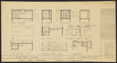 University of Melbourne, Burnley Campus Archives
Plan, N.S. Jemmerson, Specifications for Office and Executive Desks, 1961
Plans. A. Specification for Office Desk - Typiste. No. 53. B. Specification for Executive Desk. No. 43. For Ray Davey, Chief Architect, Public Works Dept. Drawn by A: N.S. Jemmerson; B: R.J.G.ray davey, n.s. jemmerson