-
 Whitehorse Historical Society Inc.
Legal record - Document, Dresden, n.d
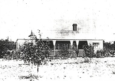
'Dresden', Glebe Street, Forest Hill, home of Julius and Edith Draeger.Photocopy of 'Dresden', Glebe Street, Forest Hill, home of Julius and Edith Draeger. 'Dresden', Glebe Street, Forest Hill, home of Julius and Edith Draeger.draeger, carl julius otto, kendall, june, dresden, glebe street, forest hill, edith florence -
 Port Melbourne Historical & Preservation Society
Plan - Rebuilding library, Liardet Street, Port Melbourne, Linkon Design and Construction, 1987
.01 - Blueprint of 1987 plan for rebuilding library in Liardet Street (2 copies). .02 - Blueprint of 1987 Plan for Library in Liardet St - Electrical Services (2 copies)market reserve, linkon, city of port melbourne engineering dept, port melbourne library, built environment - civic -
University of Melbourne, Burnley Campus Archives
Plan, S. Soerono, Project Xerophytic Garden, 1989
Planting Plan and Coloured Elevation from Pt A to A₁ by S. Soerono, dated 10.11.1989s. soerono, landscape design, xerophytic gardens -
University of Melbourne, Burnley Campus Archives
Plan, Arrangement of Soil Sterilizing Room for New Plant Science Laboratory at Burnley College of Horticulture, c. 1960
Plan by State of Victoria, Dept of Public Works. Drawn by R.M.department of public works -
University of Melbourne, Burnley Campus Archives
Plan, Anthony Mahady, Rear Courtyard Design 1:50, 1998
Set of drawings for Landscape Design '98, Garden Design Theme: Islamic, by Anthony Mahadylandscape design, anthony mahady, islamic design -
Stawell Historical Society Inc
Archive, Cemetery Trust Stawell. Burials 1870 – 1938, Oct 1870 - Mar 16938
Grey/Green No title on cover. Records Fees Paidstawell, cemetery -
Stawell Historical Society Inc
Archive, Callawadda South Mechanics Institute 1898 - 1914, 1898 - 1914
stawell -
Stawell Historical Society Inc
Archive, Powers of Attorney, 1874 - 1877
Green Covered with Faded Red Binding & Corners. Gold Writing on SpineRecord of Powers of Attorneystawell, legal -
Bialik College
Plan (item) - Bialik College, 1970s
Two boxes of architectural plans of proposed Bialik College, 429 Auburn Road, Hawthorn East, created by architects Joshua and Mary Pila, c. 1970s. Box 1: 1970s, Box 2: 1979. Please contact [email protected] to request access to this record.1970s, building and planning -
Stawell Historical Society Inc
Archive, Stawell West Ladies Minute Books & Scrapbook. X4, 1957 - 2007
Cash Book, Minute Books and 2 Scrap booksstawell -
Port Melbourne Historical & Preservation Society
Archive - Alan Mathews and family, 23 Jun 1938
The Mathews family have been in continuous ownership of 395 Howe Parade (was 8 Howe Parade until 1964 when addresses re-assigned), Port Melbourne from 1938 to the present (Sept 2019)Six folders of assorted documents relating to the life of Alan Mathews and his family. Documents relating to the purchase of residence on Howe Parade. The Commissioners of the State Savings Bank of Victoria with Mr J E Mathews Factory Foreman, 2 Eveline Street East Brunswick. Contract of sale of a dwelling House and land 8 Howe Parade Garden City. Contract signed 7.11.1938built environment - domestic, banking, alan mathews -
University of Melbourne, Burnley Campus Archives
Plan, Swan St. Entrance, 1988-1989
Found in file labelled, "Swan St. Entrance" Geoff Olive.(1) Correspondence between Mr Ron Hamilton, Manager, Tram Operations, Eastern Section and Steve Mullany, Lecturer. Includes plan of "Entrance to V.C.A.H. Burnley and Plant Research Institute." (2) Handwritten note dated 5 July 89. (3) Handwritten estimate of costs by Ian W(instone). (4) Photocopy of planting plan. Also see B11.0592. ron hamilton, vcah, burnley campus, steve mullany -
 Federation University Historical Collection
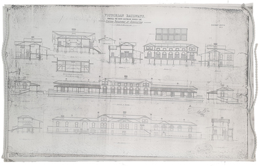
Plan, Copy of a Plan of Serviceton Railway Station Building, 1888
The Serviceton Railway Station was completed in 1889 , with the Colony of Victoria and the Colony of South Australia sharing the cost. Ut was at Serviceton the the Victorian rail line and the Adelaide-Wolseley railway line of South Australia joined. The Railway Station included customs offices which were no longer necessary after the Federation of Australian States in 1901. ( https://en.wikipedia.org/wiki/Serviceton,_Victoria, accessed 30 August 2021)Copy of plan for the Serviceton Railway Linerailway, servicetone railway station, plan, serviceton -
Glenelg Shire Council Cultural Collection
Plan - Ship Plan / Mould, n.d
Wooden pattern for mould for boat fitting. Cylinder, smaller diameter at each end; made in two pieces, held together by wooden dowels. Outside of each half painted white, inside unpainted.Back: '2 OF BRONZE' - pencil -
Stawell Historical Society Inc
Archive, Education Department of Victoria, Concongella State School No 1136 Pupils Register 1877-1892, 1877
Donated from Back to Concongella CommitteeLarge Black Plastic Folder with clear pocketsPupils Register Book education, students -
 Mission to Seafarers Victoria
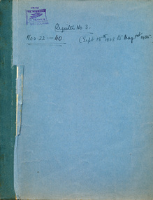
legal record (item) - Register, marriages, Register no 3, Nos 22 to 40 (Sept 15th 1923 to May 1st 1935, 1923
All the weddings performed in the St Peter Chapel from September 1923 to May 1935 are documented in the register. Each page records the necessary information for the marriage to be registered legally in the Commonwealth of Australian.The register is a record of the weddings conducted at the St Peter Chapel between the 15th of September, 1923 to the 1st of March, 1935.Handwritten in black ink on front cover: REGISTRATION NO 3. / NOS 22- 40 (SEPT 15TH 1923 TO MAY 1ST 1935. Stamped in purple ink in top left corner: FROM / THE MISSION / TO SEAMEN / MELBOURNE.wedding, mission to seafarers, seamen's mission, mission to seamen, st peter chapel, marriage, register, record, flinders street, dio-marriages, dio-archives -
Glenelg Shire Council Cultural Collection
Plan - Ship Plan / Mould, n.d
Wooden pattern for mould for boat fitting. Rectangular piece with one rounded end, attached to larger rectangular piece, rounded at one end, tapering into a narrow rectangular 'neck'. A hump attached to 'neck' section at right angles. Painted white. -
 Kew Historical Society Inc
Plan - Subdivision Plan, Rimington Nursery Estate, 1949
Pru Sanderson, in her groundbreaking ‘City of Kew Urban Conservation Study : Volume 2 - Development History’ (1988), summarised the periods of urban development and subdivisions of land in Kew. The periods that she identified included 1845-1880, 1880-1893, 1893-1921, 1921-1933, 1933-1943, and Post-War Development. These periods were selected as they represented periods of rapid growth or decline in urban development. An obvious starting point for Sanderson’s groupings involved population growth and the associated economic cycles. These cycles also highlighted urban expansion onto land that was predominantly rural, although in other cases it represented the decline and breakup of large estates. A number of the plans in the Kew Historical Society’s collection can also be found in other collections, such as those of the State Library of Victoria and the Boroondara Library Service. A number are however unique to the collection.The Kew Historical Society collection includes almost 100 subdivision plans pertaining to suburbs of the City of Melbourne. Most of these are of Kew, Kew East or Studley Park, although a smaller number are plans of Camberwell, Deepdene, Balwyn and Hawthorn. It is believed that the majority of the plans were gifted to the Society by persons connected with the real estate firm - J. R. Mathers and McMillan, 136 Cotham Road, Kew. The Plans in the collection are rarely in pristine form, being working plans on which the agent would write notes and record lots sold and the prices of these. The subdivision plans are historically significant examples of the growth of urban Melbourne from the beginning of the 20th Century up until the 1980s. A number of the plans are double-sided and often include a photograph on the reverse. A number of the latter are by noted photographers such as J.E. Barnes.The house lots in the Rimington Nursery Estate were advertised for sale on Saturday 22nd October 1949. The nine lots in the sale were in Stoke Avenue and Burke Road. Mathers & McMillan of 136 Cotham Road, Kew, offered the lots for sale. [The final sale of lots within the Rimington Nursery Estate occurred as late as 1958.]subdivision plans - kew, rimington nursery estate, monist victor road - kew (vic.) -
Stawell Historical Society Inc
Archive, Presbyterian Church Committee Meeting Minute Book 1860 - 1901, 1860 - 1901
Used by Commitee of Presbyterian Church Meeting Minutes 2-4-1860 to 24-6-1901 Also Members of Committee listed for Years 1891, 1892, 1893, 1894, 1895 Also Collectors Listed for Years 1873 Through to June 1890Black Cover with Gold Writingstawell, religion -
University of Melbourne, Burnley Campus Archives
Plan (Item) - Cul-de-sac planting design, 2020
cul-de-sac, planting design, john rayner -
 Stawell Historical Society Inc
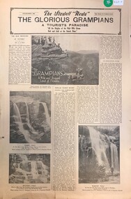
Archive - Newspaper Supplement, The Stawell News: The Glourious Grampians A Tourist Paradise 1938
Grampians LandmarksFour (4) Pages on Tourist Sights in the Grampianstourism -
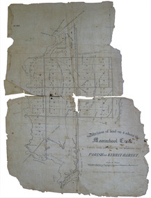 Federation University Historical Collection
Plan, Eugene Bellairs, Moorabool Creek, Parish of Kerrit-Bereet, 01/08/1855
Plan of the Moorabool Creek on the Melbourne Roadmoorabool, kerrit-bareet, moorabool creek, eugene bellairs -
Ringwood and District Historical Society
Legal record - Conditions of Sale (C.E.Carter), Lot 18 - Bayswater, Lot 5 - Fern Tree Gully, Lot 13 - Bayswater, Lot 1 - Ringwood, Lot 26 - Ringwood, Various Vendors and C.E.Carter, 1941
Particulars and Conditions of Sale of Property , from various Vendors to C.E.Carter. -
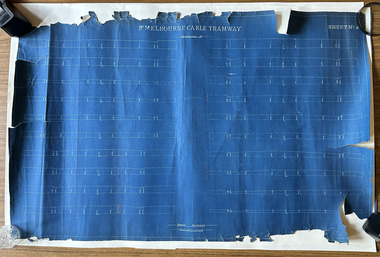 Port Melbourne Historical & Preservation Society
Plan, Pt Melbourne Cable Tramway, 1890s
One of three sheets of blueprints showing street configuration in Beach Street and Sandridge Road along Port Melbourne cable tram route. Indistinguishable signature of 'George ------ Esq., lower rightNotations in red crayon or penciltransport - tramways, transport - roads -
Port Melbourne Historical & Preservation Society
Plan - Bus Shelter, Lorimer Street, Fishermans Bend, Engineering Department, City of Port Melbourne: A N B, 23 Mar 1942
Working drawings for the construction of bus shelter in Lorimer Street, Fishermens Bend, 1942. Preliminary design only. Subtitled "Design B" "Design A"Signed: Approved " ":Drawn: A. N. B.transport - bus, built environment - civic, fishermans bend, local government - city of port melbourne -
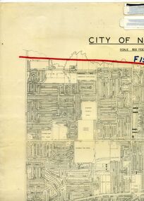 Whitehorse Historical Society Inc.
Legal record - Map, F19 freeway, 1/12/1977 12:00:00 AM
Approximate alignments of F19(Eastern) Freeway, F9 and Scoresby Freeway, marked on 1973 edition of City of Nunawading map,Approximate alignments of F19(Eastern) Freeway, F9 and Scoresby Freeway, marked on 1973 edition of City of Nunawading map, Scale 800 ft = 1 inch.Approximate alignments of F19(Eastern) Freeway, F9 and Scoresby Freeway, marked on 1973 edition of City of Nunawading map, freeways, city of nunawading, eastern freeway, scoresby freeway -
Moorabbin Air Museum
Archive (Item) - Box Baa 21 Boeing (Gaf / Asta) Collection
Description: - JINDIVIK DRAWINGS B3B-86-551 TO B3B-86-615 Level of Importance: National. Historical Details: DAP/GAF/ASTA constructed many overseas designs under licence in Australia (Beaufort, Beaufighter, Lincoln, Canberra and F18) however they also designed and constructed a number of significant local designs that were successful in oversea's markets includi -
Port Melbourne Historical & Preservation Society
Plan - Alterations, Port Melbourne Town Hall, Bay Street, Port Melbourne City Council, 1930s
Plan on tracing paper of proposed alterations to Town Hall 1930s.port melbourne town hall, built environment - civic, engineering department - city of port melbourne, bay street, city engineers, fred cook -
Glenelg Shire Council Cultural Collection
Plan - Ship Plan / Mould, n.d
Wooden pattern for mould for boat fitting. Solid cylinder, metal screw protruding from one end, smaller diameter cylinder attached to other end. Painted yellow/orange. -
 Kew Historical Society Inc
Plan - Subdivision Plan, Windella-Darnley Subdivision, Studley Park, 1920s
Subdivision plans are historically important documents used as evidence of the growth of suburbs in Australia. They frequently provide information about when the land was sold on which a built structure was subsequently constructed as well as evidence relating to surveyors and real estate and financial agents. The numerous subdivision plans in the Kew Historical Society's collection represent working documents, ranging from the initial sketches made in planning a subdivision to printed plans on which auctioneers or agents listed the prices for which individual lots were sold. In a number of cases, the reverse of a subdivision plan in the collection includes a photograph of a house that was also for sale by the agent. These photographs provide significant heritage information relating house design and decoration, fencing and household gardens.Version 2 of two subdivision plans (the earlier is 2016.0305.1) for the section of Studley Park Road near the Junction on the south side. Named in the subdivision are the mansions of Darley and Windella (now demolished). Before the subdivision of Darley and Windella, both houses fronted Studley Park Road. Both houses appear to be advertised as lots in the subdivision. Bisecting the subdivision is a street, Antrim Avenue that was never constructed. A street, which was subsequently constructed in this vicinity, was Merrion Place, which now runs between Studley Park Road and Highfield Grove. There are 13 proposed lots in this subdivision in contrast to the earlier plan. This resulted from larger lots being proposed for Studley Park Road.subdivision plans - kew, studley park, windella, darnley, antrim avenue -- kew (vic.), studley park road -- kew (vic.), merrion place -- kew (vic.), merrion grove -- kew (vic.), highbury grove -- kew (vic.)