-
 Stawell Historical Society Inc
Archive, Callawadda Progress Association 1952 – 1963, 1952 - 1963
stawell -
Kew Historical Society Inc
Archive (collection) - Irena Higgins : Fol.9 Disability & Mental Health, 1951-2008
Irena Higgins (1951-2014) > Barbara Higgins (2015) > Kew Historical Society (2015)Professional papersCollection > Series > Sub-series (folder) > ItemKew Cottages Parents Association [Folder 1/2] - Members | Letter to Irena Higgins (Social Worker) re 50th anniversary of KCPA (2007) | The formation and developments of KCPA (Irena Higgins, 1960) | Parents letter to Irena Higgins | Talk re Guilt feelings of parents (Irena Higgins) | Message from Ethel Temby (Committee) | The use of a small group in social action and the role of the professional social worker in it | A couple of pages on what the Parents Association does | Role of the social workerdepartment of health (vic.), mental hygiene authority (vic.), mental health authority (vic.), health commission of victoria, community services victoria, department of health and community services, department of human services, kew cottages, kew children’s cottages, kew training centre, kew residential servicesdepartment of health (vic.), mental hygiene authority (vic.), mental health authority (vic.), health commission of victoria, community services victoria, department of health and community services, department of human services, kew cottages, kew children’s cottages, kew training centre, kew residential services -
Warrnambool and District Historical Society Inc.
Archive (Collection) - A.A. Briggs collection of ledgers and personal papers, Arthur Briggs, 1893-1937
Administrative records of A. A. Briggs, Warrnambool accountant, real estate agent, insurance and commission agent donated to the Warrnambool and District Historical Society, source and date unknown byadministrative records of a Warrnambool businessmanNine ledgers and four folders of documents held in A3 archival boxesHandwritten administrative records and personal papers of nine ledgers and four foldersa.a. briggs warrnambool, victorian alliance, atlas assurance company, warrnambool hospital, warrnambool permanent building societya.a. briggs warrnambool, victorian alliance, atlas assurance company, warrnambool hospital, warrnambool permanent building society -
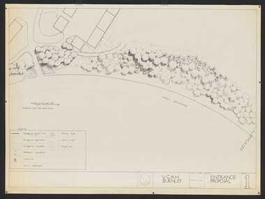 University of Melbourne, Burnley Campus Archives
Plan, Entrance Proposal, 1987-1988
Plans for Entrance from Yarra Boulevard. (1) Tracing paper and paper copies, Entrance Proposal Drawing No. 1. V.C.A.H. Burnley, Aug '87 by R.C., Planting Plan. Tracing paper and paper copies V.C.A.H. Burnley 28.9.88 by JK.vcah, burnley -
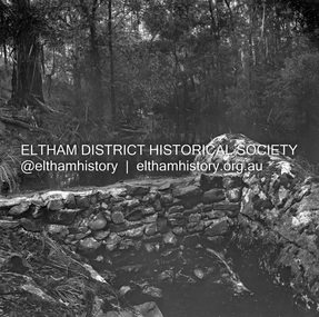
 Eltham District Historical Society Inc
Negative - Photograph, Russell Yeoman, Oxley Bridge, Henley Road, Kangaroo Ground, c.1970
Roll of 35mm black and white negative film, 4 of 7 strips and corresponding B&W printIlford HP4bridge, bridges, watsons creek, kangaroo ground, bend of islands, henley road -
Glenelg Shire Council Cultural Collection
Negative - NEgative - Portland Botanic Gardens and Lifeboat Shelter, c. 1934
NEGATIVE FOR BLACK AND WHITE PHOTOGRAPH. Portland Botanic Gardens. The Portland Lifeboat shelter is visible from the front view, showing plaque.negative, portland lifeboat, botanic gardens -
Kew Historical Society Inc
Archive (Sub-series) - Subject File, CAMERON, Donald, 1958
Various partiesReference, Research, InformationSecondary Values (KHS Imposed Order)Subject file containing a newspaper article/clipping on an exhibition by the Kew artist Donald Cameron. Cameron’s address is given as Grandview Terrace, Kew. The file also contains postcards promoting the exhibition.donald cameron, artists -- kew (vic.)donald cameron, artists -- kew (vic.) -
 Federation University Historical Collection
Plan, Smythesdale, County of Grenville, 01/12/1892
This plan is associated with former Ballarat School of Mines Student Richard Squire (1875-1876). Gift of the Squire FamilyA plan showing the Borough of Smythesdale, Smythesdale, Browns and Scarsdale, allotments, water reserve, Timber reserve, Nintingbool Pre-emptive Right, Reserve for public gardens, Reserve for Cricket Ground, Reserve for Reservoirsmythesdale, scarsdale, browns, yarrowee, carngham, samuel barlett, sheridan, wrigley, p. land, r. simpson, d. davis, nintingbool, mclachlan, a. mclachlan, c. taylor, w. c. smith, d. davies, w. williams, m. jones, t. mcgurk, r. selkirk, a. mooney -
Stawell Historical Society Inc
Archive, Borough of Stawell Pound Book 1925 -1927, 11/6/1925 - 25/3/1927
Green Book with Leather SpinePound keepers Book Borough of Stawellstawell, animals -
Federation University Historical Collection
Plan - Mines, Plan of the Sebastopol Plateau Mines
Small printed plan of the Sebastopol Plateau Mines, including Don Co, New Koh-i-nor, Northern Star Co, Band and Loch Co, Star of the East Co, South Star Co, Gay Star Co, Central Plateau Co, South Star Extended, Sebastopol NO 1, Prince of Wales Co, Prince of Wales and Bonshaw United. Verso is an advertisement of r Ballarat Hardware Co.f.w. holst, sharebrokers, cgt, sebastopol plateau, don co, new koh-i-nor, northern star co, band and loch co, star of the east co, south star co, gay star co, central plateau co, south star extended, sebastopol no 1, prince of wales co, prince of wales and bonshaw united, ballarat hardware co, f.w. holst -
Stawell Historical Society Inc
Archive - Book, Stawell Shire, Registration Of Residence Sites 20-8-1900 - 22-9-1904, 1900
Residence Area Miners Right Mining used by Stawell ShireVery Large Burgandy Leather Ledger with marbling on inside cover. Red Spine and Corners IndexedRegister of Residence Area Book 6Plocal government, miners right -
Stawell Historical Society Inc
Archive, Hospital & Benevolent Asylum Subscriptions 1914 – 1921, 1914 - 1921
Badly Faded outer cover. Suede Bound with one corner missingCashbookstawell, hospital, medical -
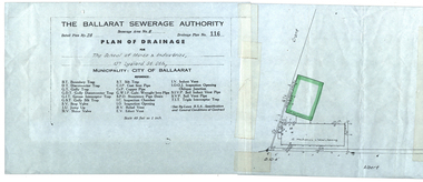 Federation University Historical Collection
Plan, Ballarat School of Mines Plan of Drainage, 1980?
Photocopied Sewerage Plan for Albert Street Scale 1: 480ballarat school of mines, ballarat sewerage authority, museum, welding shop, machine shop, ballarat junior technical school, plumbing -
Stawell Historical Society Inc
Archive, Lady Brooks Kindergarten Subsidy Pupil Enrolments & Teachers, Feb 1948 - April 1988
Register Containing the Children Enrolled. Lady Brooks Kindergarten Sloane St Stawell plus list of teachers and StudentsRegister of Children enrolled to enterstawell, education -
 Ballarat Tramway Museum
Negative, Wal Jack, mid to late 1940's
Negative and Digital images of the Wal Jack Geelong Negative file of the Geelong 18 turning from Ryrie into Malop Streets. In the background is the R. White shoe store at the National Mutual building Coles, Ezywalkin Shoes, Moopers, and other shops. Note the set of bar traffic lights at this location. Photo mid to late 1940's. trams, tramways, geelong, ryrie st, malop st, traffic lights, tram 18 -
 Federation University Historical Collection
Plan, Shewing the workings of the Kuboid Quartz Gold Mining Company, Sulky Gully, not dated
Hand drawn plan with red and blue shading showing the workings of the Kuboid Quartz Gold Mining Cokuboid quartz gold mining company, gold mining, sulky gully -
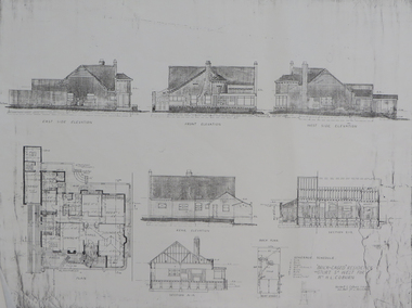 Federation University Historical Collection
Plan - Plan (copy), 'Brick cased Residence 1515 Sturt Street West for Mrs H.L. Coburn, by H. Leslie Coburn, not dated
Ballarat born Herbert L. Coburn grew up to be a renowned Ballarat architect, practising from 1905 to 1956. He taught Architecture and Building Construction at the Ballarat School of Mines (SMB) from 1918, resigning in 1948 due to ill health.Copy of a plan by H.L. Coburn. It includes a front, west, east and rear elevation; ground plan, block plan; and layout plan. herbert l. coburn, h.l. coburn, coburn, architecture, herbert coburn, architectural plan -
 Kew Historical Society Inc
Plan - Subdivision Plan, Myrtle Park Estate, City of Camberwell, 1916
The Kew Historical Society collection includes almost 100 subdivision plans pertaining to suburbs of the City of Melbourne. Most of these are of Kew, Kew East or Studley Park, although a smaller number are plans of Camberwell, Deepdene, Balwyn and Hawthorn. It is believed that the majority of the plans were gifted to the Society by persons connected with the real estate firm - J. R. Mathers and McMillan, 136 Cotham Road, Kew. The Plans in the collection are rarely in pristine form, being working plans on which the agent would write notes and record lots sold and the prices of these. The subdivision plans are historically significant examples of the growth of urban Melbourne from the beginning of the 20th Century up until the 1980s. A number of the plans are double-sided and often include a photograph on the reverse. A number of the latter are by noted photographers such as J.E. Barnes.The ‘Myrtle Park Estate’ was a subdivision bounded by Victoria Road (now Lansdowne Street), Buchanan Avenue and Dight Avenue. Other streets that were created by the subdivision included Eurolie Street, Boorahman Street and Moody Street (now Sylvan Street). The Estate took its name from Myrtle Park (later changed to Macleay Park), which had been created in 1923 by Camberwell Council. The Park adjoined the southeast corner of the new subdivision. The Estate included 74 regular allotments characterised by narrow frontages and long blocks. Confusion may have greeted prospective purchasers as the Estate was advertised in the daily newspapers as being in East Kew, rather than in Camberwell, where it was at that stage located.subdivision plans - balwyn, myrtle park estate - camberwell [surrey hills] -
 Kew Historical Society Inc
Plan - Subdivision Plan, 6 Choice Residential Allotments: East Kew, 1932
Prue Sanderson, in her groundbreaking ‘City of Kew Urban Conservation Study : Volume 2 - Development History’ (1988), summarised the periods of urban development and subdivisions of land in Kew. The periods that she identified included 1845-1880, 1880-1893, 1893-1921, 1921-1933, 1933-1943, and Post-War Development. These periods were selected as they represented periods of rapid growth or decline in urban development. An obvious starting point for Sanderson’s groupings involved population growth and the associated economic cycles. These cycles also highlighted urban expansion onto land that was predominantly rural, although in other cases it represented the decline and breakup of large estates. A number of the plans in the Kew Historical Society’s collection can also be found in other collections, such as those of the State Library of Victoria and the Boroondara Library Service. A number are however unique to the collection.Subdivision plans are historically important documents used as evidence of the growth of suburbs in Australia. They frequently provide information about when the land was sold on which a built structure was subsequently constructed as well as evidence relating to surveyors and real estate and financial agents. The numerous subdivision plans in the Kew Historical Society's collection represent working documents, ranging from the initial sketches made in planning a subdivision to printed plans on which auctioneers or agents listed the prices for which individual lots were sold. In a number of cases, the reverse of a subdivision plan in the collection includes a photograph of a house that was also for sale by the agent. These photographs provide significant heritage information relating house design and decoration, fencing and household gardens.The mansion Woodlands in Harp Road, East Kew suffered the death of a thousand cuts. In its case, the cuts were subdivisions. Previous subdivisions of the mansion and its grounds were given titles such as ‘The Eastlawn Estate’ (MAP.0055), whereas at the end, the subdivision called it as it was, naming itself the ‘final section of the Woodlands Estate’ when it was put up for auction in 1932. The emphasis in the promotion of the subdivision was that it provided purchasers with splendid opportunities ‘to build modern homes in select, well established modern surroundings’. As with other subdivisions in the interwar period, transport links were emphasised. The six residential lots cut Woodlands off from Harp Road. When the vendor, Louisa Rachel Preston Hill, was to die at Woodlands in 1937 aged 86 her address was given as Normanby Road.subdivision plans - kew, woodlands estate -
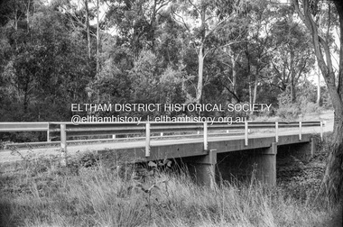
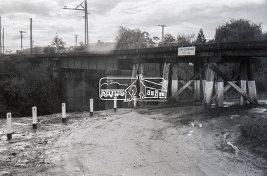
 Eltham District Historical Society Inc
Negative - Photograph, J.A. McDonald, Hurstbridge Water Scheme, 11 May 1961
Downstream view of wall in creek and leak 11 May 1961 http://wikimapia.org/10473910/Running-Creek-ReservoirRecord of various Shire of Eltham infrastructure works undertaken during the period of 1952-1962 involving bridge and road reconstruction projects, sometimes with Eltham Shire Council Project Reference numbers quoted. It was during this period that a number of significant improvements were made to roads and new bridges constructed within the shire that remain in place as of present day (2022). In many situations, the photos provide a tangible visible record of infrastructure that existed throughout the early days of the Shire. The album was put together by or under the direction of the Shire Engineer, J.A. McDonald.infrastructure, road construction, shire of eltham, 1961-05-11, hurstbridge water scheme -
University of Melbourne, Burnley Campus Archives
Plan, Caroline Le Souef, Plan of the Gardens of the Zoological and Acclimatisation Society of Victoria, Royal Park, melbourne, 1877
Appears to be based on the design by Alfred Lynch in 1861 see B17.0076. From ' Little Worlds: Australian Zoological Gardens Part III UWA. Also see B18.0029 Similar plan.Copy of plan from the 'Proceedings of the Zoological and Acclimatisation Society of Victoria, Vol 4, 1877. Drawn by Caroline Le Souef and reproduced in the early Melbourne Zoo guides.caroline le souef, alfred lynch, zoological and acclimatisation society of victoria, royal park, g. purchas -
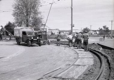 Ballarat Tramway Museum
Negative, Wal Jack, Oct. 1951
Yields information about the relay of the track at the corner of Main Road and Barkly St.Negative and Digital images of the Wal Jack Ballarat Negative file of trackwork to relay the outer rail at the corner of Barkly St and Main Road. Shows the methodology of the work. Has the compressor connected to the overhead in the view. Done at the same time as Bridge St and Main Road - see Reg Item 7731? See Reg Item 5294 for the first tram over the curve - 21/10/1951trams, tramways, main road, barkly st, trackwork, track repairs, welding truck, rails -
Port Melbourne Historical & Preservation Society
Plan - Landscaping Westport Reserve, Port Melbourne, Graeme Bentley, Apr 1990
Plans for landscaping to complement Sandridge Life Saving ClubWorking drawings for landscaping Westport Reserve, Port Melbourne, 5pp, 1990'received 07 Jun 1991'natural environment - beaches and foreshore, westport reserve, bentley, graeme -
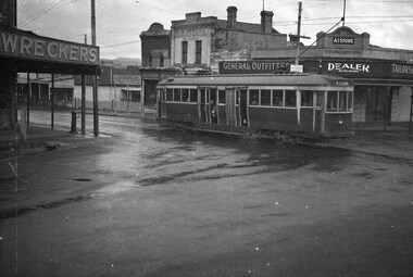 Ballarat Tramway Museum
Negative, Wal Jack, late 1945 early 1946
Yields information about the appearance of the ex Melbourne bogie trams during the initial period of operations in Ballarat and the appearance of the Humffray St and Main Road intersection.Negative and Digital image of the Wal Jack Ballarat Negative file of bogie car, 22 at the corner of Main Road and Humffray St, late 1945/ early 1946 on a very wet day. Tram has the destination of Mt Pleasant. In the background are sores for "A I Store - dealer - will buy anything, Tailors General Outfitters, W. N. Symons Plumber, a hair dresser and a "wrecker" See Reg Item 2882 for a 1958 photo. trams, tramways, main road, mt pleasant, humffray st, tram 22 -
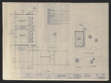 University of Melbourne, Burnley Campus Archives
Plan, VCAH Burnley Proposed Plant Laboratory, 1989
This must have been put out for tender. 1. Site Plan Floor Plan Job No. 89038. Drawing No. SKA001 by Godfrey and Spowers Australia Pty. Ltd. Scale 1:100, 1:200 X 4. 2. Proposed Laboratories & Offices at Swan Street, Richmond for VCAH-Burnley. College of Hporticulture: Floor Plan, Section A-A, Elevation 1, 2, 3 and $. Sheet No. 8952 WD2 by Fooks Martin Sandow Pty Ltd. Scale 1:100vcah, burnley, laboratory -
 Kew Historical Society Inc
Plan - Subdivision Plan, Jas R Mathers Son & McMillan, East Kew Tramway Estate, 1915
Pru Sanderson, in her groundbreaking ‘City of Kew Urban Conservation Study : Volume 2 - Development History’ (1988), summarised the periods of urban development and subdivisions of land in Kew. The periods that she identified included 1845-1880, 1880-1893, 1893-1921, 1921-1933, 1933-1943, and Post-War Development. These periods were selected as they represented periods of rapid growth or decline in urban development. An obvious starting point for Sanderson’s groupings involved population growth and the associated economic cycles. These cycles also highlighted urban expansion onto land that was predominantly rural, although in other cases it represented the decline and breakup of large estates. A number of the plans in the Kew Historical Society’s collection can also be found in other collections, such as those of the State Library of Victoria and the Boroondara Library Service. A number are however unique to the collection.The Kew Historical Society collection includes almost 100 subdivision plans pertaining to suburbs of the City of Melbourne. Most of these are of Kew, Kew East or Studley Park, although a smaller number are plans of Camberwell, Deepdene, Balwyn and Hawthorn. It is believed that the majority of the plans were gifted to the Society by persons connected with the real estate firm - J. R. Mathers and McMillan, 136 Cotham Road, Kew. The Plans in the collection are rarely in pristine form, being working plans on which the agent would write notes and record lots sold and the prices of these. The subdivision plans are historically significant examples of the growth of urban Melbourne from the beginning of the 20th Century up until the 1980s. A number of the plans are double-sided and often include a photograph on the reverse. A number of the latter are by noted photographers such as J.E. Barnes.The East Kew Tramway Estate was a subdivision of two separate parcels of land between Adeney Avenue and Normanby Road. The larger section included 54 lots facing Adeney Avenue, Argyle Road, and Campbell, Hunter and Wishart Streets. [Hunter and Wishart Streets were created as part of the subdivision.] A further 17 allotments faced Normanby Road, Hubert and Campbell Streets. [The name of Hubert Street was later to be changed to Cecil Street.] The promotion of the sale referred to the advantages of living between two tram routes, in High Street and Cotham Road. On the plan, quaintly drawn trams mark these routes. Also on the plan is the route of part of the Outer Circle [Railway] Line.east kew tramway estate, subdivision plans - east kew -
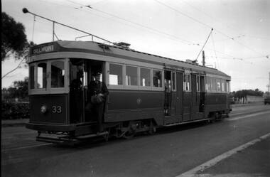 Ballarat Tramway Museum
Negative, 1950's
Yields information about Geelong trams in the late 1940's on the Belmont Line.Negative only - of the bogie tram Geelong No. 33 on the Belmont line with conductor on the footstep of the tram with the driver alongside. Tram has the destination of Belmont. No date information.trams, tramways, geelong, belmont, crews, tram 33 -
Glen Eira Historical Society
Plan - a'Beckett Street, 11, East St Kilda
A hand drawn site and floor plan of a building subdivided into 3 flats at 11 a'Beckett Street, East St Kilda; undated but prior to November 2010 by person unknowna’beckett street, east st kilda, flats, plans, garages, outbuildings, residential development -
 Eltham District Historical Society Inc
Negative - Photograph, Russell Yeoman, Plenty River railway bridge, near Para Road, Greensborough, c.1970
Part of a slide show presentation "Bridges & Waterways of the Shire" by Russell Yeoman to the 13 September 1989 Society meeting. The presentation included slides of historic photos from the Shire of Eltham Pioneers collections as well as several recent views.Roll of 35mm black and white negative film, 4 of 7 stripsIlford HP4bridge, greensborough, para road, plenty river, railway bridge -
Port Melbourne Historical & Preservation Society
Plan - Princes Pier Cafe, Port Melbourne
Cafe belonged to donor's parents.24 Black & white digital images & 2 coloured images of Princes Pier Cafeprince's pier cafe