-
 Moorabbin Air Museum
Plan (item) - Bristol Aeroplane 170 schematic drawings, Assembly of Auxiliary Control Box
Bristol Aeroplane Company Ltd -
Glenelg Shire Council Cultural Collection
Plan - Plan / Line Drawing - Portland Harbour Trust slipway - bilge blocks steel fishing vessel 'Craig Min', 26/05/1987
Front: '41' - black texta, top right cornerport of portland -
 Eltham District Historical Society Inc
Negative - Photograph, J.A. McDonald, Inspection of storm damaged Abraham house at Kangaroo Ground, c. May 1962
Showing the effect of a wind storm that destroyed the house circa May 1962.. The Abraham family owned land near the Aqueduct and east of Nicholas Lane at Kangaroo Ground (based on photos, at or near 40 Nicholas Lane).Record of various Shire of Eltham infrastructure works undertaken during the period of 1952-1962 involving bridge and road reconstruction projects, sometimes with Eltham Shire Council Project Reference numbers quoted. It was during this period that a number of significant improvements were made to roads and new bridges constructed within the shire that remain in place as of present day (2022). In many situations, the photos provide a tangible visible record of infrastructure that existed throughout the early days of the Shire. The album was put together by or under the direction of the Shire Engineer, J.A. McDonald.1962-05, abraham house, kangaroo ground, nicholas lane, property damage, storm damage, building surveyor, george e. newton -
University of Melbourne, Burnley Campus Archives
Plan, Business Services, Burnley Campus, 27.11.2020
plan of burnley campus, university of melbourne -
 Ballarat Tramway Museum
Negative, Geoff Grant, 19/06/1955 12:00:00 AM
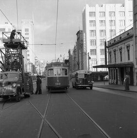
Negative No. N336 and black and white print made by a laser printer (stored in folder ) of fitters, overhead crews lining up the overhead at the Russell St. crossover. Has W6 988 in the photo, along with tower wagon 8 and bus AT 064 alongside. In view is Richardson's Wine and spirit store, Normans, Sharpes and Patersons. Photo taken 19/6/1955. Geoff Grant's envelopes notes that the picture was subsequently published by the Melbourne Herald on 20/6/1955. Negative scanned hi res and imaged updated 22/5/2020.trams, tramways, melbourne, bourke st, russell st., testing overhead, commissioning, tram w6 988 -
 Ballarat Tramway Museum
Negative, Geoff Grant, 19/06/1955 12:00:00 AM
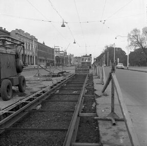
Negative No. N326 and black and white print made by a laser printer (stored in folder ) of view looking along the new track in Nicholson St. Fitzroy, with W6 988 in background by the Exhibition Crossover. Photo shows nature of track construction at this portion of the future East Brunswick, Blyth St. line, an air compressor and the wood/metal barriers to protect roadworks in use at the time. Buildings along the east side of Nicholson St. in background, cable winding house at Gertrude St. can just be seen. Date of photo 19/6/1955. Negative scanned hi res and imaged updated 21/5/2020.trams, tramways, melbourne, nicholson st., east brunswick, track construction., tram w6 988 -
Glen Eira Historical Society
Plan - Centre Road, Bentleigh
Two copies of a one page printed advertisement for the auction of six shops on Centre Road, Bentleigh near Jasper Road to be held on 07/03/1950. The advertisement includes a plan (51mm x 127mm) of the sitesmeldrum w, centre road, bentleigh, plans, advertisements -
 Falls Creek Historical Society
Plan - Leases of part of Falls Creek Tourist Area, 1984
Bob (Herman) Hymans (a former Pilot in the Royal Netherlands Navy was born in Bloemendaal, Holland on 30th September 1922. During World War II he fought against the Japanese in the Dutch East Indies (now Indonesia) and was imprisoned in Changi and on the Burma Railway. After gaining qualifications as a Ski Instructor, Bob arrived in Falls Creek in May 1950. Working as an Instructor and Supervisor at Bogong Lodge, Bob decided his future was in accommodation. He was successful in negotiating an indenture for land from the State Electricity Commission (SEC). It took Bob two years to build his Grande Coeur Chalet but, tragically, it was burned down in August 1961. Bob also built the first Chairlift in Australia. This was a single chairlift and the structure was built from wooden electricity poles. He was constantly full of new ideas and proposals for the village. Bob Hymans died on 7th May 2007. This Collection of documents and letters tells the story of Bob’s endeavours to develop Falls Creek into the ski village it is today. This map is significant because it documents boundaries of early leases in Falls Creek Tourist Area.This map is part of Bob Hymans documents. It is a large Surveyor's Plan of a section of the Falls Creek Tourist Area. It is endorsed by J Parker, Chief Surveyor of the State Electricity Commission of Victoria on 27-3-84. It shows streets, lot numbers and measurements. It was a compilation created from existing lease maps. Heading - PART OF FALLS CREEK TOURIST AREA PART OF CROWN ALLOTMENT 1 PARISH OF CARRUNO PART OF CROWN ALLOTMENT 1 PARISH OF DARBALANG COUNTY OF BOGONGmap of falls creek, falls creek leases, falls creek 1980s -
Moorabbin Air Museum
Plan (item) - Bristol Aeroplane 170 schematic drawings, Panel Additions for Auto Coarse Pitching
Bristol Aeroplane Company Ltd -
Kew Historical Society Inc
Plan - Saxonwood Estate, Doncaster [East]
Subdivision plans and real estate flyers/brochures reveal a number of aspects of urban development and history. The Kew Historical Society's collection of these plans, as well as advertisements extracted from magazines, cover key aspects of community development and architectural history of Kew and Kew Eat as well as surrounding suburbs. While most of the plans in the collection were gifted to the Society by the former City of Kew, a number of other plans and advertisements have been donated by individuals, of which this is an example.Undated, multi-page subdivision plan advertising lots for sale bounded by Blackburn Road, George Street, Windermere Avenue, and Saxonwood Drive in what is currently Doncaster East. Other streets in the subdivision include: Mowbray Court, Stafford Court, Rugby Court, and Robin Hood Court. The front page includes a Birdseye view of the estate which identifies existing and projected civic amenities, as well as the estate's relationship to surrounding suburbs and the city centre. Red crosses on the detailed plan of lots on page two indicate those that have been sold. The final page includes a locality plan. saxonwood estate -- doncaster east (vic.), subdivision plans -- doncaster east (vic.) -
University of Melbourne, Burnley Campus Archives
Plan - Photocopy, Site for New Building Burnley S. of H
Photocopy of Public Works Department Site for New Building UCB.2.110 Part of 61/590. Handwritten on it, " Plans were drawn up for a new building on right of Swan Street driveway - Public Records Office has plans for this building."buildings, burnley -
 Kew Historical Society Inc
Plan, Melbourne & Metropolitan Board of Works : Borough of Kew : Detail Plan No.1575, 1905
The Melbourne and Metropolitan Board of Works (MMBW) plans were produced from the 1890s to the 1950s. They were crucial to the design and development of Melbourne's sewerage and drainage system. The plans, at a scale of 40 feet to 1 inch (1:480), provide a detailed historical record of Melbourne streetscapes and environmental features. Each plan covers one or two street blocks (roughly six streets), showing details of buildings, including garden layouts and ownership boundaries, and features such as laneways, drains, bridges, parks, municipal boundaries and other prominent landmarks as they existed at the time each plan was produced. (Source: State Library of Victoria)This plan forms part of a large group of MMBW plans and maps that was donated to the Society by the Mr Poulter, City Engineer of the City of Kew in 1989. Within this collection, thirty-five hand-coloured plans, backed with linen, are of statewide significance as they include annotations that provide details of construction materials used in buildings in the first decade of the 20th century as well as additional information about land ownership and usage. The copies in the Public Record Office Victoria and the State Library of Victoria are monochrome versions which do not denote building materials so that the maps in this collection are invaluable and unique tools for researchers and heritage consultants. A number of the plans are not held in the collection of the State Library of Victoria so they have the additional attribute of rarity.Original survey plan, issued by the MMBW to a contractor with responsibility for constructing sewers in the area identified on the plan within the Borough of Kew. The plan was at some stage hand-coloured, possibly by the contractor, but more likely by officers working in the Engineering Department of the Borough and later Town, then City of Kew. The hand-coloured sections of buildings on the plan were used to denote masonry or brick constructions (pink), weatherboard constructions (yellow), and public buildings (grey). Plan No.1575 shows that in the area bounded by Wellington Street, Edgevale Road, Glenferrie Road, and Cotham Road, there had already been significant subdivision of land and houses constructed. As one of the highest points in Kew, as expected, there were already some significant mansions built on large allotments of land. Many of these mansions are identified by name on the plan such as ‘Kelso’, ‘Abbotsford’, ‘Clarendon’ and ‘Ashlyn’ in Cotham Road. Other houses of equal size are unnamed on the plan.melbourne and metropolitan board of works, detail plans, maps - borough of kew, mmbw 1575, cartography -
 Ballarat Tramway Museum
Negative, Campbell Duncan, 28/02/1971 12:00:00 AM
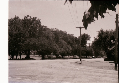
Yields information about the appearance of Wendouree Parade at the intersection with Webster St.Photograph of the intersection of the intersection of Webster St and Wendouree Parade, View Point with the milk bar on the right of the photo. Taken 28/2/1971.trams, tramways, wendouree parade, view point, webster st -
Glenelg Shire Council Cultural Collection
Negative - Glass Plate Negative, 1890-1910
Stereoscopic glass plate negative. Group of women in garden at 'Beechwood'.glass plate negative, beechwood, historic house, portland -
Moorabbin Air Museum
Plan - Drawings: 88732 (Proposed D/F Aerial, D/F Aerial Proposed Layouts, Aerials Arrangement, Aircraft Sealing, Cabinet Layout, Proposed Mounting, Proposed ‘Porters Installation), 89685 - Aerial Column Assembly, 89686 - Aerial Assembly, 89688 - Housing Top, 89689 - Housing Bottom, 89690 - Housing, 89691 - Screen, 89696 - Assembly Aerial Flange, 89699 - Flange, 8o702 - Stub Shaft, 89703 - Tube Inner, 89704 - Housing, 89705 - Bearing Upper, 89706 - Block Lamps, 89707 - Bracket, 89708 - Body, 89709 - Plate Illuminating, 89710 - Stop Plate, 89711 - Block Plug Mount, 89712 - Cap, 89713 - Scale, 89714 - Spacer, 89715 - Catch Pin, 89780 - Aerial Assembly, 89791 - Top Steady Anchorage Assembly, 90072 - Modifications Cessna, 90376 - Aerial Assembly Porter, 90391 - Modifications Porter, 90405 - Drilling Jig, o3031 - Experimental Auxiliary Aerial Project Thorough, Weapons Research Establishment
-
 Melbourne Tram Museum
Negative, Wal Jack collection, 1939
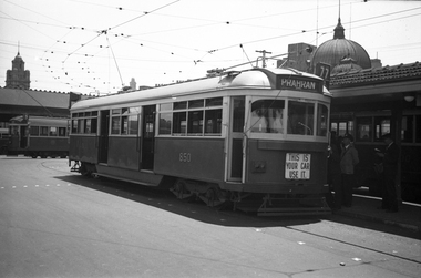
Black and white negative by Wal Jack of SW6 class 850 at the Princes Bridge terminus. The tram entered service 31/3/1939. Photo c1940. The microphone can be seen in the front window. Note no windscreen wiper. Tram running a route 77, Prahran. Has tail lights and dash canopy lighting with the sign "This is you car use it" underneath. The front number can just be seen. In Swanston St and adjacent are W2's. Other photos of the tram in the album are dated 1939, possibly late 1939 given it appears to a summer's day.trams, tramways, shelters, princes bridge, sw6 class, dash canopy lights, new tramcars, batman ave, tram 850 -
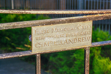 Eltham District Historical Society Inc
Negative - Photograph, Eltham War Memorial Gates, entrance to War Memorial buildings, 1998c
Gates donated by Cr. and Mrs Ernie J. Andrew. A check of the 1949 census shows Ernest James Andrew and Ellen Andrew living at Arthur Street. In 1937 they were both recorded in Main Road, Eltham, Ernie's occupation as newsagent. By 1943 they were recorded in Arthur Street and Ernie was retired. A search of our records shows that Ellen died 13 July 1946 and Ernie on 29 March 1950. Both are buried at Eltham Cemetery.Roll of 35mm colour negative film, 8 strips and associated 10 x 15 cm colour printKodak Gold 100-5ellen andrew, eltham war memorial, ernie andrew -
 Eltham District Historical Society Inc
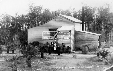
Negative - Photograph, Kinglake State School No. 2188, c.1915
Burnt down 1927. Reproduced on p75 of 'Pioneers & Painters'.This photo forms part of a collection of photographs gathered by the Shire of Eltham for their centenary project book,"Pioneers and Painters: 100 years of the Shire of Eltham" by Alan Marshall (1971). The collection of over 500 images is held in partnership between Eltham District Historical Society and Yarra Plenty Regional Library (Eltham Library) and is now formally known as the 'The Shire of Eltham Pioneers Photograph Collection.' It is significant in being the first community sourced collection representing the places and people of the Shire's first one hundred years.Digital image 4 x 5 inch B&W Negsepp, shire of eltham pioneers photograph collection, kinglake, kinglake state school no. 2188, pioneers and painters, school -
 Eltham District Historical Society Inc
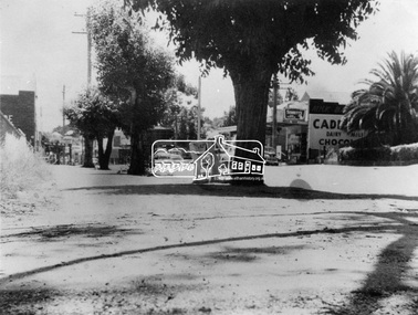
Negative - Photograph, Eltham - Main Road, 1950s
Source: Geo. W. Bell, Eltham This photo forms part of a collection of photographs gathered by the Shire of Eltham for their centenary project book,"Pioneers and Painters: 100 years of the Shire of Eltham" by Alan Marshall (1971). The collection of over 500 images is held in partnership between Eltham District Historical Society and Yarra Plenty Regional Library (Eltham Library) and is now formally known as the 'The Shire of Eltham Pioneers Photograph Collection.' It is significant in being the first community sourced collection representing the places and people of the Shire's first one hundred years.Digital image 4 x 5 inch B&W Negsepp, shire of eltham pioneers photograph collection, eltham, george w bell, main road -
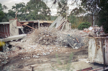
 Eltham District Historical Society Inc
Negative - Photograph, Harry Gilham, Shillinglaw trees from the safety compound: Demolition of Eltham Shire Offices, 895 Main Road, Eltham, Aug. 1996
The Shire Offices opened in 1965 and were extended in 1971. The final Eltham Shire Council meeting was held in December 1994 before the forced amalgamations of municipal councils by the Kennett Government. The State-Government-appointed Commissioners (1994-1996) took the decision in July 1996 to demolish the Eltham Shire Offices. The demolition works started within 24 hours of the decision being made.Roll of 35mm colour negative film, 5 of 6 strips Associated printKodak Gold 100-5eltham shire office, demolition, shillinglaw trees -
 Eltham District Historical Society Inc
Negative - Photograph, Harry Gilham, Demolition of Eltham Shire Offices, 895 Main Road, Eltham, Aug. 1996
The Shire Offices opened in 1965 and were extended in 1971. The final Eltham Shire Council meeting was held in December 1994 before the forced amalgamations of municipal councils by the Kennett Government. The State-Government-appointed Commissioners (1994-1996) took the decision in July 1996 to demolish the Eltham Shire Offices. The demolition works started within 24 hours of the decision being made.Roll of 35mm colour negative film, 5 of 6 strips Associated colour printKodak Gold 100-5eltham shire office, demolition -
 Kew Historical Society Inc
Plan - Subdivision Plan, Bonnie Doon Estate, c.1908
Pru Sanderson, in her groundbreaking ‘City of Kew Urban Conservation Study : Volume 2 - Development History’ (1988), summarised the periods of urban development and subdivisions of land in Kew. The periods that she identified included 1845-1880, 1880-1893, 1893-1921, 1921-1933, 1933-1943, and Post-War Development. These periods were selected as they represented periods of rapid growth or decline in urban development. An obvious starting point for Sanderson’s groupings involved population growth and the associated economic cycles. These cycles also highlighted urban expansion onto land that was predominantly rural, although in other cases it represented the decline and breakup of large estates. A number of the plans in the Kew Historical Society’s collection can also be found in other collections, such as those of the State Library of Victoria and the Boroondara Library Service. A number are however unique to the collection.The Kew Historical Society collection includes almost 100 subdivision plans pertaining to suburbs of the City of Melbourne. Most of these are of Kew, Kew East or Studley Park, although a smaller number are plans of Camberwell, Deepdene, Balwyn and Hawthorn. It is believed that the majority of the plans were gifted to the Society by persons connected with the real estate firm - J. R. Mathers and McMillan, 136 Cotham Road, Kew. The Plans in the collection are rarely in pristine form, being working plans on which the agent would write notes and record lots sold and the prices of these. The subdivision plans are historically significant examples of the growth of urban Melbourne from the beginning of the 20th Century up until the 1980s. A number of the plans are double-sided and often include a photograph on the reverse. A number of the latter are by noted photographers such as J.E. Barnes.The subdivision advertised as the Bonnie Doon Estate in Greensborough was first advertised in 1908. At that stage, the new subdivision included 15 allotments of between one and four acres. By the time the subdivision plan in the Kew Collection was created, only 12 lots of between ¾ and 2½ acres remained. Both the State Library and Kew plans emphasise the distance to the city being 13½ miles, which could be reached by train on weekdays and weekends. Unusually, the plan describes the suitability of lots as locations for ‘Week-end Homes’. Correspondingly, the train line is described as ‘The Holiday Resort for the Northern Suburbs’.bonnie doona estate, subdivision plans - greensborough -
 Eltham District Historical Society Inc
Negative - Photograph, J.A. McDonald, Heidelberg-Kinglake Road, Mar. 1960
Cherry Tree Road Job 56F443 Contractors Wolf and Wood Cutting pipes on 45-degree skew using cordlex Showing secondary cracking March 1960Record of various Shire of Eltham infrastructure works undertaken during the period of 1952-1962 involving bridge and road reconstruction projects, sometimes with Eltham Shire Council Project Reference numbers quoted. It was during this period that a number of significant improvements were made to roads and new bridges constructed within the shire that remain in place as of present day (2022). In many situations, the photos provide a tangible visible record of infrastructure that existed throughout the early days of the Shire. The album was put together by or under the direction of the Shire Engineer, J.A. McDonald.infrastructure, 1960-03, bridge construction, cherry tree road, heidelberg-kinglake road, road construction, shire of eltham -
University of Melbourne, Burnley Campus Archives
Plan, Plant Culture and Garden Maintenance Planting Plan Assignment, 1988
Tracing paper copy of plan of area with Tennis Court, to be removed. Signed MG?, July 1988.tennis court, burnley -
Moorabbin Air Museum
Plan (Item) - Mirage III C Drawing Fuselage Markings MIR III C 091 F1 ( In French)
-
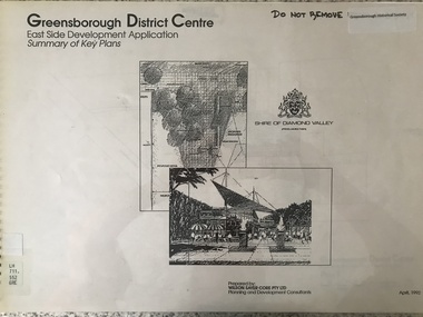 Greensborough Historical Society
Plan - Application, Wilson Sayer Core Pty Ltd, Greensborough District Centre: East side development application: summary of key plans. 1992, 1992_04
A summary of the plans for the Greensborough District Centre from 1992, with plans for the development of the East side of Main Street Greensborough.16 pages. Black and white line drawings and plans. Has plastic cover and wire binding. greensborough district centre, main street greensborough -
Port Melbourne Historical & Preservation Society
Plan - Cottage, c. 1865
IF Toll Gate Plan, refer Minute Book (Reg 234) September 1865 IF Poundkeeper's Cottage, see 7 December, 1865 referring to preparation of plan for house for Poundkeeper, (guesswork!)Front, side and section elevations and floor plan for unidentified cottage and gate, 1860s. Possibly tip tender.built environment - domestic -
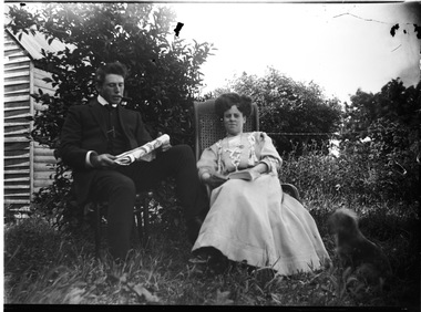 Wodonga & District Historical Society Inc
Negative - Haeusler Glass Negatives Collection - Man and woman seated in garden, c1910
The Wodonga Historical Society Haeusler Collection provides invaluable insight into life in late nineteenth and early twentieth century north east Victoria. The collection comprises manuscripts, personal artefacts used by the Haeusler family on their farm in Wodonga, and a set of glass negatives which offer a unique visual snapshot of the domestic and social lives of the Haeusler family and local Wodonga community. The Haeusler family migrated from Prussia (Germany) to South Australia in the 1840s and 1850s, before purchasing 100 acres of Crown Land made available under the Victorian Lands Act 1862 (also known as ‘Duffy’s Land Act’) in 1866 in what is now Wodonga West. The Haeusler family were one of several German families to migrate from South Australia to Wodonga in the 1860s. This digital image was produced from one of the glass negatives that form part of the collection, probably taken by Louis Haeusler (b.1887) with the photographic equipment in the Wodonga Historical Society Haeusler Collection.This item is unique and has well documented provenance and a known owner. It forms part of a significant and representative historical collection which reflects the local history of Wodonga. It contributes to our understanding of domestic and family life in early twentieth century Wodonga, as well as providing interpretative capacity for themes including local history and social history.Digital image created from the Haeusler Glass negative collection. An unidentified man and woman seated in a garden. He is smoking a pipe and reading the newspaper. A building is visible in to the left in the background. C. 1910wodonga pioneers, haeusler family, glass negatives, dry plate photography, wodonga families -
Moorabbin Air Museum
Plan (item) - Bristol Aeroplane 170 schematic drawings, Details of Lower Boom Assembly
Bristol Aeroplane Company Ltd -
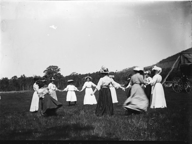 Wodonga & District Historical Society Inc
Negative - Haeusler Glass Negatives Collection - Picnic at Wodonga West, c1910
The Wodonga Historical Society Haeusler Collection provides invaluable insight into life in late nineteenth and early twentieth century north east Victoria. The collection comprises manuscripts, personal artefacts used by the Haeusler family on their farm in Wodonga, and a set of glass negatives which offer a unique visual snapshot of the domestic and social lives of the Haeusler family and local Wodonga community. The Haeusler family migrated from Prussia (Germany) to South Australia in the 1840s and 1850s, before purchasing 100 acres of Crown Land made available under the Victorian Lands Act 1862 (also known as ‘Duffy’s Land Act’) in 1866 in what is now Wodonga West. The Haeusler family were one of several German families to migrate from South Australia to Wodonga in the 1860s. This digital image was produced from one of the glass negatives that form part of the collection, probably taken by Louis Haeusler (b.1887) with the photographic equipment in the Wodonga Historical Society Haeusler Collection. This item is unique and has well documented provenance and a known owner. It forms part of a significant and representative historical collection which reflects the local history of Wodonga. It contributes to our understanding of domestic and family life in early twentieth century Wodonga, as well as providing interpretative capacity for themes including local history and social history.Digital image created from the Haeusler Glass negative collection. A group of women holding hands in a circle. All are wearing long dresses and hats. They were attending a picnic in Wodonga West, Victoria C. 1910wodonga pioneers, haeusler family, glass negatives, dry plate photography, women's clothing c. 1910, community activities