Showing 1653 items in the category Documentation with item type Plan
-
 Moorabbin Air Museum
Plan (item) - Bristol Aeroplane 170 schematic drawings, Assy of Prop Controls ( De Havilland )
Bristol Aeroplane Company Ltd -
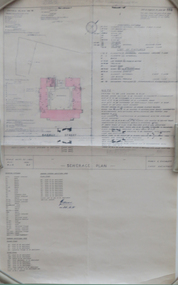
Ballarat Clarendon College
Plan, Proposed new school building Mair Street, Ballarat for the Committee of the Clarendon Presbyterian Ladies College, March 1925. P S Richards, Coburn and Richards, ARVIA Architects
Clarendon Presbyterian Ladies College moved from a property on the corner of Clarendon and Armstrong Streets, Soldiers Hill to new purpose built premises in Mair Street, Ballarat in 1926. Framed under glassclarendon presbyterian ladies college -
 Federation University Historical Collection
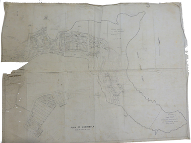
Plan, Plan of Merimbula, 1932, 1932
Printed plan on cottonmerimbula, south pacific ocean -
 Federation University Historical Collection
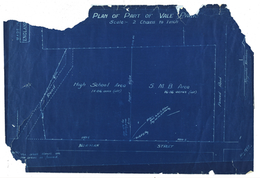
Plan, Plan of Part of Vale Park, 1928, 15/1928
Probably the Ballarat School of Mines Farm or pine plantation.Ballarat Techncial School Norman StreetBlue line plan of part of Vale Park, Ballarat. vale park, ballarat school of mines, ballarat school of mines farm, ballarat high school, norman street -
 Kew Historical Society Inc
Plan - Subdivision Plan, Corsewall Estate, 1938
The Kew Historical Society collection includes almost 100 subdivision plans pertaining to suburbs of the City of Melbourne. Most of these are of Kew, Kew East or Studley Park, although a smaller number are plans of Camberwell, Deepdene, Balwyn and Hawthorn. It is believed that the majority of the plans were gifted to the Society by persons connected with the real estate firm - J. R. Mathers and McMillan, 136 Cotham Road, Kew. The Plans in the collection are rarely in pristine form, being working plans on which the agent would write notes and record lots sold and the prices of these. The subdivision plans are historically significant examples of the growth of urban Melbourne from the beginning of the 20th Century up until the 1980s. A number of the plans are double-sided and often include a photograph on the reverse. A number of the latter are by noted photographers such as J.E. Barnes.The Corsewall Estate was a subdivision, bordering on Barkers Road and Auburn Road, which created Corsewall Close. This relatively late subdivision included 29 allotments. The subdivision plan includes the dimensions of each lot as well as the width of the existing and projected roads and turning circles. The Corsewall Close Precinct is now listed on the Victorian Heritage Database (HO147) and is noted for its ‘consistent flat-type development over the entire street, which has been cleverly designed to make multi-unit dwellings appear as single buildings’.subdivision plans - hawthorn, corsewall estate -- hawthorn (vic.) -
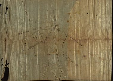
![Plan, Improvements on the Camp Reserve Ballarat, 1870, 26/4/1870 (exact); Traced by Henry [Mornes?], district surveyor, on the above date](/media/collectors/4f729f6797f83e0308601707/items/4f72a4fa97f83e0308602508/item-media/59b79d3921ea680200c6b8a7/item-fit-380x285.jpg) Federation University Historical Collection
Federation University Historical CollectionPlan, Improvements on the Camp Reserve Ballarat, 1870, 26/4/1870 (exact); Traced by Henry [Mornes?], district surveyor, on the above date
The Ballarat Camp housed the Goldfields administrators. It was from this site that the troopers left on the morning of 3 December 1854 to attack the Eureka Stockade. Much of the area shown in on the west side of Camp Street is now used by the Federation University Arts Academy.Hand-drawn plan on white linen showing the camp reserve in what is now known Ballarat's Camp Street. The plan shows allotments in an area bounded by Mair, Sturt and Lydiard Streets. The plan has colours indicating wooden buildings, stone buildings, brick buildings, Wood & zinc buildings, and wood & brick buildings.ballarat, camp street, horace walker, henry mornes, goldfields architecture, reserve for public, buildings, goldfields administration, eureka stockade -
 Kew Historical Society Inc
Plan - Subdivision Plan, Lodged Plan No.6518, 1920-1940
The Kew Historical Society collection includes almost 100 subdivision plans pertaining to suburbs of the City of Melbourne. Most of these are of Kew, Kew East or Studley Park, although a smaller number are plans of Camberwell, Deepdene, Balwyn and Hawthorn. It is believed that the majority of the plans were gifted to the Society by persons connected with the real estate firm - J. R. Mathers and McMillan, 136 Cotham Road, Kew. The Plans in the collection are rarely in pristine form, being working plans on which the agent would write notes and record lots sold and the prices of these. The subdivision plans are historically significant examples of the growth of urban Melbourne from the beginning of the 20th Century up until the 1980s. A number of the plans are double-sided and often include a photograph on the reverse. Reconciling this hand-drawn subdivision plan with a modern map of the area is initially a challenge due to a change of street names. Argyle Road in the centre of the subdivision was to be renamed Deepdene Road, and the street named Deepdene Road on the plan was to become Deepdene Place. Of interest is the nursery on the corner of Argyle and Whitehorse Roads. During this period there were a number of nurseries servicing the Kew and Balwyn areas. The subdivision was essentially of the land formerly occupied by the house 'Deepdene'.subdivision plans - balwyn, deepdene, whitehorse road -- deepdene (vic.), deepdene road -- deepdene (vic.), burke road -- deepdene (vic.) -
Bendigo Historical Society Inc.
Plan - SANDHURST BOYS CENTRE SITE PLANS: LISLE STREET UNITS
16 Working drawings including Floor Plans and Elevations Prepared by Michael DeVincentis, Architects; Wellington St Strathfieldsaye. October-November 1995. Scale 1:200. No 9538. Also Survey Plan for Lot 69D 3950 Sq m. Location unknown 16.02.2023.plan, bendigo, institutions, victoria. department of planning and development -
Glenelg Shire Council Cultural Collection
Plan - Plan - subdivision at Cape Bridgewater, 02/04/1992
Black and white photocopy of an old plan of a subdivision at Cape Bridgewater. In two halves, not joined together. Black texta numbers on some of the lots 1 - 28town planning, residential, cape bridgewater -
Port Melbourne Historical & Preservation Society
Plan - Possible maritime shed, Borough of Sandridge, 1870s
An identified building plan - presumably a maritime shed (front elevation faces "the river") - proving front, traverse and longitudinal sections. Possibly two buildings. Plan No. 3.Charles Clay B.S. [Borough Surveyor]:W. Weatherston[e]built environment - civic, piers and wharves, charles clay, william weatherston[e] -
University of Melbourne, Burnley Campus Archives
Plan, The Museum of Modern Art at Heide, 1995
(1) Photocopy of Herb and Plant Location Map, Heide Kitchen Garden, plants numbered, no legend. (2) 1 tracing paper, 1 paper and 1 paper reduced size, Sketch Plan. Scale 1:1000. Drawn by JK (Jill Kellow, Staff) 06.06.1995. (3) Photocopy of Heide Park and Art Gallery Grounds and Planting. Numbered Plant List, 1 Trees, 2 Shrubs.heide, museum of modern art, gardens, jill kellow, bulleen, kitchen garden -
 Kew Historical Society Inc
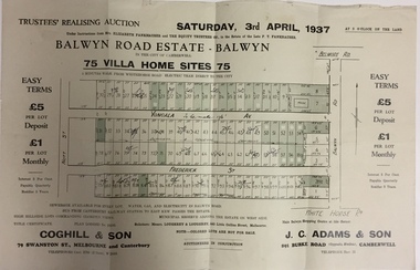
Plan - Subdivision Plan, Balwyn Road Estate, Balwyn (1937), 1937
Historic subdivision in Balwyn, VictoriaSubdivision Plan of Balwyn Road Estate (Balwyn). Held in April 1937, the auction included 102 lots for sale in Yongala Avenue, Young Street, and Balwyn RoadInscriptions on individual lots by agentsubdivision plans - balwyn (vic), balwyn road estate - balwyn -
 Bendigo Historical Society Inc.
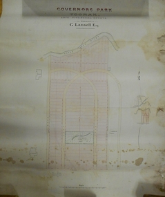
Plan - MARKS COLLECTION: PLAN OF G. LANSELL'S GOVERNOR'S PARK, TOORAK
Plan (tightly rolled) drawn on heavy paper mounted on fabric. On top of plan printed 'Governor's Park Toorak, late Vice-Regal Estate, the property of G. Lansell Esq' On top of plan Yarra River, on bottom Toorak Road, Plan shows subdivision, in centre of which is drawn outline of 8 acres containing the 'Mansion and Grounds'.bendigo, hospital -
 Federation University Historical Collection
Plan, Unidentified mine - underground workings
Plan showing underground drives. Ink on linen with green and brown shading. Red line.cgt, mining, plan, prospecting -
Port Melbourne Historical & Preservation Society
Plan - Proposed tramway for Williamstown Road, Port Melbourne, 5 May 1887
Detailed drawings of improved steel tramway broad plate system for ordinary road, proposed for Williamstown Road 1887local government - borough of port melbourne, engineering department - borough of port melbourne -
Moorabbin Air Museum
Plan (item) - Bristol Aeroplane 170 schematic drawings, Front Replacement Tube Complete
Bristol Aeroplane Company Ltd -
Port Melbourne Historical & Preservation Society
Plan, Graeme Bentley Pty Ltd, Port Melbourne Foreshore Landscape Master Plan MP4 (B), February 1993
The Port Melbourne Foreshore Landscape Master Plan was created by Landscape Architectural firm of Graeme Bentley Pty Ltd for the City of Port Melbourne. MP4 (B) portrays the section of foreshore Surrounding the Port Melbourne Lifesaving Club.The plan proposed street tree planting and lawn areas. The plan was not actioned.built environment - recreational facilities, beach street, port melbourne foreshore, port melbourne life saving club -
 Kew Historical Society Inc
Plan, Borough of Kew Detail Plan No.1577, 1904
The Melbourne and Metropolitan Board of Works (MMBW) plans were produced from the 1890s to the 1950s. They were crucial to the design and development of Melbourne's sewerage and drainage system. The plans, at a scale of 40 feet to 1 inch (1:480), provide a detailed historical record of Melbourne streetscapes and environmental features. Each plan covers one or two street blocks (roughly six streets), showing details of buildings, including garden layouts and ownership boundaries, and features such as laneways, drains, bridges, parks, municipal boundaries and other prominent landmarks as they existed at the time each plan was produced. (Source: State Library of Victoria)This plan forms part of a large group of MMBW plans and maps that was donated to the Society by the Mr Poulter, City Engineer of the City of Kew in 1989. Within this collection, thirty-five hand-coloured plans, backed with linen, are of statewide significance as they include annotations that provide details of construction materials used in buildings in the first decade of the 20th century as well as additional information about land ownership and usage. The copies in the Public Record Office Victoria and the State Library of Victoria are monochrome versions which do not denote building materials so that the maps in this collection are invaluable and unique tools for researchers and heritage consultants. A number of the plans are not held in the collection of the State Library of Victoria so they have the additional attribute of rarity.Original survey plan, issued by the MMBW to a contractor with responsibility for constructing sewers in the area identified on the plan within the Borough of Kew. The plan was at some stage hand-coloured, possibly by the contractor, but more likely by officers working in the Engineering Department of the Borough and later Town, then City of Kew. The hand-coloured sections of buildings on the plan were used to denote masonry or brick constructions (pink), weatherboard constructions (yellow), and public buildings (grey). MMBW Plan No.1577 includes some of the most significant houses in Kew: Herbert Henty’s ‘Roxeth’ (now part of Trinity Grammar), ‘Butleigh Wooton’, ‘Bokara’ and ‘Harrow’. It also includes the streets that have since changed their names. That part of College Parade linked to Glenferrie Road is now named College Place, College Parade now extends further north, and Charles Street did not yet reach Barkers Road. Roxeth is one of a number of Henty houses in Kew. Herbert Henty made his home here and was elected a member of Kew Municipal Council in 1864 and mayor in 1868-69. Walter Henry Serle, of Harrow served in the First World War. He was awarded the Military Medal ‘’For conspicuous bravery and devotion to duty. On 29th September near BELLICOURT he showed the greatest bravery and determination when his platoon was attacked by enemy bombing parties. It was due largely to his personal efforts that all the attacks were repulsed. Until wounded, his utter disregard of personal safety and boldness in dealing with the attacks were the means of saving the situation and were an inspiring example to his men.’melbourne and metropolitan board of works, detail plans, maps - borough of kew, mmbw 1577, cartography -
Port Melbourne Historical & Preservation Society
Plan, Graeme Bentley Pty Ltd, Port Melbourne Foreshore Landscape Master Plan MP1(A), February 1993
The Port Melbourne Foreshore Landscape Master Plan was created by Landscape Architectural firm of Graeme Bentley Pty Ltd for the City of Port Melbourne. MP1(A) portrays the section of foreshore from the former Port Melbourne Railway Station to Bay Street. The plan proposed extensive tree planting including Tasmanian native trees along Station Pier. The plan was not actioned.built environment - recreational facilities, beach street, port melbourne foreshore, station pier -
Port Melbourne Historical & Preservation Society
Plan - Woodruff Dairies, Bridge Street and Derham Street, Port Melbourne, Norman C Smith, Architects, 6 Oct 1950
From the Woodruff family archives, 4 photocopies 1950 plans for the Woodruff Dairies at Bridge St and Derham St.industry, business and traders - dairies, woodruff's superior dairies -
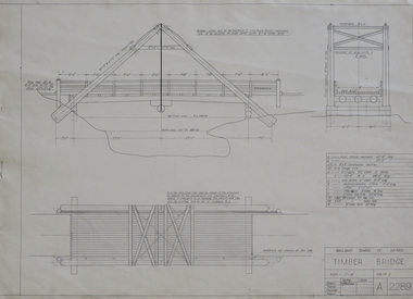 Federation University Historical Collection
Plan, Plan for a Timber Bridge
Plan for a timber bridgetimber bridge, j. calisto, geoff biddington -
Glenelg Shire Council Cultural Collection
Plan - Plans / Line Drawings - Port of Portland Slipway, Bilge Blocks Fishing Vessel Seamount Enterprise, Portland, Victoria, 08/11/1990
PORT OF PORTLAND AUTHORITY -
University of Melbourne, Burnley Campus Archives
Plan, Geoff Olive, Geoff Olive Notes, 16.05.2015
site plan, campus plan, geoff olive, history -
Port Melbourne Historical & Preservation Society
Plan - Toll bar, house and closet, Sandridge, Charles Clay?, Borough Surveyor, 1860s - 1870s
Plan and elevation for Borough of Sandridge toll bar, house and closet, hand drawn and coloured 1860s-70s. Master copy.Signed by Chas. Clay, Suveyor and John L. Forrester (?) and witnessed bt Thomas R. Warren (?).built environment - civic, charles clay, thomas peek warren, john l forrester -
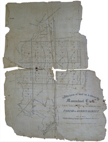 Federation University Historical Collection
Plan, Eugene Bellairs, Moorabool Creek, Parish of Kerrit-Bereet, 01/08/1855
Plan of the Moorabool Creek on the Melbourne Roadmoorabool, kerrit-bareet, moorabool creek, eugene bellairs -
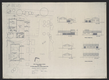 University of Melbourne, Burnley Campus Archives
Plan, Fooks Martin Sandow Pty. Ltd, Victorian College of Agriculture & Horticulture Burnley Campus New Workshop, Equipment Store, & Landscape Construction Facilities, 1996
Plans by Fooks Martin Sandow, August 1996. Scale 1:200. (1) New Mechanics Workshop, New Equipment Store, etc. and Landscape Construction, with Elevations. (2) Layout of Equipment Store - where each piece of equipment to be placed.vcah, fooks martin sandow, equipment store, landscape construction -
 Federation University Historical Collection
Plan, Sewerage Plan, 1950
Hand coloured sewerage plan: Barkly St plans, sewerage plans, percy everett -
Federation University Historical Collection
Plan, Ballarat East Longitudinal Section, not dated
Printed plan of Ballarat East showing pitch of quartz veins and crosscourses Sheet No 2plan, ballarat east, longitudinal section, mining -
University of Melbourne, Burnley Campus Archives
Plan - Photocopy, Sketch Plan, 1929
Photocopy of hand drawn plan of Section of Site indicating proposed irrigation. Probably from A.W. Jessep memos 1929."From Jessep memos(?) 1929irrigation, a.w. jessep, burnley gardens -
University of Melbourne, Burnley Campus Archives
Plan (collection), 1995
acm landscape architecture, annie mackinnon, burnley college, arboriculture and amenity building, landdscape design, centenary courtyardacm landscape architecture, annie mackinnon, burnley college, arboriculture and amenity building, landdscape design, centenary courtyard