Showing 1652 items in the category Documentation with item type Plan
-
 Kew Historical Society Inc
Plan - Subdivision Plan, Corsewall Estate, Hawthorn, 1938
The Kew Historical Society collection includes almost 100 subdivision plans pertaining to suburbs of the City of Melbourne. Most of these are of Kew, Kew East or Studley Park, although a smaller number are plans of Camberwell, Deepdene, Balwyn and Hawthorn. It is believed that the majority of the plans were gifted to the Society by persons connected with the real estate firm - J. R. Mathers and McMillan, 136 Cotham Road, Kew. The Plans in the collection are rarely in pristine form, being working plans on which the agent would write notes and record lots sold and the prices of these. The subdivision plans are historically significant examples of the growth of urban Melbourne from the beginning of the 20th Century up until the 1980s. A number of the plans are double-sided and often include a photograph on the reverse. A number of the latter are by noted photographers such as J.E. Barnes.This is a second, more complete version of the Corsewall Estate subdivision that is held by the Society. The Coreswall Estate was a subdivision, bordering on Barkers Road and Auburn Road, which created Corsewall Close. This relatively late subdivision included 29 allotments. The subdivision plan includes the dimensions of each lot as well as the width of the existing and projected roads and turning circles. The Corsewall Close Precinct is now listed on the Victorian Heritage Database (HO147) and is noted for its ‘consistent flat-type development over the entire street, which has been cleverly designed to make multi-unit dwellings appear as single buildings’. In this second version of the plan, the rarity of this late subdivision is emphasised by the auctioneers. The original plan must have contained a photograph, which is unfortunately truncated here.subdivision plans - hawthorn, corsewall estate -
 Port Melbourne Historical & Preservation Society
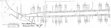
Plan - Victorian Railways 'single line diagram 'Princes Pier', Victorian Railways, Oct 1954
Diagrams created by the Victorian Railways with detailed information including weight of rails, distance of points/switches from the datum point, etc.Scanned copy of 'single line diagram' for 'Princes Pier'victorian railways, piers and wharves - princes pier -
 University of Melbourne, Burnley Campus Archives
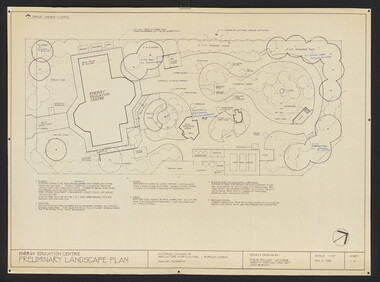
Plan, Steve Mullany, Energy Education Centre, 1988
(1) Tracing paper and paper plans, Preliminary Landscape Plan by Steve Mullany, Lecturer Amenity Horticulture Dept. V.C.A.H. Burnley, Sheet 1 of 1 May 2, 1988. (2) 1 tracing paper and 2 paper copies State Schools' Nursery: Proposed Landscape Working Drawing Energy Education Centre Burnley by E.A.H. June 1988. (3) 2 copies State Schools' Nursery: Proposed Landscape Working Drawing Energy Education Centre Burnley, by EAH 18 June 1988 (Details). (4) 2 copies as (3) Pond Plans & Details 16 June 1988. (5.) Designs for small plans of above.vcah, steve mullany, state schools nursery, landscape design, energy education centre burnley -
 Federation University Historical Collection
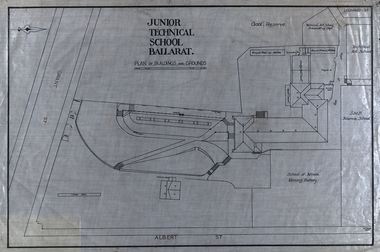
Plan, Plan of the Ballarat Junior Technical School Buildings and Grounds, 1923
The Ballarat Junior Technical School was a division of the Ballarat School of Mines. Plan of the Ballarat Junior Technical School, a division of the Ballarat School of Mines, The plan shows the Gaol Research, School of Mines Mining Battery, Common room, rifle range and cricket pitch. The school and grounds fronted Albert Street and Grant Street. gaol reserve, ballarat school of mines mining battery, model mine., mining battery, common room, rifle range, cricket pitch, albert street, grant street, ballarat school of mines, buildings, bicycle shed, ballarat technical art school, dressmaking, quoit court, architectural plans -
 University of Melbourne, Burnley Campus Archives
Plan, Burnley College Site, c. 1970 - 2001
Miscellaneous plans of the Burnley site with enlargements of sections. Roughly sorted. Different periods. Includes a map of Kew, and part of plan of Charman Ave., Emerald. Annotated plan of area of glass houses and chicken test pens ((1970 - 80?)burnley college, gardens, college buildings, kew, emerald -
![Monnington [Estate], 1935](/media/collectors/550653872162f11fb04854aa/items/5907eb86d0ce0c14e82385c8/item-media/5907ecafd0ce0c14e823e87f/item-fit-380x285.jpg) Kew Historical Society Inc
Kew Historical Society IncPlan - Subdivision Plan, Monnington [Estate], 1935, 1935
Pru Sanderson, in her groundbreaking ‘City of Kew Urban Conservation Study : Volume 2 - Development History’ (1988), summarised the periods of urban development and subdivisions of land in Kew. The periods that she identified included 1845-1880, 1880-1893, 1893-1921, 1921-1933, 1933-1943, and Post-War Development. These periods were selected as they represented periods of rapid growth or decline in urban development. An obvious starting point for Sanderson’s groupings involved population growth and the associated economic cycles. These cycles also highlighted urban expansion onto land that was predominantly rural, although in other cases it represented the decline and breakup of large estates. A number of the plans in the Kew Historical Society’s collection can also be found in other collections, such as those of the State Library of Victoria and the Boroondara Library Service. A number are however unique to the collection.Subdivision plans are historically important documents used as evidence of the growth of suburbs in Australia. They frequently provide information about when the land was sold on which a built structure was subsequently constructed as well as evidence relating to surveyors and real estate and financial agents. The numerous subdivision plans in the Kew Historical Society's collection represent working documents, ranging from the initial sketches made in planning a subdivision to printed plans on which auctioneers or agents listed the prices for which individual lots were sold. In a number of cases, the reverse of a subdivision plan in the collection includes a photograph of a house that was also for sale by the agent. These photographs provide significant heritage information relating house design and decoration, fencing and household gardens.The first subdivision of Monnington took place in 1935. At that time, Monnington and 10 new allotments were offered for sale bordering Adeney and Marshall Avenues. In this subdivision plan, Monnington is one of 13 lots for sale. The subdivision created the irregular land holding of Monnington today. The excision of southwest corner of Monninton was caused by the need to have regular allotments facing the curve in Marshall Avenue.monnington - adeney avenue -- kew (vic.), subdivision plans -- kew (vic.) -
 University of Melbourne, Burnley Campus Archives
Plan, VCAH -Burnley: Sluice Valve, Tap & Fire Hydrant Locations, c. 1987
Plan showing locations and instructions for use, hand drawn. "Overlay onto SP1 Plan 1/1987," handwritten on it. Plan same as 11.0715.vcah, sluice valves, taps, fire hydrants -
Glen Eira Historical Society
Plan - Bambra Road, 271, Caulfield South
A hand-drawn plan (203mm x 297mm), most likely of 271 Bambra Road, Caulfield South. Also included are handwritten notes, likely dated 6/08/1953, calculating increase of rent and listing tenant as Mrs Griffiths (Legacy Widow).griffiths mrs, bambra road, caulfield south, rents, legacy, widows, houses -
 Kew Historical Society Inc
Plan, Borough of Kew Detail Plan No.1577, 1904
The Melbourne and Metropolitan Board of Works (MMBW) plans were produced from the 1890s to the 1950s. They were crucial to the design and development of Melbourne's sewerage and drainage system. The plans, at a scale of 40 feet to 1 inch (1:480), provide a detailed historical record of Melbourne streetscapes and environmental features. Each plan covers one or two street blocks (roughly six streets), showing details of buildings, including garden layouts and ownership boundaries, and features such as laneways, drains, bridges, parks, municipal boundaries and other prominent landmarks as they existed at the time each plan was produced. (Source: State Library of Victoria)This plan forms part of a large group of MMBW plans and maps that was donated to the Society by the Mr Poulter, City Engineer of the City of Kew in 1989. Within this collection, thirty-five hand-coloured plans, backed with linen, are of statewide significance as they include annotations that provide details of construction materials used in buildings in the first decade of the 20th century as well as additional information about land ownership and usage. The copies in the Public Record Office Victoria and the State Library of Victoria are monochrome versions which do not denote building materials so that the maps in this collection are invaluable and unique tools for researchers and heritage consultants. A number of the plans are not held in the collection of the State Library of Victoria so they have the additional attribute of rarity.Original survey plan, issued by the MMBW to a contractor with responsibility for constructing sewers in the area identified on the plan within the Borough of Kew. The plan was at some stage hand-coloured, possibly by the contractor, but more likely by officers working in the Engineering Department of the Borough and later Town, then City of Kew. The hand-coloured sections of buildings on the plan were used to denote masonry or brick constructions (pink), weatherboard constructions (yellow), and public buildings (grey). MMBW Plan No.1577 includes some of the most significant houses in Kew: Herbert Henty’s ‘Roxeth’ (now part of Trinity Grammar), ‘Butleigh Wooton’, ‘Bokara’ and ‘Harrow’. It also includes the streets that have since changed their names. That part of College Parade linked to Glenferrie Road is now named College Place, College Parade now extends further north, and Charles Street did not yet reach Barkers Road. Roxeth is one of a number of Henty houses in Kew. Herbert Henty made his home here and was elected a member of Kew Municipal Council in 1864 and mayor in 1868-69. Walter Henry Serle, of Harrow served in the First World War. He was awarded the Military Medal ‘’For conspicuous bravery and devotion to duty. On 29th September near BELLICOURT he showed the greatest bravery and determination when his platoon was attacked by enemy bombing parties. It was due largely to his personal efforts that all the attacks were repulsed. Until wounded, his utter disregard of personal safety and boldness in dealing with the attacks were the means of saving the situation and were an inspiring example to his men.’melbourne and metropolitan board of works, detail plans, maps - borough of kew, mmbw 1577, cartography -
Moorabbin Air Museum
Plan (item) - C.A.C Power/Condensing Unit Test Support Frame
-
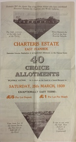 Kew Historical Society Inc
Plan - Subdivision Plan, Charteris Estate, East Ivanhoe, 1939
The Charteris Estate in Ivanhoe was sold in a number of sections. Copies of a subdivision plan of the first section is in the State Library of Victoria collection. This later section of the Charteris Estate includes lots in the Government Boulevard, Castella Street, McArthur Road, Burke Road North, Charteris Drive and Warncliff Road.Subdivision plans like that for the Charteris Estate are invaluable records for local historians identifying when lots in streets were promoted for sale.Four-fold brochure advertising the Charteris Estate in East Ivanhoe in 1939. Streets named on the plan include: the Government Boulevard, Castella Street, McArthur Road, Burke Road North, Charteris Drive and Warncliff Road. The brochure contains photos of Charterisville, the home of F De Castella Esq and also of attractive rolling hills. Annotations in pencilcharteris estate - east ivanhoe (vic), subdivision plans - east ivanhoe (vic) -
Kew Historical Society Inc
Plan - Camberwell Panorama Estate, 1923
Subdivision plans and real estate flyers/brochures reveal a number of aspects of urban development and history. The Kew Historical Society's collection of these plans, as well as advertisements extracted from magazines, cover key aspects of community development and architectural history of Kew and Kew Eat as well as surrounding suburbs. While most of the plans in the collection were gifted to the Society by the former City of Kew, a number of other plans and advertisements have been donated by individuals, of which this is an example.Promotional brochure for the Camberwell Panorama Estate. The four page bifold handout advertises 216 home sites bounded by Bulleen Road, The Nook, Fortuna Avenue, and Doncaster Road. Other streets in the subdivision include: Sunburst Avenue, The Moor, and Macedon Avenue. The brochure has been damaged at some time in the past and so masking tape obscures the tram on page 1. Page 2 includes the plan of the subdivision, page 3 information about the site and a locality plan, while page 4 includes photographs and terms of sale. subdivision plans -- balwyn north (vic.), camberwell panorama estate -
Moorabbin Air Museum
Plan (item) - Plate - Modification And Serial SD 231
-
Moorabbin Air Museum
Plan (item) - CAC Collection - Bell Helicopter Production Plan For 206-B1 Civil A/C 206-B1 Australian Military A/C Bulletin PR2
-
 Vision Australia
Plan - Image, Conversion to Administrative offices / Conversion to Rehabilitation centre, 1 November 1962 - 5 April 1963
Over 1962-63, plans were drawn up for the conversion of the main building into administrative offices and a rehabilitation centre. As the children were now located at the school in Burwood, and with funds achieved from the sale of the old factory buildings to the Alfred Hospital, the St Kilda Road building could expand room for its office workers and provide greater floor space to rehabilitation staff. These plans show the proposed conversion from bedrooms to administrative and rehabilitation areas.7 architectural plans and 1 letterJohn F D Scarborough and Partners, Architectsroyal victorian institute for the blind, plans -
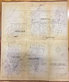 Kew Historical Society Inc
Plan, City Engineers Department (Heidelberg), City of Heidelberg Plan: Scale 20 chns to 1 inch, 1970-1993
Gwen Barton McWilliam (nee: Nelson), OAM, BA (1933- ). Gwen McWilliam is well known as an authority on the history of Boroondara and the author of a large number of books and pamphlets about the City. She was awarded the medal of the Order of Australia in 2001 ‘for service to the community of Hawthorn and district, particularly through the research, documentation and publication of its history.’ Primary source annotated by a distinguished local historian.Plan of number of areas in the City of Heidelberg showing municipal and ward boundaries, subsequently annotated by the historian Gwen McWilliam, identifying significant landholdings, subdivisions and key dates.The base map was printed in 1970 and annotated c.1993. The plan was donated to the Kew Historical Society by Gwen McWilliam. Handwritten annotations by Gwen McWilliam, 1993city of heidelberg, maps -- heidelberg (vic.), gwen mcwilliam -
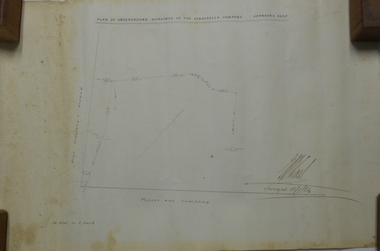 Bendigo Historical Society Inc.
Plan - MARKS COLLECTION: PLAN OF UNDERGROUND WORKINGS CINDERELLA COMPANY, JOHNSON'S REEF
Plan on heavy parchment paper: on top of plan 'Plan of the underground workings Cinderella Company, Johnson's Reef' Lh side of plan 'Kent Company's Ground' on bottom: Tipper and Company. Written on bottom surveyed 13/7/64.bendigo, mining, cinderella company -
Port Melbourne Historical & Preservation Society
Plan - Concept, Boulevard upgrade at Sandridge Beach, existing conditions, 2003
Plans. Existing conditions. Concept for the Boulevard upgrade at Sandridge Beach. Dated October 2003local government - city of port melbourne, engineering - roads streets lanes and footpaths -
University of Melbourne, Burnley Campus Archives
Plan, Garden Advisory Centre Summer House. Landscape working drawing 1:50, 1985
Copy of Landscape Working Drawing for the Agriculture Research Institute by the Public Works Department, Victoria No 85-523 L1/1 dated 30.01.1985. Scale 1:50.garden advisory centre, summer house, agriculture research institute, victoria public works department, landscape drawing, burnley gardens -
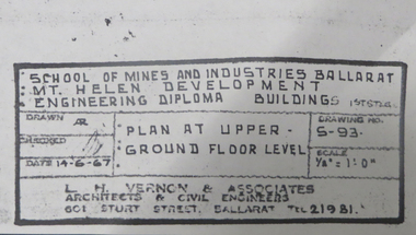 Federation University Historical Collection
Plan, Mt Helen Engineering Diploma Buildings, 1967, 14/06/1967
Copies of plans for Mount Helen E Building. mt helen campus, engineering building, mt helen e building, metallurgy, engineering, l.h. vernon and associates, architectural drawings -
 Kew Historical Society Inc
Plan - Subdivision Plan, Riversdale Estate, 1939
The Kew Historical Society collection includes almost 100 subdivision plans pertaining to suburbs of the City of Melbourne. Most of these are of Kew, Kew East or Studley Park, although a smaller number are plans of Camberwell, Deepdene, Balwyn and Hawthorn. It is believed that the majority of the plans were gifted to the Society by persons connected with the real estate firm - J. R. Mathers and McMillan, 136 Cotham Road, Kew. The Plans in the collection are rarely in pristine form, being working plans on which the agent would write notes and record lots sold and the prices of these. The subdivision plans are historically significant examples of the growth of urban Melbourne from the beginning of the 20th Century up until the 1980s. A number of the plans are double-sided and often include a photograph on the reverse. A number of the latter are by noted photographers such as J.E. Barnes.The Riversdale Estate in Hawthorn created a subdivision of 20 allotments bordering on Riversdale Road and Riversdale Court (which was created by the subdivision). The Locality Plan at right lists the major public buildings in the area: Burnely Horticultural Gardens, Hawthorn Tram Depot and Railway Station, Scotch College and the River Yarra and The Boulevard.subdivision plans - hawthorn, riversdale estate -
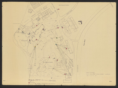
University of Melbourne, Burnley Campus Archives
Plan, University of Melbourne Burnley Campus Arboretum Development Stage 1, 2005
8 tracing paper and paper sketches by JK dated 25.07.2005. arboretum, plants -
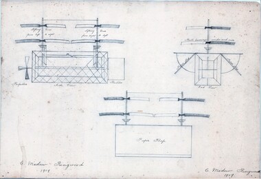 Ringwood and District Historical Society
Plan - Model Helicopter, Charles Medew, Ringwood, Victoria - 1909
(Source: The First One Hundred Years by R.S. Medew and I.M. Bowman - A History of The Medew Family in Victoria - page 11 extracts) - Charles Turner Medew (1829-1915 ) arrived in Victoria from England in 1857. He eventually settled in Ringwood as the original purchaser of Crown Allotment 32, Section C, where he built his own home in 1888 and became well known locally "for his fine building work and stone masonry." ... "In his retirement, Charles Medew experimented with model helicopters. About 1910, at the age of 80 years, he was able to raise these helicopters to such a point of efficiency that, just with an elastic wound propeller, when released they could fly upwards to the height of the large oak trees." ... "(Also) In 1910, Charles obtained plans and made a model of the Wright Brothers' biplane entirely of wood, with laminated wood propeller and driven by twisted elastic bands." This model remained in his workshop for many years after his death and with his family's permission was eventually placed in the Melbourne Science Museum.3 pencil drawings showing assembled parts and sectional views of a model helicopter. -
Moorabbin Air Museum
Plan (item) - C.A.C Valve Assy. - Hyd.Alighting Gear & Fair.Door Selector ( Complete) 27-58678
-
Moorabbin Air Museum
Plan (Item) - Drawing Exterior Emergency Marking - Lower Surface & STBD Side Orion P3-B Aircraft ,Drawing No. A16194, Sheet 3 Of 5 Sheets
-
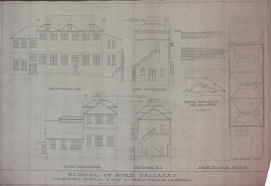 Federation University Historical Collection
Plan, Ballarat School of Mines Old Chemistry Building Plans, 1953, 02/09/1953
Short tears at righ hand endge and lower righ hand edge. Pink chemical discolouratoin on righ hand edge. Alteration plans showing llevations and sections of the Ballarat School of Mines Old Chemistry Buildings.ballarat school of mines, old chemistry building, plans, buildings, architectural plans -
 Kew Historical Society Inc
Plan - Subdivision Plan, Cotham Vale Estate, 1919
Pru Sanderson, in her groundbreaking ‘City of Kew Urban Conservation Study : Volume 2 - Development History’ (1988), summarised the periods of urban development and subdivisions of land in Kew. The periods that she identified included 1845-1880, 1880-1893, 1893-1921, 1921-1933, 1933-1943, and Post-War Development. These periods were selected as they represented periods of rapid growth or decline in urban development. An obvious starting point for Sanderson’s groupings involved population growth and the associated economic cycles. These cycles also highlighted urban expansion onto land that was predominantly rural, although in other cases it represented the decline and breakup of large estates. A number of the plans in the Kew Historical Society’s collection can also be found in other collections, such as those of the State Library of Victoria and the Boroondara Library Service. A number are however unique to the collection.The Kew Historical Society collection includes almost 100 subdivision plans pertaining to suburbs of the City of Melbourne. Most of these are of Kew, Kew East or Studley Park, although a smaller number are plans of Camberwell, Deepdene, Balwyn and Hawthorn. It is believed that the majority of the plans were gifted to the Society by persons connected with the real estate firm - J. R. Mathers and McMillan, 136 Cotham Road, Kew. The Plans in the collection are rarely in pristine form, being working plans on which the agent would write notes and record lots sold and the prices of these. The subdivision plans are historically significant examples of the growth of urban Melbourne from the beginning of the 20th Century up until the 1980s. A number of the plans are double-sided and often include a photograph on the reverse. A number of the latter are by noted photographers such as J.E. Barnes.The Cotham Vale Estate was a subdivision of land between Alfred, Thomas, Rowland and John Streets. It was promoted in the same time as the nearby Normanby Heights Estate. Cotham Vale included 28 allotments. Contemporary newspaper advertisements noted that the Estate ‘is most conveniently situated in a well elevated position, only 2 minutes from Cotham rd. Electric Cars, penny section to Kew station’.subdivision plans - kew, cotham vale estate, rowland street -- kew (vic.), thomas street -- kew (vic.), john street -- kew (vic.) -
 Federation University Historical Collection
Plan, Shewing the workings of the Kuboid Quartz Gold Mining Company, Sulky Gully, not dated
Hand drawn plan with red and blue shading showing the workings of the Kuboid Quartz Gold Mining Cokuboid quartz gold mining company, gold mining, sulky gully -
Port Melbourne Historical & Preservation Society
Plan - Montague Housing Development
COPYRIGHT PUBLIC RECORDS OFFICE Set of plans and documents relating to the State Savings bank, Montague Housing Development, in Gladstone St, Montague. This was an initiative of South Melbourne City Council to replace slum housing in Montague, 1935-40 .02 - 41 A4 pages including index, copies (some laminated)built environment - domestic, state savings bank of victoria -
Moorabbin Air Museum
Plan (item) - Vickers Viking Civil Transport Hercules Engines Drawing Drg 45381 Sheet 1 Issue B Sheet 2 Issue B Sheet 3 Issue B F.L.R. June 1946 P.B. January 1947
vickers-armstrong viking civil transport aircraft