Showing 1648 items in the category Documentation with item type Plan
-
 Moorabbin Air Museum
Plan (item) - Bristol Aeroplane 170 schematic drawings, Bonding Procedure
Bristol Aeroplane Company Ltd -
University of Melbourne, Burnley Campus Archives
Plan, C. van Zwel, A Blind Lady's Dream - Site Analysis, 1983
Proposed garden for Mrs C van Zwol of 99 St Clem's Road East Doncaster 3109. Microclimates, Influences and Services by Jacinta Bartlet.t Drawing No 3/8 dated October 1983. Includes 7 colour photographs.jacinta bartlett, east doncaster, microclimates -
Clunes Museum
Plan - PLANS, YUNCKEN, FREEMAN & FREEMAN, CLUNES PUBLIC HOSPITAL ALTERNATIONS & ADDITIONS, 1935
SHEET OF PAPER, HAND DRAWN PLANS IN BLACK INK, INCLUDES ELEVATION VIEWSWRITTEN IN PENCIL ON REVERSE "PLANS RECONSTRUCTION CLUNES HOSPITAL (COPY) 1935clunes public hospital, yuncken, freeman -
 Federation University Historical Collection
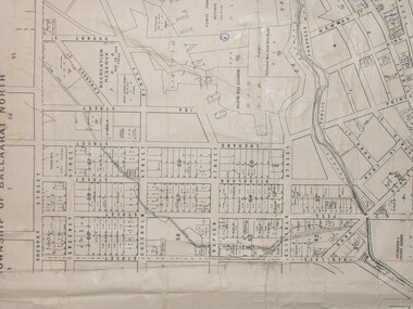
Plan, City of Ballarat (Part) (Ballaarat East), 08/05/1928
Crown Cadastral Plan showing Governement Roads, Crown Parcels, Dimensions, Crown grantees, dated of grants, etc in Ballarat East. The plan shows features such as Bakery Hill, Canadian Station, recreation reserves, timber reserves, Yarrowee Creek, Black Hill Reserve, Eureka Reserve and Garden, Orphan Asylum, Rifle Butts Reserve, Ballarat Woollen Mill, Ballarat Observatory, Sovereign Hill Recreation Reserve, Specimen Vale, Market Reserve, Cemetery WGS 84 Centroid 37 degrees 33' 55" S 143 degrees 52' 38" E E.W. Extent; 5 km N-S Extent; 4 kmmap, plan, ballarat east, ballarat woollen mill, ballarat railway line, ballarat railway station, eureka reserve, eureka cemetery, ballarat orphanage, russell square, bakery hill -
 Friends of Ballarat Botanical Gardens History Group
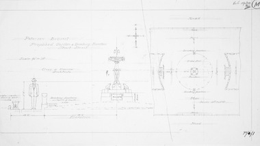
Plan - Design for Petersen Bequest, Proposed Garden and Drinking Fountain Sturt Street Ballarat
Photocopy of pencil design on paperpetersen bequest, garden drinking fountain, sturt street ballarat -
 Kew Historical Society Inc
Plan - Subdivision Plan, Jaques Estate, 1927
The Kew Historical Society collection includes almost 100 subdivision plans pertaining to suburbs of the City of Melbourne. Most of these are of Kew, Kew East or Studley Park, although a smaller number are plans of Camberwell, Deepdene, Balwyn and Hawthorn. It is believed that the majority of the plans were gifted to the Society by persons connected with the real estate firm - J. R. Mathers and McMillan, 136 Cotham Road, Kew. The Plans in the collection are rarely in pristine form, being working plans on which the agent would write notes and record lots sold and the prices of these. The subdivision plans are historically significant examples of the growth of urban Melbourne from the beginning of the 20th Century up until the 1980s. A number of the plans are double-sided and often include a photograph on the reverse. A number of the latter are by noted photographers such as J.E. Barnes.The Jaques Estate was a small subdivision of eight residential allotments bordering Jaques Street and Barkers Road in what is now Hawthorn East. Advertised in The Argus as being in ‘Upper Hawthorn’ the subdivision was claimed to include: ‘charming villa sites in excellent situations, with every convenience available, and with superior homes surrounding’.subdivision plans - hawthorn, jaques estate -
 University of Melbourne, Burnley Campus Archives
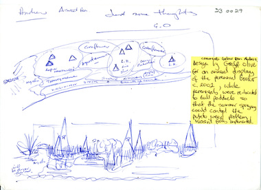
Plan, Perennial Border
perennial border, geoff olive, andrew smith, potato weed -
University of Melbourne, Burnley Campus Archives
Plan, Base Plan Front Garden Maughan Parade, c. 1980
1. Tracing paper and paper copies, Site Plan. Scale 1:100. Drawn by JK. 2. Site plan Scale 1:200 (plan of whole site)maughan parade, gardens -
Port Melbourne Historical & Preservation Society
Plan - CD-ROM, "State Bank of Victoria - Proposed dwelling Fishermans Bend"
Plans were brought to us by CBA employee Steve Tserkezidis CD with items below. From series of State Bankhouse plans and elevations of types 1 - 8. A1 copies (.01) 1937 (stamp). (.02) 1928. (.03) 1937. (.04) 1937. (.05) no date. (.06) 1928. (.07) 1937. (.08) 1938. From plans accompanying bank House plans .01 to .08; (.09) MMBW plan showing bank properties (.10) Bank house plan: sections through walls. (.11) "Fishermans bend group" plan of properties (.12) Bank House plan of Pier Foundationgarden city, built environment - domestic, state savings bank of victoria, bank houses -
 Bendigo Historical Society Inc.
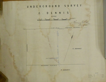
Plan - MARKS COLLECTION: PLAN OF UNDERGROUND SURVEY G. DENNIS MINE
Plan drawn on heavy parchment 'underground survey G. Dennis' printed on top of plan. Plan shows boundary lines and peg site. P. Bonati claim marked on bottom of plan. B. Letter with plan on letterhead 'City of Sandhurst, Town Hall, July 2nd. 1873' Addressed to Mr. George Dennis, Sir, In reply to your letter of the 19th. ulto I am empowered to state that subject to the formation of the road referred to, your existing rights are conserved, and the council will undertake not to object to the renewal of your lease. The only conditions being that you shall not sink a shaft in the street or attempt to obstruct it when formed. I have the honor to be, Sir, your obedient servant, Geo Fletcher, Town Clerk.bendigo, mining, g. dennis claim -
University of Melbourne, Burnley Campus Archives
Plan - Photocopy, Additions to Curator's Residence Royal Horticultural Gardens Burnley 1899, 1899
Photocopy. Additions to Curator's Residence, Royal Horticultural Gardens, Burnley. Elevations and Ground and Roof Plan. Drawing No 1 Stamped GB 5169. Dated 6.6.99. From Public Records Office.burnley gardens, curator's residence -
 Kew Historical Society Inc
Plan, Melbourne & Metropolitan Board of Works : Borough of Kew : Detail Plan No.1592, 1905
The Melbourne and Metropolitan Board of Works (MMBW) plans were produced from the 1890s to the 1950s. They were crucial to the design and development of Melbourne's sewerage and drainage system. The plans, at a scale of 40 feet to 1 inch (1:480), provide a detailed historical record of Melbourne streetscapes and environmental features. Each plan covers one or two street blocks (roughly six streets), showing details of buildings, including garden layouts and ownership boundaries, and features such as laneways, drains, bridges, parks, municipal boundaries and other prominent landmarks as they existed at the time each plan was produced. (Source: State Library of Victoria). This plan forms part of a large group of MMBW plans and maps that was donated to the Society by the Mr Poulter, City Engineer of the City of Kew in 1989. Within this collection, thirty-five hand-coloured plans, backed with linen, are of statewide significance as they include annotations that provide details of construction materials used in buildings in the first decade of the 20th century as well as additional information about land ownership and usage. The copies in the Public Record Office Victoria and the State Library of Victoria are monochrome versions which do not denote building materials so that the maps in this collection are invaluable and unique tools for researchers and heritage consultants. A number of the plans are not held in the collection of the State Library of Victoria so they have the additional attribute of rarity.Original survey plan, issued by the MMBW to a contractor with responsibility for constructing sewers in the area identified on the plan within the Borough of Kew. The plan was at some stage hand-coloured, possibly by the contractor, but more likely by officers working in the Engineering Department of the Borough and later Town, then City of Kew. The hand-coloured sections of buildings on the plan were used to denote masonry or brick constructions (pink), weatherboard constructions (yellow), and public buildings (grey). In MMBW Plan No.1592, the pink line indicates that area of the plan for which the contracting engineer was responsible. Included in the Plan are a number of primarily brick villas in a section of Belmont Avenue off Cotham Road. The house ‘Uvadale’ north of Belmont Avenue, and facing Cotham Road is also included in the contract. Excluded from the contract but shown on the Plan are ‘Glendonald’, ‘Mont Belmont’ and ‘Gilden’.melbourne and metropolitan board of works, detail plans, survey plans - borough of kew, mmbw 1592, cartography -
Glenelg Shire Council Cultural Collection
Plan - Plans / Line Drawing Port of Portland Slipway Twin Screw Tug 'Kalimni', 16/03/1981
Front: '14' - black texta, top right cornerport of portland -
 Federation University Historical Collection
Plan - Engineering drawings, 'Coal Stage for Locomotive', 1975, 1972
William Gerard Griffiths was a student at the Ballarat Institute of Education when he completed this drawing.Pencil on paper student's technical drawing 'Coal stage for locomotive' civil engineering, technical drawing, w. g.griffiths, ballarat institute of advanced education, alumni, railway -
Moorabbin Air Museum
Plan (item) - Bristol Aeroplane 170 schematic drawings, Skin Reinforcing Plate
Bristol Aeroplane Company -
Moorabbin Air Museum
Plan (item) - Bristol Aeroplane 170 schematic drawings, Front Replacement Tube Complete
Bristol Aeroplane Company Ltd -
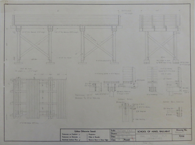
 Federation University Historical Collection
Plan, Ballarat School of Mines Plumbing Building additions, 1948, 1948
Copy of plans showing elevations for additions to the Ballarat School of Mines Plumbing Shopballarat school of mines, plumbing, architectural plan -
Moorabbin Air Museum
Plan (item) - C.A.C Fighter Scale : 1/24th XP.67
-
Glenelg Shire Council Cultural Collection
Plan - Ship Plan / Mould, n.d
Wooden pattern for mould for boat fittings. Similar to 6418. -
Vision Australia
Plan - Image, Vision Australia Kensington plans, 2009
Diagrams of seating and layout for the opening of Vision Australia's office in Macaulay Road, Kensington in 2009.Digital files of Macaulay office fit outvision australia, plans -
Port Melbourne Historical & Preservation Society
Plan - North west elevation, Port Melbourne Town Hall, Engineering Department, City of Port Melbourne, 1915
Plan of new (1915) Town Hall, Port Melbourne (proposal ?). North west elevation, longitudinal section, front elevation, cross section A-A, section B-B.port melbourne town hall -
Clunes Museum
Plan - CLUNES TOWN HALL AND COURTHOUSE, 30TH JULY 1892
MADE BY HARRY E SANDO CE; TOWN CLERK & ENGINEER, BOROUGH OF CLUNES, 30TH JULY 1892ACTUAL PLAN OF THE CLUNES TOWN HALL AND COURTHOUSE 1892 DRAWING DONE BY HARRY SANDS, TOWN CLERK AND ENGINEERlocal history, document, plans, town hall -
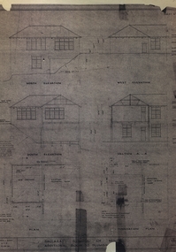
Clunes Museum
Plan - Building Plans, Proposed Layout Plan Clunes Neighborhood House, 12 June 2009
Architectural plan of proposed Clunes Neighborhood House Free Lending Library Development.A1 size architectural plan of proposed Clunes Neighborhood House Free Lending Library Development. Includes floor plan, front and side elevations. Dated 12 June 2009 by Kevyn Joy Architects.clunes neighbourhood house, kevyn joy architects, building plans -
Moorabbin Air Museum
Plan (item) - Bristol Aeroplane 170 schematic drawings, Unable to determine due to condition of document
Bristol Aeroplane Company Ltd -
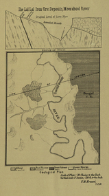 Federation University Historical Collection
Plan, Lal Lal Iron Ore Deposits, Moorabool River, 1881
This plan was printed in the Ballarat School of Mines Annual Report were Ferdinand Krause was a professor.Printed plan showing iron ore deposits at Lal Lal.lal lal ore, moorabool river, ferdinand krause -
Port Melbourne Historical & Preservation Society
Plan - Annotated and handcoloured by Peter Libbis to indicate his research into Libbis family residences and hotels on copy of a section of an MMBW map, Melbourne and Metropolitan Board of Works, c. 1980s
Peter LIBBIS obtained these copies from the MMBW when he researched his family history in the 1980s. He has annotated them, colour in hotels etc. Donated to Society in 1997.One of a group of 19 photocopies of various 20th century MMBW plans, annotated/coloured in to indicate residences of Libbis family and local hotels, by Peter LIBBIS in family and hotel research - Princes, Graham to Liardet (portion thereof; i.e. of 671.18)business and traders - hotels, built environment - domestic, transport - railways, melbourne and metropolitan board of works, libbis family, thomas libbis -
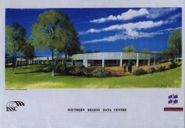 Federation University Historical Collection
Plan, Southern Region Data Centre Picture
The Southern Region Data Centre is part of the University of Ballarat which is a predecessor of Federation UniversityLaminated A4 size picture of ISSC Southern Region Data Centreissc, southern region data centre, university of ballarat, demaine partnership pty ltd -
Glenelg Shire Council Cultural Collection
Plan - Plan - Country Roads Board Specifications, n.d
Port of Portland Authority Archivesport of portland archives -
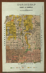 Federation University Historical Collection
Plan - Parish Plan, Corindhap, County of Grenville, 1898
Colour Parish Plan of Corindhap, County of Grenville, and a report on the Parish.corindhap, dereel, warrambine, kuracaruc, commeralghip, rokewood, kuruc-a-ruc, w. elder, william elder, john thornly, robert cullen, davis aitcheson, robert gidney, john elder, w. barnard, anton trende, thomas hill, george hobson, h. reynolds, john collins, ironstone quarry, john jacka, patrick shanahan, murdoch mclennon, kaolinitic clay, kaolin, james holt, mary a. palmer, isaac everett, james mooney, michael cahill, fred benjamin, george hopkins, david houghton, john quarrell, j. camm, james macdonald, john thornley, break of day gully, john wilson, thomas middleton, alexander mcpherson, joseph coldwell, h. brand, pereverance co, puddling mils, mary a. stanbrook, c.w. stanbrook, eliza byrnes, james byrnes, j. maw, wallace douglas, john moffatt -
Port Melbourne Historical & Preservation Society
Plan - Extension to weighbridge, Sandridge, George Kelly?, Borough Surveyor, 8 Nov 1864
Plan for extension of weighbridge, Borough of Sandridge, 1864.Numbered in red pencilengineering, borough of sandridge - engineering department, george kelly