Showing 1653 items in the category Documentation with item type Plan
-
 Glenelg Shire Council Cultural Collection
Plan - Original boat line plans of army diesel tug boat, 'Vigorous' (later renamed 'Emily S'), 10/07/1959
Eden Killer Whale MuseumOriginal boat line plans of army diesel tug 'Vigorous' later owned by Geoff Collett of Eden and later renamed 'Emily S' by Tony Santic. -
University of Melbourne, Burnley Campus Archives
Plan, Citrus Block, 1956
Rows 1-4 of Citrus Block in Orchard indicating Variety, Origin, Stock, When Planted, Remarks, dated 18.06.1956orchards, fruits, citrus -
University of Melbourne, Burnley Campus Archives
Plan, SAB Surv(ey?), c. 1986
Copy with right side cut off so difficult to read. Plan of Student Amenity Building and surrounding area with legend. By Peter Ell(emans? Student in 1986) Subject: Engineering. Scale 1:100.students, amenities, burnley college of horticulture, student amenity building -
Kew Historical Society Inc
Plan - Saxonwood Estate, Doncaster [East]
Subdivision plans and real estate flyers/brochures reveal a number of aspects of urban development and history. The Kew Historical Society's collection of these plans, as well as advertisements extracted from magazines, cover key aspects of community development and architectural history of Kew and Kew Eat as well as surrounding suburbs. While most of the plans in the collection were gifted to the Society by the former City of Kew, a number of other plans and advertisements have been donated by individuals, of which this is an example.Undated, multi-page subdivision plan advertising lots for sale bounded by Blackburn Road, George Street, Windermere Avenue, and Saxonwood Drive in what is currently Doncaster East. Other streets in the subdivision include: Mowbray Court, Stafford Court, Rugby Court, and Robin Hood Court. The front page includes a Birdseye view of the estate which identifies existing and projected civic amenities, as well as the estate's relationship to surrounding suburbs and the city centre. Red crosses on the detailed plan of lots on page two indicate those that have been sold. The final page includes a locality plan. saxonwood estate -- doncaster east (vic.), subdivision plans -- doncaster east (vic.) -
Port Melbourne Historical & Preservation Society
Plan - Setting temporary gangway at Inner East berth Station Pier for Tasmanian ferry Abel Tasman, Engineering Division, Port of Melbourne Authority, 1984
Plan: cross section at passenger doors showing deck levels - ship empty highest allowable tide (Drawing used in the setting up of temporary gangway at the Inner East berth of Station Pier for the vessel Abel Tasman) 1984melbourne harbor trust - port of melbourne authority, piers and wharves - station pier, abel tasman -
Clunes Museum
Plan - TITLE PLAN, DEPARTMENT OF LANDS AND SURVEY, PARISH OF CLUNES - COUNTY OF TALBOT, 1959
.1 1 PAGE PLAN LISTING TITLES FOR THE PARISH OF CLUNES 1959 (3 COPIES) SHEET 1 SCALE: 1 INCH TO 40 CHAINS .2 1 PAGE PLAN LISTING TITLES FOR THE PARISH OF CLUNES 1959 SHEET 2 SCALE: 1 INCH TO 2 CHAINSBY AUTHORITY A C BROOKS GOVT. PRINTER, MELBOURNE PARISH OF CLUNESparish of clunes, title plans clunes -
University of Melbourne, Burnley Campus Archives
Plan, Melbourne Girls College, 1980s?
Coloured, laminated, Concept Plan for Courtyard between Portables and East Elevation Main Building. Scale 1:100. Student: Redna Moore, on reverse.melbourne girls college, redna moore, students, courtyard -
University of Melbourne, Burnley Campus Archives
Plan, Jordan Hansen, David Aldous Turf Memorial Garden Landscape Concept Plan, 2016
Landscape Concept Plan designed by Jordan Hansen for Andrew Smith LCP-001 David Aldous Turf memorial Garden 2016 - page 18. Scale 1:100andrew smith, jordan hansen, landscape design -
Moorabbin Air Museum
Plan (item) - Bristol Aeroplane 170 schematic drawings, Circuit Ident Chart - Basic
Bristol Aeroplane Company Ltd -
Glen Eira Historical Society
Plan - KOOYONG ROAD, 179, CAULFIELD
A Handrawn, undated and unattributed plan of property at 179 Kooyong Road, Caulfieldcaulfield, kooyong road, plans -
Moorabbin Air Museum
Plan (item) - Bristol Aeroplane 170 schematic drawings, Assy. of Bracket & Relays to Panel E
Bristol Aeroplane Company Ltd -
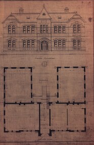 Federation University Historical Collection
Plan, School of Mines, Ballarat: Front elevation plan for new building, 1899, 1899
Mounted photocopy of plans for 1899ballarat school of mines, plan, front elevation, new classrooms, administration building, a building, architectural drawing -
 Kew Historical Society Inc
Plan - Subdivision Plan, Tregarron Estate, Kew, c.1929
Pru Sanderson, in her groundbreaking ‘City of Kew Urban Conservation Study : Volume 2 - Development History’ (1988), summarised the periods of urban development and subdivisions of land in Kew. The periods that she identified included 1845-1880, 1880-1893, 1893-1921, 1921-1933, 1933-1943, and Post-War Development. These periods were selected as they represented periods of rapid growth or decline in urban development. An obvious starting point for Sanderson’s groupings involved population growth and the associated economic cycles. These cycles also highlighted urban expansion onto land that was predominantly rural, although in other cases it represented the decline and breakup of large estates. A number of the plans in the Kew Historical Society’s collection can also be found in other collections, such as those of the State Library of Victoria and the Boroondara Library Service. A number are however unique to the collection.Subdivision plans are historically important documents used as evidence of the growth of suburbs in Australia. They frequently provide information about when the land was sold on which a built structure was subsequently constructed as well as evidence relating to surveyors and real estate and financial agents. The numerous subdivision plans in the Kew Historical Society's collection represent working documents, ranging from the initial sketches made in planning a subdivision to printed plans on which auctioneers or agents listed the prices for which individual lots were sold. In a number of cases, the reverse of a subdivision plan in the collection includes a photograph of a house that was also for sale by the agent. These photographs provide significant heritage information relating house design and decoration, fencing and household gardens.In January 1929, the Kew City Council called for tenders to construct Tregarron Avenue. The subdivision of the Tregarron Estate in Kew was for 11 lots bordering Tregarron Avenue and its entrance from Burke Road. The plan includes annotations that indicate the measurement of each block and the placement of the drainage and sewerage easements. This plan is interesting for a number of factors. The house blocks today have different street numbers, some blocks were to be further subdivided, and at the time of the subdivision, alterations were still being made to the extent of lots offered; lots 2 and 3 on the plan were subdivided and reoriented.subdivision plans - kew, tregarron estate, tregarron avenue -- kew (vic.), burke road -- kew (vic.) -
 Federation University Historical Collection
Plan, Ballarat School of Mines New Workshops, 17/11/1944
Hand drawn planballarat school of mines, new workshops, albert street -
Port Melbourne Historical & Preservation Society
Plan - US Military use of Port Melbourne Cricket Ground, Sverdup & Parcel, Architects and Engineers, 1940s
American military plan of Port Melbourne Cricket Ground, alterations to grandstand and rooms during WWII, 1940s.Plan drawn up by Sverdup & Parcel, Architects and Engineers.war - world war ii, sport - australian rules football, sport - cricket, sport - recreational grounds -
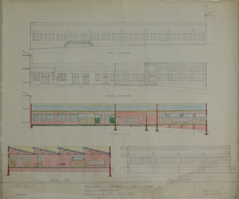
 Federation University Historical Collection
Plan, Ballarat School of Mines Clay Mill Building Alterations, 1962, 04/10/1962
Two plans for alterations to the Ballarat School of Mines Clay Mill Building to the Fluid Mechanics Labratory. .1) Existing Clay Mill Building .2) Plan and sections of proposed changes to the Clay Mill Building.john e. dixon, clay mill building, ceramics, ballarat school of mines, battery building -
Stawell Historical Society Inc
Plan, A Master Plan for Central Park Stawell, 2000
Grey Cover. Fawn binder a4 SizeMay 2000 Prepared for the Northern Grampians Shire Councilsport, central park, northern grampians shire -
Glen Eira Historical Society
Plan - Monkleigh, Gladstone Parade, 12, Elsternwick
This file contains three items, the first a typed evaluation of Monkleigh to J.C. Ellis, Esq. from A.E. Lillie dated 02/12/1907. Also included is an original memo to J.C. Ellis, Esq. from A.E.Lillie dated 14/05/1908 with description and condition of house. Also included is a plan with outline dimensions of Monkleigh Land Unattributed, undated, handwritten note that Colin Wimberley lived at Monkleigh according to Sands and McDougall directory 1911.glenhuntly road, elsternwick, ellis j. c., lillie a.e., caulfield, gladstone parade, architectural features, monkleigh, trevelyan street, mansions -
Port Melbourne Historical & Preservation Society
Plan - Port Melbourne Yacht Club reconstruction, Taylor Howden Pty Ltd, Architects, c. 1990
Clubhouse burned 14 February 1990 and was rebuilt with volunteer labour over many years (opened 1998)Plan of Port Melbourne Yacht Club clubhouse reconstruction 1990 - Preliminary sketch plans; faded almost to illegibilitybuilt environment - recreational facilities, societies clubs unions and other organisations, port melbourne yacht club, pmyc, taylor howden pty ltd -
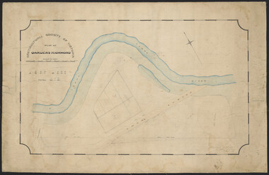
Glenelg Shire Council Cultural Collection
Plan - Town Plan - Cape Bridgewater, 02/04/1992
Black and white photocopy of an old plan of a subdivision at Cape Bridgewater. Two halves joined together with sellotape. Black texta numbers on some of the lots 1 - 28Front: 'OLD MAP' handwritten, top edgeplan, town planning, cape bridgewater -
 Kew Historical Society Inc
Plan - Subdivision Plan, Myrtle Park Estate, City of Camberwell, 1916
The Kew Historical Society collection includes almost 100 subdivision plans pertaining to suburbs of the City of Melbourne. Most of these are of Kew, Kew East or Studley Park, although a smaller number are plans of Camberwell, Deepdene, Balwyn and Hawthorn. It is believed that the majority of the plans were gifted to the Society by persons connected with the real estate firm - J. R. Mathers and McMillan, 136 Cotham Road, Kew. The Plans in the collection are rarely in pristine form, being working plans on which the agent would write notes and record lots sold and the prices of these. The subdivision plans are historically significant examples of the growth of urban Melbourne from the beginning of the 20th Century up until the 1980s. A number of the plans are double-sided and often include a photograph on the reverse. A number of the latter are by noted photographers such as J.E. Barnes.The ‘Myrtle Park Estate’ was a subdivision bounded by Victoria Road (now Lansdowne Street), Buchanan Avenue and Dight Avenue. Other streets that were created by the subdivision included Eurolie Street, Boorahman Street and Moody Street (now Sylvan Street). The Estate took its name from Myrtle Park (later changed to Macleay Park), which had been created in 1923 by Camberwell Council. The Park adjoined the southeast corner of the new subdivision. The Estate included 74 regular allotments characterised by narrow frontages and long blocks. Confusion may have greeted prospective purchasers as the Estate was advertised in the daily newspapers as being in East Kew, rather than in Camberwell, where it was at that stage located.subdivision plans - balwyn, myrtle park estate - camberwell [surrey hills] -
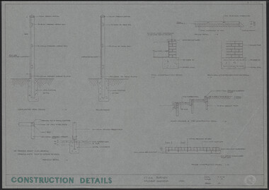 University of Melbourne, Burnley Campus Archives
Plan, Construction Details Student Gardens Burnley Campus, 1990
Tracing paper copy, Construction details for student gardens. Dated1 9.09.1990. By JK (Jill Kellow) . Scale 1:100.student gardens, burnley, vcah burnley, jill kellow -
Glenelg Shire Council Cultural Collection
Plan - Plans / Line Drawings - Port of Portland Authority Slipway Tug Buccaneer, Victoria, 30/09/1989
Port of Portland Authority -
Port Melbourne Historical & Preservation Society
Plan - Rebuilding library, Liardet Street, Port Melbourne, Linkon Design and Construction, 1987
.01 - Blueprint of 1987 plan for rebuilding library in Liardet Street (2 copies). .02 - Blueprint of 1987 Plan for Library in Liardet St - Electrical Services (2 copies)market reserve, linkon, city of port melbourne engineering dept, port melbourne library, built environment - civic, liardet street -
University of Melbourne, Burnley Campus Archives
Plan, The Heyington Diversion
yarra, river, freeway -
Clunes Museum
Plan - ARCHITECTS PLANS, KEVYN JOY ARCHITECTS, 12 JUNE 2009
PROPOSED CLUNES NEIGHBOURHOOD HOUSE PLAN TEMPLETON STREET 2009clunes neighbourhood house, proposed plans, templeton street -
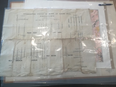 Federation University Historical Collection
Plan, Underground Survey of Mines at Spring Hill - Sections
This plan is associated with former Ballarat School of Mines Student Richard Squire (1875-1876). Printed (in black ink) sections of underground mines on cream paper. 120 feet to one inch scale.Numbers written in pencil along bottom of plan. madam berry, lord harry, berry consols, west loughlin, loughlin, west ristori, ristori, mining, gold mining, gold, underground survey -
Glenelg Shire Council Cultural Collection
Plan - Plans - Port of Portland Slipway Steel Vessel 'Cape Peron', n.d
port of portland -
Glenelg Shire Council Cultural Collection
Plan - Plan - Country Roads Board Specifications, n.d
Port of Portland Authority Archivesport of portland archives -
 University of Melbourne, Burnley Campus Archives
Plan, Horticultural Society of Victoria Plan of Gardens, Richmond, 1865
Plan on linen-backed paper of Burnley Gardens showing Yarra River, Swan St., railway, plan of west orchard and old garden sketched by hand in pencil. Inscription, "Presented to the Society, by A. Purchas C.E." Shows acreagesInscription, "Presented to the Society, by A. Purchas C.E." Oct 4th 1865"gardens, richmond, a. purchas, horticultural society of victoria