Showing 1644 items
matching documentation
-
 Bialik College
Plan (item) - Site development proposals, Shakespeare Grove, 1986
Site development proposals for 6 Shakespeare Grove, Hawthorn, as part of the Bialik College Strategy Plan, created by Jennings Project Management, October 1986. Includes plan of existing land use and site constraints. Please contact [email protected] to request access to this record.1980s, building and planning -
Glenelg Shire Council Cultural Collection
Plan - Ship Plan / Mould, n.d
Wooden pattern for mould for boat fitting. Boomerang shaped flat base, strip of ply wood attached at right angles to base, with copper nails, shaped block attached to underside of base with copper nails. Top painted cream, underside unpainted. -
 Kew Historical Society Inc
Plan - Subdivision Plan, Plan of Subdivision of Part of Crown Portion 84 / Parish of Boroondara / County of Bourke / Lodged Plan No. 2217, Twentieth Century
Pru Sanderson, in her groundbreaking ‘City of Kew Urban Conservation Study : Volume 2 - Development History’ (1988), summarised the periods of urban development and subdivisions of land in Kew. The periods that she identified included 1845-1880, 1880-1893, 1893-1921, 1921-1933, 1933-1943, and Post-War Development. These periods were selected as they represented periods of rapid growth or decline in urban development. An obvious starting point for Sanderson’s groupings involved population growth and the associated economic cycles. These cycles also highlighted urban expansion onto land that was predominantly rural, although in other cases it represented the decline and breakup of large estates. A number of the plans in the Kew Historical Society’s collection can also be found in other collections, such as those of the State Library of Victoria and the Boroondara Library Service. A number are however unique to the collection.The Kew Historical Society collection includes almost 100 subdivision plans pertaining to suburbs of the City of Melbourne. Most of these are of Kew, Kew East or Studley Park, although a smaller number are plans of Camberwell, Deepdene, Balwyn and Hawthorn. It is believed that the majority of the plans were gifted to the Society by persons connected with the real estate firm - J. R. Mathers and McMillan, 136 Cotham Road, Kew. The Plans in the collection are rarely in pristine form, being working plans on which the agent would write notes and record lots sold and the prices of these. The subdivision plans are historically significant examples of the growth of urban Melbourne from the beginning of the 20th Century up until the 1980s. A number of the plans are double-sided and often include a photograph on the reverse. A number of the latter are by noted photographers such as J.E. Barnes.Undated Plan of Subdivision of Crown Portion 84 in what is now Kew. The area shown is bordered by Burke Road, Harp Road, Arglye Road and Normanby Road.subdivision plans -- kew (vic), harp road, burke road, normanby road, lady loch's drive, gladstone street, second avenue, first avenue -
University of Melbourne, Burnley Campus Archives
Plan, Detail Plan of Victoria Park, 1976
Swinburne College of Technology Ltd. Plan dated July 1976. Survey Plan, Sheet 1 of 2 by Alan Baker, Terry Martin, Richard Yeoman.swinburne college of technology, alan baker, terry martin, richard yeoman, kew -
 University of Melbourne, Burnley Campus Archives
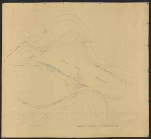
Plan, Department of Public Works, Burnley School of Horticulture, c.1951
Department of Public Works, Melbourne, Victoria plan No. 51/66 of extension of grounds. Area bounded by Yarra River to north and south. Additional areas coloured. Position of new buildings and new house shown.burnley school of horticulture -
 Port Melbourne Historical & Preservation Society
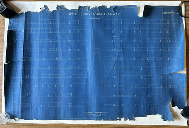
Plan, Pt Melbourne Cable Tramway, 1890s
One of three sheets of blueprints showing street configuration in Beach Street and Sandridge Road along Port Melbourne cable tram route. Indistinguishable signature of 'George ------ Esq., lower rightNotations in red crayon or penciltransport - tramways, transport - roads -
Moorabbin Air Museum
Plan (Item) - Airtrainer CT4 Plans
-
 Federation University Historical Collection
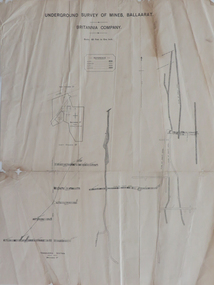
Plan, Underground Survey of Mines, Ballaarat, Britannia Company, not dated
Printed underground survey of the Britannia Companyunderground survey, britannia company, last chance company, transverse section -
Port Melbourne Historical & Preservation Society
Plan - Raglan Street from Williamstown Street to Ross Street, 14 Mar 1893
Plan of Raglan Street from Williamstown Road to Ross Street, 1893engineering - roads streets lanes and footpaths, town planning, town clerks, mayors, arthur victor heath, james john bartlett -
University of Melbourne, Burnley Campus Archives
Plan, Site plan 48 Barnard Grove Kew, 1995-1998
(1) Set of drawings - Folio 1995 by Meghan Bate includes Preliminary Plan 48 Barnard Grove Kew dated 1.6.95. (2) Tracing paper Site Plan. Scale 1:100. Unnamed. (3) Photocopy of Preliminary Plan of 'Hill Residence 48 Barnard Grove Kew' by Joanna Cutter, p3 of 4, dated 01.06.1998. Scale 1:100.kew, joanna cutter, meghan bate -
 Federation University Historical Collection
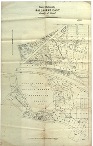
Plan, Ballaarat East Town Allotments, 1891, 18/09/1891
Ballarat East was historically a separate municipality than Ballaarat. The streets developed along gold leads and early tracks. The Public Park Botanic Gardens and Recreation Reserve is now Mount Xavier Golf Course, and Ballarat Secondary College Eastern Campus. The section with Bettle's Private Property is now Saint Francis Xavier Primary School. Elford Street now appears to be the continuation of Eureka Street.Plan of Town Allotments for a portion of Ballarat East in the County of Grant. It shows Victoria Street, Clifford Street, Finlay Street, Ryan Street, Bradbury Street, Elford Street, Fussell Street, Jones Street, Park Parade, Ballarat -Geelong Railway, Eureka Street, Ballarat East Public Park Botanic Garden and Recreation Reserve. The only allotment names is Bettle's Private Property. Gift of the Squire Family, 2014ballarat east, ballaarat east, victoria street, ballarat east botanical gardens, richard squire, squire, ryan street, jones street, bradbury street, humffray steet, fussell street, elford street -
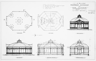 Friends of Ballarat Botanical Gardens History Group
Plan, J.B Vernon et al, City of Ballaarat Statuary Pavilion at the Gardens, September 1970
Sections, elevations and floor plan for pavilionPhotocopyplan, drawings, statuary pavilion -
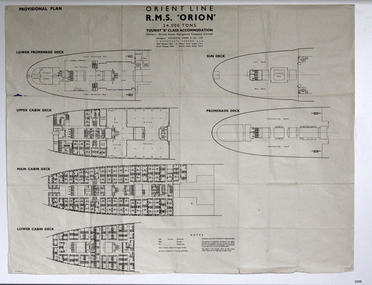 Flagstaff Hill Maritime Museum and Village
Plan - Ship Plan, Orient Steam Navigation Company, Orient Line, RMS Orion, ca. 1934
The Orient Steam Navigation Company Limited launched the Ocean Liner RMS Orion in 1934 and it remained in operation until 1963. The twin screw steamship was built to carry first class and tourist class passengers, over 1100 in all, plus almost 500 crew from Europe to Australia in comfort. The ship had a single funnel and a single mast. During WWII the vessel served as a troop carrier. The ventilation system noted on the plan, Punkah Louvre System, was designed for heating fresh air ventilation in buildings, ships and railroads. The system originated from Thermotank in Glasgow, Scotland. The ship plan for the RMS Orion is significant for its connection with the vessel. The ship was a leader, with several 'firsts'; the first Orient Line ship to be built with a single funnel since 1902, and the first to be painted in the Orient Line's livery, with a corn-coloured hull. It was the first liner to use chromium and bakelite materials for the surfaces throughout the ship, which provided greater resistance to the sea. It was also the first British ship to be fitted with air conditioning.Plan: printed provisional line drawing of the Orient line vessel "R.M.S. Orion". Inscriptions are printed on the plan. There are diagrams of six decks included in the plan. The ship is built for tourist "B" accommodation. The plan's Notices include details of the cabins including wardrobes, drawers, hinged seats, mattresses and bunk numbers. It also notes that there is a Punkah-Louvre System of Ventilation.Printed on the plan: "PROVISIONAL PLAN" "LOWER PROMENADE DECK" "UPPER CABIN DECK" "MAIN CABIN DECK" "LOWER CABIN DECK" "SUN DECK" "PROMENADE DECK" "ORIENT LINE / R.M.S. "ORION" / 24,000 TONS / TOURIST "B" CLASS ACCOMMODATION" "Owners: Orient Steam Navigation Company Limited"' "Managers : ANDERSON, GREEN & CO. LTD" "7 BISHOPS GATE, LONDON, E.C.2" "Chief Passenger Office : 14 Cockspur Street, London, S.W.1" "Branch Passenger Office : 1 Australia House, Strand, W.C.2" "notices"flagstaff hill, flagstaff hill maritime museum and village, warrnambool, maritime museum, maritime village, great ocean road, shipwreck coast, rms orion, plan, ship plan, provisional plan, orient line, orient ship, vissel orion, class b passenger accommodation, punkah louvre system of ventilation, deck plan, ship ventilation, ship floor plan, orient steam navigation company limited, anderson green & co ltd, steamship, ocean liner, war ship, troop carrier -
University of Melbourne, Burnley Campus Archives
Plan, Victoria University of Technology Melton Campus, 1994
Photocopy of 'Feature and Level Survey' plan by WBCM group. Job No 4776/5 Sheet 1 of 1. Compilation Sheet Part of 477630A and 477631A. Dated 06.07.1994. Drawn b y RVvictoria university of technology, melton, wbcm surveys pty. ltd., feature survey -
 Federation University Historical Collection
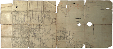
Plan, Creswick, County of Talbot
This plan is associated with former Ballarat School of Mines Student Richard Squire (1875-1876). Gift of the Squire Family, 2014 Plan showing allotments in Creswick, County of Talbot. The plan is in a number of pieces with some sections missing.creswick, creswick creek, spring hill, sarah paterson, lehman, mullins, spittle, squire, richard squire -
Port Melbourne Historical & Preservation Society
Plan - Soundings, Webb Dock, Port Melbourne, Operation Division, Port of Melbourne Authority, Jul 1987
Port of Melbourne Authority. Plan: soundings taken at Webb Dock, Port Melbourne, Berhs 1 to 5, approachesmelbourne harbor trust - port of melbourne authority, webb dock -
Port Melbourne Historical & Preservation Society
Plan - Tide limits at Inner East berth Station Pier for Tasmanian ferry Abel Tasman, Engineering Division, Port of Melbourne Authority, 1984
Plan: Tasmanian ferry at Inner East Station Pier - tide limits at working draft (lowest tide). This plan relates to the vessel Abel Tasmanabel tasman, piers and wharves - station pier, melbourne harbor trust - port of melbourne authority -
Moorabbin Air Museum
Plan (item) - Washer Spacing SD-E 270
-
Port Melbourne Historical & Preservation Society
Plan - North west elevation, Port Melbourne Town Hall, Engineering Department, City of Port Melbourne, 1915
Plan of new (1915) Town Hall, Port Melbourne (proposal ?). North west elevation, longitudinal section, front elevation, cross section A-A, section B-B.port melbourne town hall -
Port Melbourne Historical & Preservation Society
Plan - Liardet Community Centre, Port Melbourne, Barry Merat, Architect, 1988 - 1989
Set of 3 preliminary drawings, plan for remodelling former Temperance Hall as new "Liardet Community Centre" (in use at this time as Senior Citizens' Centre and Children's Library) - copied from sketches then coloured. 1988.built environment - civic, port melbourne temperance hall, barry merat, liardet community centre -
University of Melbourne, Burnley Campus Archives
Plan, Como, 1983, 1993
(1) Como Plant Inventory: Rear of House - Big Pond Lawn, Fountain Terrace and The Paddock dated November 1983, Landform Australia - photocopy in 2 sheets. Numbered list of plants and placement. (2) 2 copies Blueprint - Automatic Watering System Legend by Planned Irrigation Projects Pty. Ltd. (3) Tracing paper and paper plans of Croquet Lawn and Pony Paddock 'Como', Como Avenue, South Yarra - Landscape Studies Assignment 1993.como house, plant inventory, south yarra, irrigation -
University of Melbourne, Burnley Campus Archives
Plan - Plan, aerial photograph, Works Plan Scale 1:2000 [Aerial photograph of quarry]
In pencil on back of photograph: Lilydale Quarry Grid & a photolilydale, quarry -
Port Melbourne Historical & Preservation Society
Plan - Port Melbourne Yacht Club reconstruction, Taylor Howden Pty Ltd, Architects, c. 1990
Clubhouse burned 14 February 1990 and was rebuilt with volunteer labour over many years (opened 1998)Plan of Port Melbourne Yacht Club clubhouse reconstruction 1990 Plan of rebuilt clubhouse; faded almost to illegibilitybuilt environment - recreational facilities, societies clubs unions and other organisations, port melbourne yacht club, pmyc, taylor howden pty ltd -
University of Melbourne, Burnley Campus Archives
Plan, Melbourne Girls College, 1980s?
Coloured, laminated, Concept Plan for Courtyard between Portables and East Elevation Main Building. Scale 1:100. Student: Redna Moore, on reverse.melbourne girls college, redna moore, students, courtyard -
Moorabbin Air Museum
Plan - Drawings: 88732 (Proposed D/F Aerial, D/F Aerial Proposed Layouts, Aerials Arrangement, Aircraft Sealing, Cabinet Layout, Proposed Mounting, Proposed ‘Porters Installation), 89685 - Aerial Column Assembly, 89686 - Aerial Assembly, 89688 - Housing Top, 89689 - Housing Bottom, 89690 - Housing, 89691 - Screen, 89696 - Assembly Aerial Flange, 89699 - Flange, 8o702 - Stub Shaft, 89703 - Tube Inner, 89704 - Housing, 89705 - Bearing Upper, 89706 - Block Lamps, 89707 - Bracket, 89708 - Body, 89709 - Plate Illuminating, 89710 - Stop Plate, 89711 - Block Plug Mount, 89712 - Cap, 89713 - Scale, 89714 - Spacer, 89715 - Catch Pin, 89780 - Aerial Assembly, 89791 - Top Steady Anchorage Assembly, 90072 - Modifications Cessna, 90376 - Aerial Assembly Porter, 90391 - Modifications Porter, 90405 - Drilling Jig, o3031 - Experimental Auxiliary Aerial Project Thorough, Weapons Research Establishment
-
Glenelg Shire Council Cultural Collection
Plan - Plan - Port of Portland Slipway, Twin Screw Tug, 16/03/1981
Front: - black texta, top right cornerport of portland -
Port Melbourne Historical & Preservation Society
Plan, The Township of Sandridge, 30 Mar 1859
Plan of the township of Sandridge.Lithographed at the Public Lands Office, Melbourne, March 30th 1859engineering - roads streets lanes and footpaths, municipal district of sandridge -
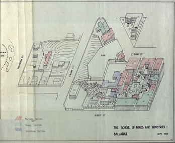 Federation University Historical Collection
Plan, Plan of the School of Mines and Industries Ballat, 1963, 09/1963
Plan of the Ballarat School of Mines and Insustries from Albert Street.ballarat school of mines, white flat, white flat oval, hickman street, grant street, albert street -
Port Melbourne Historical & Preservation Society
Plan - Change room, addition, Station Pier, Port Melbourne, Melbourne Harbor Trust, 19 Jun 1963
Plan (working drawing) for addition of change room at Station Pier.piers and wharves - station pier, melbourne harbor trust - port of melbourne authority -
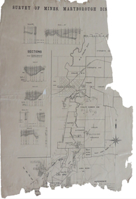 Federation University Historical Collection
Plan, Survey of Mines, Maryborough District, not dated
Maryborough is a Central Victorian town. Printed section of the Maryborough Districtmaryborough, carisbrook, majorca, horizontal sections, vertical sections, chalk's no 4, east kong meng, craigie