Showing 1648 items in the category Documentation with item type Plan
-
 Glenelg Shire Council Cultural Collection
Plan - Plans / Line Drawing Port of Portland Slipway Twin Screw Tug 'Kalimni', 16/03/1981
Front: '14' - black texta, top right cornerport of portland -
Glen Eira Historical Society
Plan - Clarinda Street, 27, Caulfield South
A one page typed letter from Plante and Henty Solicitors on behalf of the Executor of the will of the late Grace Ellen Gillespie, to W V Scott of S P Simmonds and Co, dated 04/03/1957, requesting valuation of 27 Clarinda Street, Caulfield South for Probate purposes. The letter is accompanied by the Certificate of Title for the property which includes a map (87mm x 67mm) of the property. It is also accompanied by a floor plan (300mm x 205mm) of the house. The file also includes a two page copy of correspondence from W V Scott to Plante and Henty, dated 22/03/1957, providing the valuation of 27 Clarinda Street. The file also includes three pages of handwritten working notes for the purposes of the valuation which provide dimensions and estimated value of the property.scott w v, gillespie grace ellen, clarinda street, solicitors, s p simmonds and co estate agents, property values, land values, plans, architectural features, land titles, certificates, caulfield south, prahran east, elsternwick county of bourke, sycamore road, south caulfield, glenhuntly road -
Old Colonists' Association of Ballarat Inc.
Plan, R & R Planning and Development Consultants Pty Ltd, Drainage Plans for Charles Anderson Grove Retirement Village, 2016
Three PDFs relating to drainage at the Charles Anderson Grove Retirement Village in Ballarat. charles anderson grove, retirement village, drainage, plans, sewerage, architectural plans -
 Port Melbourne Historical & Preservation Society
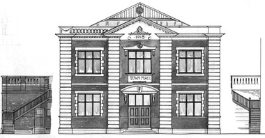
Plan - North west elevation, Port Melbourne Town Hall, Port Melbourne City Council, 1915
Plan - new (1915) Town Hall Port Melbourne, north west elevation, lonitudinal section A-A. Front elevation. Cross section B-B, Section C-C.port melbourne town hall -
Port Melbourne Historical & Preservation Society
Plan - Annotated and handcoloured by Peter Libbis to indicate his research into Libbis family residences and hotels on copy of a section of an MMBW map, Melbourne and Metropolitan Board of Works, c. 1980s
Peter LIBBIS obtained these copies from the MMBW when he researched his family history in the 1980s. He has annotated them, colour in hotels etc. Donated to Society in 1997.One of a group of 19 photocopies of various 20th century MMBW plans, annotated/coloured in to indicate residences of Libbis family and local hotels, by Peter LIBBIS in family and hotel research - Railway yards, Ross and Clark, South Graham c 1950sbusiness and traders - hotels, built environment - domestic, transport - railways, melbourne and metropolitan board of works, libbis family -
Glenelg Shire Council Cultural Collection
Plan - Ship Plan / Mould, n.d
Wooden pattern for mould for boat ftting. Flat back, front semi circular, painted brown.Front: "A STANKE PORTLAND' - black texta -
Clunes Museum
Plan - PLANS CLUNES CARAVAN PARK, NO. 1 - SHIRE OF TALBOT & CLUNES. IAN MANSLEY, SHIRE ENGINEER NO. 2 - LEO MCMAHON & ASSOCIATES PTY. LTD. LICENSED SURVEYORS & ENGINEERS, 31 LYONS ST. NTH. BALLARAT, 1976
NO. 1 PLAN - CLUNES CARAVAN PARK ENGINEER - IAN MANLEY NO. 2 PLAN - SECTION 15 TOWNSHIP OF CLUNES, COUNTY OF TALBOT, BY LEO MCMAHON AND ASSOCIATES, LICENSED SURVEYORS AND CIVIL ENGINEERSplans, caravan park, ian manley, plan section 15 -
Glenelg Shire Council Cultural Collection
Plan - Ship Plan / Mould, n.d
Wooden pattern for mould for boat fitting. Rectangular base, 2 mounds attached to top of base, equidistant from short ends. Top painted green, underneath base, painted white. -
 University of Melbourne, Burnley Campus Archives
Plan, Department of Public Works, Nursery Potting Soil Bins, 1941
Plan for removal and re-erection of soil bins by Dept. of Public Works. P.P.M. Engineer.burnley school of horticulture, nursery -
 Kew Historical Society Inc
Plan, City Engineers Department (Heidelberg), City of Heidelberg Plan: Scale 20 chns to 1 inch, 1970-1993
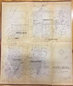
Gwen Barton McWilliam (nee: Nelson), OAM, BA (1933- ). Gwen McWilliam is well known as an authority on the history of Boroondara and the author of a large number of books and pamphlets about the City. She was awarded the medal of the Order of Australia in 2001 ‘for service to the community of Hawthorn and district, particularly through the research, documentation and publication of its history.’ Primary source annotated by a distinguished local historian.Plan of number of areas in the City of Heidelberg showing municipal and ward boundaries, subsequently annotated by the historian Gwen McWilliam, identifying significant landholdings, subdivisions and key dates.The base map was printed in 1970 and annotated c.1993. The plan was donated to the Kew Historical Society by Gwen McWilliam. Handwritten annotations by Gwen McWilliam, 1993city of heidelberg, maps -- heidelberg (vic.), gwen mcwilliam -
 Kew Historical Society Inc
Plan, Melbourne & Metropolitan Board of Works : Contour Plan of Melbourne & Suburbs : Melbourne Sewage, 1894
The Melbourne and Metropolitan Board of Works (MMBW) plans were produced from the 1890s to the 1950s. They were crucial to the design and development of Melbourne's sewerage and drainage system. This plan forms part of a large group of MMBW plans and maps that was donated to the Society by the Mr Poulter, City Engineer of the City of Kew in 1989. Within this collection, thirty-five hand-coloured plans, backed with linen, are of statewide significance as they include annotations that provide details of construction materials used in buildings in the first decade of the 20th century as well as additional information about land ownership and usage. The copies in the Public Record Office Victoria and the State Library of Victoria are monochrome versions which do not denote building materials so that the maps in this collection are invaluable and unique tools for researchers and heritage consultants. A number of the plans are not held in the collection of the State Library of Victoria so they have the additional attribute of rarity.Digital copy of an original MMBW plan. This contour plan shows the area identified by the MMBW for purposes of drainage and sewerage in 1894. The suburbs represented extend from Williamstown in the west to Bulleen in the east, and from Preston in the north, south to Sandringham. Suburbs are outlined in coloured ink. Red lines indicate main and branch sewers in existence at the beginning of 1894 in central and inner Melbourne. These extended as far as Williamstown and Brighton, but not yet as far as Kew, where sewering did not commence until 1901. Contour lines show the topography, which was important for indicating the fall of the land for the laying of sewers and drainage channels. Kew appears to be fairly undeveloped at this date except for railway lines and stations (the Kew and Outer Circle lines), main roads, the Kew Lunatic Asylum Reserve and Studley Park. However, the contour plan does not accurately represent the density of settlement, nor the large number of houses, which were being built in Kew and other suburbs from the 1850s to the land boom of the late 1880’s and early 1890’s. This plan is part of a large and historically significant group of MMBW plans and maps that was donated to the Society by the Mr Poulter, City Engineer of the City of Kew in 1989.mmbw contour plan of melbourne and suburbs, melbourne and metropolitan board of works, melbourne sewage, cartography -
University of Melbourne, Burnley Campus Archives
Plan, Orchard plans, 1959-1966
Handwritten and typed roneo copies, with amendments. (1) Apple Block at October 1959. (2) Pear Block at October 1959. (3) Plum Block at 16/5/60. (4) Citrus Block at 1/3/60. (5) Citrus Block at 13/10/60 and Plum-Apricot Block at 8/10/60. (6) Misc. Fruits, Peach, Nectarine, Apricot, Almond & Fig Block at Oct. 1960. (7) Berry Block at 25 Oct 1960. (8) Apple Block at October 1960. Pear Block at October 1960. (9) Citrus Block June 1966. (10) Apple Block June 1966. (11) Quinces, figs, almonds, apricots, peaches. (12) Peach, Nectarine, Apricot, Almond and Fig Block June 1966fruits, orchards, pruning, apples, pears, plums, citrus, burnley field station -
Moorabbin Air Museum
Plan (item) - Bristol Aeroplane 170 schematic drawings, Gusset Outer Wing
Bristol Aeroplane Company -
Moorabbin Air Museum
Plan (item) - C.A.C Turbojet Trainer A.S. Viper XP.59 P269
-
 Federation University Historical Collection
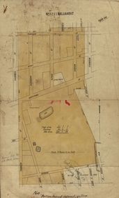
Plan, Ballaarat No 5722, 28/11/1903
Part of the block shaded yellow on the plan contains Phoenix P-12 School Senior CampusPlan of Ballarat with leae area No 5722 coloured yellow. Plan of the streets around Hertford Street, ballarat. The yellow depicts the area leased (No 5722 Ballarat)mining lease 5722 ballarat, ballarat, hertford street, cromwell street, alexandra street, alfred street, verdon street, clarkson street, spencer street, franklin street, hill street, grant street, albion street, rowlands street, edwards street north, mining, cgt, plans, phoenix p-12 school senior campus -
Moorabbin Air Museum
Plan (item) - Ram-Jet Helicopter No.1 Scale 1/24
-
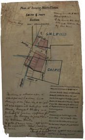 Federation University Historical Collection
Plan, Plan of Smith & Party's Quartz Block Claim, Redan, 27/10/1884
Hand drawn plan for smith and Party's quartz block plan in Redan, Ballarat.smith and party, redan, quartz block claim, mining, darling street, skipton street, cobden street, robert davidson, plans, cgt -
Port Melbourne Historical & Preservation Society
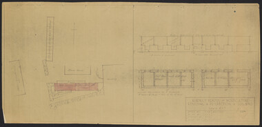
Plan - Port Melbourne Town Hall, c. 1915
Plan of 'New Town Hall' i.e. 1915Tiny calculations in pencil, bottom centre and right; contract no. (no signatures)port melbourne town hall -
Port Melbourne Historical & Preservation Society
Plan - Annotated and handcoloured by Peter Libbis to indicate his research into Libbis family residences and hotels on copy of a section of an MMBW map, Melbourne and Metropolitan Board of Works, c. 1980s
Peter LIBBIS obtained these copies from the MMBW when he researched his family history in the 1980s. He has annotated them, colour in hotels etc. Donated to Society in 1997.One of a group of 19 photocopies of various 20th century MMBW plans, annotated/coloured in to indicate residences of Libbis family and local hotels, by Peter LIBBIS in family and hotel research - Railway, Montague to Ingles Street (South Melbourne mostly)business and traders - hotels, built environment - domestic, transport - railways, melbourne and metropolitan board of works, libbis family -
Port Melbourne Historical & Preservation Society
Plan - Port Melbourne Yacht Club reconstruction, Taylor Howden Pty Ltd, Architects, c. 1990
Clubhouse burned 14 February 1990 and was rebuilt with volunteer labour over many years (opened 1998)Plan of Port Melbourne Yacht Club clubhouse reconstruction 1990 - Preliminary sketch plans; faded almost to illegibilitybuilt environment - recreational facilities, societies clubs unions and other organisations, port melbourne yacht club, pmyc, taylor howden pty ltd -
University of Melbourne, Burnley Campus Archives
Plan (Item), Graphics Portfolio Assessment - 31 Lynch Street Hawthorn, 1992
Mark given by teachergraphics, garden layout, hawthorn, emma williams -
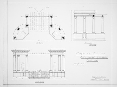 Friends of Ballarat Botanical Gardens History Group
Plan - Proposed Entrance to Gardens; Clegg and Morris Architects, Melbourne and Ballarat
Shows proposed elevations and sections of proposed structureHistoricPhotocopy ballarat botanical gardens, buildings, plan, entrance -
Port Melbourne Historical & Preservation Society
Plan - Traffic census, Port Melbourne, 6 Mar 1947
Traffic census 6th March 1947 showing intersections at Ingles Street and Williamstown Road (no 84), Lorimer Street and Salmon Street )no 90) Beach Street and Bay Street (no 113) Williamstown Road and Beach Road (no 112), Railway Crossing Graham Street (no 77)engineering - roads streets lanes and footpaths -
Moorabbin Air Museum
Plan (item) - Bristol Aeroplane 170 schematic drawings, Assembly Front Spar
Bristol Aeroplane Company Ltd -
Glenelg Shire Council Cultural Collection
Plan - Plan - Map Portland Harbour, n.d
Port of Portland Authority Archivesport of portland archives, portland harbour -
Port Melbourne Historical & Preservation Society
Plan - Metalling and channelling Evans Street from Ingles Street to Boundary Street, 14 Mar 1893
Specifications (94.1) and Plan (94.2) for metalling and channelling Evans Street from Ingles Street to Boundary Street . Loan Works 1893. Plan number 8.Both signed by J.J. Bartlett. (Mayor).engineering - roads streets lanes and footpaths, town planning, town clerks, mayors, arthur victor heath, james john bartlett -
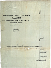 Federation University Historical Collection
Plan, Underground Survey of Mines Ballarat Dalzell-Cum-Prince Regent Co
Transverse sectionmining, cgt, dalzell-cum-prince, plans -
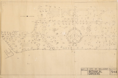 Friends of Ballarat Botanical Gardens History Group
Plan - Survey Plan A, G. Creek, City of Ballarat Botanical Gardens
HistoricSurvey map on papersurvey map, city of ballaarat, ballarat botanical gardens -
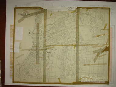 Federation University Historical Collection
Plan, Ballarat East, 1916, 24/05/1916
Plan of streets and allotments in Ballarat East. Includes: Bakery Hill, Canadian Station, Eureka Cemetery, Orphan Asylum, Eureka Gardens and Reserve, Gun Clubballarat east, bakery hill, eureka stockade site, eureka gardens, ballarat orphanage -
University of Melbourne, Burnley Campus Archives
Plan - Student Work, Grey Street Residence, December 2013
student work, assignment, landscape design, st kilda, b. terry, 3 generations