Showing 1651 items in the category Documentation with item type Plan
-
 Federation University Historical Collection
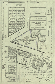
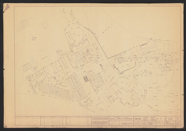
Plan, Ballarat School of MInes Allotments
-
 University of Melbourne, Burnley Campus Archives
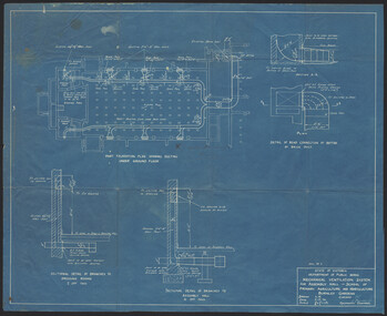
Plan, K.O. Wood, Mechanical Ventilation System, 1946
Blue print of mechanical ventilation system for Assembly Hall by K.O. Wood, Mechanical Engineer. Dated 9.7.'46.k.o. wood, mechanical engineer, ventilation -
 Ringwood and District Historical Society
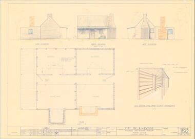
Plan - Ringwood Lake Reserve Museum Miners Cottage - 1983, Detailed Building Plans - 4 Sheets
Sheets 1, 2, 3 & 4 - Structural drawings for construction of miners cottage museum at Ringwood Lake Reserve, opened May, 1983. -
 Federation University Historical Collection
Plan - Engineering drawings, 'Coal Stage for Locomotive', 1975, 1972
William Gerard Griffiths was a student at the Ballarat Institute of Education when he completed this drawing.Pencil on paper student's technical drawing 'Coal stage for locomotive' civil engineering, technical drawing, w. g.griffiths, ballarat institute of advanced education, alumni, railway -
 Moorabbin Air Museum
Plan (Item) - Drawing Exterior Finishing Scheme Orion P3-B Aircraft , Drawing A16194, Sheet 1 Of 5 Sheets
-
 University of Melbourne, Burnley Campus Archives
Plan, M. Drake et al, Site Location Plan of Incubator Building and Random Sample Laying Test for Burnley Gardens, 1967
Plan by Public Works Dept., Melbourne. M. Drake (draughtsman), R. G. Wilson, Chief Architect.m. drake, g.r. wilson -
Stawell Historical Society Inc
Plan - Report, Shire of Stawell Roadside Management Plan, 1994
Compiled by Project Officer: Geraldine Monaghan, assisted by John Miller Researcher, LecturerPaper Stapled at Left top CornerWimmera Community Collage of TAFE: in pen - Shire of Stawell Logo -
Federation University Historical Collection
Plan - Plans, Barkly Street Girls' School Sewerage Plans, c1952
Two hand coloured sewerage plans .1) Barkly Street .2) as aboveplans, sewerage plans, percy everett, barkly street, ballarat east, girls' school -
 Federation University Historical Collection
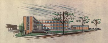
Plan, Ballarat School of Mines Building Development, 11/04/1964
With the development of tertiary education in the 1960s and 1970s the Ballarat School of Mines asked Coburn and Associates to design new buildings for the Ballarat School of Mines site, utilising the Ballarat Gaol site. The plans did not proceed, with the Mount Helen Campus being created instead. For information on Herbert L. Coburn go to http://guerin.ballarat.edu.au/curator/honour-roll/honourroll_Coburn,%20H.L.shtmlThree copies of plans by Coburn and Associates, with hand applied colour. The plans relate to a proposed development of the Ballarat School of Mines. .1) - shows the Ballarat School of Mines site, with proposed new buildings. It also shows buildings along Dana Street including the Ballarat Club, as well as White Flat. .2) View of proposed Library and Union Building .3) View of proposed Engineering Buildinguniversity of ballarat, ballarat school of mines, architect, herbert coburn, herbert l coburn, coburn and associates, architectural plans -
 Federation University Historical Collection
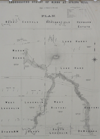
Plan, Underground Survey of Mines at Spring Hill, 1886
Plan printed by the Government Printing Office Melbourne, of underground survey at Spring Hill underground survey, spring hill, robert allen, c.w. langtree, steam litho government printing office -
 Federation University Historical Collection
Plan, French Patent Plan, 1899
Henry Sutton is a talented world-wide accepted inventor with inventions relating to the telephone, photography, wireless, cars, motorcycles, and bicycles as well as many more inventions. Henry was also one of four brothers that ran the Sutton's Music Store after the death of their Father Richard Sutton. Henry Sutton taught Applied Electricity at the Ballarat School of Mines in 1883 to 1886.Copy of plan used in the French patent of Henry Sutton french patent, henry sutton, plan, 1899 -
Port Melbourne Historical & Preservation Society
Plan - Sounding at Station Pier, Port Melbourne, Engineering Division, Port of Melbourne Authority, May 1985
Plan - Sounding at Station Pier taken May/June 1985.melbourne harbor trust - port of melbourne authority -
 Kew Historical Society Inc
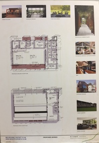
Plan - Architectural Sketch, MCC Kew Sports Club Proposed Works, 2012
Sports Clubs in Kew in the final decades of the 19th century and in the early 20th century were often umbrella organisations with facilities for a number of sports. Typically in Kew, this included teams in lawn bowls, tennis and croquet. The Kew Bowling Club was formed in 1880 while the privately owned Auburn Heights Recreation Club was opened in 1904. By 1998, the two Clubs decided to amalgamate at the Auburn Heights site in Barkers Road, forming the Kew Heights Sports Club. The combined club was itself taken over by the Melbourne Cricket Club in 2012 becoming MCC Kew Sports Club. In 2017 MCC Kew closed and its landholding was subsequently sold to Carey Baptist Grammar School. Both the Kew and Auburn Heights Clubs assembled important collections. These historically significant and large collections were donated to the Society in 2020. The collections include manuscripts, pictures, trophies, plans, honour boards etc. The combined collections of the four sporting clubs making up the collection number hundreds of items that are historically significant locally. They are also significant to the sporting history of the greater Melbourne area and to the sports of lawn bowls and tennis in Australia in the 19th and 20th centuries. The collection illuminates two of the Victorian historic themes - 'Building community life' through forming community organisations and 'Shaping cultural and creative life' by participating in sport and recreation.Architectural sketches on corflute of proposed designs for the new MCC Kew Sports Club by McIldowie Partners (Architects & Interior Designers), 2012. [The item forms part of the Kew Heights Sports Club collection (1998-2012), with items relating to the sports of lawn bowls and tennis, gifted to the Kew Historical Society in 2020].mcc kew sports club - barkers road - kew (vic), mcildowie partners -- architects, architectural sketches -
Tatura Irrigation & Wartime Camps Museum
Plan - Diagram/Plan, Lathe
Plan of a wood turning lathe made by internee at camp 3. diagram and description of each piece in the plan to make a wood turning lathe. Has been laminated.lathe plans, lathe diagram, rudy hoefer, woodworking equipment -
Clunes Museum
Plan - PLANS, YUNCKEN, FREEMAN & FREEMAN, CLUNES PUBLIC HOSPITAL ALTERNATIONS & ADDITIONS, 1935
SHEET OF PAPER, HAND DRAWN PLANS IN BLACK INK, INCLUDES ELEVATION VIEWSWRITTEN IN PENCIL ON REVERSE "PLANS RECONSTRUCTION CLUNES HOSPITAL (COPY) 1935clunes public hospital, yuncken, freeman -
 Kew Historical Society Inc
Plan, Melbourne & Metropolitan Board of Works : Borough of Kew : Detail Plan No.1576, 1904
The Melbourne and Metropolitan Board of Works (MMBW) plans were produced from the 1890s to the 1950s. They were crucial to the design and development of Melbourne's sewerage and drainage system. The plans, at a scale of 40 feet to 1 inch (1:480), provide a detailed historical record of Melbourne streetscapes and environmental features. Each plan covers one or two street blocks (roughly six streets), showing details of buildings, including garden layouts and ownership boundaries, and features such as laneways, drains, bridges, parks, municipal boundaries and other prominent landmarks as they existed at the time each plan was produced. (Source: State Library of Victoria)This plan forms part of a large group of MMBW plans and maps that was donated to the Society by the Mr Poulter, City Engineer of the City of Kew in 1989. Within this collection, thirty-five hand-coloured plans, backed with linen, are of statewide significance as they include annotations that provide details of construction materials used in buildings in the first decade of the 20th century as well as additional information about land ownership and usage. The copies in the Public Record Office Victoria and the State Library of Victoria are monochrome versions which do not denote building materials so that the maps in this collection are invaluable and unique tools for researchers and heritage consultants. A number of the plans are not held in the collection of the State Library of Victoria so they have the additional attribute of rarity.Original survey plan, issued by the MMBW to a contractor with responsibility for constructing sewers in the area identified on the plan within the Borough of Kew. The plan was at some stage hand-coloured, possibly by the contractor, but more likely by officers working in the Engineering Department of the Borough and later Town, then City of Kew. The hand-coloured sections of buildings on the plan were used to denote masonry or brick constructions (pink), weatherboard constructions (yellow), and public buildings (grey). Development in the 20th century has irreparably altered that part of Kew represented in this plan. In the block bounded by Cotham Road, Charles Street, Wellington Street and Gellibrand; just one house standing in 1903 remains. This block included two of the most historic houses in Kew: ‘Ordsall’ (later ‘Southesk’) and ‘Madford’ (previously ‘Elm Lodge’). Ordsall was the home of the second chairman of Kew, John Halfey. It contained some of the most significant interior murals in Kew, created for Halfey by artists working for Cullen & Co. It was demolished in 1960 to make way for the Kew Civic Centre. Elm Lodge had been built for William Siddeley in ca. 1864. Arthur Septimus King purchased it in 1874. The lower paddocks of Madford were sold in 1905 by his wife to the Borough of Kew and, after landscaping by George and Thomas Pockett, opened as the Alexandra Gardens in 1908. Elm Lodge/Madford was in 1922 to become St. Anthony’s Home for Little Children before its subsequent demolition in the 1980s.melbourne and metropolitan board of works, detail plans, maps - borough of kew, mmbw 1576, cartography -
Moorabbin Air Museum
Plan (item) - Bristol Aeroplane 170 schematic drawings, Plug Compt.Centre Plane
Bristol Aeroplane Company Ltd -
Glenelg Shire Council Cultural Collection
Plan - Original boat line plans of army diesel tug boat, 'Vigorous' (later renamed 'Emily S'), 10/07/1959
Eden Killer Whale MuseumOriginal boat line plans of army diesel tug 'Vigorous' later owned by Geoff Collett of Eden and later renamed 'Emily S' by Tony Santic. -
 University of Melbourne, Burnley Campus Archives
Plan, Landscape Construction, 1960-1990
Miscellaneous plans on tracing paper and paper related mainly to Landscape Construction (approx. 40 sheets)landscape construction -
Port Melbourne Historical & Preservation Society
Plan - Annotated and handcoloured by Peter Libbis to indicate his research into Libbis family residences and hotels on copy of a section of an MMBW map, Melbourne and Metropolitan Board of Works, c. 1980s
Peter LIBBIS obtained these copies from the MMBW when he researched his family history in the 1980s. He has annotated them, colour in hotels etc. Donated to Society in 1997.One of a group of 19 photocopies of various 20th century MMBW plans, annotated/coloured in to indicate residences of Libbis family and local hotels, by Peter LIBBIS in family and hotel research - Pickles/Crockford (South Melbourne mostly)business and traders - hotels, built environment - domestic, transport - railways, melbourne and metropolitan board of works, libbis family -
Moorabbin Air Museum
Plan (Item) - BAE Paper Hawk Aeroplane Plans
-
Moorabbin Air Museum
Plan (item) - Transportable Aeroplane Shed Erection Details DWG No.43/44/276
-
Moorabbin Air Museum
Plan (item) - C.A.C Rocket Boost Installation Avon Sabre P321 AP71
-
Glenelg Shire Council Cultural Collection
Plan - Ship Plan / Mould, n.d
Wooden pattern for mould for boat fitting. Rectangle, semi circle cut from one long side. Painted white, splashes of green. Copper nail embedded in curved section. -
 Falls Creek Historical Society
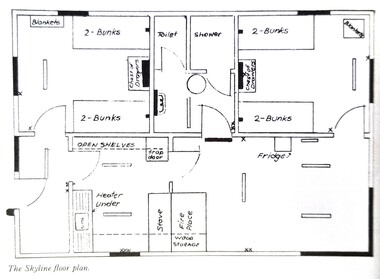
Plan - Floor plan Skyline Lodge, Bogong High Plains
MEYER COLLECTION - FALLS CREEK PHOTOS In 1947 a determined group of like-minded State Electricity Commission (SEC) staff including Ray Meyer, the chief surveyor of the Kiewa Hydro-Electric Scheme, had a common interest that revolved around the skiing potential of the snow-covered high plains which included what is now the resort of Falls Creek. The six SEC employees, Toni St Elmo, Ray Meyer, Jack Minogue, Lloyd Dunn, Adrian Ruffenacht and Dave Gibson (together with their families) banded together to secretly build a 'hut' that was the first ski lodge at Falls Creek. Using a road built in 1930s to gain access to Falls Creek, their hut project was carried out in secret as efforts by other skiers were blocked by H.H.C. Williams – the engineer in charge of the Hydro Scheme. In 1946 Ray Meyer made a trip to the Lands Office in Melbourne. He came away with a 99-year lease on three acres that was ideally suited for a hut designed by Lloyd Dunn. Adrian Ruffenacht (Design Engineer for the KHS) had suggested where the group should build because of easy access to a spring for water. Much of the building material required was scavenged from derelict huts on the high plains. Due to the need for secrecy, the determined group worked on the hut in the evenings and weekends to avoid detection. During the building period the group had met at Echidna Rock (now known as Eagle Rock) where Skippy St Elmo announced, "This is my favourite ‘Skyline’.” And so the first lodge in the area at Falls Creek Ski Resort came into existence. With the development of the International Poma in the 1970s, the Skyline Lodge, which was sited between the ski-lift’s pole one and pole two, was demolished. However, the legacy of Ray Meyer, Toni St Elmo, Jack Minogue, Lloyd Dunn, Adrian Ruffenacht and Dave Gibson and Skyline lives on in the vibrant atmosphere of Falls Creek Resort. The MEYER COLLECTION documents developments on the Kiewa Hydro Scheme and their life at Falls Creek from the mid 1930s to 1960s.This image is significant because it depicts developments made to "Skyline", the first lodge at Falls Creek.A floor plan of Skyline Lodge, probably after renovations were carried out by the Ski Club of Victoria which bought in to Skyline in 1950. In 1951 - 1952 a road up to the Lodge as well as drains, trenches and culverts were added. renovations to the lounge, basement drainage and porch resurfacing were completed in 1955. falls creek, victorian snowfields, skyline lodge -
Clunes Museum
Plan - PLANS CLUNES CARAVAN PARK, NO. 1 - SHIRE OF TALBOT & CLUNES. IAN MANSLEY, SHIRE ENGINEER NO. 2 - LEO MCMAHON & ASSOCIATES PTY. LTD. LICENSED SURVEYORS & ENGINEERS, 31 LYONS ST. NTH. BALLARAT, 1976
NO. 1 PLAN - CLUNES CARAVAN PARK ENGINEER - IAN MANLEY NO. 2 PLAN - SECTION 15 TOWNSHIP OF CLUNES, COUNTY OF TALBOT, BY LEO MCMAHON AND ASSOCIATES, LICENSED SURVEYORS AND CIVIL ENGINEERSplans, caravan park, ian manley, plan section 15 -
Moorabbin Air Museum
Plan (item) - CAC Wirraway Agricultural Conversion XP.77 Drawing, C.A.C Wirraway Agricultural Conversion XP.77, 02/1957
This schematic was drawn by W. J. Watkins for the Commonwealth Aircraft Corporation during February 1957. It shows the XP-77 experimental conversion of the Wirraway general-purpose military aircraft. This drawing appears to depict the early stages of the CAC's Ceres design, which later had limited success as an agricultural aircraft carrying out tasks such as crop spraying. As the prototype first flew in February 1958, this diagram represents part of the development process for that aircraft. It also demonstrates an important phase in the history of the CAC, where, after the Second World War, the company was innovating in an attempt to stay relevant after the rapid shrinking of the RAAF. -
University of Melbourne, Burnley Campus Archives
Plan, 25 Wakanui Street, 1996
Plans for a garden at 25 Wakanui Street [Northcote] by Holmes Design. (1) Point Location Data showing plumbing fixtures. (2) Tracing paper and paper copies Dwg No 13 Site Inventory & Analysis 4/6/96. Scale 1:100. (3) Coloured tracing paper and paper copies, Dwg No 15 Preliminary Plan 6/6/96. Scale 1:100. (4) Tracing paper and paper copies Dwg No 16 Section View Backyard 6/6/96. Scale 1:50. (5) Photocopy of Certificate of Title and Sewerage.wakanui street, holmes design, northcote, garden design -
Port Melbourne Historical & Preservation Society
Plan - Port Melbourne Town Hall, Engineering Department, City of Port Melbourne, 1915
Plan of new (1915) Town Hall, Port Melbourne. Foundation plan, ground plan, plan of balconies.port melbourne town hall -
Port Melbourne Historical & Preservation Society
Plan, The Township of Sandridge, 30 Mar 1859
Plan of the township of Sandridge.Lithographed at the Public Lands Office, Melbourne, March 30th 1859engineering - roads streets lanes and footpaths, municipal district of sandridge