Showing 1651 items in the category Documentation with item type Plan
-
 University of Melbourne, Burnley Campus Archives
Plan, Proposed Stores & Garage Renovations, 1997
Burnley Development Site for Amrad Operations Pty. Ltd. By Johnston Merat Kurdiovsky Pty. Ltd. Dated March 1997. Scale 1:100. (1) Site Improvements Plan. (2) Elevations - Building & Fence Treatment.amrad, burnley, stores, garages, johnston merat kurdiovsky p/l -
Port Melbourne Historical & Preservation Society
Plan - Soundings, Webb Dock, Port Melbourne, Operation Division, Port of Melbourne Authority, Jul 1987
Port of Melbourne Authority. Plan: soundings taken at Webb Dock, Port Melbourne, Berhs 1 to 5, approachesmelbourne harbor trust - port of melbourne authority, webb dock -
Lakes Entrance Historical Society
Plan - Boring Sites Lakes Entrance
Map of boring sites showing Kalimna, Cunninghame and Lakes EntranceReference No. 1 Bore Numberoil drilling, exploration -
Glenelg Shire Council Cultural Collection
Plan - Plan - Parking Plans Edgar Street Heywood, n.d
'Bower Bird' Museum, HeywoodParking plan for Edgar Street Heywood. Angle parking.Front: Back - 'Parking Heywood' - Red Pen -
Federation University Historical Collection
Plan, Mount Helen Campus Plan, 1997, 1997
The Union Building was later named the Albert Coates Centre, and the Aboriginal Education Centre moved from T Building to the first floor of the Albert Coates Centre in 2011. Mount Helen Campus Plan showing the location of buildings and roads. mount helen campus, campus plan, union builidng, aboriignal education unit, albert coated building -
University of Melbourne, Burnley Campus Archives
Plan (item) - Plans Burnley Gardens, Department of Agriculture - Victoria Burnley Gardens
-
University of Melbourne, Burnley Campus Archives
Plan, MIFS Display for University of Melbourne Layout Plan Scale 1:50, 1997 - 2003
1& 2. MIFS Display for University of Melbourne Layout Plan (2003). 3. Design Concept MIFGS University of Melbourne Burnley College (2002). 4.MIFGS Burnley College Display (1997). 5. University of Melbourne Dept. of Environmental Horticulture & Resource Management Proposed MIFGS Display (1997)garden design, melbourne international flower and garden show, burnley college, michael green -
 Kew Historical Society Inc
Plan - Subdivision Plan, Cotham Vale Estate, 1919
Pru Sanderson, in her groundbreaking ‘City of Kew Urban Conservation Study : Volume 2 - Development History’ (1988), summarised the periods of urban development and subdivisions of land in Kew. The periods that she identified included 1845-1880, 1880-1893, 1893-1921, 1921-1933, 1933-1943, and Post-War Development. These periods were selected as they represented periods of rapid growth or decline in urban development. An obvious starting point for Sanderson’s groupings involved population growth and the associated economic cycles. These cycles also highlighted urban expansion onto land that was predominantly rural, although in other cases it represented the decline and breakup of large estates. A number of the plans in the Kew Historical Society’s collection can also be found in other collections, such as those of the State Library of Victoria and the Boroondara Library Service. A number are however unique to the collection.The Kew Historical Society collection includes almost 100 subdivision plans pertaining to suburbs of the City of Melbourne. Most of these are of Kew, Kew East or Studley Park, although a smaller number are plans of Camberwell, Deepdene, Balwyn and Hawthorn. It is believed that the majority of the plans were gifted to the Society by persons connected with the real estate firm - J. R. Mathers and McMillan, 136 Cotham Road, Kew. The Plans in the collection are rarely in pristine form, being working plans on which the agent would write notes and record lots sold and the prices of these. The subdivision plans are historically significant examples of the growth of urban Melbourne from the beginning of the 20th Century up until the 1980s. A number of the plans are double-sided and often include a photograph on the reverse. A number of the latter are by noted photographers such as J.E. Barnes.The Cotham Vale Estate was a subdivision of land between Alfred, Thomas, Rowland and John Streets. It was promoted in the same time as the nearby Normanby Heights Estate. Cotham Vale included 28 allotments. Contemporary newspaper advertisements noted that the Estate ‘is most conveniently situated in a well elevated position, only 2 minutes from Cotham rd. Electric Cars, penny section to Kew station’.subdivision plans - kew, cotham vale estate, rowland street -- kew (vic.), thomas street -- kew (vic.), john street -- kew (vic.) -
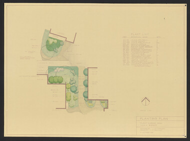 University of Melbourne, Burnley Campus Archives
Plan, Student Amenity Building (Citriodora) Courtyard, 1988-2000
Various plans for what is now known as the "Citriodora Courtyard." I copy tracing paper, 1 coloured original, 4 copies with additional notation 6 smaller copies with additional notation. (1) Planting Plan Plant Science Area V.C.A.H. Burnley designed by J. Hitchmough, drawn by S. Mullany 3 October 1988. (2) Student Amenity Quad Sketch Proposal by M. Green May '95. (3) Rough pencil design, New Design related to Horticultural pursuits of Burnley College. (4) Coloured, Proposed Citriodora Court Redevelopment. (5) 2 copies Citriodora Courtyard Presentation Concept Plan by Adrian Bonifacio. November 2000. (6) Landscape Graphics II Assoc. Diploma in Horticulture (Amenity) Assignment 2 - Planting Plan May 1988. (7) Laminated, Preliminary Plan 2 of 4 Citriodora Lawn Burnley by Kate Szmal B.A.S.H. (8) Laminated, Preliminary Plan Student Amenity Building Courtyard V.C.A.H. Burnley by Caroline Lodge. (9) 1 tracing paper and 1 paper copy University of Melbourne Burnley College Student Amenity Building Courtyard 19.8.99. (10) Setout Plan, Planting Plan & Surface Finishes, Details Courtyard & Entrance, ACM Landscape Architecture: Concrete Paving Topsoil, Mulch - notes. "Phil Tulk," handwritten on reverse. (11) Laminated, V.C.A.H. Preliminary Plan p3 of 5 Project No 1 Student Amenity Building Courtyard by K. Watson 15-8-95. (12) Citriodora Courtyard Redevelopment Concept Plan by Judy Brookes November 2000. 2 copies of Drawing 1 of 2, 1 copy Drawing 2 of 2. (13) Proposed Outdoor Eating Area Student Amenities Block: Scheme 1 pp 2-5 of 5, 16.10.96. Scheme 2 pp 3-5 of 5, 16.10.96. Scheme 8 3 copies p1 of 2, 2 copies p2 of 2, 23.6.97, Paving Types p1 of 1, 30.9.99, handwritten on reverse,"to Phil from Nicki." (14) 2 copies Entry from Rear Car Park Paving Plan. (15) Plan by Margaret Kitching 8.8.90. citriodora courtyard, vcah, centenary courtyard, plant science area, k. watson, s. mullaney, j. hitchmough, judy brookes, kate szmal -
Stawell Historical Society Inc
Plan, A Master Plan for Central Park Stawell, 2000
Grey Cover. Fawn binder a4 SizeMay 2000 Prepared for the Northern Grampians Shire Councilsport, central park, northern grampians shire -
Port Melbourne Historical & Preservation Society
Plan - Annotated and handcoloured by Peter Libbis to indicate his research into Libbis family residences and hotels on copy of a section of an MMBW map, Melbourne and Metropolitan Board of Works, c. 1980s
Peter LIBBIS obtained these copies from the MMBW when he researched his family history in the 1980s. He has annotated them, colour in hotels etc. Donated to Society in 1997.One of a group of 19 photocopies of various 20th century MMBW plans, annotated/coloured in to indicate residences of Libbis family and local hotels, by Peter LIBBIS in family and hotel research - Ross to Clark, Graham to Bridge, date unknownbusiness and traders - hotels, built environment - domestic, transport - railways, melbourne and metropolitan board of works, libbis family, caroline libbis, thomas libbis -
Moorabbin Air Museum
Plan (item) - CAC Wirraway Agricultural Conversion XP.77 Drawing, C.A.C Wirraway Agricultural Conversion XP.77, 02/1957
This schematic was drawn by W. J. Watkins for the Commonwealth Aircraft Corporation during February 1957. It shows the XP-77 experimental conversion of the Wirraway general-purpose military aircraft. This drawing appears to depict the early stages of the CAC's Ceres design, which later had limited success as an agricultural aircraft carrying out tasks such as crop spraying. As the prototype first flew in February 1958, this diagram represents part of the development process for that aircraft. It also demonstrates an important phase in the history of the CAC, where, after the Second World War, the company was innovating in an attempt to stay relevant after the rapid shrinking of the RAAF. -
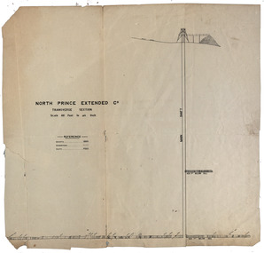 Federation University Historical Collection
Plan, North Prince Extended Co
Transverse section of the North Prince Extended Co,north prince extended, mining company, gold -
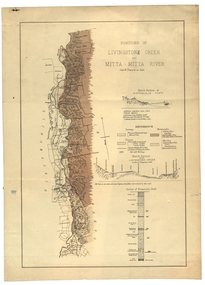 Federation University Historical Collection
Plan, Livinstone Creek and Mitta Mitta River
Plan showing geological eras and soil types. Scale 80 chains to 1 inchmitta mitta, mitta mitta river, hinnomunjie flats, mining, shafts, livingstone creek -
Glenelg Shire Council Cultural Collection
Plan - Plan / Line Drawing Port of Portland Slipway Bilge Blocks, Tug 'Kiama', 05/07/1987
Front: - black texta, top right cornerport of portland -
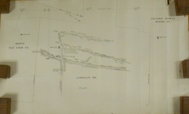 Bendigo Historical Society Inc.
Plan - MARKS COLLECTION: LANSELL'S 180 PLAN, LEVELS 18, 19 AND 20
Plan of underground section of Lansell's 180 mine, levels 18, 19 and 20. On RH side of map Victoria Quartz Mining company claim marked, on LH side North Old Chum Co. 'West or hanging wall' marked above each level.bendigo, mining, lansell's little 180 mine -
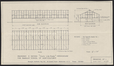 University of Melbourne, Burnley Campus Archives
Plan, Proposed 8 Section "Clark Lite-Frame" Greenhouse, 1965
Plans for new greenhouse by Banyule Australia Pty. Ltd. (1) Drawing No 1 G.W.C. Proposed 8 Section "Clark Lite-Frame" Greenhouse for Burnley School of Horticulture, Plan Side Elevation, End Elevation. (2) Drawing No 2 Typical Glazing Detail, End Corner Detail, Typical Section Thru' Greenhouse. (3) Drawing No 3. Continuous Ridge Ventilator detail. Drawing No. 4. Sliding Door Arrangement. Drawing No 5. Framing Arrangement. Dated 24.10.1965 - 29.10.1965.greenhouse, banyule australia pty. ltd., burnley school of horticulture -
University of Melbourne, Burnley Campus Archives
Plan (Item), Vireya Rhododendrons
vireya rhododendron, burnley gardens -
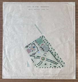 Port Melbourne Historical & Preservation Society
Plan - Edwards Park improvements (Trugo Green), Port Melbourne, 1940s - 1950s
Although undated, this plan is probably from the late 1940s or early 1950s. Around this time Port Melbourne Council were looking to built a basketball court in Lagoon reserve, and shelters and a senior citizen's clubhouse in Edwards Park. PMHPS does to believe the basketball court shown in the plan was built but the Port Melbourne Senior Citizens and Trugo Club is at the location shown on the plan. A shelter is in a similar location to the one on the plan. A children's playground existed in that location shown in a photograph from the 1930s. The round flowerbed where the paths cross in the centre of the park in not in the 1930s photograph but is a current feature of Edwards Park.Plan drawing to scale, hand coloured, of proposed improvements to Edwards Park (Trugo Green), undated possibly late 1940s or early 1950s."City of Port Melbourne"built environment - recreational facilities, parks and gardens, sport - trugo, port melbourne trugo club, edwards park -
Glenelg Shire Council Cultural Collection
Plan - Ship Plan / Mould, n.d
Wooden pattern for mould for boat fitting. Arch shaped, flat base. Smaller arch shaped piece attached to front and back. Centre section shaped narrower at top, small wooden cylinder through centre. Traces of white paint. -
Glenelg Shire Council Cultural Collection
Plan - Plans, n.d
Port of Portland Authorityport of portland archives -
 University of Melbourne, Burnley Campus Archives
Plan, Egg Laying Competition Pens, c. 1957
Plan of layout of the fowl sheds and coops.Handwritten on plan ,"on original 1. plan of existing fence. 2. plan of proposed fence." sheds, coops, egg laying, competitions -
Moorabbin Air Museum
Plan (Item) - Airtrainer CT4 Plans
-
Glenelg Shire Council Cultural Collection
Plan - Ship Plan / Mould, n.d
Wooden pattern for mould for boat fittings. Circular base, circular knob attached to top, painted green. -
 Kew Historical Society Inc
Plan - Subdivision Plan, Erin Heights Estate, East kew, 1917
Pru Sanderson, in her groundbreaking ‘City of Kew Urban Conservation Study : Volume 2 - Development History’ (1988), summarised the periods of urban development and subdivisions of land in Kew. The periods that she identified included 1845-1880, 1880-1893, 1893-1921, 1921-1933, 1933-1943, and Post-War Development. These periods were selected as they represented periods of rapid growth or decline in urban development. An obvious starting point for Sanderson’s groupings involved population growth and the associated economic cycles. These cycles also highlighted urban expansion onto land that was predominantly rural, although in other cases it represented the decline and breakup of large estates. A number of the plans in the Kew Historical Society’s collection can also be found in other collections, such as those of the State Library of Victoria and the Boroondara Library Service. A number are however unique to the collection.The Kew Historical Society collection includes almost 100 subdivision plans pertaining to suburbs of the City of Melbourne. Most of these are of Kew, Kew East or Studley Park, although a smaller number are plans of Camberwell, Deepdene, Balwyn and Hawthorn. It is believed that the majority of the plans were gifted to the Society by persons connected with the real estate firm - J. R. Mathers and McMillan, 136 Cotham Road, Kew. The Plans in the collection are rarely in pristine form, being working plans on which the agent would write notes and record lots sold and the prices of these. The subdivision plans are historically significant examples of the growth of urban Melbourne from the beginning of the 20th Century up until the 1980s. A number of the plans are double-sided and often include a photograph on the reverse. A number of the latter are by noted photographers such as J.E. Barnes.The Erin Heights Estate in Kew included just seven lots in in Valerie Street. These were all that remained of this wartime subdivision, the other 11 allotments on Balfour and Belford Roads having already been sold. Balfour Road was to be only a temporary name as the street is currently called Windella Avenue. Now, the parkland opposite the subdivision is the reserve created from the route of the Outer Circle Railway. This Railway reached Kew East in 1925, but had been planned as far back as 1873. The development focuses on the benefits of living in Kew: being at the highest of Kew’s ‘suburbs’; being a good residential area; its rapid growth; and the proximity of the Kew East tram in High Street. In 1917, the electric tramline only extended to a terminus at the Harp of Erin hotel. The terminus is clearly represented on the plan.subdivision plans - east kew, erin heights estate -
Moorabbin Air Museum
Plan (item) - Bristol Aeroplane 170 schematic drawings, Bush - Piston
Bristol Aeroplane Company Ltd -
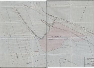 Bendigo Historical Society Inc.
Plan - MCCOLL, RANKIN AND STANISTREET COLLECTION: PLAN OF MONUMENT HILL BATTERY
Pale blue waxed paper plan. Written on back of plan ' Monument Hill Battery site, area desired by Bendigo Mines (Nell Gwynne) for disposal of mullock. Plan shows Ophir Street, Rowan Street, Written on bottom RH corner 'Bendigo Mines Ltd., surface plan, vicinity Nell Gwynne Shaft, Scale 1" = 40' Magnetic north marked, sand dumps and contour lines.bendigo, business, mccoll, rankin & stanistreet -
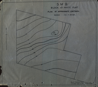 Federation University Historical Collection
Plan, SMB Block at White Flat
Plan of contours at White Flat, Ballarat Central. white flat, ballarat school of mines, ballarat central -
Glenelg Shire Council Cultural Collection
Plan - Town Plan - Cape Bridgewater, 02/04/1992
Black and white photocopy of an old plan of a subdivision at Cape Bridgewater. Two halves joined together with sellotape. Black texta numbers on some of the lots 1 - 28Front: 'OLD MAP' handwritten, top edgeplan, town planning, cape bridgewater -
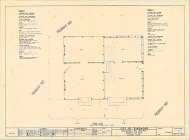 Ringwood and District Historical Society
Plan - Ringwood Lake Reserve Miners Cottage - 1983, Preliminary Building Plans - 3 Sheets. Floor Plan, Elevation, Sectional Views and Details
Sheets 1, 2 & 3 - Construction of replica miners cottage at Ringwood Lake Reserve, opened May, 1983.Preliminary Only