Showing 1648 items in the category Documentation with item type Plan
-
 Moorabbin Air Museum
Plan (item) - Bristol Aeroplane 170 schematic drawings, Fuse Chart Mk XXI
Bristol Aeroplane Company Ltd -
Moorabbin Air Museum
Plan (Item) - Plan SIAI Marchetti S211 Ex GAF
-
 Federation University Historical Collection
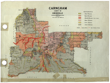
Plan, Carngham, County of Grenville
A plan of Carngham, Victoria.snake valley, timber reserve, poverty point, recreation reserve, carngham, county of ripon, county of grenville, plan -
Port Melbourne Historical & Preservation Society
Plan, John James Wild, Architect, New Town Hall Sandridge 1881, 1 Jan 1881
Laminated copy from City collection, elevation plans for new Town Hall Sandridge 1881. .01 - front elevation .02 - rear elevation .03 - transverse section .04 - ground floor plan - A3 copy .05 - first floor plan - A3 copyarchitecture, port melbourne town hall, town clerks, built environment - civic, sandridge town hall, john james wild, edward clark -
Glenelg Shire Council Cultural Collection
Plan - Plan - S.S Admella Model Plans, SS 'Admella', n.d
Photocopy of model plan for lines and general arrangement of SS 'Admella'. scale 1:48. Photocopy paper is parchment style. Plan used by 'Float-a-boat' model makers for the construction of the Admella model acquired by Grant District council. -
University of Melbourne, Burnley Campus Archives
Plan, Burnley Gardens Site Works, 1961
Coloured plan by Public Works Department, Chief Engineers Branch. Burnley Gardens, Site Works No 61.263. Drawn and traced by W. Walker Engineer, dated 30.05.1961. Folded to fit into boxburnley gardens, buildings, public works department, w. walker -
 Kew Historical Society Inc
Plan - Subdivision Plan, Kew Golf Links Estate, 1936, 1936
The Kew Golf Links Estate was a major subdivision in North Kew. It derived its title due to the land being previously occupied by the Kew Golf Club, which transferred its course to a number of locations before occupying its current site. The Plan advertises 180 choice home sites. The street names are somewhat different today as those on the map are named after the proposed Kodak Factory to be built on the site. The subdivision of the Kew Golf Links Estate was a major subdivision of farmland in Kew. The site was at one stage designated for industrial development and the building of a new Kodak factory. The decision by Council to oppose the redevelopment makes the beginning of the period when all industrial development was banned in Kew.Monochrome printed, folded subdivision plan for the Kew Golf Links Estate, to be auctioned on 7 November 1936. Streets named include: Carnegie Avenue, Willsmere Road, Kilby Boulevarde, Kodak Avenue, Coleman Avenue, Beresford Avenue, McConchie Avenue, Cole Avenue, White Avenue, Baker Avenue, Spruzen Avenue, Tanner Avenue, Ratten Avenue, Mathers Avenue, Railway Avenue, Sutherland Avenue, and Belford Road. The position of the Yarra River and a large Drainage Reserve are marked on the plan. Lots for sale are numbered. Existing buildings are designated with a square.subdivision plans - kew (vic), kodak factory - kew (vic) -
Glenelg Shire Council Cultural Collection
Plan - Glenelg Shire Council Plan 2004-2008, c. 2004
Glenelg Shire Council Plan 2004-2008. -
Glenelg Shire Council Cultural Collection
Plan - Plan - Port of Portland Authority Slipway, Fishing Vessel 'Enterprise', 29/10/2010
Front: '19' - black texta, top right cornerport of portland -
University of Melbourne, Burnley Campus Archives
Plan, Re-organisation of Apple Block, 1956
Plan dated June 1956orchards, fruits, apples -
University of Melbourne, Burnley Campus Archives
Plan, Plan showing proposed adjustment of boundaries of the Horticultural Society's Gardens in Richmond Park, c.1880-1884
Copy of B92.0535 framed and glazed.gardens, richmond, hoticultural society of victoria, river yarra -
Glen Eira Historical Society
Plan - Nettalie
Land Victoria title documents vol 339 folio 763A and 764 relating to the property Nettalie on the corner of Balaclava and Orrong Rds. These documents detail the history of the land dealing relating to Nettalie and the neighbouring estate Harleston listed as parcels 209a and 209b. These dealing include grants of land, mortgages and conveyance (transfers). The documents include photocopies of handwritten notes of the title history date 1870; a partial copy of an instrument of conveyance dated 1863 and the original titles of the land owned at various times by William Noall, Alfred Shaw, Alfred Desailly and Sir Frederick Grimwade. Within the documents are various hand drawn and printed diagrams of the subdivisions.forsyth william, noall william, cutts william henry, shaw alfred, hailes george button, bakewell john, pascoe john randle, little william, fraser alexander, powell walter, whitney john, hodgeson richard, trollope william thomas, keep edward, blundell mary, carr john bonney, farie claud, fosberry john wallcott, davies john, brady michael, lloyd frederick, turner george, desailly alfred, grimwade frederick s sir, parish of prahran, county of bourke, caulfield north, st kilda east, balaclava road, orrong road, nettalie, netley house, harleston, melbourne grammar school, land subdivision, land sales, land titles, legal documents, homestead, schools, houses -
 Federation University Historical Collection
Plan - Plans, Plan of the Ballarat Gaol
Copies of plans of Ballarat Gaol. One has later Ballarat School of Mines buildings drawn onto a plan. ballarat gaol, ballarat school of mines library, e.j. tippett library, learning resource centre, ballarat supreme court, governor's residence, domestic arts, dressmaking -
University of Melbourne, Burnley Campus Archives
Plan, Overall Plans VACH
nursery, site plan, field station -
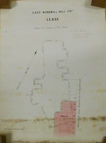 Bendigo Historical Society Inc.
Plan - MARKS COLLECTION: EAST WINDMILL HILL CO LEASE PLAN
Plan on heavy paper. On top of plan ' East Windmill Hill Coy's Lease, scale one inch to one chain' Signed in ink by Thomas McNulty (?) Mining Engineer. On RH side of plan written 'Main Road from Sandhurst to Eaglehawk'.bendigo, mining, east windmill hill lease co -
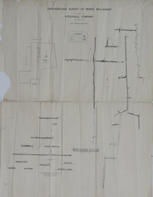 Federation University Historical Collection
Plan, Underground Survey of Mines, Ballaarat, not dated
Printed transverse section of the Speedwell Company.underground survey, speedwell company -
University of Melbourne, Burnley Campus Archives
Plan (Item) - Landscape design, Landscape Design Plant List & Graphic interpretation - For?
amy willis, landscape design -
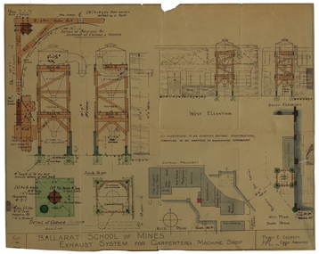 Federation University Historical Collection
Plan - Architectural Drawing, Ballarat School of Mines: Exhaust System for Carpenter's Machine Shop, 1948, 1948
Lined drawing with coloured sections. Measurements: imperial Labelling of each section Name and initials of Chief Architect, Percy Everettelevation, ballarat school of mines, percy everett, exhaust system, plan -
Moorabbin Air Museum
Plan (item) - C.A.C Turbojet Trainer A.S Viper XPO.57. P266
-
University of Melbourne, Burnley Campus Archives
Plan, Base Plan Residential Landscape, 1994
2 plans on tracing paper dated 17.03.1994 and 23.03.1994. Same site, different anotation. Scale 1:100. Drawn by J.K.landscape design, residential -
University of Melbourne, Burnley Campus Archives
Plan, Ian Robertson, Student Gardens Burnley Campus, 1989
Plans on tracing paper by Ian Robertson. Scale 1:50. 1. Planting Plan, Sheet No 5, 19.5.89. 2. Master Plan, Sheet No 6, 6.6.89. 3. Preliminary Plan Sheet No 4, 19.5.89.ian robertson, burnley campus, student gardens -
University of Melbourne, Burnley Campus Archives
Plan, Jordan Hansen, David Aldous Turf Memorial Garden Landscape Concept Plan, 2016
Landscape Concept Plan designed by Jordan Hansen for Andrew Smith LCP-001 David Aldous Turf memorial Garden 2016 - page 18. Scale 1:100andrew smith, jordan hansen, landscape design -
 Kew Historical Society Inc
Plan - Subdivision Plan, Lodged Plan No.6518, 1920-1940
The Kew Historical Society collection includes almost 100 subdivision plans pertaining to suburbs of the City of Melbourne. Most of these are of Kew, Kew East or Studley Park, although a smaller number are plans of Camberwell, Deepdene, Balwyn and Hawthorn. It is believed that the majority of the plans were gifted to the Society by persons connected with the real estate firm - J. R. Mathers and McMillan, 136 Cotham Road, Kew. The Plans in the collection are rarely in pristine form, being working plans on which the agent would write notes and record lots sold and the prices of these. The subdivision plans are historically significant examples of the growth of urban Melbourne from the beginning of the 20th Century up until the 1980s. A number of the plans are double-sided and often include a photograph on the reverse. Reconciling this hand-drawn subdivision plan with a modern map of the area is initially a challenge due to a change of street names. Argyle Road in the centre of the subdivision was to be renamed Deepdene Road, and the street named Deepdene Road on the plan was to become Deepdene Place. Of interest is the nursery on the corner of Argyle and Whitehorse Roads. During this period there were a number of nurseries servicing the Kew and Balwyn areas. The subdivision was essentially of the land formerly occupied by the house 'Deepdene'.subdivision plans - balwyn, deepdene, whitehorse road -- deepdene (vic.), deepdene road -- deepdene (vic.), burke road -- deepdene (vic.) -
Moorabbin Air Museum
Plan (Item) - BAE Paper Hawk Aeroplane Plans
-
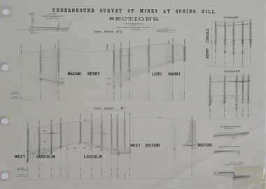 Federation University Historical Collection
Plan, Underground Survey of Mines at Spring Hill Cross Section No 2, 1886
Plan printed by the Government Printing Office Melbourne, of underground survey at Spring Hill.underground survey, spring hill, steam litho government printing office -
Moorabbin Air Museum
Plan (Item) - CAC plans include CA25 Sopwith Hawker Hurricane fuel injection system Fyling controls AA 107 CA31 Mustang, CAC various aircraft plans
-
 Kew Historical Society Inc
Plan, Melbourne & Metropolitan Board of Works : Borough of Kew : Detail Plan No.1572, 1905
The Melbourne and Metropolitan Board of Works (MMBW) plans were produced from the 1890s to the 1950s. They were crucial to the design and development of Melbourne's sewerage and drainage system. The plans, at a scale of 40 feet to 1 inch (1:480), provide a detailed historical record of Melbourne streetscapes and environmental features. Each plan covers one or two street blocks (roughly six streets), showing details of buildings, including garden layouts and ownership boundaries, and features such as laneways, drains, bridges, parks, municipal boundaries and other prominent landmarks as they existed at the time each plan was produced. (Source: State Library of Victoria)This plan forms part of a large group of MMBW plans and maps that was donated to the Society by the Mr Poulter, City Engineer of the City of Kew in 1989. Within this collection, thirty-five hand-coloured plans, backed with linen, are of statewide significance as they include annotations that provide details of construction materials used in buildings in the first decade of the 20th century as well as additional information about land ownership and usage. The copies in the Public Record Office Victoria and the State Library of Victoria are monochrome versions which do not denote building materials so that the maps in this collection are invaluable and unique tools for researchers and heritage consultants. A number of the plans are not held in the collection of the State Library of Victoria so they have the additional attribute of rarity.Original survey plan, issued by the MMBW to a contractor with responsibility for constructing sewers in the area identified on the plan within the Borough of Kew. The plan was at some stage hand-coloured, possibly by the contractor, but more likely by officers working in the Engineering Department of the Borough and later Town, then City of Kew. The hand-coloured sections of buildings on the plan were used to denote masonry or brick constructions (pink), weatherboard constructions (yellow), and public buildings (grey). Plan No. 1572 represents the built environment bordered by Barkers Road, Wrixon Street, Edgevale Road and Fitzwilliam Street. Other streets identified on the plan include Stansell Street. Plan 1572 shows that by 1903-05, there was only patchy development in this area of Kew, mainly on Edgevale Road and Fitzwilliam Street. Only two named houses are identified: the quaintly named ‘Tweed Cottage’, and ‘Mendip’. The earliest reference to Treed Cottage in Australian newspapers is to the death of Walter Thompson, aged 74 who was a resident there in 1885. His youngest daughter was to die there in 1908. Mendip to the north of Tweed Cottage was owned by Henry Thompson; he was to die in 1901; his wife in 1932. At this period of time, Malin Street and Clivedon Court did not extend to Barkers Road.melbourne and metropolitan board of works, detail plans, mmbw 1572, cartography -
 Kew Historical Society Inc
Plan - Subdivision Plan, Mont Victor Hill Estate, 1936
Pru Sanderson, in her groundbreaking ‘City of Kew Urban Conservation Study : Volume 2 - Development History’ (1988), summarised the periods of urban development and subdivisions of land in Kew. The periods that she identified included 1845-1880, 1880-1893, 1893-1921, 1921-1933, 1933-1943, and Post-War Development. These periods were selected as they represented periods of rapid growth or decline in urban development. An obvious starting point for Sanderson’s groupings involved population growth and the associated economic cycles. These cycles also highlighted urban expansion onto land that was predominantly rural, although in other cases it represented the decline and breakup of large estates. A number of the plans in the Kew Historical Society’s collection can also be found in other collections, such as those of the State Library of Victoria and the Boroondara Library Service. A number are however unique to the collection.Subdivision plans are historically important documents used as evidence of the growth of suburbs in Australia. They frequently provide information about when the land was sold on which a built structure was subsequently constructed as well as evidence relating to surveyors and real estate and financial agents. The numerous subdivision plans in the Kew Historical Society's collection represent working documents, ranging from the initial sketches made in planning a subdivision to printed plans on which auctioneers or agents listed the prices for which individual lots were sold. In a number of cases, the reverse of a subdivision plan in the collection includes a photograph of a house that was also for sale by the agent. These photographs provide significant heritage information relating house design and decoration, fencing and household gardens.A preliminary plan for the Mont Victor Hill subdivision of 1936 which included 23 allotments bordering the Rimington Nursery in Mont Victor Road. The subdivision created allotments in Victor Avenue, Heather Grove and Burke Road. Bisecting the Estate and clearly marked on the plan is the Railway Reserve which at this stage was all that remained of the Outer Circle Railway. The auctioneers note on the plan that the subdivision was made possible by the order of Messrs S. H. Bennet & H. Wright, the executors of the Wills of S. Bennett & E. Foreman.mont victor hill estate, subdivision plans - kew -
 Kew Historical Society Inc
Plan - Subdivision Plan, Eastlawn Estate, 1914
Subdivision plans are historically important documents used as evidence of the growth of suburbs in Australia. They frequently provide information about when the land was sold on which a built structure was subsequently constructed as well as evidence relating to surveyors and real estate and financial agents. The numerous subdivision plans in the Kew Historical Society's collection represent working documents, ranging from the initial sketches made in planning a subdivision to printed plans on which auctioneers or agents listed the prices for which individual lots were sold. In a number of cases, the reverse of a subdivision plan in the collection includes a photograph of a house that was also for sale by the agent. These photographs provide significant heritage information relating house design and decoration, fencing and household gardens.The ‘Eastlawn Estate’ was surveyed and ready for auction in March 1914, three months before the outbreak of World War I. Sixty-six allotments, created on the ‘order of Mr & Miss Preston’ surrounded the mansion of Woodlands in Harp Road. Woodlands formed part of the Estate, being advertised as lot 1. The allotments faced High, Station and Wright Streets, Harp and Normanby Roads, and Woodlands Avenue. Pru Sanderson in the Kew Conservation Study (Vol.2, 1988) wrote that the Eastlawn Estate ‘covered the western half of the failed Harp of Erin Estate’. Contemporary advertisements promoted the Eastlawn Estate as: ‘There will be no more convenient district nor pleasant Suburb than East Kew for the busy business man. When the Electric Tram is laid, he will be able to journey quickly and pleasantly direct from Collins Street to his home in the Eastlawn Estate in about 20 minutes’. The actual plans of subdivision were included in advertisements in The Argus and in the local newspapers.subdivision plans - east kew, eastlawn estate -
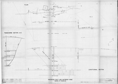 Ringwood and District Historical Society
Plan - Department of Mines, Victoria, Ringwood Gold and Antimony Mine - 1921
Technical drawings of Antimony Mine - Plan view, Transverse Section view, and Longitudinal Section view. Includes Main Shaft, No.1 Level 184', No.2 Level 244', No.3 Level 304', No.4 Level 372'. Multiple copies, including copy with overlay of Civic Centre.Scale 40 feet to 1 inch. Surveyed 20-12-21. Traced 1-7-66. W-2568/B/1.