Showing 1653 items in the category Documentation with item type Plan
-
 University of Melbourne, Burnley Campus Archives
Plan, Plan of Creswick Park - Hawthorn, c. 1970
2 Photocopies of plan showing irrigation lines. No 885.creswick park, hawthorn, webb-way irrigation system -
University of Melbourne, Burnley Campus Archives
Plan, Native Garden V.C.A.H Burnley Native Garden area, 1990-2015
Placement and heights of 5 trees, Burnley Native Garden Area 9/11/90. Includes placement and heights of 5 feature trees, Kath Deery Native Garden. Also notes by Geoff Olive made 16.05.2015 from recollections.native garden, kath deery, geoff olive, vcah burnley -
 City of Moorabbin Historical Society (Operating the Box Cottage Museum)
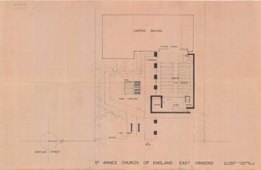
Plan - Extension Plans for St.Anne's Church of England, Moylan Street, East Ormond
St Anne's Church of England in Moylan Street, East Ormond was closed in 1995. These plans were drawn up to add an extension to the existing church - but it was never built.Example of the progress of the Municipality of MoorabbinArchitectural Drawings for St Annes Church of England East Ormond - proposed plans for extension 2 pagesst anne's church of england, moylan street, east ormond, religion, building plans -
University of Melbourne, Burnley Campus Archives
Plan, Paul Green, Camellia Garden, 1985
Sketch on tracing paper by Paul Green. Job No 1, dated 15.09.1985.paul green, gardens, camellia -
 Kew Historical Society Inc
Plan - Subdivision Plan, Belford Heights Estate, Kew, ca. 1925
Pru Sanderson, in her groundbreaking ‘City of Kew Urban Conservation Study : Volume 2 - Development History’ (1988), summarised the periods of urban development and subdivisions of land in Kew. The periods that she identified included 1845-1880, 1880-1893, 1893-1921, 1921-1933, 1933-1943, and Post-War Development. These periods were selected as they represented periods of rapid growth or decline in urban development. An obvious starting point for Sanderson’s groupings involved population growth and the associated economic cycles. These cycles also highlighted urban expansion onto land that was predominantly rural, although in other cases it represented the decline and breakup of large estates. A number of the plans in the Kew Historical Society’s collection can also be found in other collections, such as those of the State Library of Victoria and the Boroondara Library Service. A number are however unique to the collection.The Kew Historical Society collection includes almost 100 subdivision plans pertaining to suburbs of the City of Melbourne. Most of these are of Kew, Kew East or Studley Park, although a smaller number are plans of Camberwell, Deepdene, Balwyn and Hawthorn. It is believed that the majority of the plans were gifted to the Society by persons connected with the real estate firm - J. R. Mathers and McMillan, 136 Cotham Road, Kew. The Plans in the collection are rarely in pristine form, being working plans on which the agent would write notes and record lots sold and the prices of these. The subdivision plans are historically significant examples of the growth of urban Melbourne from the beginning of the 20th Century up until the 1980s. A number of the plans are double-sided and often include a photograph on the reverse. A number of the latter are by noted photographers such as J.E. Barnes.The Belford Heights Estate was a subdivision in Kew East, even though the title of the plan indicates that it was located in Kew. The subdivision had been approved by 1915, and included 105 lots facing Strathalbyn, Kitchener, Hamilton and Beresford Streets, as well as Balfour and Belford Roads. Those lots hand coloured with red probably represent blocks that had been sold. The additional information provided on the plan is also of interest. The plan includes the original location of East Kew State (Primary) School in Strathalbyn Street, which opened in 1892. The inset Locality Plan also includes the route of the Outer Circle Railway and the location of the Wilsmere and East Kew Stations. The location of the landmark Harp of Erin Hotel is also marked on the Locality Plan.belford heights estate, subdivision plans - kew -
Glenelg Shire Council Cultural Collection
Plan - Plan / line drawing of a steel tuna vessel, c. 1978
Port of PortlandFront: '12'- black texta, top right cornerport of portland -
University of Melbourne, Burnley Campus Archives
Plan, ACM Landscape Architecture, Courtyard & Entrance, 1995
Photocopies of sketches of Set out plan, Planting plan & surface finishes details. Typed description of works by ACM Landscape Architecture. Not sure if this relates to Burnley or is Student work.acm landscape architecture, burnley, courtyard garden -
 Federation University Historical Collection
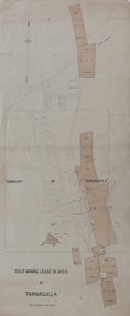
Plan, Gold Mining Lease Blocks at Tarnagulla, not dated
Printed plan with red shading showing gold mining lease blocks at Tarnagullaplan, mining leases, gold mining, tarnagulla, mining -
Moorabbin Air Museum
Plan (item) - Bristol Aeroplane 170 schematic drawings, Assy. of Web Doubler- Rear Spar
Bristol Aeroplane Company Ltd -
 Ringwood and District Historical Society
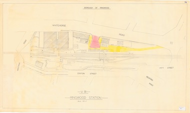
Plan, Borough of Ringwood - VR Ringwood Station - Circa 1930s
Technical drawing of Ringwood Railway Station features, surrounding streets and buildings including Cool Stores, Packing Shed, Coke Bin, Coal Box, Dam, Garage, Shops, ES&A Bank, Station Master's Residence, Drill Hall, Goods Shed, Signal Box, Passenger Platform, Footbridge, and Clock Tower at Warrandyte Road. Station entrance and traffic access areas shaded red and yellow.Scale: 1"=40' -
 Federation University Historical Collection
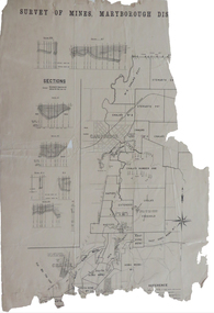
Plan, Survey of Mines, Maryborough District, not dated
Maryborough is a Central Victorian town. Printed section of the Maryborough Districtmaryborough, carisbrook, majorca, horizontal sections, vertical sections, chalk's no 4, east kong meng, craigie -
University of Melbourne, Burnley Campus Archives
Plan, AMRAD Burnley Development Civil Drawings, 1997-1998
Job No 74046 New Laboratories & Offices Building 5 & 9 AMRAD Burnley Development, for AMRAD Operations Pty. Ltd. By Scott Wilson Irwin Johnston. (1) C1 Drawing Index, Legend & General Notes, Nov 97. (2) C2 Pavement & Drainage Plan 03.98. (3) C3 Pit Schedule & Pavement Details 03.98.scott wilson irwin johnston, amrad, johnston merat kurdiovsky architects, amrad burnley development -
University of Melbourne, Burnley Campus Archives
Plan, Water Supply, c. 1960
A. Plan of existing and proposed new buildings, temporary structures or due for demolition. Water Supply Plan sketched over. B. Sketch plan on tracing paper, further details of water supply.water suplly -
Glenelg Shire Council Cultural Collection
Plan - Ship Plan/ Mould, n.d
Wooden pattern for mould for boat fitting. Rod with U-shape at one end. Cylinder attached to both arms of U-shape, thru the centre. Painted orange/yellow. -
Moorabbin Air Museum
Plan (item) - C.A.C Details Of Receiver End Connections Refrigeration Circuit Details Sheet 2
-
 Flagstaff Hill Maritime Museum and Village
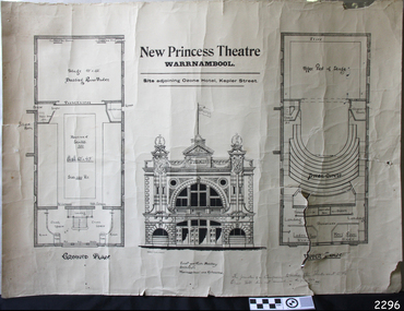
Plan
Plan Architects of the New Princess Theatre, Kepler Street, Warrnambool, also the prospectus of the Princess Theatre Company.flagstaff hill, warrnambool, shipwrecked-coast, flagstaff-hill, flagstaff-hill-maritime-museum, maritime-museum, shipwreck-coast, flagstaff-hill-maritime-village, princess theatre, kepler street, princess theatre company -
Moorabbin Air Museum
Plan (Item) - Drawing Exterior Emergency Markings - Inboard & Outboard Nacelles Orion P3-B Aircraft Drawing A16194 Sheet 5 Of 5 Sheets
-
 Kew Historical Society Inc
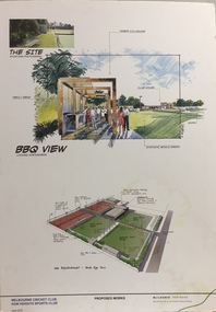
Plan - Architectural Sketch, MCC Kew Sports Club Proposed Works BBQ View, 2012
Sports Clubs in Kew in the final decades of the 19th century and in the early 20th century were often umbrella organisations with facilities for a number of sports. Typically in Kew, this included teams in lawn bowls, tennis and croquet. The Kew Bowling Club was formed in 1880 while the privately owned Auburn Heights Recreation Club was opened in 1904. By 1998, the two Clubs decided to amalgamate at the Auburn Heights site in Barkers Road, forming the Kew Heights Sports Club. The combined club was itself taken over by the Melbourne Cricket Club in 2012 becoming MCC Kew Sports Club. In 2017 MCC Kew closed and its landholding was subsequently sold to Carey Baptist Grammar School. Both the Kew and Auburn Heights Clubs assembled important collections. These historically significant and large collections were donated to the Society in 2020. The collections include manuscripts, pictures, trophies, plans, honour boards etc. The combined collections of the four sporting clubs making up the collection number hundreds of items that are historically significant locally. They are also significant to the sporting history of the greater Melbourne area and to the sports of lawn bowls and tennis in Australia in the 19th and 20th centuries. The collection illuminates two of the Victorian historic themes - 'Building community life' through forming community organisations and 'Shaping cultural and creative life' by participating in sport and recreation.Architectural sketches on corflute of proposed designs for the new MCC Kew Sports Club by McIldowie Partners (Architects & Interior Designers), 2012.mcc kew sports club - barkers road - kew (vic), mcildowie partners -- architects, architectural sketches -
University of Melbourne, Burnley Campus Archives
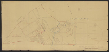
Plan, School of Primary Agriculture & Horticulture - Burnley, c. 1925-1926
Copy of plan photographed at the Public Records Office Victoria. Central Administration Correspondence Files 1912-1939 ITEM. VPRS 10163/P0003/2. Accomodation Burnley School Part 1. Traced from M.M.B.W. Plan No. 42. Scale 160 ft=1 in. Level Datum L.M.N. Hobson's Bay. Traced by C.E.B.W. 16.02.1926. Additional matter in red and green inserted by F.E.T.C. 09.02.1926. Note by J.J. Rae (Principal). Lists W.C.s (toilets). Shows 1891 Flood Line. Possibly dates from 1925.prov, school of primary agriculture and horticulture, burnely, j.j. rae -
Glenelg Shire Council Cultural Collection
Plan - Plans - Port of Portland Slipway - Steel Trawler 'Aqua Enterprise', 02/10/1980
PORT OF PORTLAND AUTHORITYFront: '18' - black texta, top right corner -
 University of Melbourne, Burnley Campus Archives
Plan, Burnley Layout: Security Fencing, 1948-1949
Copy of plan by L.H.B. of proposed new buildings, extensions and other works. Exisiting permanent buildings and those due for demolition. Second plan with sketch over showing proposed area for plant breeding, pasture, nursery, new fencing. Indication of building damaged by fire 19.12.1949.burnley school of horticulture, extensions, buildings, demolition, nursery -
 Queenscliffe Maritime Museum
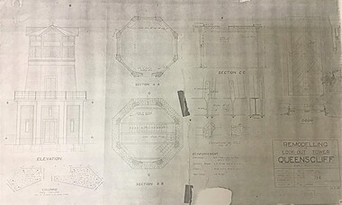
Plan - Plan for a Signal Station Look-out Tower Queenscliff
A plan for the remodelling of the look-out tower at Queenscliff dated 26 April1938Plan for the the remodelling of the look-out tower at Queenscliff dated 1938plan, queenscliff, signal station, look out tower -
Port Melbourne Historical & Preservation Society
Plan - Port Melbourne Town Hall, Port Melbourne City Council, 1916
Plan for town hall - Details of balustrade to blocking course above main cornice, 1918.port melbourne town hall -
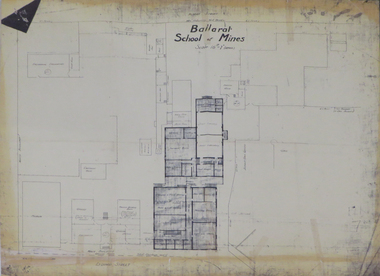 Federation University Historical Collection
Plan, Ballarat School of Mines 'Old Chemistry Building' Plan
Ballarat School of Mines is a predecessor institution of Federation University Australia. Two plans showing the Ballarat School of Mines Old chemistry Building and the Ballarat Technical Art School Building. It also shows the location of the Ballarat School of Mines Model Mine, Battery House, etc.ballarat school of mines, model mine, battery, old chemistry building, ballarat technical art school, laboratory, plan, architectural plans -
University of Melbourne, Burnley Campus Archives
Plan, Proposed BIH Enclosure Rear S.A.B. V.C.A.H. Burnley, c. 1980
Plan on tracing papervcah, burnley -
 University of Melbourne, Burnley Campus Archives
Plan, Burnley School of Agriculture Proposed Drainage Area Plan Shewing (sic) Sections, 1930
From A.W Jessep file "Improvements (Completed)"Hand drawn. (1) Includes Memorandum dated 25.7.30 to the Agricultural Superintendent from the Principal. (2) Levels over Proposed Drainage Area. From A.W. Jessep file, "Improvements (Completed)." Additional memorandum from the Agricultural Superintendent to Principal (1 folio page)burnley school of agriculture, drainage, drainage pipes -
Glenelg Shire Council Cultural Collection
Plan - Ship Plan / Mould, n.d
Wooden pattern for mould for boat fitting. Tear drop shaped piece, sides concave, circular hole in centre. Painted white. -
University of Melbourne, Burnley Campus Archives
Plan, New School of Primary Agriculture & Horticulture Burnley Gardens, 1945
Photocopy of Plan of the Administration Building by the Chief Architect dated 26.9.45. Scale 1/8 inch - 1 foot. Photocopy reduced in size from original. (1) Ground Floor and First Floor Plans. (2) West Elevation, Longitudinal Section 'B-B' and East Front Elevation. (3) Flat Roof, Library and Herbarium. (4) Common Room and Assembly Hall. Originally in the Burnley Archives. Property and Service now have the original and gave the reduced size photocopy to the Archives. Hard to read now.burnley gardens, school of primary agriculture and horticulture -
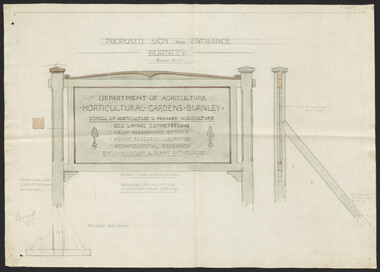 University of Melbourne, Burnley Campus Archives
Plan, Proposed Sign for Entrance to Burnley, 1931
(1) Correspondence between Mr Zevan (Government Cool Stores), the Agricultural Superintendent, R. Crowe (Exports Superintendent) and A.W. Jessep re design for new entrance gates at Burnley Gardens, between 31.03.1931 and 09.07.1931. Invoice from signwriter (A. Clegg). (2) Pencil sketch of proposed design with annotations. (3) Coloured drawing to scale.On verso of drawing: "Gate sign & Watering plans" and "File State Public Works"a.w. jessep, burnley gardens, f. zeven, signs, victoria. department of agriculture -
Glenelg Shire Council Cultural Collection
Plan - Plans/ line drawings of the layout plan for the Trawler Wharf at Port of Portland, 11/09/1988
Port of Portland layout plans for the Trawler Wharf development.Front: '2' - black texta, top right cornerport of portland