Showing 1652 items in the category Documentation with item type Plan
-
 University of Melbourne, Burnley Campus Archives
Plan (Item) - Burnley Gardens, Map 2. Existing Conditions
Annotations in ink and pencil on 1 copy of 5 -
University of Melbourne, Burnley Campus Archives
Plan, Nicole Faulkner, Rose Garden 'Banyule', 1989
Planting Plan for 'Banyule', 72 Buckingham Drive, Heidelberg by Nicole Faulkner for Grad. Dip. Horticulture. Sheet 4 of 4, dated November 1989. Scale 1:100.rose garden, nicole faulkner, "banyule", heidelberg -
 Kew Historical Society Inc
Plan - Subdivision Plan, Pointed Firs Estate, 1936
The Kew Historical Society collection includes almost 100 subdivision plans pertaining to suburbs of the City of Melbourne. Most of these are of Kew, Kew East or Studley Park, although a smaller number are plans of Camberwell, Deepdene, Balwyn and Hawthorn. It is believed that the majority of the plans were gifted to the Society by persons connected with the real estate firm - J. R. Mathers and McMillan, 136 Cotham Road, Kew. The Plans in the collection are rarely in pristine form, being working plans on which the agent would write notes and record lots sold and the prices of these. The subdivision plans are historically significant examples of the growth of urban Melbourne from the beginning of the 20th Century up until the 1980s. A number of the plans are double-sided and often include a photograph on the reverse. A number of the latter are by noted photographers such as J.E. Barnes.An almost identical plan of the ‘Pointed Firs Estate’ is in the State Library of Victoria. The plan unusually uses a photograph to show the panoramic views from the Estate. A prospective purchaser could expect to look across the Yarra Valley to Eaglemont and Heidelberg. The 36 lots advertised for sale faced Doncaster Road, Houghton Street, Maud Street and Thackray Street in Balwyn North.subdivision plans - balwyn, pointed firs estate -
Bialik College
Plan (item) - Proposed Bialik College and extensions, c. 1980s
Architectural plans for Bialik College, 429 Auburn Road, Hawthorn East, created by architects Peter G Lyall & Associates and Joshua and Mary Pila, c. 1980s. Please contact [email protected] to request access to this record.1980s, building and planning -
 Kew Historical Society Inc
Plan, Melbourne & Metropolitan Board of Works : Borough of Kew : Detail Plan No.1565, 1905
The Melbourne and Metropolitan Board of Works (MMBW) plans were produced from the 1890s to the 1950s. They were crucial to the design and development of Melbourne's sewerage and drainage system. The plans, at a scale of 40 feet to 1 inch (1:480), provide a detailed historical record of Melbourne streetscapes and environmental features. Each plan covers one or two street blocks (roughly six streets), showing details of buildings, including garden layouts and ownership boundaries, and features such as laneways, drains, bridges, parks, municipal boundaries and other prominent landmarks as they existed at the time each plan was produced. (Source: State Library of Victoria). This plan forms part of a large group of MMBW plans and maps that was donated to the Society by the Mr Poulter, City Engineer of the City of Kew in 1989. Within this collection, thirty-five hand-coloured plans, backed with linen, are of statewide significance as they include annotations that provide details of construction materials used in buildings in the first decade of the 20th century as well as additional information about land ownership and usage. The copies in the Public Record Office Victoria and the State Library of Victoria are monochrome versions which do not denote building materials so that the maps in this collection are invaluable and unique tools for researchers and heritage consultants. A number of the plans are not held in the collection of the State Library of Victoria so they have the additional attribute of rarity.Original survey plan, issued by the MMBW to a contractor with responsibility for constructing sewers in the area identified on the plan within the Borough of Kew. The plan was at some stage hand-coloured, possibly by the contractor, but more likely by officers working in the Engineering Department of the Borough and later Town, then City of Kew. The hand-coloured sections of buildings on the plan were used to denote masonry or brick constructions (pink), weatherboard constructions (yellow), and public buildings (grey). MMBW Plan No.1565 is an example of a plan where a number of streets have been created since the area was surveyed, or in other cases renamed. The plan shows those streets that were bordered by Ross Street, Mount Street, Sackville Street and Burke Road. Since 1905, Mawson Street has been created and Mont Albert Road renamed as Dean Street. Named houses on the plan include ‘Tyrol’, ‘Glengorse’, ‘Theodore Villa’, ‘Arncliffe’, ‘Ballynira’ and ‘Hazeldene’. The plan also shows a Wesleyan Church in Sackville Street. In 1883, the Church’s Sunday School celebrated its silver anniversary.melbourne and metropolitan board of works, detail plans, mmbw 1565, cartography -
Glenelg Shire Council Cultural Collection
Plan - Ship Plan /Mould, n.d
Wooden pattern for mould for boat fitting. Half cylinder, 2 large and 2 small semi circles attached to round side of half cylinder. Painted orange, flat side unpainted. Nail sticking out from top. -
Moorabbin Air Museum
Plan (Item) - Miscellaneous Plans - Piper PA32 ; Piper Agricultural Plane ; UHF Communications Equipment, Untitiled Miscellaneous Plans - Piper PA32 ; Piper Agricultural Plane ; UHF Communications Equipment
Commonwealth Aircraft Corporation Library -
University of Melbourne, Burnley Campus Archives
Plan, Victorian College of Agriculture and Horticulture Small Residential Landscape, 1980-1990
Tracing paper Concept Drawing by John Doe Number 1/3. Scale 1:250. (2 sheets)landscape design, residential -
Moorabbin Air Museum
Plan (item) - Transportable Aeroplane Shed Erection Details DWG No.43/44/276
-
University of Melbourne, Burnley Campus Archives
Plan, Design Concept for Quadrangle Entrance, 1990-2000
Design concept for quadrangle entrance. "Please pass on any comments to Michael Green." (1) View from Quad looking towards main building. (2) Plan.michael green, quadrangle entrance -
Moorabbin Air Museum
Plan (item) - C.A.C Rocket Boost Installation Avon Sabre P321 AP71
-
 Federation University Historical Collection
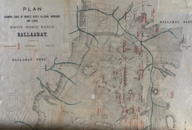
Plan, White Horse Range Ballarat, 1885, 06/1885
Two plans .1) Plan of the Ballarat Goldfields showing leads, rivers, streets and topography. Quartz reefs include: Yorkshire, Try Again, Promised Land, Western Slates, Norwegian, Robert's Lode, Finn's, Band and albion, Rothschild, Old Post Office, Queen Lode. Leads include: Navy jacks, Gays, Canadian, Prince Regent, Sailors Gully, White Horse, Little White Horse, Milkmans, Nightingale, Golden Point, Gravel Pits. Scale is 8 Chains to 1 inch .2) Plan showing lines of quartz reefs, alluvial workings and leads, White Horse Range, Ballarat. Leads include White Horse LEad, Little White Horse Lead, One Eye Gully, Terrible Lead, Sailor's Gully, Canadian Lead, Prince Regent Gully, Canadian Lead, Cavs Lead, Navy jacks Lead, Eureka Lead, Old Gravel Pits Lead, Gravel Pits Lead, Nightingale Lead, Malakoff Lead, Milkmans Lead, Redan Lead, Woolshed Lead, Jacksons Lead, Winters Lead, SCtochman's Lead, Canadian Lead. Reefs include: Promised Land, Daniash, Sir Garnet Wolsley, Norwegian, Rothschile, Band and Albion, Finns, Llanberis, Roberts Lode, Tynworths and Black Hill, Oregan, Yorkshire, Try Again, Yorkshire, Post Office, Clarke's, Western Slates, Black Slate, Danks Slates, Eastern Slates, Queen's Lode, Fire Brigade. Mines include Red Streak, New Chum, Tinworths, Woah Hawp, Normanby, Speedwell, Llanberris Extended, Llanberis, Last Chance, Major, Countess, Pioneer and a number of batteries along Main Road Hills include: Mount Clear, Pennyweight Hill, Sovereign Hillballarat, plan, white horse range, white horse, goldfields, mines, reefs, indicators, leigh river, cgt, tinworth, mining -
Glenelg Shire Council Cultural Collection
Plan - Plan / Line Drawing Port of Portland Slipway Cradle Tug ' Tarragal', n.d
Front: '39' - black texta, top right corner 'Timber by A.K.' 'Steel by R.T' - black textaport of portland -
University of Melbourne, Burnley Campus Archives
Plan, Detail of Sterilizing Trolley for New Plant Science Laboratory at Burnley Horticulture College, c. 1960
Plan by State of Victoria, Dept of Public Works. Drawn by R.M.department of public works, sterilizing trolley, plant science laboratory -
Moorabbin Air Museum
Plan (item) - Bristol Aeroplane 170 schematic drawings, Centre Plane Fin Outer Wing
Bristol Aeroplane Company Ltd -
 Kew Historical Society Inc
Plan - Subdivision Plan, Summerhill Estate, 1920-1940
Pru Sanderson, in her groundbreaking ‘City of Kew Urban Conservation Study : Volume 2 - Development History’ (1988), summarised the periods of urban development and subdivisions of land in Kew. The periods that she identified included 1845-1880, 1880-1893, 1893-1921, 1921-1933, 1933-1943, and Post-War Development. These periods were selected as they represented periods of rapid growth or decline in urban development. An obvious starting point for Sanderson’s groupings involved population growth and the associated economic cycles. These cycles also highlighted urban expansion onto land that was predominantly rural, although in other cases it represented the decline and breakup of large estates. A number of the plans in the Kew Historical Society’s collection can also be found in other collections, such as those of the State Library of Victoria and the Boroondara Library Service. A number are however unique to the collection.The Kew Historical Society collection includes almost 100 subdivision plans pertaining to suburbs of the City of Melbourne. Most of these are of Kew, Kew East or Studley Park, although a smaller number are plans of Camberwell, Deepdene, Balwyn and Hawthorn. It is believed that the majority of the plans were gifted to the Society by persons connected with the real estate firm - J. R. Mathers and McMillan, 136 Cotham Road, Kew. The Plans in the collection are rarely in pristine form, being working plans on which the agent would write notes and record lots sold and the prices of these. The subdivision plans are historically significant examples of the growth of urban Melbourne from the beginning of the 20th Century up until the 1980s. A number of the plans are double-sided and often include a photograph on the reverse. A number of the latter are by noted photographers such as J.E. Barnes.The Summerhill Estate was a subdivision in Glen Iris of 24 ‘choice allotments’. The lots were primarily on both sides of Dillon Grove. Other lots at each end of the subdivision faced Margaret Street and Summerhill Road. It was from the latter that the subdivision took its advertised title. The lots were originally advertised for £10 deposit with 20 subsequent payments over five years. Pencilled on the printed plan is a change to the deposit required; a reduction to 20/-. Annotations indicate that the new deposits ranged from 30/- to 45/-. The most expensive lots faced Summerhill Road. This subdivision plan is unusual in that the front and rear of the card are for subdivisions in different localities.subdivision plans - glen iris, summerhill estate -
Clunes Museum
Plan, Varley Bros, Proposed Turbine Creamery, 1894
Hand drawn plan on paperHandwritten in black ink: "These are the drawings referred to in our tender dated 7th September '94 for erection of creamery building at Glendaruel J Acrow *& Co. Contractorcreamery, turbines, plans, glendaruel, j bartram & son, varley bros -
Ballarat Clarendon College
Plan
Front view of the new school building to be erected on the corner of Sturt and Lyons Streets within the grounds of St Andrew’s Kirk to replace the earlier wooden structure on the same site. The building was designed by the noted Ballarat architect, Henry Caselli, and this drawing is taken from his original plans which were made available to the College in 1992 by L H Vernon and Associates Pty. Ltd. -
Port Melbourne Historical & Preservation Society
Plan - Path, Bay Street and Crockford Street, Municipality of Sandridge, 8 Oct 1861
Path works, west side of Bay Street and Crockford Street (both sides) bearing Seal of Municipality of Sandridge.Frederick William Ball, Muncipal Surveyor: Kellyengineering - roads streets lanes and footpaths, local government - borough of sandridge, frederick william bull, kelly (surveyor) -
Port Melbourne Historical & Preservation Society
Plan - Bus Shelter, Lorimer Street, Fishermans Bend, Engineering Department, City of Port Melbourne: A N B, 23 Mar 1942
Working drawings for the construction of bus shelter in Lorimer Street, Fishermens Bend, 1942. Preliminary design only. Subtitled "Design B" "Design A"Signed: Approved " ":Drawn: A. N. B.transport - bus, built environment - civic, fishermans bend, local government - city of port melbourne -
University of Melbourne, Burnley Campus Archives
Plan, Wilsons Promontory8119-I and Glennie 8119-IV, 1971
State Aerial Survey Plan of Wilsons Promontory and Glennie. Dated 1971. Provisional Compilation of Sheets 8119-I and 8119-IV from Commonwealth Department of National Development Photography for the Department of Crown Lands and Survey Victoria. Students made excursions to Wilsons Promontory.wilsons promontory, glennie group, anser group, bass strait, aerial survey -
 Federation University Historical Collection
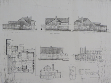
Plan - Plan (copy), 'Brick cased Residence 1515 Sturt Street West for Mrs H.L. Coburn, by H. Leslie Coburn, not dated
Ballarat born Herbert L. Coburn grew up to be a renowned Ballarat architect, practising from 1905 to 1956. He taught Architecture and Building Construction at the Ballarat School of Mines (SMB) from 1918, resigning in 1948 due to ill health.Copy of a plan by H.L. Coburn. It includes a front, west, east and rear elevation; ground plan, block plan; and layout plan. herbert l. coburn, h.l. coburn, coburn, architecture, herbert coburn, architectural plan -
 Bendigo Historical Society Inc.
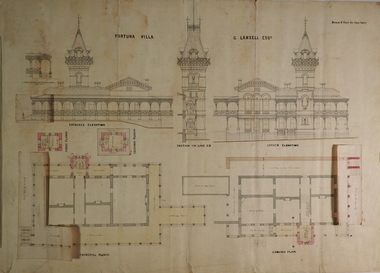
Plan - MARKS COLLECTION: PLAN FOR THE ADDITION OF A FOUR LEVEL STAIRCASE TOWER TO THE GARDEN ELEVATION OF FORTUNA VILLA FOR GEO. LANSELL ESQ
Fortuna Villa was owned from 1855 to 1871 by Christopher and Theodore Ballerstedt, Australia’s first mining magnates. In 1871 it was purchased by George Lansell (The Quartz King) being one of Australia’s most successful and adventurous nineteenth century gold mine owners and speculators. Lansell made numerous alterations extensions to the building and remained in the Lansell family until 1935Plan for the addition of a four level staircase to the Garden Elevation of Fortuna Villa for George Lansell Esq. Plan shows: * Four levels of the staircase cobstructiob - Ground, Principal, First & Second levels of the staircase tower, with viewing walk at the second level * Entrance & garden elevations section showing exterior of the four level additionfortuna villa, george lansell, c & t ballerstedt, building plans -
 Greensborough Historical Society
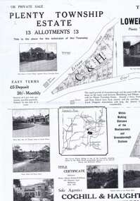
Plan - Advertising Leaflet, Coghill & Haughton, Plenty Township Estate and Bryn Teg Hill's Estate, 1925c
Copy of Real Estate Agent's advertising leaflet for two subdivisions, the Plenty Township Estate and Bryn Teg Hill's Estate in Lower Plenty, by order of Mrs M Thomas (d. 1925)Black and white photocopy of advertising leafletlower plenty, bryn teg, plenty river -
 Kew Historical Society Inc
Plan, Melbourne & Metropolitan Board of Works : Borough of Kew : Detail Plan No.1297, 1904
The Melbourne and Metropolitan Board of Works (MMBW) plans were produced from the 1890s to the 1950s. They were crucial to the design and development of Melbourne's sewerage and drainage system. The plans, at a scale of 40 feet to 1 inch (1:480), provide a detailed historical record of Melbourne streetscapes and environmental features. Each plan covers one or two street blocks (roughly six streets), showing details of buildings, including garden layouts and ownership boundaries, and features such as laneways, drains, bridges, parks, municipal boundaries and other prominent landmarks as they existed at the time each plan was produced. (Source: State Library of Victoria)This plan forms part of a large group of MMBW plans and maps that was donated to the Society by the Mr Poulter, City Engineer of the City of Kew in 1989. Within this collection, thirty-five hand-coloured plans, backed with linen, are of statewide significance as they include annotations that provide details of construction materials used in buildings in the first decade of the 20th century as well as additional information about land ownership and usage. The copies in the Public Record Office Victoria and the State Library of Victoria are monochrome versions which do not denote building materials so that the maps in this collection are invaluable and unique tools for researchers and heritage consultants. A number of the plans are not held in the collection of the State Library of Victoria so they have the additional attribute of rarity.Original survey plan, issued by the MMBW to a sewage contractor with responsibility for constructing sewers in the area identified on the plan within the Borough of Kew. The plan was at some stage hand-coloured, possibly by the contractor, but more likely by officers working in the Engineering Department of the Borough and later Town, then City of Kew. The hand-coloured sections of buildings on the plan were used to denote masonry or brick constructions (pink), weatherboard constructions (yellow), and public buildings (grey). This plan of Kew encompasses the area bounded by Barkers Road, High Street and Stevenson Street. Because of the angle created by High Street, a number of houses on the northern side of High Street are shown. The area is dominated by one of the great original landholdings in Kew, described here as the ‘Findon Paddock’. ‘Findon’, the house from which the name of the paddock was taken fronts Stevenson Street and was clearly a rambling structure. The best-known occupant of Findon was Henry ‘Money Miller’ who bought the house in 1871. Miller was a member of Victoria’s first parliament and assisted in the framing of its constitution. Findon was to be subdivided as early as 1912, when the Findon Subdivision was advertised to be sold by auction. In the plan of the subdivision, the original house is not shown, so, presumably it had previously been demolished. Fincham & Son moved the organ, built by Henry Willis, which was installed in the house, first to ‘Whernside’ in Toorak, and later to the Box Hill Methodist Church.melbourne and metropolitan board of works, detail plans, mmbw 1297, cartography, kew (vic.) — municipal collection -
 Kew Historical Society Inc
Plan - Subdivision Plan, Goldthorns Hill Estate, 1925
Pru Sanderson, in her groundbreaking ‘City of Kew Urban Conservation Study : Volume 2 - Development History’ (1988), summarised the periods of urban development and subdivisions of land in Kew. The periods that she identified included 1845-1880, 1880-1893, 1893-1921, 1921-1933, 1933-1943, and Post-War Development. These periods were selected as they represented periods of rapid growth or decline in urban development. An obvious starting point for Sanderson’s groupings involved population growth and the associated economic cycles. These cycles also highlighted urban expansion onto land that was predominantly rural, although in other cases it represented the decline and breakup of large estates. A number of the plans in the Kew Historical Society’s collection can also be found in other collections, such as those of the State Library of Victoria and the Boroondara Library Service. A number are however unique to the collection.The Kew Historical Society collection includes almost 100 subdivision plans pertaining to suburbs of the City of Melbourne. Most of these are of Kew, Kew East or Studley Park, although a smaller number are plans of Camberwell, Deepdene, Balwyn and Hawthorn. It is believed that the majority of the plans were gifted to the Society by persons connected with the real estate firm - J. R. Mathers and McMillan, 136 Cotham Road, Kew. The Plans in the collection are rarely in pristine form, being working plans on which the agent would write notes and record lots sold and the prices of these. The subdivision plans are historically significant examples of the growth of urban Melbourne from the beginning of the 20th Century up until the 1980s. A number of the plans are double-sided and often include a photograph on the reverse. The Goldthorns Hill Estate subdivision was first put up for auction in 1925. The subdivision took its name from the mansion ‘Goldthorns’, shown on the plan between Normanby Road and Lady Loch’s Drive. Contemporary advertisements describe forty-three home sites being fro sale, yet only forty-one appear on this plan. Buyers were lured by the prospect of the proposed extension of the Burke Road tram to High Street. Discerning buyers were advised that only one house could be built per allotment, and that houses needed to be constructed of brick, stone or concrete and have a slate or tiled roof.goldthorns avenue -- kew east (vic.), lady loch drive -- kew east (vic.), argyle road -- kew east (vic.), lady brassey drive -- kew east (vic.), campbell street -- kew east (vic.), goldthorns -- kew (vic.), subdivisions -- kew east (viv.), goldthorns hill estate -
Port Melbourne Historical & Preservation Society
Plan - Reclamation Fishermans Bend with material dredged from Coode Canal, Melbourne Harbor Trust, 1940
One of two A3 photocopies from MHTC plans of proposals for reclaiming Fishermans (sic) Bend with materials dredged from widening of Coode Canal, 1940 (Second copy missing April 2019)Pencil notations re Rotten Row etc.fishermans bend, engineering - canals and drainage, coode canal, melbourne harbor trust - port of melbourne authority -
Glenelg Shire Council Cultural Collection
Plan - Ship Plan / Mould, n.d
Wooden pattern for mould for boat fitting. Same as 6358, but different size.Back: '16 OFF' - black texta -
Moorabbin Air Museum
Plan (Item) - Mirage III Drawing , Wing Group Marking Details MIR III 0 092/4 F2
-
 Kew Historical Society Inc
Plan - Subdivision Plan, Wimba Estate, Kew, c.1925-c.1929, ca. 1925-ca. 1929
Pru Sanderson, in her groundbreaking ‘City of Kew Urban Conservation Study : Volume 2 - Development History’ (1988), summarised the periods of urban development and subdivisions of land in Kew. The periods that she identified included 1845-1880, 1880-1893, 1893-1921, 1921-1933, 1933-1943, and Post-War Development. These periods were selected as they represented periods of rapid growth or decline in urban development. An obvious starting point for Sanderson’s groupings involved population growth and the associated economic cycles. These cycles also highlighted urban expansion onto land that was predominantly rural, although in other cases it represented the decline and breakup of large estates. A number of the plans in the Kew Historical Society’s collection can also be found in other collections, such as those of the State Library of Victoria and the Boroondara Library Service. A number are however unique to the collection.Subdivision plans are historically important documents used as evidence of the growth of suburbs in Australia. They frequently provide information about when the land was sold on which a built structure was subsequently constructed as well as evidence relating to surveyors and real estate and financial agents. The numerous subdivision plans in the Kew Historical Society's collection represent working documents, ranging from the initial sketches made in planning a subdivision to printed plans on which auctioneers or agents listed the prices for which individual lots were sold. In a number of cases, the reverse of a subdivision plan in the collection includes a photograph of a house that was also for sale by the agent. These photographs provide significant heritage information relating house design and decoration, fencing and household gardens.In 1925, the City of Kew called for tenders for the construction of Wimba Avenue, Cadow Street and Lalla Street. Subsequent advertisements for the sale of land in Wimba Avenue continued from 1926 to 1929. The 18 lots (and a further five allotments on the eastern side of the street) offered for sale were unofficially described in the subdivision plan as the ‘Wimba Estate’. These lots began in Park Hill Road and extended almost to Cotham Road. The subdivision took its name from the house ‘Wimba’ in Cotham Road, which may have formed the southern boundary of the subdivision. (Wimba, at 235 Cotham Road was constructed between 1862-70). The Plan highlights the proximity and advantage of ‘electric’ trams in Cotham and Glenferrie Roads, and the Kew and Glenferrie Railway Stations. An oddity in the Plan is the reference to the electric tram terminus at Burke Road, given that the tramline had already been extended to Mont Albert in 1916.wimba estate, subdivision plans - kew, parkhill road – kew (vic.), normanby road – kew (vic.), wimba avenue – kew (vic.)