Showing 1650 items in the category Documentation with item type Plan
-
 Bendigo Historical Society Inc.
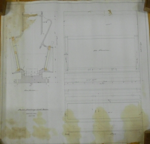
Plan - MARKS COLLECTION: DOUBLE DISCHARGE GOLD MORTAR
Plan drawn on buff paper, written on plan 'double discharge gold mortar' - no mine name given. Engineering drawings of gold mortar. 3 inches = 1 foot, September 1879.mining, equipment, lansell mine ? -
 Bendigo Historical Society Inc.
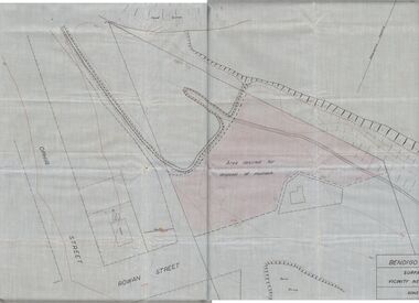
Plan - MCCOLL, RANKIN AND STANISTREET COLLECTION: PLAN OF MONUMENT HILL BATTERY
Pale blue waxed paper plan. Written on back of plan ' Monument Hill Battery site, area desired by Bendigo Mines (Nell Gwynne) for disposal of mullock. Plan shows Ophir Street, Rowan Street, Written on bottom RH corner 'Bendigo Mines Ltd., surface plan, vicinity Nell Gwynne Shaft, Scale 1" = 40' Magnetic north marked, sand dumps and contour lines.bendigo, business, mccoll, rankin & stanistreet -
 Kew Historical Society Inc
Plan - Subdivision Plan, Raheen Estate Subdivision, 1960
Subdivision plans are historically important documents used as evidence of the growth of suburbs in Australia. They frequently provide information about when the land was sold on which a built structure was subsequently constructed as well as evidence relating to surveyors and real estate and financial agents. The numerous subdivision plans in the Kew Historical Society's collection represent working documents, ranging from the initial sketches made in planning a subdivision to printed plans on which auctioneers or agents listed the prices for which individual lots were sold. In a number of cases, the reverse of a subdivision plan in the collection includes a photograph of a house that was also for sale by the agent. These photographs provide significant heritage information relating house design and decoration, fencing and household gardens.The Raheen Estate Subdivision of 1960 involved the creation of 36 residential allotments and the sale of 34 of these. The land on which the subdivision was created had until 1960 formed part of the grounds of the mansion Raheen in Studley Park Road. In 1917, the Catholic Church had purchased Raheen and its lands. It was to become the home of Archbishop of Melbourne, Daniel Mannix, for 46 years. The sale of the subdivision took place three years before the Archbishop’s death. Subsequent archbishops were to reside at Raheen until its sale to the Pratt family in 1981. When the sale of the Estate was reported in the newspapers in 1960, it was described as the last big subdivision near Melbourne. At the auction, 33 of the 36 allotments were sold. The auction realised £315,750. Purchasers were advised that the vendor intended to keep lots 22 and 23. The alllotments in the subdivision required the construction of new roads. These included Eamon Court and Raheen Drive. The justification provided by the Church for the sale was that the estate was being sold to finance school building projects.subdivision plans - kew, studley park, raheen estate, eamon court, studley park road, coombes avenue, raheen drive -
 Kew Historical Society Inc
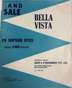
Plan - Subdivision Plan, Bella Vista, Doncaster East
The Bella Vista Subdivision included 101 lots in Murphy Road, Kerry Close, Keir Avenue, Norman Street, Daphne Street in Doncaster East,An undated, four-page colour brochure for the sale of the Bella Vista Estate in Doncaster East. The item includes a separate price list of the home sites maintained by the agent. The latter includes the original and the discounted price. subdivision plans - doncaster east (vic), bella vista subdivision - doncaster east (vic) -
 University of Melbourne, Burnley Campus Archives
Plan, Glenferrie PR. S. No. 1508: Detail Survey, 1982
Original and 2 copies of Public Works Department, Victoria plans of Glenferrie Primary School for the Department of Education SU 2241.2. Shows site plan of area bounded by Manningtree Road and Wattle Road. Pit Schedule of storm water and sewer pits.glenferre primary school, survey, victoria public works department, storm water, trees, p. manley (draftsman) -
 Federation University Historical Collection
Plan, Department of Crown Lands and Survey, Melbourne, Buninyong County of Grant, 23/07/1929
The plan was photo-lithographed at the Departmen tof Lands and Survey, MelbourneA parish plan of Buninyong, including Robert Scott's Mt Buninyong Pre-emptive Right, Mt Buninyong Public Park, Thomas Learmonth's land, John Learmonth's land, Scotchan's, Yendon. The Buninyong POst Office is Allotment 1. Pisition of tracks in 1859 have been marked on the plan in red.buninyong, scotchman's, mt buninyong, robert scott, clarendon, lal lal creek, yendon, warrenheip, yarowee, enfield, thomas learmonth, john learmonth, archibald fisken, g. schloo, george innes, peter inglis, durham lead, j. fry, j. forrest, parkin lee, buninyong recreation reserve -
Glenelg Shire Council Cultural Collection
Plan - Ship Plan / Mould, n.d
Wooden pattern for mould for boat fitting. Rectangular, bottom corners rounded; 2 metal spikes on top edge, one each end; dark stain. -
Federation University Historical Collection
Plan, Bill Pryor
Bill Pryor was the Deputy Vice Chancellor of the University of Ballarat.A number of photos of Bill Pryorbill pryor, university of ballarat -
Kew Historical Society Inc
Plan, Gwen McWilliam, Annotated Plan of the City of Camberwell, 1993
Gwen Barton McWilliam (nee: Nelson), OAM, BA (1933- ). Gwen McWilliam is well known as an authority on the history of Boroondara and the author of a large number of books and pamphlets about the City. She was awarded the medal of the Order of Australia in 2001 ‘for service to the community of Hawthorn and district, particularly through the research, documentation and publication of its history.’ Plan of Camberwell, Canterbury, Balwyn and Surrey Hills, forming part of a larger plan of the City of Boroondara, including annotations by the historian Gwen McWilliam, identifying significant landholdings, subdivisions and key dates. The plan was donated to the Kew Historical Society by Ms McWilliam. city of boroondara, subdivisions - camberwell, subdivisions - balwyn, subdivisions - surrey hills, subdivisions - canterbury, gwen mcwilliam -
Moorabbin Air Museum
Plan (Item) - Drawing Exterior Finishing Scheme Orion P3-B Aircraft , Drawing A16194, Sheet 1 Of 5 Sheets
-
 Port Melbourne Historical & Preservation Society
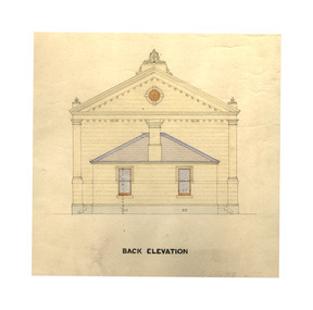
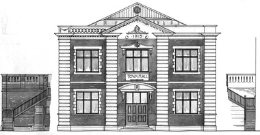
Plan - Town Hall, Sandridge, 1860s
Longitudinal, traverse, side and back elevation drawings for original Town Hall, Sandridge 1869 (No. 2) William Ireland:Witness Henry Bates:Reverse side: Plans of Town Hall, old and new. June 19th (pencil drawing)port melbourne town hall, built environment - civic, sandridge town hall -
 Port Melbourne Historical & Preservation Society
Plan - North west elevation, Port Melbourne Town Hall, Port Melbourne City Council, 1915
Plan - new (1915) Town Hall Port Melbourne, north west elevation, lonitudinal section A-A. Front elevation. Cross section B-B, Section C-C.port melbourne town hall -
University of Melbourne, Burnley Campus Archives
Plan, [Plan of Gardens], c. 1940?
Hand drawn plan of Gardens with some colour, on reverse of unused Certificate. Shows paths and beds in Ornamental Garden with grids drawn in pencil for planting lists. 2 photocopies of enlarged portion.Plan is drawn on verso of unused Diploma certificate from Royal Horticultural School Burnley, Department of Agriculture Victoria, with illustration of old Pavilion. On reverse, "Mr Kneen, Principal School of Horticulture Burnley," handwritten in pencil.ornamental gardens, burnley gardens, t. h. kneen -
University of Melbourne, Burnley Campus Archives
Plan (Item), Plan of Burnley Gardens, City of Richmond, Parish of Jika Jika, County of Bourke, 1948
(On original) : Notes by W(?) Anderson 28/2/45. Date stamp of School of Primary Horticulture and Agriculture Burnley E1burnley gardens, richmond, department of lands & survey, orchard -
 University of Melbourne, Burnley Campus Archives
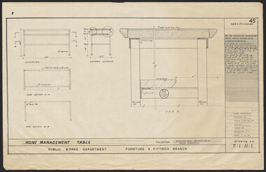
Plan, Home Management Table, 1959
Plan. Specification No. 45 for Home Management Table for Education Dept., High Schools. Drawing No. T:1:11:1 for Public Works Dept., Furniture & Fittings Branch, Chief Architect. Drawn by K.H.furniture -
Port Melbourne Historical & Preservation Society
Plan - Entrance, Proposed Port Melbourne Library, Fred Cook, City Engineer, 12 Jan 1938
Plan of entrance elevation City of Port Melbourne Library 1938."Library Details":"Fred Cook City Engineer"built environment - civic, city engineers, fred cook, port melbourne library -
 Federation University Historical Collection
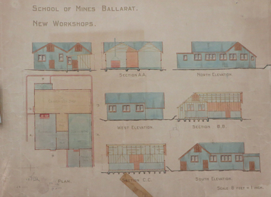
Plan, Ballarat School of Mines New Workshops, 1912, 08/1912
Original plan for new workshops for the Ballarat School of Mines. Includes elevations and sections, abd has been coloured with watercolour. The new workshops housed carpenters shop, plumbers, blacksmihing and stores. ballarat school of mines, new workshops, carpentry, blacksmithing, plumbing, architectural plan, laboratory -
Port Melbourne Historical & Preservation Society
Plan - Lyons Street, Port Melbourne, Borough of Sandridge, 9 Oct 1877
Plan of Lyons Street, showing longitudinal section, ground plan and transverse section.Minehan, Michael:Clark, Edward C (Town Clerk)engineering - roads streets lanes and footpaths, michael minahan, edward clark, town clerks -
Moorabbin Air Museum
Plan (item), Lock Spring Elec. Connector SD - E 268
-
 Federation University Historical Collection
Plan - Plans, Ballarat School of Mines Albert Street Buildings, 1979
The Trade Workshops became known as the M.B. John Building, and later housed Ballarat Tech.Eight printed plans with coloured shading of SMB Albert St buildings: .1) Locality Plan .2) Trade Workshop Site Plan .3) Trade Workshop Floor Plan Level A & B .4) Trade Workshop Floor Plan Level C .5) Trade Workshop Floor Plan Level D .6) Trade Workshop Floor Plan Level E .7) Trade Workshop West Elevation and Sections .8) Trade Workshop North Elevations and Sections building plans, smb trade workshops, ewan jones and associates pty ltd, architectural plan, m.b. john building, albert street -
Federation University Historical Collection
Plan, Ballarat University College Campus Plan, Mount Helen, 1993
Laminated large format site plan of the Ballarat University College (BUC) Campus.ballarat university college, campus plan, ian pratt, mount helen campus -
 Kew Historical Society Inc
Plan - Subdivision Plan, J R Mathers & McMillan, Normanby Estate, c.1913
The Kew Historical Society's map collection includes a substantial number of real estate subdivision plans, mainly of Kew but also of surrounding suburbs in Melbourne. Most of the subdivision plans date from the 1920s and 1930s when the districts old homes and local farmland were being split up to accommodate residential growth in the postwar period. These early plans were assembled by a local firm, Jas R Mather & McMillan, which had an office in Cotham Road. Many of the plans, and sometimes photos, were annotated by the agents.Subdivision plans are historically important documents used as evidence for the growth of suburbs in Australia. They frequently provide information about when the land was sold as well as evidence relating to surveyors and real estate and financial agents. The numerous subdivision plans in the Kew Historical Society's collection represent working documents, ranging from the initial sketches made in planning a subdivision to printed plans on which auctioneers or agents listed the prices for which individual lots were sold. In a number of cases, the reverse of a subdivision plan in the collection includes a photograph of a house that was also for sale by the agent. These photographs provide significant heritage information relating house design and decoration, fencing and household gardens.The photograph may also be aesthetically significant depending on the importance of the photographic atelier.The Normanby Estate, which was adjacent to Normanby Road, Kew East, included thirty-one lots for sale. Streets on the subdivision plan include Adeney Avenue, Park Hill Road, Normanby Road, Weir Street and Wharton Street. Cotham Road and its tramway are shown nearby. The plan is interesting as it shows Wharton Street, named after the architect and town planner George Wharton, who was the first chairman of the Municipality of Kew. The street was to later be renamed Cecil Street. Also shown are proposed ‘Municipal Gardens’ where Parkhill Drive is now located."D" in top left corner. Stamped auctioneers contact details: "Jas. R. Mathers & Son & McMillan / Auctioneer & Land Salesmen, / 271 Collins Street / Melbourne" and Jas. R. Mathers / Estate & Financial Agent / Cotham Road / Kew".weir street - kew, wharton street - kew, normanby road - kew, cotham road - kew, municipal gardens - kew, park hill parkhill road - kew, braemar - kew, subdivision plans - kew -
University of Melbourne, Burnley Campus Archives
Plan, Aberfeldie, Trawalla, 1905
Photocopies of Melbourne Metropolitan Board of Works plan showing 2 adjoining house and garden sites in Toorak, Victoria, 'Aberfeldie' and 'Trawalla'. Handwritten, "Map 937a, Map 937b 'Trawalla', Map 937c, Map 937d."toorak, houses, melbourne metropolitan board of works, "aberfeldie", "trawalla" -
 Bendigo Historical Society Inc.
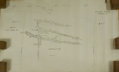
Plan - MARKS COLLECTION: LANSELL'S 180 PLAN, LEVELS 18, 19 AND 20
Plan of underground section of Lansell's 180 mine, levels 18, 19 and 20. On RH side of map Victoria Quartz Mining company claim marked, on LH side North Old Chum Co. 'West or hanging wall' marked above each level.bendigo, mining, lansell's little 180 mine -
 Federation University Historical Collection
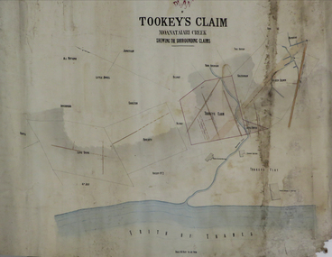
Plan, Tookey's Claim Moanataiari Creek, 1869?
Ink on paper plan with blue, red and orange shading tookey's claim, moanataiari creek -
Moorabbin Air Museum
Plan (item) - Bristol Aeroplanes170 Schematic Drawings, Wiring on Main Stbd Dash Mk21 A/C
Bristol Aeroplane Company Ltd -
Port Melbourne Historical & Preservation Society
Plan - Port Melbourne Town Hall, Engineering Department, Town of Port Melbourne, 1915
Plan of new (1915) Town Hall, Port Melbourne Foundation Plan, ground floor plan; first floor planport melbourne town hall -
Port Melbourne Historical & Preservation Society
Plan - Annotated and handcoloured by Peter LIBBIS to indicate his research into Libbis family residences and hotels on copy of a section of an MMBW map, Melbourne and Metropolitan Board of Works, c. 1980s
Peter LIBBIS obtained these copies from the MMBW when he researched his family history in the 1980s. He has annotated them, colour in hotels etc. Donated to Society in 1997.One of a group of 19 photocopies of various 20th century MMBW plans, annotated/coloured in to indicate residences of Libbis family and local hotels, by Peter LIBBIS in family and hotel research - Graham to Poolman, first bank houses 5.1.1930melbourne and metropolitan board of works, libbis family, business and traders - hotels, built environment - domestic, transport - railways -
Glenelg Shire Council Cultural Collection
Plan - Plan - S.S Admella Model Plans, SS 'Admella', n.d
Photocopy of model plan for lines and general arrangement of SS 'Admella'. scale 1:48. Photocopy paper is parchment style. Plan used by 'Float-a-boat' model makers for the construction of the Admella model acquired by Grant District council. -
University of Melbourne, Burnley Campus Archives
Plan, Horticultural & Experimental Garden in the Survey Paddock Richmond, 1862
Plan of site with area drawn in. From Office Dept. of Natural Resources.Handwritten on original: "To accompany letter from the Hon. Sec. of the Horticultural Society of Victoria to the Hon. The President of the Board of Land Works. A. Purchas, C.E. 9 October 1862 R 19 A1." and "Memo: The trees to be planted 50 feet apart in each row. AP"burnley, horticultural society of victoria