Showing 1652 items in the category Documentation with item type Plan
-
 Port Melbourne Historical & Preservation Society
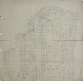
Plan - MMBW, Melbourne and Metropolitan Board of Works (MMBW), 1894 - 1895
Located on State Library Victoria (SLV) website by member Ray JelleyMelbourne Metropolitan Board of Works (MMBW) waste water (sewer) plans from 1894-95. Plan numbers 322, 331, 335, 564, 565, 575. Area bounded by Liardet St, East Esplanade, Foote St, Johns(t)on St and Hobsons Bay. Includes Gas works and Distillery.engineering - board of works, sewerage, mmbw, melbourne and metropolitan board of works -
Port Melbourne Historical & Preservation Society
Plan - Heath Street, Bridge Street and Spring Street, Sandridge, 16 Mar 1868
Plan of Heath, Bridge, North and South Spring Streets 1868 showing Bay St, Raglan St,Spring St, and Nott St, labelled. Spring St North, Spring St South, Bridge St and Heath St unlabelled; and transverse sections of the streets with measurements.Signed "Peter Mackey, Nicholas Mackey 16/5/68" Other names have been crossed out with pencil.built environment - civic, engineering department - borough of sandridge, engineering - roads streets lanes and footpaths, heath street, bridge street, borough of sandridge -
Glenelg Shire Council Cultural Collection
Plan - Plan - Port of Portland Slipway Cradle, 04/08/1983
port of portland -
University of Melbourne, Burnley Campus Archives
Plan, Richmond, 2001
Handdrawn plan of Burnley Campus and the surrounding Richmond area. Probably drawn by a student for Burnley Student Association. Found in former Staff Room 2012."Merryl 2001"burnley campus, richmond -
Port Melbourne Historical & Preservation Society
Plan - Danks Street from Pickles Street to Esplanade East, Town of Port Melbourne, 28 Feb 1893
Plan of Danks Street, from Pickles Street to Esplanade East and bearing the seal of the Borough of Port Melbourne as well as agreement to contract to carry out works.A.V. Heath (Town Surveyor):Michael Minahan (?) (Contractor):J.J. Bartlett (Mayor):Prohasky (Councillor):E.C. Crockford (Town Clerk):W. Harrison (Witness)engineering - roads streets lanes and footpaths, engineering - fences, local government - borough of port melbourne, arthur victor heath, james john bartlett, william henry prohasky, edward c crockford, town clerks, w harrison, michael minahan -
 Ringwood and District Historical Society
Plan - Proposed Ringwood East Railway Station, VR Ringwood-Croydon (Dublin Road) - 1923
Technical drawing of "Proposed Station At 16Mls 38Chs 89Lks (Dublin Road)" inluding boundary line, red shaded platform with station buildings, and green shaded possible future "up" track. Surrounding streets include Dublin Road, Patterson Street, and subsequent hand-written additions of Railway Avenue, Lawrence Grove, Stanley Avenue, Wenwood Street, and Lois Street. Land title details of Patterson Street properties mainly illegible.Scale: 40'=1". Possible future (platform) extension for 8 car trains (and) extension for 10 car trains. -
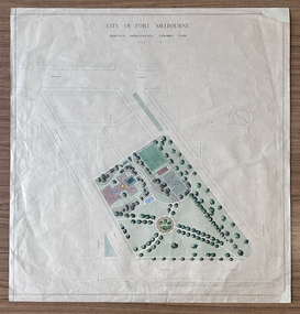 Port Melbourne Historical & Preservation Society
Plan - Edwards Park improvements (Trugo Green), Port Melbourne, 1940s - 1950s
Although undated, this plan is probably from the late 1940s or early 1950s. Around this time Port Melbourne Council were looking to built a basketball court in Lagoon reserve, and shelters and a senior citizen's clubhouse in Edwards Park. PMHPS does to believe the basketball court shown in the plan was built but the Port Melbourne Senior Citizens and Trugo Club is at the location shown on the plan. A shelter is in a similar location to the one on the plan. A children's playground existed in that location shown in a photograph from the 1930s. The round flowerbed where the paths cross in the centre of the park in not in the 1930s photograph but is a current feature of Edwards Park.Plan drawing to scale, hand coloured, of proposed improvements to Edwards Park (Trugo Green), undated possibly late 1940s or early 1950s."City of Port Melbourne"built environment - recreational facilities, parks and gardens, sport - trugo, port melbourne trugo club, edwards park -
Port Melbourne Historical & Preservation Society
Plan - Housing Commission Victoria, Erection of State houses, Fishermen's Bend, 1930s
Housing Commission Victoria. Plan of area at Fishermen's Bend Port Melbourne, to be used for erection of State houses. late1930sNotations in Pencil.town planning, garden city, fishermans bend -
University of Melbourne, Burnley Campus Archives
Plan, Proposed Site for Plant Science Laboratory and Glasshouse Block, 1964
Plan on tracing paper.laboratory, glasshouse -
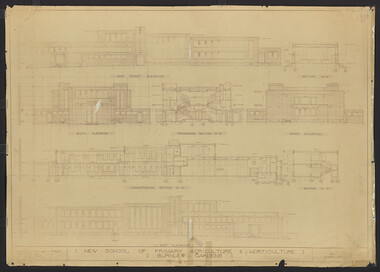 University of Melbourne, Burnley Campus Archives
Plan, New School of Primary Agriculture & Horticulture: Burnley Gardens, 1945
Original and photocopy of detailed architectural drawing and plan of new school by the Department of Public Works, Victoria Chief Architect, P. Everett.burnley school of horticulture, burnley gardens, percy everett -
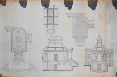
University of Melbourne, Burnley Campus Archives
Plan, Plans for courtyards at a hospital. Courtyards 1, 2 and 3; 4; 5 ; 6; Typical Courtyard sections; Functional areas
-
 Federation University Historical Collection
Plan, Madame Bent Gold Mining Company, not dated
A large plane showing a longitudinal section of the mine.madame bent gold mining company, mining -
Glenelg Shire Council Cultural Collection
Plan - Plan/ Line Drawing Portland Harbour Trust 'Galaxy', n.d
Front: '21' - black texta, top right cornerport of portland -
Moorabbin Air Museum
Plan (Item) - Dassault Mirage 111A Assembly Plan - French Language, Il Faut 1 Ensemble Gauche Suivant Dessin Droit Symetrique
Dassault Aviation -
 Federation University Historical Collection
Plan, Tatchera, not dated
2 copies of plan with shading printed on paper backed onto linentatchera -
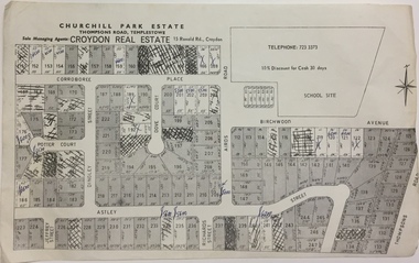 Kew Historical Society Inc
Plan - Subdivision Plan, Churchill Park Estate, Templestowe
Historic subdivision plan of the Churchill Park Estate in Templestowe.Undated subdivision plan advertising the Churchill Park Estate inTemplestowe. Streets identified in the plan include: Corroboree Place, Astley Street, Jeffrey Street, Airds Road, Dove Court, Potter Court, Thompsons Road, Richards Street, and Birchwood Avenue. This record includes a copy of the price list.Annotations in ink on the plan by agentsubdivision plans - templestowe (vic), churchill park estate - templestowe (vic) -
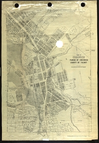 Federation University Historical Collection
Plan, Creswick, Parish of Creswick, County of Talbot, 1928, 1928
Parish Plan of Creswick showing Slaty Creek, Old Gold Workings, Police Reserve, Railway Station, Public Gardens, Sawpit Gully, Hospital Reserve, Nigh Soil Depot, Eureka Terracotta Tile COmpany, Creswick Creek, Forest COmmission, Roycroft's Racecreswick, eureka terracotta tile co, parish plan -
University of Melbourne, Burnley Campus Archives
Plan (Item), Vireya Rhododendrons
vireya rhododendron, burnley gardens -
 Kew Historical Society Inc
Plan, Melbourne & Metropolitan Board of Works : Borough of Kew : Detail Plan No.1571, 1904
The Melbourne and Metropolitan Board of Works (MMBW) plans were produced from the 1890s to the 1950s. They were crucial to the design and development of Melbourne's sewerage and drainage system. The plans, at a scale of 40 feet to 1 inch (1:480), provide a detailed historical record of Melbourne streetscapes and environmental features. Each plan covers one or two street blocks (roughly six streets), showing details of buildings, including garden layouts and ownership boundaries, and features such as laneways, drains, bridges, parks, municipal boundaries and other prominent landmarks as they existed at the time each plan was produced. (Source: State Library of Victoria)This plan forms part of a large group of MMBW plans and maps that was donated to the Society by the Mr Poulter, City Engineer of the City of Kew in 1989. Within this collection, thirty-five hand-coloured plans, backed with linen, are of statewide significance as they include annotations that provide details of construction materials used in buildings in the first decade of the 20th century as well as additional information about land ownership and usage. The copies in the Public Record Office Victoria and the State Library of Victoria are monochrome versions which do not denote building materials so that the maps in this collection are invaluable and unique tools for researchers and heritage consultants. A number of the plans are not held in the collection of the State Library of Victoria so they have the additional attribute of rarity.Digital copy of the original survey plan, issued by the MMBW to a contractor with responsibility for constructing sewers in the area identified on the plan within the Borough of Kew. The plan was at some stage hand-coloured, possibly by the contractor, but more likely by officers working in the Engineering Department of the Borough and later Town, then City of Kew. The hand-coloured sections of buildings on the plan were used to denote masonry or brick constructions (pink), weatherboard constructions (yellow), and public buildings (grey). This plan is part of a large and historically significant group of MMBW plans and maps that was donated to the Society by the Mr Poulter, City Engineer of the City of Kew in 1989. When the contracts were let for surveyors to identify and record the extant houses and landscapes within an area for the Board of Works, the contracts were let at separate times, hence the anomaly where two copies of Plan No.1571 exist in our collection. The first of these plans identifies the building materials used in houses bordering Fitzwilliam Street, Edgevale Road, May Street, Malin Street, Davis Street and Wellington Street. The cut off point for the survey was the south side of Wellington Street. By 1903 when the survey was undertaken many of the sites were already built on, particularly those facing Edgevale Road. The plan identifies the preponderance of weatherboard houses in the area. The other version of the plan identifies the buildings between Wellington Street and Cotham Road.melbourne and metropolitan board of works, detail plans, mmbw 1571, cartography -
University of Melbourne, Burnley Campus Archives
Plan, Planting Plan, c. 1980
Planting plan with critical notes. Scale 1:250plants, gardens, planting plan, construction plan, concept plan, model drawing -
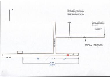 Bendigo Historical Society Inc.
Plan - Great Extended Hustlers, April, 2014
Seven men were killed at the Great Extended Hustler's mine disaster on 2nd May 1914 by an explosion of dynamite occurring as the men were waiting at the plat to ascend the mine at the end of their shift. No blame was attached to anyone in the findings of the inquisition. It was unknown what caused the dynamite to explode. This document formed part of the research done at the time by Bendigo Historical Society, of the 100 years commemoration of the mine disaster, held at Hustler's Hill in 2014. One page plan, computer generated, annotated to show the worksite of the miners prior to when the explosion occurred at the Great Extended Hustlers mine in May 1914. The location of Martin, Ryan, Thomas, Campbell, Blair and Chinn are described. great extended hustlers, goldmining, accident, 1914 -
University of Melbourne, Burnley Campus Archives
Plan, Landscape Design - option 2, 1988
Drawing 2/2. Dated August 1988. Landscape plan of unnamed propertylandscape design -
Glenelg Shire Council Cultural Collection
Plan - Original boat line plans of army diesel tug boat, 'Vigorous' (later renamed 'Emily S'), 10/07/1959
Eden Killer Whale MuseumOriginal boat line plans of army diesel tug 'Vigorous' later owned by Geoff Collett of Eden and later renamed 'Emily S' by Tony Santic. -
University of Melbourne, Burnley Campus Archives
Plan, Citrus Block, 1956
Rows 1-4 of Citrus Block in Orchard indicating Variety, Origin, Stock, When Planted, Remarks, dated 18.06.1956orchards, fruits, citrus -
Glenelg Shire Council Cultural Collection
Plan - Ship Plan / Mould, n.d
Wooden pattern for mould for boat fitting. 'Waisted' cylinder, circular knob attached to centre of each end. Painted orange. -
Glenelg Shire Council Cultural Collection
Plan - Plans / Line Drawings - Port of Portland Authority Trawling Vessel Sensation, Victoria, n.d
PORT OF PORTLAND AUTHORITYFront: '30' - black texta, top right corner -
Glenelg Shire Council Cultural Collection
Plan - Ship Plan / Mould, n.d
Wooden pattern for mould for boat fitting. Same as 6376, different size. -
University of Melbourne, Burnley Campus Archives
Plan, Nick Moore, Landscape Plan 12 Tyne Street Final Design Assignment, 2005
Coloured plan by Nick Moore dated June 2005. Scale 1:100.nick moore, landscape design -
 Bendigo Historical Society Inc.
Plan - MARKS COLLECTION: PLAN OF ALTERATIONS TO FORTUNA VILLA
Copy of plan for alterations and additions to Fortuna Villa. Plan shows various elevations of Fortuna entry, plan of basement, ground floor (entry) and ceiling in entry. Signed by W. Beebe, Architect.buildings, house, fortuna villa -
Glenelg Shire Council Cultural Collection
Plan - Plan - Port of Portland Slipway Fishing Vessel 'Gypsy Rose', 20/09/1983
port of portland