Showing 1652 items in the category Documentation with item type Plan
-
 Federation University Historical Collection
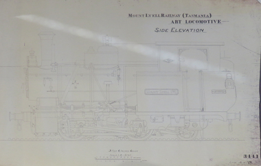
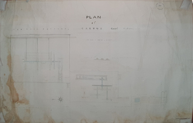
Plan, Mount Lyell Railway (Tasmania) ABT Locomotive Side Elevation, undated
On 29 March 1893 the Mount Lyell Mining and Railway Company was formed. This Tasmanian mining company was often referred to as Mount Lyell. Mount Lyell, and was the dominant copper mining company of the Tasmanian West Coast from 1893 to 1994, and was based in Queenstown, Tasmania. After consolidation of leases and company assets at the beginning of the twentieth century, Mount Lyell was the major company for the communities of Queenstown, Strahan and Gormanston. It closed in 1994. The Mount Lyell mining operations produced more than a million tonnes of copper, 750 tonnes of silver and 45 tonnes of gold since mining commenced in the early 1890s – which is equivalent to over 4 billion dollars worth of metal in 1995 terms.Copy of a plan of a locomotive.mount lyell, locomotive, mount lyell railway, quuenstown, tasmania, strahan, gormamston, railway -
 University of Melbourne, Burnley Campus Archives
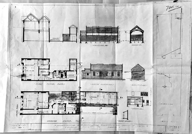
Plan, Landscape Construction, 1960-1990
Miscellaneous plans on tracing paper and paper related mainly to Landscape Construction (approx. 40 sheets)landscape construction -
 Port Melbourne Historical & Preservation Society
Plan - Drainage, 50 Beach Street, Port Melbourne, 18 Jan 1899
Photocopies (2) of black / white plan of drainage for Mr Warren, 50 Beach Street Port Melbournemmbw, melbourne and metropolitan board of works, f t warren -
Port Melbourne Historical & Preservation Society
Plan - Extension to weighbridge, Sandridge, George Kelly?, Borough Surveyor, 8 Nov 1864
Plan for extension of weighbridge, Borough of Sandridge, 1864.Numbered in red pencilengineering, borough of sandridge - engineering department, george kelly -
 Kew Historical Society Inc
Plan - Subdivision Plan, J R Mathers & McMillan, Glenarbor Estate, 1934
Pru Sanderson, in her groundbreaking ‘City of Kew Urban Conservation Study : Volume 2 - Development History’ (1988), summarised the periods of urban development and subdivisions of land in Kew. The periods that she identified included 1845-1880, 1880-1893, 1893-1921, 1921-1933, 1933-1943, and Post-War Development. These periods were selected as they represented periods of rapid growth or decline in urban development. An obvious starting point for Sanderson’s groupings involved population growth and the associated economic cycles. These cycles also highlighted urban expansion onto land that was predominantly rural, although in other cases it represented the decline and breakup of large estates. A number of the plans in the Kew Historical Society’s collection can also be found in other collections, such as those of the State Library of Victoria and the Boroondara Library Service. A number are however unique to the collection.The Kew Historical Society collection includes almost 100 subdivision plans pertaining to suburbs of the City of Melbourne. Most of these are of Kew, Kew East or Studley Park, although a smaller number are plans of Camberwell, Deepdene, Balwyn and Hawthorn. It is believed that the majority of the plans were gifted to the Society by persons connected with the real estate firm - J. R. Mathers and McMillan, 136 Cotham Road, Kew. The Plans in the collection are rarely in pristine form, being working plans on which the agent would write notes and record lots sold and the prices of these. The subdivision plans are historically significant examples of the growth of urban Melbourne from the beginning of the 20th Century up until the 1980s. A number of the plans are double-sided and often include a photograph on the reverse. A number of the latter are by noted photographers such as J.E. Barnes.The little-known Glenarbor Estate comprised 23 allotments bordering Wellington and Denmark Streets and Fenton Avenue. The auction of the allotments in the Estate was held in the Kew Recreation Hall. The purported advantages to Kew are identified on the plan, such as the close proximity of the entrance to the Kew Railway Station and access to shops in Denmark Street. Due to its location, the subdivision was pitched at commercial as well as residential purchasers. The Estate was to cause a crisis in the Kew Council as a majority of councillors voted on 29 May to acquire the entire Estate as the location of a new Town Hall. The Estate was said to be valued at £50,000. A later meeting was to rescind the vote, instead opting for the compulsory acquisition of South Esk on the corner of Charles Street and Cotham Road. That acquisition was to be overturned by the State Government. The debate about the purchase of the Glenarbor Estate by Council coincided with the decision to widen High Street on the South side between Cotham Road and the Junction."D"subdivision plans - kew, glenarbor estate, wellington street, denmark street -
 Mission to Seafarers Victoria
Plan, Arthur Peck, Victorian Missions to Seaman - Reconstruction of 139 Nelson Place, Williamstown and Erection of chapel, July 1943
After the closure of the Institute (former skating rink) on Thompson St, the Mission, thanks to the Williamstown Lightkeepers Auxiliaire and funds donated the High Commissioner of Canada, the former E,S & B Bank on Nelson Place was purchased and renovated. The St Nicholas chapel was added at the back of the building. Architects Arthur Peck and his eldest son, Hugh, were commissionned for the design. Arthur Peck was himself a keen yachstman. He died in 1945 at the age of 90.Large photocopie of original plans for the renovation of the E,S & B Bank building in Williamstown with the addition of the St Nicholas chapel.williamstown, williamstown lightkeepers auxiliary, arthur peck, hugh l. peck, st nicholas chapel -
Clunes Museum
Plan - TITLE PLAN, DEPARTMENT OF LANDS AND SURVEY, PARISH OF CLUNES - COUNTY OF TALBOT, 1959
.1 1 PAGE PLAN LISTING TITLES FOR THE PARISH OF CLUNES 1959 (3 COPIES) SHEET 1 SCALE: 1 INCH TO 40 CHAINS .2 1 PAGE PLAN LISTING TITLES FOR THE PARISH OF CLUNES 1959 SHEET 2 SCALE: 1 INCH TO 2 CHAINSBY AUTHORITY A C BROOKS GOVT. PRINTER, MELBOURNE PARISH OF CLUNESparish of clunes, title plans clunes -
 Kew Historical Society Inc
Plan - Subdivision Plan, Argyle Road, Heather Grove, Victor Avenue, Kew, c.1937
The Kew Historical Society's map collection includes a substantial number of real estate subdivision plans, mainly of Kew but also of surrounding suburbs in Melbourne. Most of the subdivision plans date from the 1920s and 1930s when the districts old homes and local farmland were being split up to accommodate residential growth in the postwar period. These early plans were assembled by a local firm, Jas R Mather & McMillan, which had an office in Cotham Road. Many of the plans, and sometimes photos, were annotated by the agents.Subdivision plans are historically important documents used as evidence for the growth of suburbs in Australia. They frequently provide information about when the land was sold as well as evidence relating to surveyors and real estate and financial agents. The numerous subdivision plans in the Kew Historical Society's collection represent working documents, ranging from the initial sketches made in planning a subdivision to printed plans on which auctioneers or agents listed the prices for which individual lots were sold. In a number of cases, the reverse of a subdivision plan in the collection includes a photograph of a house that was also for sale by the agent. These photographs provide significant heritage information relating house design and decoration, fencing and household gardens.The photograph may also be aesthetically significant depending on the importance of the photographic atelier.Undated blue subdivision plan in Kew of 14 lots facing Argyle Road, Heather Grove and Victor Road. The Plan identifies Tuxen & Miller as the surveyors. [Formerly catalogued as MAP.0059]subdivision plans - kew, argyle road - kew, heather grove - kew, victor avenue - kew -
 Bendigo Historical Society Inc.
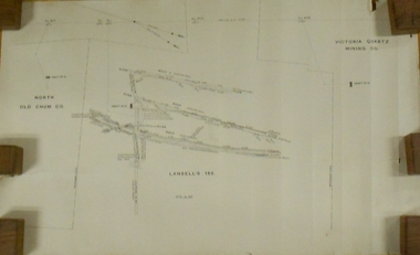
Plan - MARKS COLLECTION: LANSELL'S 180 PLAN, LEVELS 18, 19 AND 20
Plan of underground section of Lansell's 180 mine, levels 18, 19 and 20. On RH side of map Victoria Quartz Mining company claim marked, on LH side North Old Chum Co. 'West or hanging wall' marked above each level.bendigo, mining, lansell's little 180 mine -
Clunes Museum
Plan, 23RD SEPTEMBER,1854
GEOLOGICAL SKETCH PLAN AND LETTER FOR TWO RIGHTS CLAIMED BY DONALD CAMERON AT "CLUNES" - 320 ACRES IN THE WEST SIDE OF "CRESWICK CREEK" AND 160 ACRES IN EAST SIDE.1 .2 HANDWRITTEN GEOLOGICAL SKETCH/PLAN COMBINED WITH CORRESPONDENCE DATED 23 SEPTEMBER 1854 - FROM THOMAS BURR, SURVEYOR, 1854 AND PROVIDED TO THE SURVEYOR GENERAL. IT RELATED TO TWO RIGHTS CLAIMS BY PRESCRIPTION OF DONALD CAMERON ESQ.local history, plan, donald cameron, thomas burr, gold mining -
Port Melbourne Historical & Preservation Society
Plan - Port Melbourne Planning Scheme, Bayside Project Area, Development Plan. Comprehensive Development Zone No. 9 (Bayside Project Area). Local Section Port Melbourne Planning Scheme, Apr 1990
Development Plan. Comprehensive Development Zone No. 9 (Bayside Project Area). Local Section Port Melbourne Planning Scheme. 1990. Large white spiral bound folder.town planning - proposals shelved - bayside, local government - city of port melbourne, built environment, sandridge city development co pty ltd, scdc, beacon cove, mirvac -
 Federation University Historical Collection
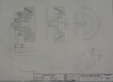
Plan - Engineering drawing, 'Friction Clutch', 1974
Student's technical drawing ballarat school of mines, technical drawing, r.h. livingston, alumni -
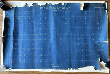 Port Melbourne Historical & Preservation Society
Plan, Pt Melbourne Cable Tramway, 1890s
One of three sheets of blueprints showing street configuration in Beach Street and Sandridge Road along Port Melbourne cable tram route. Indistinguishable signature of 'George ------ Esq., lower rightNotations in red crayon or penciltransport - tramways, transport - roads -
Glen Eira Historical Society
Plan - Nettalie
Land Victoria title documents vol 339 folio 763A and 764 relating to the property Nettalie on the corner of Balaclava and Orrong Rds. These documents detail the history of the land dealing relating to Nettalie and the neighbouring estate Harleston listed as parcels 209a and 209b. These dealing include grants of land, mortgages and conveyance (transfers). The documents include photocopies of handwritten notes of the title history date 1870; a partial copy of an instrument of conveyance dated 1863 and the original titles of the land owned at various times by William Noall, Alfred Shaw, Alfred Desailly and Sir Frederick Grimwade. Within the documents are various hand drawn and printed diagrams of the subdivisions.forsyth william, noall william, cutts william henry, shaw alfred, hailes george button, bakewell john, pascoe john randle, little william, fraser alexander, powell walter, whitney john, hodgeson richard, trollope william thomas, keep edward, blundell mary, carr john bonney, farie claud, fosberry john wallcott, davies john, brady michael, lloyd frederick, turner george, desailly alfred, grimwade frederick s sir, parish of prahran, county of bourke, caulfield north, st kilda east, balaclava road, orrong road, nettalie, netley house, harleston, melbourne grammar school, land subdivision, land sales, land titles, legal documents, homestead, schools, houses -
Friends of Ballarat Botanical Gardens History Group
Plan - Concept Design The Fernery Ballarat Botanic Gardens, Andrew Laidlow, August 2014
Photocopy of Planballarat botanical gardens, fernery, concept design, fernery layout -
University of Melbourne, Burnley Campus Archives
Plan, Atrium Planting, 1991
Student assignmentTracing paper copy of Plant Materials III Assignment 1991.atrium planting, planter box, garden design -
University of Melbourne, Burnley Campus Archives
Plan - Photocopy, Sheds Barn etc School of Horticulture, Burnley 1905 - 1906, 1905
2 photocopies. Sheds Barn Etc, School of Horticulture, Burnley. Elevations and Ground plan. Stamped GB 265 Dated 28th August 1905. From Public Records Office.sheds, burnley school of horticulture -
Moorabbin Air Museum
Plan (Item) - Drawing Exterior Finishing Scheme Orion P3-B Aircraft , Drawing A16194, Sheet 1 Of 5 Sheets
-
Port Melbourne Historical & Preservation Society
Plan - Drainage Improvements, Ross Street, Port Melbourne, Borough of Port Melbourne, 3 Nov 1892
Plan of Ross Street drainage improvement diversion drain, 1892.Signatures of J. J. Bartlett (Mayor), A. V. Heath (Borough Surveyor), W. Harrison, Laurence Brady (Contractor)engineering - canals and drainage, james john bartlett, arthur victor heath, town clerks, w harrison, laurence brady -
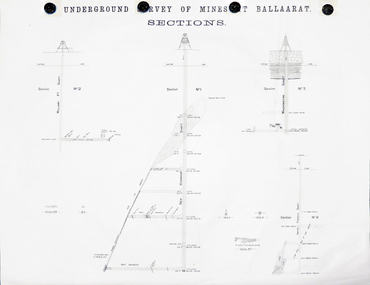 Federation University Historical Collection
Plan, Underground Survey of Mines at Ballarat Sections
A plan showing the underground sections of the Washington Shaft, Smith's Freehold Shaft and the New Kohinoor Shaft.plans, mining, cgt, washington shaft, smith's freehold shaft, new kohinoor shaft, koh-i-nor -
University of Melbourne, Burnley Campus Archives
Plan, City of Richmond Development of Old Burnley School Site, c. 1986
Plan for Park - area bounded by Madden Grove, Parkville, Stawell and Gibdon Streets Richmond. Scale 1:200. CP-72047186.richmond, burnley, burnley school, parks, golden square bicentennial park -
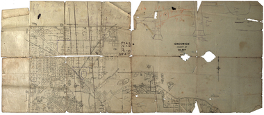 Federation University Historical Collection
Plan, Creswick, County of Talbot
This plan is associated with former Ballarat School of Mines Student Richard Squire (1875-1876). Gift of the Squire Family, 2014 Plan showing allotments in Creswick, County of Talbot. The plan is in a number of pieces with some sections missing.creswick, creswick creek, spring hill, sarah paterson, lehman, mullins, spittle, squire, richard squire -
Port Melbourne Historical & Preservation Society
Plan - Shelter shed, Borough of Sandridge, Mar 1877
Hand drawn plan and elevation of tiny shelter shed "at manure depot in common", Sandridge 1877.Signed by Edward Wilson and Charles Clay (Surveyor)local government - borough of sandridge, built environment - civic, edward wilson, charles clay -
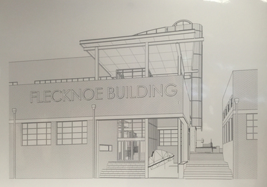 Federation University Historical Collection
Plan, Flecknoe Building Refurbishment Plans, 2017
Plans that were on display for opening of the refurnbished Flecknoe BuildingThree images of plans for the refurbishment of the Flecknoe Building at the Federation University SMB Building.ballarat school of mines, flecknoe builiding, refurbishment, buildings -
University of Melbourne, Burnley Campus Archives
Plan, Percy Everett, Layout Plan of Furniture & Fittings for School of Agriculture & Horticulture at Burnley, 1948
Plan for Library & Herbarium, Lecture Rooms 3 & 4, Plant Breeders Lab, Office & Assistant room, Agrostrological Lab. & Office, Demonstrator's Room. By Percy Everett, Architect.Many amendments in ink and pencillaboratory, percy everett, burnley school of agriculture and horticulture -
 Federation University Historical Collection
Plan, W. Watson, Plan of Caxton Company Smythesdale, 07/02/1886
Framed large ink drawing of a ten head battery, winding and pumping machines, gearhouse and framing. caxton company, smythesdale, w. watson, architectural plan -
Glenelg Shire Council Cultural Collection
Plan - Plans / Line Drawings - Port of Portland Authority Trawling Vessel Sensation, Victoria, n.d
PORT OF PORTLAND AUTHORITYFront: '30' - black texta, top right corner -
 University of Melbourne, Burnley Campus Archives
Plan, Lawn Drainage System, 1986
Tracing paper plan dated June 1986 showing details of drainage.drainage, lawns -
 Kew Historical Society Inc
Plan, Melbourne & Metropolitan Board of Works : Borough of Kew : Detail Plan No.1571, 1904
The Melbourne and Metropolitan Board of Works (MMBW) plans were produced from the 1890s to the 1950s. They were crucial to the design and development of Melbourne's sewerage and drainage system. The plans, at a scale of 40 feet to 1 inch (1:480), provide a detailed historical record of Melbourne streetscapes and environmental features. Each plan covers one or two street blocks (roughly six streets), showing details of buildings, including garden layouts and ownership boundaries, and features such as laneways, drains, bridges, parks, municipal boundaries and other prominent landmarks as they existed at the time each plan was produced. (Source: State Library of Victoria)This plan forms part of a large group of MMBW plans and maps that was donated to the Society by the Mr Poulter, City Engineer of the City of Kew in 1989. Within this collection, thirty-five hand-coloured plans, backed with linen, are of statewide significance as they include annotations that provide details of construction materials used in buildings in the first decade of the 20th century as well as additional information about land ownership and usage. The copies in the Public Record Office Victoria and the State Library of Victoria are monochrome versions which do not denote building materials so that the maps in this collection are invaluable and unique tools for researchers and heritage consultants. A number of the plans are not held in the collection of the State Library of Victoria so they have the additional attribute of rarity.Digital copy of the original survey plan, issued by the MMBW to a contractor with responsibility for constructing sewers in the area identified on the plan within the Borough of Kew. The plan was at some stage hand-coloured, possibly by the contractor, but more likely by officers working in the Engineering Department of the Borough and later Town, then City of Kew. The hand-coloured sections of buildings on the plan were used to denote masonry or brick constructions (pink), weatherboard constructions (yellow), and public buildings (grey). This plan is part of a large and historically significant group of MMBW plans and maps that was donated to the Society by the Mr Poulter, City Engineer of the City of Kew in 1989. When the contracts were let for surveyors to identify and record the extant houses and landscapes within an area for the Board of Works, the contracts were let at separate times, hence the anomaly where two copies of Plan No.1571 exist in our collection. The first of these plans identifies the building materials used in houses bordering Fitzwilliam Street, Edgevale Road, May Street, Malin Street, Davis Street and Wellington Street. The cut off point for the survey was the south side of Wellington Street. By 1903 when the survey was undertaken many of the sites were already built on, particularly those facing Edgevale Road. The plan identifies the preponderance of weatherboard houses in the area. The other version of the plan identifies the buildings between Wellington Street and Cotham Road.melbourne and metropolitan board of works, detail plans, mmbw 1571, cartography -
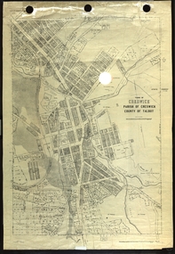 Federation University Historical Collection
Plan, Creswick, Parish of Creswick, County of Talbot, 1928, 1928
Parish Plan of Creswick showing Slaty Creek, Old Gold Workings, Police Reserve, Railway Station, Public Gardens, Sawpit Gully, Hospital Reserve, Nigh Soil Depot, Eureka Terracotta Tile COmpany, Creswick Creek, Forest COmmission, Roycroft's Racecreswick, eureka terracotta tile co, parish plan