Showing 1641 items
matching documentation
-
 Port Melbourne Historical & Preservation Society
Plan - Street levels, c. 1862
Drawn up to replace rescinded portions of street plan of March 1862.Plan of street levelsDetails and signatures as belowengineering - roads streets lanes and footpaths, frederick william bull, thomas swallow, edward clark, town clerks -
Port Melbourne Historical & Preservation Society
Plan - Unnamed Street, c. 1893
Plan for "unnamed street" (later Edwards, Morley) Loan Works 1893, plan no. 11 engineering - roads streets lanes and footpaths -
Moorabbin Air Museum
Plan (item) - Bristol Aeroplane 170 schematic drawings, Port Side Panel Harness
Bristol Aeroplane Company -
 Falls Creek Historical Society
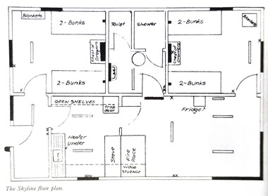
Plan - Floor plan Skyline Lodge, Bogong High Plains
MEYER COLLECTION - FALLS CREEK PHOTOS In 1947 a determined group of like-minded State Electricity Commission (SEC) staff including Ray Meyer, the chief surveyor of the Kiewa Hydro-Electric Scheme, had a common interest that revolved around the skiing potential of the snow-covered high plains which included what is now the resort of Falls Creek. The six SEC employees, Toni St Elmo, Ray Meyer, Jack Minogue, Lloyd Dunn, Adrian Ruffenacht and Dave Gibson (together with their families) banded together to secretly build a 'hut' that was the first ski lodge at Falls Creek. Using a road built in 1930s to gain access to Falls Creek, their hut project was carried out in secret as efforts by other skiers were blocked by H.H.C. Williams – the engineer in charge of the Hydro Scheme. In 1946 Ray Meyer made a trip to the Lands Office in Melbourne. He came away with a 99-year lease on three acres that was ideally suited for a hut designed by Lloyd Dunn. Adrian Ruffenacht (Design Engineer for the KHS) had suggested where the group should build because of easy access to a spring for water. Much of the building material required was scavenged from derelict huts on the high plains. Due to the need for secrecy, the determined group worked on the hut in the evenings and weekends to avoid detection. During the building period the group had met at Echidna Rock (now known as Eagle Rock) where Skippy St Elmo announced, "This is my favourite ‘Skyline’.” And so the first lodge in the area at Falls Creek Ski Resort came into existence. With the development of the International Poma in the 1970s, the Skyline Lodge, which was sited between the ski-lift’s pole one and pole two, was demolished. However, the legacy of Ray Meyer, Toni St Elmo, Jack Minogue, Lloyd Dunn, Adrian Ruffenacht and Dave Gibson and Skyline lives on in the vibrant atmosphere of Falls Creek Resort. The MEYER COLLECTION documents developments on the Kiewa Hydro Scheme and their life at Falls Creek from the mid 1930s to 1960s.This image is significant because it depicts developments made to "Skyline", the first lodge at Falls Creek.A floor plan of Skyline Lodge, probably after renovations were carried out by the Ski Club of Victoria which bought in to Skyline in 1950. In 1951 - 1952 a road up to the Lodge as well as drains, trenches and culverts were added. renovations to the lounge, basement drainage and porch resurfacing were completed in 1955. falls creek, victorian snowfields, skyline lodge -
 Friends of Ballarat Botanical Gardens History Group
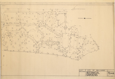
Plan - Survey Plan A, G. Creek, City of Ballarat Botanical Gardens
HistoricSurvey map on papersurvey map, city of ballaarat, ballarat botanical gardens -
 Kew Historical Society Inc
Plan - Subdivision Plan, Mount Ida Estate, 1925
The Kew Historical Society collection includes almost 100 subdivision plans pertaining to suburbs of the City of Melbourne. Most of these are of Kew, Kew East or Studley Park, although a smaller number are plans of Camberwell, Deepdene, Balwyn and Hawthorn. It is believed that the majority of the plans were gifted to the Society by persons connected with the real estate firm - J. R. Mathers and McMillan, 136 Cotham Road, Kew. The Plans in the collection are rarely in pristine form, being working plans on which the agent would write notes and record lots sold and the prices of these. The subdivision plans are historically significant examples of the growth of urban Melbourne from the beginning of the 20th Century up until the 1980s. A number of the plans are double-sided and often include a photograph on the reverse. A number of the latter are by noted photographers such as J.E. Barnes.The Mount Ida Estate was a subdivision of fifty-two residential allotments bordering Tooronga Road, Leura Grove, Constance Street, and Mount Ida Avenue in Hawthorn East. The report of the sale of the Estate in The Argus (21 September) claimed that over 1,000 people attended the auction and that all allotments were sold on the day. On the other side of Constance Street, the plan identifies the ‘Eastern Recreation Reserve’ (now Anderson Park).subdivision plans - hawthorn -
 Kew Historical Society Inc
Plan - Subdivision Plan, Violet Farm Estate, 1927
Pru Sanderson, in her groundbreaking ‘City of Kew Urban Conservation Study : Volume 2 - Development History’ (1988), summarised the periods of urban development and subdivisions of land in Kew. The periods that she identified included 1845-1880, 1880-1893, 1893-1921, 1921-1933, 1933-1943, and Post-War Development. These periods were selected as they represented periods of rapid growth or decline in urban development. An obvious starting point for Sanderson’s groupings involved population growth and the associated economic cycles. These cycles also highlighted urban expansion onto land that was predominantly rural, although in other cases it represented the decline and breakup of large estates. A number of the plans in the Kew Historical Society’s collection can also be found in other collections, such as those of the State Library of Victoria and the Boroondara Library Service. A number are however unique to the collection.The Kew Historical Society collection includes almost 100 subdivision plans pertaining to suburbs of the City of Melbourne. Most of these are of Kew, Kew East or Studley Park, although a smaller number are plans of Camberwell, Deepdene, Balwyn and Hawthorn. It is believed that the majority of the plans were gifted to the Society by persons connected with the real estate firm - J. R. Mathers and McMillan, 136 Cotham Road, Kew. The Plans in the collection are rarely in pristine form, being working plans on which the agent would write notes and record lots sold and the prices of these.The subdivision plans are historically significant examples of the growth of urban Melbourne from the beginning of the 20th Century up until the 1980s. A number of the plans are double-sided and often include a photograph on the reverse. A subdivision plan for nineteen ‘bonny, airy building blocks’ on either side of Violet Grove, Kew East. Violet Grove runs between High Street and Harp Road. Like many other subdivisions in Kew and East Kew, older houses (Lots 1 and 13) were often included in the subdivision. Such houses were in some instances the original properties that were subdivided, or in the case of the Violet Grove subdivision, new houses such as the weatherboard villa on lot 13. This villa is advertised as having a tiled roof, 5 rooms, panelled hall, double doors (Rooms 14 x 12 ft. 6 in. (2) 14 x 12, 12 x 11, 13 x 11). A bricked front verandah, a tiled stove recess and existing sewerage connection added to its saleable potential. Water, electric light and power, and gas were all offered as part of the deal. Violet Grove now has about 35 houses, which indicates that the 19 lots of the subdivision were to be further subdivided by purchasers. [A similar plan is in the Batten & Percy Collection of the State Library of Victoria.]subdivision plans - east kew, violet farm estate, violet grove -- kew (vic.), boorool road -- kew (vic.), harp road -- kew east (vic.) -
 Federation University Historical Collection
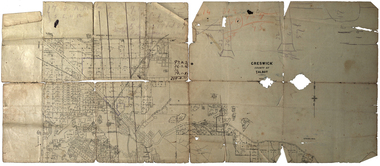
Plan, Creswick, County of Talbot
This plan is associated with former Ballarat School of Mines Student Richard Squire (1875-1876). Gift of the Squire Family, 2014 Plan showing allotments in Creswick, County of Talbot. The plan is in a number of pieces with some sections missing.creswick, creswick creek, spring hill, sarah paterson, lehman, mullins, spittle, squire, richard squire -
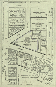
Port Melbourne Historical & Preservation Society
Plan - Sandridge and adjacent suburbs, 1860
Photocopy of plan of Sandridge c1860 and adjacent suburbs from Pt Ormond to Pt Gellibrand at Williamstown on the bay and Melbourne to Hawthorn to the north. Shows the loop railway line which connected the St Kilda line to that at Windsor.On back in pencil 'From Alex St John 4/1998'town planning, transport - railways -
Glenelg Shire Council Cultural Collection
Plan - Plan - Portland Sewerage Association, n.d
Portland Sewerage Authority Plan of Drainage for Mrs M Campbellcampbell family records -
 Federation University Historical Collection
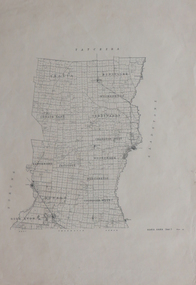
Plan, Kara Kara
Printed plan on paperkara kara, tatchera, gladstone -
Glenelg Shire Council Cultural Collection
Plan - Ship Plan / Mould, n.d
Wooden pattern for mould for boat fitting. Rod with U-shaped fitting attached to one end. Painted yellow -
Glenelg Shire Council Cultural Collection
Plan - Plans / Line Drawings - Port of Portland Authority Slipway Fishing Vessel Soluna, Victoria, 06/10/1989
Port of Portland AuthorityFront: '33'- black texta, top right corner. 'JOB NO 3110' - black pen -
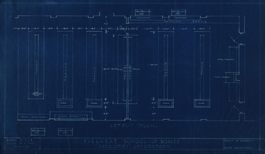
 Federation University Historical Collection
Plan, Ballarat School of MInes Allotments
-
Glenelg Shire Council Cultural Collection
Plan - Ship Plan / Mould, n.d
Wooden pattern for mould for boat fitting. Cylinder with two short wooden dowels protruding from top. Cylinder painted pale yellow, dowels unpainted. -
University of Melbourne, Burnley Campus Archives
Plan - Photocopy, Sheds Barn etc School of Horticulture, Burnley 1905 - 1906, 1905
2 photocopies. Sheds Barn Etc, School of Horticulture, Burnley. Elevations and Ground plan. Stamped GB 265 Dated 28th August 1905. From Public Records Office.sheds, burnley school of horticulture -
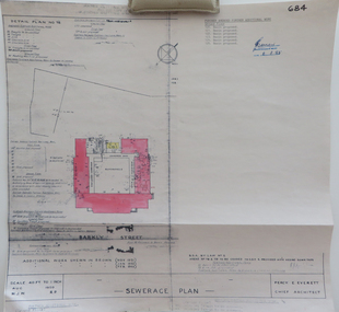
 Kew Historical Society Inc
Plan, Melbourne & Metropolitan Board of Works : Borough of Kew : Detail Plan No.1572, 1905
The Melbourne and Metropolitan Board of Works (MMBW) plans were produced from the 1890s to the 1950s. They were crucial to the design and development of Melbourne's sewerage and drainage system. The plans, at a scale of 40 feet to 1 inch (1:480), provide a detailed historical record of Melbourne streetscapes and environmental features. Each plan covers one or two street blocks (roughly six streets), showing details of buildings, including garden layouts and ownership boundaries, and features such as laneways, drains, bridges, parks, municipal boundaries and other prominent landmarks as they existed at the time each plan was produced. (Source: State Library of Victoria)This plan forms part of a large group of MMBW plans and maps that was donated to the Society by the Mr Poulter, City Engineer of the City of Kew in 1989. Within this collection, thirty-five hand-coloured plans, backed with linen, are of statewide significance as they include annotations that provide details of construction materials used in buildings in the first decade of the 20th century as well as additional information about land ownership and usage. The copies in the Public Record Office Victoria and the State Library of Victoria are monochrome versions which do not denote building materials so that the maps in this collection are invaluable and unique tools for researchers and heritage consultants. A number of the plans are not held in the collection of the State Library of Victoria so they have the additional attribute of rarity.Original survey plan, issued by the MMBW to a contractor with responsibility for constructing sewers in the area identified on the plan within the Borough of Kew. The plan was at some stage hand-coloured, possibly by the contractor, but more likely by officers working in the Engineering Department of the Borough and later Town, then City of Kew. The hand-coloured sections of buildings on the plan were used to denote masonry or brick constructions (pink), weatherboard constructions (yellow), and public buildings (grey). Plan No. 1572 represents the built environment bordered by Barkers Road, Wrixon Street, Edgevale Road and Fitzwilliam Street. Other streets identified on the plan include Stansell Street. Plan 1572 shows that by 1903-05, there was only patchy development in this area of Kew, mainly on Edgevale Road and Fitzwilliam Street. Only two named houses are identified: the quaintly named ‘Tweed Cottage’, and ‘Mendip’. The earliest reference to Treed Cottage in Australian newspapers is to the death of Walter Thompson, aged 74 who was a resident there in 1885. His youngest daughter was to die there in 1908. Mendip to the north of Tweed Cottage was owned by Henry Thompson; he was to die in 1901; his wife in 1932. At this period of time, Malin Street and Clivedon Court did not extend to Barkers Road.melbourne and metropolitan board of works, detail plans, mmbw 1572, cartography -
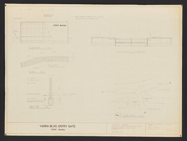 University of Melbourne, Burnley Campus Archives
Plan, J. Patrick et al, Yarra Blvd Entry Gate VCAH Burnley, 1988-1989
Design by J. Patrick, S. Mullany, drawn by S.M. On 07.01.1988, amended 12.01.1989. (1) On tracing paper. (2) On paper.j. patrick, s. mullany, vcah, burnley -
Glenelg Shire Council Cultural Collection
Plan - Ship Plan / Mould, n.d
Wooden pattern for mould for boat fitting. 8 pointed 'star' shape, around a cylinder, which protrudes further on front than back. Painted khaki.Back: '20 OFF' - biro -
Federation University Historical Collection
Plan, Ballarat School of Mines Amenity Centre, 1979, 06/1979
A 'birds-eye' (axonometric) of the proposed Ballarat School of Mines Student Centre, later named the Amenities Building.ballarat school of mines, amenities building, buildings, student amenity centre, ewan jones and associates, architects, vic mckay, plan -
University of Melbourne, Burnley Campus Archives
Plan - Photocopy, Burnley Gardens New Plant Research Laboratory, 1960
Sheet 1 of 8Photocopy, reduced in size, of original plan. Signed by Chief Architect, Dept of Public Works, Victoria. Site plan for new Plant Research Laboratory beside Existing Laboratory, dated ?.04.60, UCB.2.170. University of Melbourne - Property and Services has a better copy.plant research, laboratories -
 Federation University Historical Collection
Plan, Plan (dyeline): Ballarat Girls' School Sewerage Plan, 1950
Plan (dyeline) for Ballarat Girls' School sewerage plan percy everett, ballarat girls' school, sewerage plans -
University of Melbourne, Burnley Campus Archives
Plan, Burnley Campus Melbourne School of Land & Environment
site plan -
 Federation University Historical Collection
Plan, Tanjil Sheet 2, not dated
Printed plan on paper backed onto linen tanjil -
 Federation University Historical Collection
Plan, Ballarat School of Mines Chemistry Laboratory Plan, 10/11/1950
Four blue line plans relating to the Ballarat School of Mines Chemistry Laboratory.ballarat school of mines, chemistry, laboratory, percy everett, old chemistry building -
Moorabbin Air Museum
Plan - Hawker Hurricane, Model Airplane News
-
 Kew Historical Society Inc
Plan - Subdivision Plan, Eastlawn Estate, 1914
Subdivision plans are historically important documents used as evidence of the growth of suburbs in Australia. They frequently provide information about when the land was sold on which a built structure was subsequently constructed as well as evidence relating to surveyors and real estate and financial agents. The numerous subdivision plans in the Kew Historical Society's collection represent working documents, ranging from the initial sketches made in planning a subdivision to printed plans on which auctioneers or agents listed the prices for which individual lots were sold. In a number of cases, the reverse of a subdivision plan in the collection includes a photograph of a house that was also for sale by the agent. These photographs provide significant heritage information relating house design and decoration, fencing and household gardens.The ‘Eastlawn Estate’ was surveyed and ready for auction in March 1914, three months before the outbreak of World War I. Sixty-six allotments, created on the ‘order of Mr & Miss Preston’ surrounded the mansion of Woodlands in Harp Road. Woodlands formed part of the Estate, being advertised as lot 1. The allotments faced High, Station and Wright Streets, Harp and Normanby Roads, and Woodlands Avenue. Pru Sanderson in the Kew Conservation Study (Vol.2, 1988) wrote that the Eastlawn Estate ‘covered the western half of the failed Harp of Erin Estate’. Contemporary advertisements promoted the Eastlawn Estate as: ‘There will be no more convenient district nor pleasant Suburb than East Kew for the busy business man. When the Electric Tram is laid, he will be able to journey quickly and pleasantly direct from Collins Street to his home in the Eastlawn Estate in about 20 minutes’. The actual plans of subdivision were included in advertisements in The Argus and in the local newspapers.subdivision plans - east kew, eastlawn estate -
 Kew Historical Society Inc
Plan - Subdivision Plan, Mont Victor Hill Estate, 1936
Pru Sanderson, in her groundbreaking ‘City of Kew Urban Conservation Study : Volume 2 - Development History’ (1988), summarised the periods of urban development and subdivisions of land in Kew. The periods that she identified included 1845-1880, 1880-1893, 1893-1921, 1921-1933, 1933-1943, and Post-War Development. These periods were selected as they represented periods of rapid growth or decline in urban development. An obvious starting point for Sanderson’s groupings involved population growth and the associated economic cycles. These cycles also highlighted urban expansion onto land that was predominantly rural, although in other cases it represented the decline and breakup of large estates. A number of the plans in the Kew Historical Society’s collection can also be found in other collections, such as those of the State Library of Victoria and the Boroondara Library Service. A number are however unique to the collection.Subdivision plans are historically important documents used as evidence of the growth of suburbs in Australia. They frequently provide information about when the land was sold on which a built structure was subsequently constructed as well as evidence relating to surveyors and real estate and financial agents. The numerous subdivision plans in the Kew Historical Society's collection represent working documents, ranging from the initial sketches made in planning a subdivision to printed plans on which auctioneers or agents listed the prices for which individual lots were sold. In a number of cases, the reverse of a subdivision plan in the collection includes a photograph of a house that was also for sale by the agent. These photographs provide significant heritage information relating house design and decoration, fencing and household gardens.A preliminary plan for the Mont Victor Hill subdivision of 1936 which included 23 allotments bordering the Rimington Nursery in Mont Victor Road. The subdivision created allotments in Victor Avenue, Heather Grove and Burke Road. Bisecting the Estate and clearly marked on the plan is the Railway Reserve which at this stage was all that remained of the Outer Circle Railway. The auctioneers note on the plan that the subdivision was made possible by the order of Messrs S. H. Bennet & H. Wright, the executors of the Wills of S. Bennett & E. Foreman.mont victor hill estate, subdivision plans - kew -
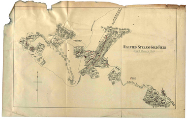 Federation University Historical Collection
Plan, Haunted Stream Gold Field
Plan of the Haunted Stream Gold Field - scale 16 chains to 1 inchhaunted stream, plan, battery -
Moorabbin Air Museum
Plan (item) - CAC Commonwealth Aircraft Corporation Stormwater Drains, Commonwealth Aircraft Corporation Pty Limited Stormwater Drain Layout
Commonwealth Aircraft Company