Showing 1650 items in the category Documentation with item type Plan
-
 Port Melbourne Historical & Preservation Society
Plan - Annotated and handcoloured by Peter LIBBIS to indicate his research into Libbis family residences and hotels on copy of a section of an MMBW map, Melbourne and Metropolitan Board of Works, c. 1980s
Peter LIBBIS obtained these copies from the MMBW when he researched his family history in the 1980s. He has annotated them, colour in hotels etc. Donated to Society in 1997.One of a group of 19 photocopies of various 20th century MMBW plans, annotated/coloured in to indicate residences of Libbis family and local hotels, by Peter LIBBIS in family and hotel research - Graham to Poolman, first bank houses 5.1.1930melbourne and metropolitan board of works, libbis family, business and traders - hotels, built environment - domestic, transport - railways -
Glenelg Shire Council Cultural Collection
Plan - Ship Plan / Mould, n.d
Wooden pattern for mould for boat fitting. Solid cylinder, metal screw protruding from one end, smaller diameter cylinder attached to other end. Painted yellow/orange. -
 Federation University Historical Collection
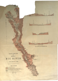
Plan, Geological Sketch Map of Portion of Big River
Printed map on paperscale, index to colours, sectionsgeological sketch map, plan, big river, mount wills, geology -
Glenelg Shire Council Cultural Collection
Plan - Ship Plan / Mould, n.d
Wooden pattern for mould for boat fitting. Cylinder, smaller diameter at each end; made in two pieces, held together by wooden dowels. Outside of each half painted white, inside unpainted.Back: '2 OF BRONZE' - pencil -
 Numurkah & District Historical Society
Plan - Plan of Numurkah Railway Station Fire Fighting Equipment
Part of railway collection from closed Numurkah Railway StationWooden Framed Blueprint Plan pasted onto a Masonite backing.VR Numurkah WS and Fire Fighting Equipment -
University of Melbourne, Burnley Campus Archives
Plan - Sketch, The Pergola at Balmoral, 1980s?
Coloured perspective sketch on tracing paper.pergola, balmoral -
 Federation University Historical Collection
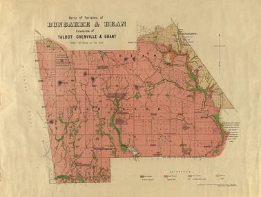
Plan, Bungaree and Dean Parish and Geological Plan, 1890, 07/1890
Ferdinand M. Krause was a Professor at the Ballarat School of Mines.Geological and Parish Map of parts of the Parishes of Bungaree and Dean in the Counties of Talbot, Grenville and Grant. The scale is 40 chains to one inch. bungaree, deen, krause, f.m. krause, musk creek, clarkes hill, badger hill, beale's reservoir, acquainted. -
 Bendigo Historical Society Inc.
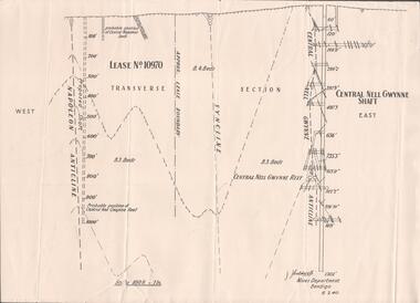
Plan - Mining Lease No. 10970, April, 2014
One page plan of Lease No. 10970, showing Napoleon Anticline and Central Nell Gwynne Shaft. Prepared by J. Caldwell, Mines Department Bendigo 6.2.1940.goldmining, quartz, mining, central nell gwynne gold mine, napoleon reef -
University of Melbourne, Burnley Campus Archives
Plan, Business Services, Burnley Campus, 27.11.2020
plan of burnley campus, university of melbourne -
Port Melbourne Historical & Preservation Society
Plan - Princes Pier Cafe, Port Melbourne
Cafe belonged to donor's parents.24 Black & white digital images & 2 coloured images of Princes Pier Cafeprinces pier cafe, cilia family -
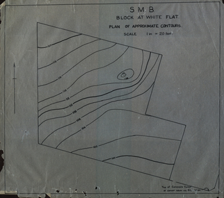 Federation University Historical Collection
Plan, SMB Block at White Flat
Plan of contours at White Flat, Ballarat Central. white flat, ballarat school of mines, ballarat central -
 Kew Historical Society Inc
Plan, Melbourne & Metropolitan Board of Works : Borough of Kew : Detail Plan No.1585, 1904
The Melbourne and Metropolitan Board of Works (MMBW) plans were produced from the 1890s to the 1950s. They were crucial to the design and development of Melbourne's sewerage and drainage system. The plans, at a scale of 40 feet to 1 inch (1:480), provide a detailed historical record of Melbourne streetscapes and environmental features. Each plan covers one or two street blocks (roughly six streets), showing details of buildings, including garden layouts and ownership boundaries, and features such as laneways, drains, bridges, parks, municipal boundaries and other prominent landmarks as they existed at the time each plan was produced. (Source: State Library of Victoria)This plan forms part of a large group of MMBW plans and maps that was donated to the Society by the Mr Poulter, City Engineer of the City of Kew in 1989. Within this collection, thirty-five hand-coloured plans, backed with linen, are of statewide significance as they include annotations that provide details of construction materials used in buildings in the first decade of the 20th century as well as additional information about land ownership and usage. The copies in the Public Record Office Victoria and the State Library of Victoria are monochrome versions which do not denote building materials so that the maps in this collection are invaluable and unique tools for researchers and heritage consultants. A number of the plans are not held in the collection of the State Library of Victoria so they have the additional attribute of rarity.Original survey plan, issued by the MMBW to a contractor with responsibility for constructing sewers in the area identified on the plan within the Borough of Kew. The plan was at some stage hand-coloured, possibly by the contractor, but more likely by officers working in the Engineering Department of the Borough and later Town, then City of Kew. The hand-coloured sections of buildings on the plan were used to denote masonry or brick constructions (pink), weatherboard constructions (yellow), and public buildings (grey). This plan, which covers parts of High Street, Pakington Street and Derby Street is dominated by two historic Kew mansions: ‘Konetta’ and ‘Ramornie’. Ramornie was constructed in 1890 for James Maitland Campbell, three times Mayor of Kew. Sold in 1940, it became a boarding house known as ‘The Towers’. Now a private residence again, it has only one of its three balconies remaining. The location of the missing two balconies can be seen on the plan. In 1903, the grounds of Ramornie included a large tennis court fronting Pakington Street. The rear of the property is shown as extending to Cobden Street. One of Kew’s oldest hotels, the Prospect Hill Hotel on the corner of High and Cobden Street was established in 1858. The outline of the hotel shown on the plan represents the second building on the site. During the 19th century it was often used for electoral meetings. The Prospect Hill Hotel was to be redeveloped again in 1928, by the local architect Robert McIntyre. Since the 1980s, the hotel has been a live music venue, the home of the Melbourne Jazz Club, a restaurant and a liquor outlet.melbourne and metropolitan board of works, detail plans, maps - borough of kew, mmbw 1585, cartography -
Kew Historical Society Inc
Plan - Saxonwood Estate, Doncaster [East]
Subdivision plans and real estate flyers/brochures reveal a number of aspects of urban development and history. The Kew Historical Society's collection of these plans, as well as advertisements extracted from magazines, cover key aspects of community development and architectural history of Kew and Kew Eat as well as surrounding suburbs. While most of the plans in the collection were gifted to the Society by the former City of Kew, a number of other plans and advertisements have been donated by individuals, of which this is an example.Undated, multi-page subdivision plan advertising lots for sale bounded by Blackburn Road, George Street, Windermere Avenue, and Saxonwood Drive in what is currently Doncaster East. Other streets in the subdivision include: Mowbray Court, Stafford Court, Rugby Court, and Robin Hood Court. The front page includes a Birdseye view of the estate which identifies existing and projected civic amenities, as well as the estate's relationship to surrounding suburbs and the city centre. Red crosses on the detailed plan of lots on page two indicate those that have been sold. The final page includes a locality plan. saxonwood estate -- doncaster east (vic.), subdivision plans -- doncaster east (vic.) -
Port Melbourne Historical & Preservation Society
Plan - Proposed docks and straight cut canal, Port Melbourne, Proposed Harbour Accommodation, 23 Sep 1902
Large plan of proposed docks and straight cut canal, reserve, proposed Harbour Accommodation - Port Melbourne. (Brown with age/or dirt) Shows enormous landfill into Hobson's Bay and around Town and Railway Piers; branch railway lines. Includes dredging plans and two narrow docks at Melbourne - also garden reserve and suburb of Fishermen's Bend.melbourne harbor trust - port of melbourne authority, town planning - proposals shelved, fishermans bend -
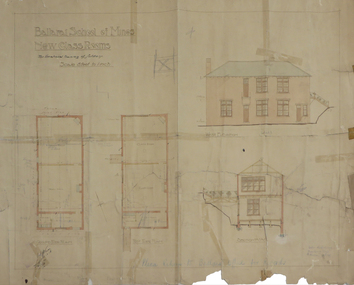 Federation University Historical Collection
Plan, Ballarat School of Mines New Classrooms, 1918
Hand drawn plan with coloured shading on paperballarat school of mines new classrooms, buildings, architectural plans -
Port Melbourne Historical & Preservation Society
Plan, Bay Street, C. 1990
A proposed plan for the development of Bay Street, Port Melbourne. The Street plan shows suggestions for tree planting, verandah changes, proposed open space & building use.bay street, built environment - commercial -
Port Melbourne Historical & Preservation Society
Plan - Facsimile, His Majesty's Bark Endeavour as fitted at Deptford, 1760, 1760
Facsimile of side view plan of His Majesty's Bark Endeavour, as fitted at Deptford in 1760. Printed matter which was avalable whilst the Replica Bark Endeavour was in Melbourne at Station Pier, November 1995transport - shipping, hm bark endeavour, james cook, endeavour replica -
Moorabbin Air Museum
Plan (item) - Joining Installation Composite Trainer United Technologies Sikorsky Aircraft
Drawing Number 65725-76201 -
University of Melbourne, Burnley Campus Archives
Plan, Victoria University of Technology Melton Campus, 1994
Photocopy of 'Feature and Level Survey' plan by WBCM group. Job No 4776/5 Sheet 1 of 1. Compilation Sheet Part of 477630A and 477631A. Dated 06.07.1994. Drawn b y RVvictoria university of technology, melton, wbcm surveys pty. ltd., feature survey -
 Falls Creek Historical Society
Plan - Diagram of Turnstile for New Chairlift
Bob (Herman) Hymans (a former member of the Royal Netherlands Navy was born in Bloemendaal, Holland on 30th September 1922. During World War II he fought against the Japanese in the Dutch East Indies (now Indonesia) and was imprisoned in Changi and on the Burma Railway. After gaining qualifications as a Ski Instructor, Bob arrived in Falls Creek in May 1950. Working as an Instructor and Supervisor at Bogong Lodge, Bob decided his future was in accommodation. He was successful in negotiating an indenture for land from the State Electricity Commission (SEC). It took Bob two years to build his Grande Coeur Chalet but, tragically, it was burned down in August 1961. Bob also built the first Chairlift in Australia. This was a single chairlift and the structure was built from wooden electricity poles. He was constantly full of new ideas and proposals for the village. Bob Hymans died on 7th May 2007. This Collection of documents and letters tells the story of Bob’s endeavours to develop Falls Creek into the ski village it is today. This map is significant because it documents plans made by Bob Hymans for Falls CreekThis diagram is part of Bob Hymans documents. It is a detailed plan, including elevation, detail of pivot and the general arrangement views of a turnstile. This is part of overall plans for the construction of a new chairlift at Falls Creek. At bottom of diagrams: PLAN TURNSTILE/ GENERAL ARRANGEMENT Scale 1 1/2" = 1'- 0"map of falls creek, falls creek leases, falls creek 1980s -
Glenelg Shire Council Cultural Collection
Plan - Plans / Line Drawings - Port of Portland Authority, Victoria, n.d
Port of Portland AuthorityFront: '37'- black texta, top right corner -
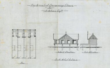 Bendigo Historical Society Inc.
Plan - Architectural drawings for Burnewang Homestead, Elmore, No date visible
Burnewang was built in 1903 for the Holmes Family. It is situated on the banks of the Campaspe river a few kilometres east of Elmore.Set of five Architect drawings of the Burnewang, Elmore Homestead showing, Elevations, Floor plans, Garden Layout, Details of the Fencing and the Dog Kennel. The plans were prepared for H Holmes.H. Holmes Esq.buildings, house, architect drawing, burnewang, elmore, holmes -
 Federation University Historical Collection
Plan, Site Plan of Ballarat School of Mines Campus, Lydiard St Ballarat, 1976
Copy of site plan of SMB campus showing existing buildings, Stage 2 buildings, and future buildings.ewan jones, smb stage 2, b barbour, building plans, ballarat school of mines, buildings, ballarat school of mines, architectural plans -
 Kew Historical Society Inc
Plan, Melbourne & Metropolitan Board of Works : Borough of Kew : Detail Plan No.1302, 1910
The Melbourne and Metropolitan Board of Works (MMBW) plans were produced from the 1890s to the 1950s. They were crucial to the design and development of Melbourne's sewerage and drainage system. The plans, at a scale of 40 feet to 1 inch (1:480), provide a detailed historical record of Melbourne streetscapes and environmental features. Each plan covers one or two street blocks (roughly six streets), showing details of buildings, including garden layouts and ownership boundaries, and features such as laneways, drains, bridges, parks, municipal boundaries and other prominent landmarks as they existed at the time each plan was produced. (Source: State Library of Victoria)This plan forms part of a large group of MMBW plans and maps that was donated to the Society by the Mr Poulter, City Engineer of the City of Kew in 1989. Within this collection, thirty-five hand-coloured plans, backed with linen, are of statewide significance as they include annotations that provide details of construction materials used in buildings in the first decade of the 20th century as well as additional information about land ownership and usage. The copies in the Public Record Office Victoria and the State Library of Victoria are monochrome versions which do not denote building materials so that the maps in this collection are invaluable and unique tools for researchers and heritage consultants. A number of the plans are not held in the collection of the State Library of Victoria so they have the additional attribute of rarity.Original survey plan, issued by the MMBW to a contractor with responsibility for constructing sewers in the area identified on the plan within the Borough of Kew. The plan was at some stage hand-coloured, possibly by the contractor, but more likely by officers working in the Engineering Department of the Borough and later Town, then City of Kew. The hand-coloured sections of buildings on the plan were used to denote masonry or brick constructions (pink), weatherboard constructions (yellow), and public buildings (grey). The absence of buildings and or property in Kew facing the Yarra is the most notable feature of this plan. Walmer Street and its bridge stretched, then and now, from Studley Park Road to Victoria Street, Richmond. On the Richmond side of the Yarra, there was evidence in 1904 of industry (‘Wool shed’; Soap Works’) and entertainment (‘Skittle Alley’). In reality, another Plan (No.1303) shows Chinese Gardens bordering the Yarra on the Kew side and buildings in Young Street.melbourne and metropolitan board of works, detail plans, mmbw 1302, cartography -
Glenelg Shire Council Cultural Collection
Plan - Plans / Line Drawings - Port of Portland Authority, Steel work boat, Victoria, n.d
PORT OF PORTLAND AUTHORITYFront: '7'- black texta, top right corner -
University of Melbourne, Burnley Campus Archives
Plan (item) - Plans, New Chemical Store
Includes Internal Memoranda and Bore Log dated18.12.1989 -
Glenelg Shire Council Cultural Collection
Plan - Plan - Port of Portland Slipway Tug Boat 'Buccaneer', 02/10/1989
port of portland -
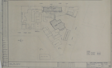
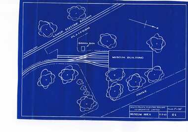 Ballarat Tramway Museum
Plan, South Pacific Electric Railway, SPER Museum Area, 9/09/1960 12:00:00 AM
A blueprint of drawing 01 of the South Pacific Electric Railway showing 1960 proposal for the layout of the SPER Museum area, scale 1" = 32'. Drawing No. 01, Shows NSWGR railway. Scan added and entry updated 19-8-13trams, tramways, sper, loftus, museum plan -
Moorabbin Air Museum
Plan (item) - C.A.C Winjeel Ambulance X.P.61. P.277
-
University of Melbourne, Burnley Campus Archives
Plan, Delysia Westwood, Tree Survey Central Gardens, 1986
Numbered plan with legend of trees in Central Gardens [Hawthorn]: Height, Diameter, Rating and comments for each tree. Dated November 1986 by Delysia Westwood. Scale 1:500.delysia westwood, tree survey, central gardens