Showing 1653 items in the category Documentation with item type Plan
-
 Clunes Museum
Plan, CLUNES WATER SUPPLY
DRAWINGS MADE TO SET UP A PERMENT PIPED WATER SUPPLY TO NEW NORTH MINE, CLUNES, VICTORIA, AUSTRALIA1 PAGE PLAN WITH DRAWING OF CLUNES WATER SUPPLY ON WAXED PAPER USING RED, BLACK AND BLUE INKCLUNES WATER SUPPLY LONGITUDINAL SECTION OF CENTRE LINE OF THE LOWER AWUEDECT FROM WEIR A TO SERVICE RESERVOIR DRAWING 420 5 CONTRACT NO. 740 2 HORIZONTAL SCALE FOUR CHAINS TO AN INCH VERTICAL SCALE FORTY FEED TO AN INCH SIGNED BY OCTAVIUS LANGTREE WORKS ENGINEER 13/12/1870octavius langtree, peter lalor, clunes water supply -
Federation University Historical Collection
Plan, Barkley St Campus Diagram, 1985
Ink on paper plan: Barkley St Campus Diagram plan, smb, barkley st campus -
University of Melbourne, Burnley Campus Archives
Plan, Caroline Le Souef, Plan of the Gardens of the Zoological and Acclimatisation Society of Victoria, Royal Park, melbourne, 1877
Appears to be based on the design by Alfred Lynch in 1861 see B17.0076. From ' Little Worlds: Australian Zoological Gardens Part III UWA. Also see B18.0029 Similar plan.Copy of plan from the 'Proceedings of the Zoological and Acclimatisation Society of Victoria, Vol 4, 1877. Drawn by Caroline Le Souef and reproduced in the early Melbourne Zoo guides.caroline le souef, alfred lynch, zoological and acclimatisation society of victoria, royal park, g. purchas -
 Kew Historical Society Inc
Plan - Subdivision Plan, Raheen Estate Subdivision, 1960
Subdivision plans are historically important documents used as evidence of the growth of suburbs in Australia. They frequently provide information about when the land was sold on which a built structure was subsequently constructed as well as evidence relating to surveyors and real estate and financial agents. The numerous subdivision plans in the Kew Historical Society's collection represent working documents, ranging from the initial sketches made in planning a subdivision to printed plans on which auctioneers or agents listed the prices for which individual lots were sold. In a number of cases, the reverse of a subdivision plan in the collection includes a photograph of a house that was also for sale by the agent. These photographs provide significant heritage information relating house design and decoration, fencing and household gardens.The Raheen Estate Subdivision of 1960 involved the creation of 36 residential allotments and the sale of 34 of these. The land on which the subdivision was created had until 1960 formed part of the grounds of the mansion Raheen in Studley Park Road. In 1917, the Catholic Church had purchased Raheen and its lands. It was to become the home of Archbishop of Melbourne, Daniel Mannix, for 46 years. The sale of the subdivision took place three years before the Archbishop’s death. Subsequent archbishops were to reside at Raheen until its sale to the Pratt family in 1981. When the sale of the Estate was reported in the newspapers in 1960, it was described as the last big subdivision near Melbourne. At the auction, 33 of the 36 allotments were sold. The auction realised £315,750. Purchasers were advised that the vendor intended to keep lots 22 and 23. The alllotments in the subdivision required the construction of new roads. These included Eamon Court and Raheen Drive. The justification provided by the Church for the sale was that the estate was being sold to finance school building projects.subdivision plans - kew, studley park, raheen estate, eamon court, studley park road, coombes avenue, raheen drive -
Port Melbourne Historical & Preservation Society
Plan - Housing Commission, Crockford Street, Ingles Street and Raglan Street, Port Melbourne, 1950s
Plan of area Crockford, Ingles and Raglan StreetsHousing Commissionbuilt environment - industrial, w a pentland, sue pentland -
 Kew Historical Society Inc
Plan, Melbourne & Metropolitan Board of Works : Borough of Kew : Detail Plan No.1588, 1904
The Melbourne and Metropolitan Board of Works (MMBW) plans were produced from the 1890s to the 1950s. They were crucial to the design and development of Melbourne's sewerage and drainage system. The plans, at a scale of 40 feet to 1 inch (1:480), provide a detailed historical record of Melbourne streetscapes and environmental features. Each plan covers one or two street blocks (roughly six streets), showing details of buildings, including garden layouts and ownership boundaries, and features such as laneways, drains, bridges, parks, municipal boundaries and other prominent landmarks as they existed at the time each plan was produced. (Source: State Library of Victoria)This plan forms part of a large group of MMBW plans and maps that was donated to the Society by the Mr Poulter, City Engineer of the City of Kew in 1989. Within this collection, thirty-five hand-coloured plans, backed with linen, are of statewide significance as they include annotations that provide details of construction materials used in buildings in the first decade of the 20th century as well as additional information about land ownership and usage. The copies in the Public Record Office Victoria and the State Library of Victoria are monochrome versions which do not denote building materials so that the maps in this collection are invaluable and unique tools for researchers and heritage consultants. A number of the plans are not held in the collection of the State Library of Victoria so they have the additional attribute of rarity.Original survey plan, issued by the MMBW to a contractor with responsibility for constructing sewers in the area identified on the plan within the Borough of Kew. The plan was at some stage hand-coloured, possibly by the contractor, but more likely by officers working in the Engineering Department of the Borough and later Town, then City of Kew. The hand-coloured sections of buildings on the plan were used to denote masonry or brick constructions (pink), weatherboard constructions (yellow), and public buildings (grey). This plan shows the original configuration of the Kew Post Office, Court House and Police Station, which had opened in 1888. This configuration was to essentially remain until the purchase of the Court House and Police Station by the City of Boroondara in 2007 and its subsequent renovation. Interestingly, the MMBW surveyors incorrectly labelled parts of the complex. In the triangle in front of the Post Office, before the erection of the Kew Cenotaph in 1925, was located a lawn and the Queen Victoria Jubilee Fountain. While many of the shops on the south side of High street had been constructed by 1903 a number of sites were still used as vegetable gardens. Further along High Street, on the corner of Charles Street, the Salvation Army Barracks can be seen on the plan. These Barracks predate the later Citadel and ‘Young People’s Hall’ that were opened in 1919. At 22 Charles Street can be seen the house of James Venn Morgan. Hailed as the ‘father of Kew’, Morgan arrived in Melbourne in 1840. He was first engaged as a bookmaker, but a fortunate venture on the goldfields enabled him to purchase land in Kew. He conducted a market garden and dairy in Kew for many years.melbourne and metropolitan board of works, detail plans, maps - borough of kew, mmbw 1588, cartography -
University of Melbourne, Burnley Campus Archives
Plan, Atrium Planting, 1991
Student assignmentTracing paper copy of Plant Materials III Assignment 1991.atrium planting, planter box, garden design -
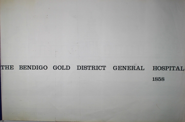 Bendigo Historical Society Inc.
Plan - THE BENDIGO GOLD DISTRICT GENERAL HOSPITAL PLAN, 1858
Blueprints: Set of blueprints, elevations and floor plans of the Bendigo Gold District General Hospital 1858. Contains 7 Drawings. Drawings of Vahland's Original Design for the Hospital. Measured drawings by Yuncken Freeman Atchitects Pty Ltd.Yuncken Freeman Architects Pty. Ltd.buildings, hospital, blueprint, bendigo hospital, floor plan, yuncken freeman -
Whitehorse Historical Society Inc.
Plan - Illustration, Nunawading Historical Museum, 1978
Plan of proposed display cabinet for period costumes, Nunawading Historical Museum.Plan of proposed display cabinet for period costumes, Nunawading Historical Museum, completed 11 Dec 1981. 14' : 1'0', with notes on suppliers by Harold A. Bakes.Plan of proposed display cabinet for period costumes, Nunawading Historical Museum. nunawading historical society, cabibet -
University of Melbourne, Burnley Campus Archives
Plan, Como, 1983, 1993
(1) Como Plant Inventory: Rear of House - Big Pond Lawn, Fountain Terrace and The Paddock dated November 1983, Landform Australia - photocopy in 2 sheets. Numbered list of plants and placement. (2) 2 copies Blueprint - Automatic Watering System Legend by Planned Irrigation Projects Pty. Ltd. (3) Tracing paper and paper plans of Croquet Lawn and Pony Paddock 'Como', Como Avenue, South Yarra - Landscape Studies Assignment 1993.como house, plant inventory, south yarra, irrigation -
Glenelg Shire Council Cultural Collection
Plan - Plans / Line Drawings Port of Portland Authority. 300 Tonne Slipway, 29/09/1989
Port of Portland Authority ArchivesLine drawing, PPA slipway, skeg support layout, tug 'Buccaneer'. Drawing no. 5581 -
Glenelg Shire Council Cultural Collection
Plan - Ship Plan / Mould, n.d
Wooden pattern for moulds for boat fittings. Flat, 'dagger' shape, round top, with round hole, pointed end, front painted brown, back white. -
Moorabbin Air Museum
Plan (item) - CAC Wirraway Agricultural Conversion XP.77 Drawing, C.A.C Wirraway Agricultural Conversion XP.77, 02/1957
This schematic was drawn by W. J. Watkins for the Commonwealth Aircraft Corporation during February 1957. It shows the XP-77 experimental conversion of the Wirraway general-purpose military aircraft. This drawing appears to depict the early stages of the CAC's Ceres design, which later had limited success as an agricultural aircraft carrying out tasks such as crop spraying. As the prototype first flew in February 1958, this diagram represents part of the development process for that aircraft. It also demonstrates an important phase in the history of the CAC, where, after the Second World War, the company was innovating in an attempt to stay relevant after the rapid shrinking of the RAAF. -
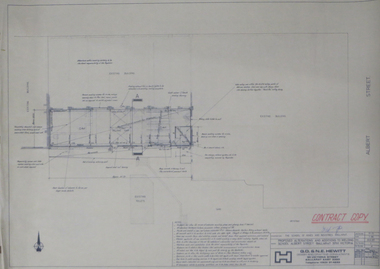 Federation University Historical Collection
Plan, Ballarat School of Mines Plans for Welding Additions
ballarat school of mines, buildings, g.d. & n.e. hewitt -
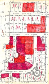 Ringwood and District Historical Society
Plan, Residential Land Sale Sub-division
Subdivision map of 60 residential allotments for sale in North Ringwood, Vic., circa 1968, with handwritten asking price annotations. Subdivision includes Lockhart Road, Goldsmith Avenue, Albany Close and Park Hill Drive. -
Glen Eira Historical Society
Plan - Carinya Road, 13, Bentleigh East
A typed letter dated 20/03/1974 from R T Breen and Co Solicitors to S P Simmonds and Co Real Estate Agents requesting a valuation of the property at 13 Carinya Court South Oakleigh (sic). It includes handwritten notes. The file also includes a copy of a typed letter dated 09/04/1974 to R T Breen containing the valuation of the property at 13 Carinya Court South Oakleigh (sic) by W V Scott. Also included is a handwritten, unattributed document of calculations and measurements for property at Carinya Court, South Oakleigh (sic). The file also includes a photocopy dated 18/03/1974 of the certificate of title for 13 Carinya Court, South Oakleigh (sic). This includes a hand drawn plan (70mm x 65mm) of the property.centre road, warrigal road, mackie road, coatesville state school, architectural features, slorach john henry, slorach christine margaret, wolai avenue, carinya road, carinya court, bentleigh east, oakleigh south -
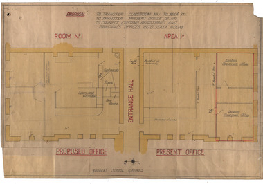 Federation University Historical Collection
Plan, Ballarat School of Mines Administration Building Proposal, 1948, 1948-1951
A hand drawn original drawing of a proposed Ballarat School of Mines office shift from the space on the south side of the entrance hall to the north side. Drawing shows the existing arrangement and also the proposed arrangement. "Proposal: To transfer classroom No 1 to the Area 1A, to transfer present office to No 1, to connect existing Registrar's and Principal's offices into the Staff room." On rear rubber stamp: "Received 28 Sep 1948 C & S"ballarat school of mines, administration building, a building, refurbishments -
Glenelg Shire Council Cultural Collection
Plan - Plans / Line Drawings - Port of Portland Authority, Victoria, n.d
Port of Portland AuthorityFront: '37'- black texta, top right corner -
Glenelg Shire Council Cultural Collection
Plan - Ship Plan / Mould, n.d
Wooden pattern for mould for boat fitting. Rectangular section with nail sticking out top, attached by short end to a larger rectangular block, which has rounded edges and a U-shaped opening one end. Painted yellow/orange. -
Glenelg Shire Council Cultural Collection
Plan - Plan / Line Drawings - Portland Harbour Trust Slipway Bilge Blocks Trawler Halcyon, Victoria, 23/04/1980
PORT OF PORTLAND AUTHORITYFront: '42' - black texta, top right corner -
Port Melbourne Historical & Preservation Society
Plan - Bow Fender, Inner East berth, Ferry Terminal, Station Pier, Port Melbourne, Port of Melbourne Authority, 1984
Plan - general arrangement of Bow Fender Station Pier - Inner East - Ferry Terminal - preliminary print only.melbourne harbor trust - port of melbourne authority, piers and wharves - station pier -
Federation University Historical Collection
Plan, Refurbishment Plans for Mount Helen Campus F Building, c2004
f building, plan, refurbishment, buildings -
Moorabbin Air Museum
Plan (item) - Bristol Aeroplane 170 schematic drawings, Auto Coarse Pitching Alternative Tubing
Bristol Aeroplane Company Ltd -
Port Melbourne Historical & Preservation Society
Plan - Evans Street from Ingles Street to Boundary Street, Engineering Department, Town of Port Melbourne, 1893 - 1919
Plan of Evans Street from Ingles Street to Boundary Street Loan no 5 1893.engineering - roads streets lanes and footpaths -
 Kew Historical Society Inc
Plan, Melbourne & Metropolitan Board of Works : Borough of Kew : Detail Plan No.1302, 1910
The Melbourne and Metropolitan Board of Works (MMBW) plans were produced from the 1890s to the 1950s. They were crucial to the design and development of Melbourne's sewerage and drainage system. The plans, at a scale of 40 feet to 1 inch (1:480), provide a detailed historical record of Melbourne streetscapes and environmental features. Each plan covers one or two street blocks (roughly six streets), showing details of buildings, including garden layouts and ownership boundaries, and features such as laneways, drains, bridges, parks, municipal boundaries and other prominent landmarks as they existed at the time each plan was produced. (Source: State Library of Victoria)This plan forms part of a large group of MMBW plans and maps that was donated to the Society by the Mr Poulter, City Engineer of the City of Kew in 1989. Within this collection, thirty-five hand-coloured plans, backed with linen, are of statewide significance as they include annotations that provide details of construction materials used in buildings in the first decade of the 20th century as well as additional information about land ownership and usage. The copies in the Public Record Office Victoria and the State Library of Victoria are monochrome versions which do not denote building materials so that the maps in this collection are invaluable and unique tools for researchers and heritage consultants. A number of the plans are not held in the collection of the State Library of Victoria so they have the additional attribute of rarity.Original survey plan, issued by the MMBW to a contractor with responsibility for constructing sewers in the area identified on the plan within the Borough of Kew. The plan was at some stage hand-coloured, possibly by the contractor, but more likely by officers working in the Engineering Department of the Borough and later Town, then City of Kew. The hand-coloured sections of buildings on the plan were used to denote masonry or brick constructions (pink), weatherboard constructions (yellow), and public buildings (grey). The absence of buildings and or property in Kew facing the Yarra is the most notable feature of this plan. Walmer Street and its bridge stretched, then and now, from Studley Park Road to Victoria Street, Richmond. On the Richmond side of the Yarra, there was evidence in 1904 of industry (‘Wool shed’; Soap Works’) and entertainment (‘Skittle Alley’). In reality, another Plan (No.1303) shows Chinese Gardens bordering the Yarra on the Kew side and buildings in Young Street.melbourne and metropolitan board of works, detail plans, mmbw 1302, cartography -
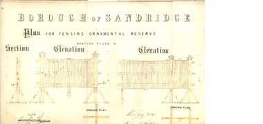 Port Melbourne Historical & Preservation Society
Plan - Fencing, Ornamental Reserve, Port Melbourne, 1879
Design of fensing (sic) for ornamental reserve (railway reserve) in Station Place North, 1879.Signed by Chas. Clay, Edward Wilson, E Clark, 1879.parks and gardens, engineering - fences, edward wilson, charles clay, edward clark, town clerks, railway reserve, station place -
Port Melbourne Historical & Preservation Society
Plan - Side balcony, Port Melbourne Town Hall, Port Melbourne City Council, 1916
Plan - Details of side balcony, doors and main windows (1915 Town Hall).port melbourne town hall -
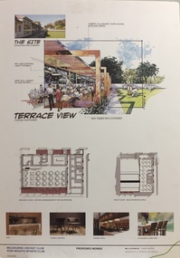 Kew Historical Society Inc
Plan - Architectural Sketch, MCC Kew Sports Club Proposed Works Terrace View, 2012
Sports Clubs in Kew in the final decades of the 19th century and in the early 20th century were often umbrella organisations with facilities for a number of sports. Typically in Kew, this included teams in lawn bowls, tennis and croquet. The Kew Bowling Club was formed in 1880 while the privately owned Auburn Heights Recreation Club was opened in 1904. By 1998, the two Clubs decided to amalgamate at the Auburn Heights site in Barkers Road, forming the Kew Heights Sports Club. The combined club was itself taken over by the Melbourne Cricket Club in 2012 becoming MCC Kew Sports Club. In 2017 MCC Kew closed and its landholding was subsequently sold to Carey Baptist Grammar School. Both the Kew and Auburn Heights Clubs assembled important collections. These historically significant and large collections were donated to the Society in 2020. The collections include manuscripts, pictures, trophies, plans, honour boards etc. The combined collections of the four sporting clubs making up the collection number hundreds of items that are historically significant locally. They are also significant to the sporting history of the greater Melbourne area and to the sports of lawn bowls and tennis in Australia in the 19th and 20th centuries. The collection illuminates two of the Victorian historic themes - 'Building community life' through forming community organisations and 'Shaping cultural and creative life' by participating in sport and recreation.Architectural sketches on corflute of proposed designs for the new MCC Kew Sports Club by McIldowie Partners (Architects & Interior Designers), 2012.mcc kew sports club - barkers road - kew (vic), mcildowie partners -- architects, architectural sketches -
Port Melbourne Historical & Preservation Society
Plan - Proposed Beacon Cove Development plan by Sandridge City Development Company Pty Ltd, 17 July 1989
A photocopy of a detailed of areas 14 & 15 of the plan for Beacon Cove from the Sandridge City Development Company Pty Ltd.sandridge city development company pty ltd, local government - city of port melbourne, beacon cove -
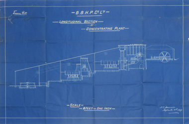 Federation University Historical Collection
Plan, Blueprint B.B.H.P. Co Ltd Longitudinal Section of Concentrating Plant, 1895
Blueprint plan by H.L. Hancock blueprint, h. l. hancock, longitudinal section, concentrating plant, bhp