Showing 1651 items in the category Documentation with item type Plan
-
 Moorabbin Air Museum
Plan (item) - Framing Assembly Cockpit (Composite Trainer) Sikorsky Aircraft
Drawing No.65725-75214 Rev.A -
Moorabbin Air Museum
Plan (Item) - Plan Aermacchi MB-339A Ex GAF
-
Port Melbourne Historical & Preservation Society
Plan - Annotated and handcoloured by Peter Libbis to indicate his research into Libbis family residences and hotels on copy of a section of an MMBW map, Melbourne and Metropolitan Board of Works, c. 1980s
Peter LIBBIS obtained these copies from the MMBW when he researched his family history in the 1980s. He has annotated them, colour in hotels etc. Donated to Society in 1997.One of a group of 19 photocopies of various 20th century MMBW plans, annotated/coloured in to indicate residences of Libbis family and local hotels, by Peter LIBBIS in family and hotel research - Harper's and lagoon, 1950s?business and traders - hotels, built environment - domestic, transport - railways, melbourne and metropolitan board of works, libbis family -
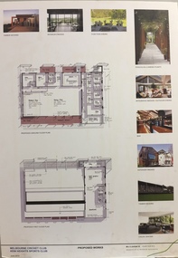 Kew Historical Society Inc
Plan - Architectural Sketch, MCC Kew Sports Club Proposed Works, 2012
Sports Clubs in Kew in the final decades of the 19th century and in the early 20th century were often umbrella organisations with facilities for a number of sports. Typically in Kew, this included teams in lawn bowls, tennis and croquet. The Kew Bowling Club was formed in 1880 while the privately owned Auburn Heights Recreation Club was opened in 1904. By 1998, the two Clubs decided to amalgamate at the Auburn Heights site in Barkers Road, forming the Kew Heights Sports Club. The combined club was itself taken over by the Melbourne Cricket Club in 2012 becoming MCC Kew Sports Club. In 2017 MCC Kew closed and its landholding was subsequently sold to Carey Baptist Grammar School. Both the Kew and Auburn Heights Clubs assembled important collections. These historically significant and large collections were donated to the Society in 2020. The collections include manuscripts, pictures, trophies, plans, honour boards etc. The combined collections of the four sporting clubs making up the collection number hundreds of items that are historically significant locally. They are also significant to the sporting history of the greater Melbourne area and to the sports of lawn bowls and tennis in Australia in the 19th and 20th centuries. The collection illuminates two of the Victorian historic themes - 'Building community life' through forming community organisations and 'Shaping cultural and creative life' by participating in sport and recreation.Architectural sketches on corflute of proposed designs for the new MCC Kew Sports Club by McIldowie Partners (Architects & Interior Designers), 2012. [The item forms part of the Kew Heights Sports Club collection (1998-2012), with items relating to the sports of lawn bowls and tennis, gifted to the Kew Historical Society in 2020].mcc kew sports club - barkers road - kew (vic), mcildowie partners -- architects, architectural sketches -
Moorabbin Air Museum
Plan (Item) - Airtrainer CT4 Plans
-
University of Melbourne, Burnley Campus Archives
Plan, Fooks Martin Sandow Pty. Ltd, V.C.A.H. Burnley Proposed Brick Paving Layout & Detail, c. 1970
Coloured plan by Fooks Martin Sandow Pty. Ltd.fooks martin sandow, burnley gardens, brick paving -
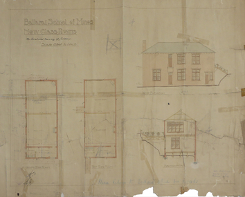
 Federation University Historical Collection
Plan, Balllarat School of MInes New Classrooms, 1899, 1899
Architectural plan for the New Classrooms at the Ballarat School of Mines, later known as the Administration Building.ballarat school of mines, new classrooms, administration building, a building, architectural plans -
Moorabbin Air Museum
Plan (item) - C.A.C Proposed RA-14 Avon Installation "Sabre" P251 XP.53
-
 Federation University Historical Collection
Plan, Ballarat School of Mines New Classrooms, 1918
Hand drawn plan with coloured shading on paperballarat school of mines new classrooms, buildings, architectural plans -
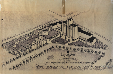 Federation University Historical Collection
Plan, Ballarat School of Mines Future Development: A Southern Terminal to Lydiard Street, 1947, 09/12/1947
In 1947 Percy Everett, Chief Architect for the Victorian Government, drew up plans to accomodate the growth in student numbers on the Ballarat School of Mines site. It was an era of government buildings surrounding the Ballarat School of Mines campus either being transfered to the school or foreshadowed for transfer. In 1947 two Red Cross huts were transferred from Victoria Park to the western side of the former Ballarat Supreme Court (later Courthouse Theatre) for use by Wool Classing and Motor Mechanics. In the same year additional facilities were provided for Pottery due to the increase in enrolments and a large brick classroom was built at the rear of the Ballarat Junior Technical School Building. In the annual report of 1947 the President said: "These transfers are, however, only temporary expedients and indicate the pressing need for more buildings of a permanent nature". By the end of the year the School Council decided to request the Education Department of Victoria to proceed with the implementation of the School's long-range plan whch had received approval earlier and to treat it as an urgent post-war requirement. After much communication a plan for a six-storied building, flanked by two three storied buildings was planned to be built on the site of the Ballarat Gaol was developed. The plan was sent to the Education Department for the Minister's Approval. It is not know if approval was granted, but the building did not proceed, possibly becausse the Ballarat Gaol was still very miuch in use. When a tertiary division of the Ballarat School of Mines was being developed in 1967 it corresponded with the closure of the Ballarat Gaol. It was determined that the Lydiard Street South site had no room for future growth so a new campus was sought. The new campus was purchased at Mt Helen, and was initially known as the Ballarat Insittute of Advanced Education. In 1976, when the Ballarat Teachers' College merged into the structure, the campus became known as the Ballarat College of Advanced Education and it was no longer a part of the Ballarat School of Mines. Plans for a proposed building to replace the Ballarat Gaol buildings. The proposed building was never built, the concept being replaced by a new teritary facility at Mt Helen. buildings, percy everett, ballarat school of mines battery, ballarat technical art school, engineering workshops, machine shop, ballarat junior technical school, architectural plans, ballarat school of mines, smb campus -
Federation University Historical Collection
Plan - Plans, Ballarat School of Mines Proposed Buildings for Horticultural Department, 1985
two ink on paper plans: .1) Proposed Buildings for Horticultural Department .2) as above plans, smb, horticultural department, ballarat school of mines, architectural plans, barkly street, horticulture -
Federation University Historical Collection
Plan, Alterations to the Ballarat School of Mines Electrical Engineering Department, 1947, 18/02/1947
Copy of a plan showing the Ballarat School of Mines Electrical Engineering Department, and wrought iron gates.ballarat school of mines, electrical engineering, buildings, architectural drawing -
Port Melbourne Historical & Preservation Society
Plan - Drainage works, cnr Crockford and Raglan Streets, Sandridge, George Kelly, Borough Surveyor, 6 Jun 1864
Ground plan for drainage work after flood 1864. Corner Crockford Street and Raglan Street.Borough of Sandridgeengineering department - borough of sandridge, engineering - canals and drainage, business and traders - hotels, george kelly -
 Bendigo Military Museum
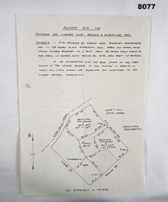
Plan - PROPOSED BDSC SITE, Bendigo RSL Sub Branch, C.1977
The plan relates to the proposed Bendigo & District Servicemen's Club in Havilah Road. The slightly shaded area is the site. This plan was put to a General Members meeting in September 1976. The club received its Liquor License in 1979. Refer Cat No 8073P for more details. This item was in the collection re David Patterson, refer Cat No 8070.Plan and details on A4 sheet, all text and sketch in black, top has site desired with 2 sets of remarks underneath, at bottom sketch of possible site on Havilah Road Bendigo."Desired site for proposed RSL Licenced Club, Memorial and recreational park"brsl, smirsl, bdsc, plan -
Port Melbourne Historical & Preservation Society
Plan - Tram and roadworks, Rouse Street between Esplanade East and Esplanade West, Engineering Department, Town of Port Melbourne, Mar 1893
Plan for tram and road works in Rouse Street between Esplanades East and West and adjacent to Lagoon Loan Works 1893 plan 19; relates to specification 99.1Signed by JJ Bartlett (Mayor) 14.3.1893engineering - roads streets lanes and footpaths, sandridge lagoon, transport - tramways, arthur victor heath, town clerks, james john bartlett, mayors -
 Kew Historical Society Inc
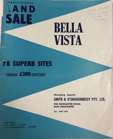
Plan - Subdivision Plan, Bella Vista, Doncaster East
The Bella Vista Subdivision included 101 lots in Murphy Road, Kerry Close, Keir Avenue, Norman Street, Daphne Street in Doncaster East,An undated, four-page colour brochure for the sale of the Bella Vista Estate in Doncaster East. The item includes a separate price list of the home sites maintained by the agent. The latter includes the original and the discounted price. subdivision plans - doncaster east (vic), bella vista subdivision - doncaster east (vic) -
Port Melbourne Historical & Preservation Society
Plan - Pool Street from Nott Street to Princes Street, Engineering Department, Town of Port Melbourne, 14 Mar 1893
Plan for Pool Street from Nott Street to Princes Street Loan Works 1893 plan 18; relates to specification 97.1Signed by JJ Bartlett (Mayor) 14.3.1893engineering - roads streets lanes and footpaths, town planning, town clerks, mayors, arthur victor heath, james john bartlett -
Port Melbourne Historical & Preservation Society
Plan - Sandridge, 1860
Original would have belonged to Joseph Turner, City Valuer 19th century and grandfather of member Ken Turner, who now holds original that he loaned to us for copying in 1998.Photocopy made from 1860 plan of Sandridge with proposals for various lots beyond the Lagoon, beyond the railway and even on the Railway Reservetown planning, built environment, joseph turner, land sales -
 Buninyong Visitor Information Centre
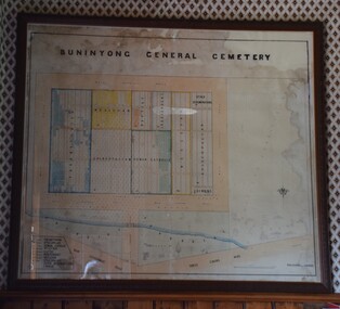
Plan - Cemetery Plan, Buninyong General Cemetery
Plan of the complete layout of the Buninyong General Cemetery drawn by Robert [surname unclear] on 6 April 1871.Framed and glazed original large hand drawn plan of the Buninyong General Cemetery, showing the locations of denominational sections and plots. Buninyong General Cemeterycemeteries, historic sites, buninyong -
Port Melbourne Historical & Preservation Society
Plan - Annotated and handcoloured by Peter Libbis to indicate his research into Libbis family residences and hotels on copy of a section of an MMBW map, Melbourne and Metropolitan Board of Works, c. 1980s
Peter LIBBIS obtained these copies from the MMBW when he researched his family history in the 1980s. He has annotated them, colour in hotels etc. Donated to Society in 1997.One of a group of 19 photocopies of various 20th century MMBW plans, annotated/coloured in to indicate residences of Libbis family and local hotels, by Peter LIBBIS in family and hotel research - North Port Station, Ingles to Bridgebusiness and traders - hotels, built environment - domestic, transport - railways, melbourne and metropolitan board of works, libbis family -
 University of Melbourne, Burnley Campus Archives
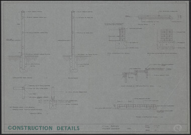
Plan, Construction Details Student Gardens Burnley Campus, 1990
Tracing paper copy, Construction details for student gardens. Dated1 9.09.1990. By JK (Jill Kellow) . Scale 1:100.student gardens, burnley, vcah burnley, jill kellow -
Glenelg Shire Council Cultural Collection
Plan - Plan / line drawing of a steel tuna vessel, c. 1978
Port of PortlandFront: '12'- black texta, top right cornerport of portland -
 Kew Historical Society Inc
Plan, Melbourne & Metropolitan Board of Works : Borough of Kew : Detail Plan No.1302, 1910
The Melbourne and Metropolitan Board of Works (MMBW) plans were produced from the 1890s to the 1950s. They were crucial to the design and development of Melbourne's sewerage and drainage system. The plans, at a scale of 40 feet to 1 inch (1:480), provide a detailed historical record of Melbourne streetscapes and environmental features. Each plan covers one or two street blocks (roughly six streets), showing details of buildings, including garden layouts and ownership boundaries, and features such as laneways, drains, bridges, parks, municipal boundaries and other prominent landmarks as they existed at the time each plan was produced. (Source: State Library of Victoria)This plan forms part of a large group of MMBW plans and maps that was donated to the Society by the Mr Poulter, City Engineer of the City of Kew in 1989. Within this collection, thirty-five hand-coloured plans, backed with linen, are of statewide significance as they include annotations that provide details of construction materials used in buildings in the first decade of the 20th century as well as additional information about land ownership and usage. The copies in the Public Record Office Victoria and the State Library of Victoria are monochrome versions which do not denote building materials so that the maps in this collection are invaluable and unique tools for researchers and heritage consultants. A number of the plans are not held in the collection of the State Library of Victoria so they have the additional attribute of rarity.Original survey plan, issued by the MMBW to a contractor with responsibility for constructing sewers in the area identified on the plan within the Borough of Kew. The plan was at some stage hand-coloured, possibly by the contractor, but more likely by officers working in the Engineering Department of the Borough and later Town, then City of Kew. The hand-coloured sections of buildings on the plan were used to denote masonry or brick constructions (pink), weatherboard constructions (yellow), and public buildings (grey). The absence of buildings and or property in Kew facing the Yarra is the most notable feature of this plan. Walmer Street and its bridge stretched, then and now, from Studley Park Road to Victoria Street, Richmond. On the Richmond side of the Yarra, there was evidence in 1904 of industry (‘Wool shed’; Soap Works’) and entertainment (‘Skittle Alley’). In reality, another Plan (No.1303) shows Chinese Gardens bordering the Yarra on the Kew side and buildings in Young Street.melbourne and metropolitan board of works, detail plans, mmbw 1302, cartography -
Port Melbourne Historical & Preservation Society
Plan - Shelter shed, Borough of Sandridge, Mar 1877
Hand drawn plan and elevation of tiny shelter shed "at manure depot in common", Sandridge 1877.Signed by Edward Wilson and Charles Clay (Surveyor)local government - borough of sandridge, built environment - civic, edward wilson, charles clay -
Moorabbin Air Museum
Plan - Assembly - L H Buffet F27, Trans-Australia Airlines
-
University of Melbourne, Burnley Campus Archives
Plan, 68-70 Dorcas St South Melbourne, 1989
Site/Roof plan by David Earle & Associates, Project No 1189 Drawing No A1. Designed by D.F.david earle, south melbourne, roof plans -
 Kew Historical Society Inc
Plan, Melbourne and Metropolitan Board of Works, Borough of Kew : Detail Plan No.1562, 1905
The Melbourne and Metropolitan Board of Works (MMBW) plans were produced from the 1890s to the 1950s. They were crucial to the design and development of Melbourne's sewerage and drainage system. The plans, at a scale of 40 feet to 1 inch (1:480), provide a detailed historical record of Melbourne streetscapes and environmental features. Each plan covers one or two street blocks (roughly six streets), showing details of buildings, including garden layouts and ownership boundaries, and features such as laneways, drains, bridges, parks, municipal boundaries and other prominent landmarks as they existed at the time each plan was produced. (Source: State Library of Victoria). This plan forms part of a large group of MMBW plans and maps that was donated to the Society by the Mr Poulter, City Engineer of the City of Kew in 1989. Within this collection, thirty-five hand-coloured plans, backed with linen, are of statewide significance as they include annotations that provide details of construction materials used in buildings in the first decade of the 20th century as well as additional information about land ownership and usage. The copies in the Public Record Office Victoria and the State Library of Victoria are monochrome versions which do not denote building materials so that the maps in this collection are invaluable and unique tools for researchers and heritage consultants. A number of the plans are not held in the collection of the State Library of Victoria so they have the additional attribute of rarity.Original survey plan, issued by the MMBW to a contractor with responsibility for constructing sewers in the area identified on the plan within the Borough of Kew. The plan was at some stage hand-coloured, possibly by the contractor, but more likely by officers working in the Engineering Department of the Borough and later Town, then City of Kew. The hand-coloured sections of buildings on the plan were used to denote masonry or brick constructions (pink), weatherboard constructions (yellow), and public buildings (grey). MMBW detail plan No.1562, in contrast to No.1561 includes the names of a large number of houses: in Barkers Road: ‘Ashwick’, ‘Owasso’, ‘Anadiha’, ‘Eurobin’, ‘Carlsruhe’, ‘Arlington’ and ‘Altyre’. Unnamed but clearly represented on the plan is what was then known as the ‘Auburn Heights Recreation Club’, which at this stage included a Bowling Green, a Croquet Green and two Tennis Courts. On the plan, Brougham Place, as it was then known, is represented. It was later renamed Daniell Place. The aforementioned Arlington is now the junior campus of Preshil. melbourne and metropolitan board of works, detail plans, mmbw 1562, cartography -
Port Melbourne Historical & Preservation Society
Plan - Improvments, Beach Street, Port Melbourne, Beach Street Improvements, 9 Nov 1915
Plan for Beach Street improvements 1915 - hand drawn in ink and hand coloured.Signed by Heath and Chairman RH Gill - Scale altered in red ink from 2ft to the inch to 4ft to the inch (at bottom centre)built environment - civic, arthur victor heath, town clerks, richard henry gill, mayors -
University of Melbourne, Burnley Campus Archives
Plan, Michael Green, 46 Young Street Kew Garden Concept Plan, 2000
Tracing paper plan by Michael Green dated December 2000. Scale 1:50michael green, gardens, kew -
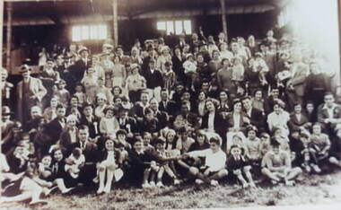 Ithacan Historical Society
Plan, Ithacan Picnic - group photo, c1940
The group were photographed at an annual Ithacan Philanthropic Society picnic.A sepia photograph of a large group of people photographed in front of a grand stand.