Showing 1657 items in the category Documentation with item type Plan
-
 Federation University Historical Collection
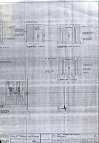
Plan - Building Plan, School of Mines: Administration Building Main Entrance, 22/09/1964
Photocopy of a plan produced by the Government of Victoria for alterations to the Main Entrance to the SMB Administration Building.ballarat school of mines, administration building, main entrance, lydiard street, a building, new classroom -
 Kew Historical Society Inc
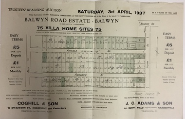
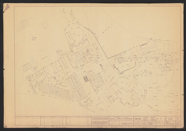
Plan - Subdivision Plan, Balwyn Road Estate, Balwyn (1937), 1937
Historic subdivision in Balwyn, VictoriaSubdivision Plan of Balwyn Road Estate (Balwyn). Held in April 1937, the auction included 102 lots for sale in Yongala Avenue, Young Street, and Balwyn RoadInscriptions on individual lots by agentsubdivision plans - balwyn (vic), balwyn road estate - balwyn -
 University of Melbourne, Burnley Campus Archives
Plan, Flat Concrete Roof & New Staff Room, 1981
(1) Photocopy of plan showing Flat Concrete Roof and New Staff Room. (2) Title of a plan which is probably of (1). Internal Modifications dated 4.6.81 by J.T. Crean, Ass't Director of Public Works. Donated by Sandi Pullman 2012.staff, sandra pullman -
Port Melbourne Historical & Preservation Society
Plan - House, 16 McCormack Street, Port Melbourne, 2000s
Plan of house 16 McCormack Street Port Melbourne. Property owned by Eileen Mary GILCHRISTjohn gilchrist, john james gilchrist, mary eileen gilchrist, families, domestic life, mccormack street -
 Melbourne Legacy
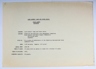
Plan - Document, plans, Lord Somers' Camp and Power House. Gully Lodge, Eppalock
Plans for the permanent camp site used by Melbourne Legacy in the second half of the 20th century.Most of the Junior Legatees would have stayed at Lord Somers' camp, which is still in use.6 photocopied plans and 1 cover sheet - A4 size - black on white, single sided.camp, lord somers camp, power house, eppalock -
 Federation University Historical Collection
Plan, Mount Helen Campus
Sketches of the Mount Helen campus, including topography.mount helen campus, architectural drawings -
 Kew Historical Society Inc
Plan - Subdivision Plan, Normanby Heights Estate, Kew, 1919
Prue Sanderson, in her groundbreaking ‘City of Kew Urban Conservation Study : Volume 2 - Development History’ (1988), summarised the periods of urban development and subdivisions of land in Kew. The periods that she identified included 1845-1880, 1880-1893, 1893-1921, 1921-1933, 1933-1943, and Post-War Development. These periods were selected as they represented periods of rapid growth or decline in urban development. An obvious starting point for Sanderson’s groupings involved population growth and the associated economic cycles. These cycles also highlighted urban expansion onto land that was predominantly rural, although in other cases it represented the decline and breakup of large estates. A number of the plans in the Kew Historical Society’s collection can also be found in other collections, such as those of the State Library of Victoria and the Boroondara Library Service. A number are however unique to the collection.The Kew Historical Society collection includes almost 100 subdivision plans pertaining to suburbs of the City of Melbourne. Most of these are of Kew, Kew East or Studley Park, although a smaller number are plans of Camberwell, Deepdene, Balwyn and Hawthorn. It is believed that the majority of the plans were gifted to the Society by persons connected with the real estate firm - J. R. Mathers and McMillan, 136 Cotham Road, Kew. The Plans in the collection are rarely in pristine form, being working plans on which the agent would write notes and record lots sold and the prices of these. The subdivision plans are historically significant examples of the growth of urban Melbourne from the beginning of the 20th Century up until the 1980s. A number of the plans are double-sided and often include a photograph on the reverse. A number of the latter are by noted photographers such as J.E. Barnes.The Normanby Heights Estate not unusually used hyperbole to attract purchasers to the auction of 17 lots facing Argyle Street (sic), Pleasant Avenue and Normanby Road. Predictably factors appealed to included the proximity to schools etc, the availability of public utilities, friable soil, picturesque views and ‘advancing settlement’. If that were not enough, the sales pitch exhorted prospective purchasers to consider their backbone. ‘Thrift is unquestionably the Backbone of any Nation. No better form of Thrift can be encouraged in the young citizen than by investing his or her savings in a piece of land in a growing, healthy and beautiful locality. NORMANBY HEIGHTS ESTATE admirably fits the need.’ The experience of Australia at war undoubtedly contributed to the use of terms such as ‘Backbone of a Nation’ and the appeal to egalitarian principles in the choice of the term ‘young citizen’. The recognition that women had savings and might be the prospective purchaser also reflects a new sense of the rights and entitlements of women in the postwar period.subdivision plans - kew, normanby heights estate, pleasant avenue, normanby road, argyle street -
Glen Eira Historical Society
Plan - a'Beckett Street, 11, East St Kilda
A hand drawn site and floor plan of a building subdivided into 3 flats at 11 a'Beckett Street, East St Kilda; undated but prior to November 2010 by person unknowna’beckett street, east st kilda, flats, plans, garages, outbuildings, residential development -
 Glen Eira Historical Society
Plan - Tudor Court, Kooyong Road, 141, Caulfield North
Six page colour pamphlet of Tudor Court with interior and exterior photographs. Includes menu for functions, pamphlet describing mid week wedding specials with photos of interior, photocopy of part of Ground Floor floor plans, circa 1985, and colour photograph. All undated except floor plan in 1983.caulfield, kooyong road, tudor court, mansions, weddings, reception rooms, orlane institut de beaute, menus, architectural features, federation style, towers, chimneys, floor plans -
University of Melbourne, Burnley Campus Archives
Plan, School of Horticulture - Burnley, 1957
(1) Plan of whole site dated 22.05.1957, marked into different areas by letter with key for size of area, proposed new buildings, existing permanent and temporary buildings. New inclusion of about 1 acre hand drawn (behind Administration Building). "Burnley Areas," handwritten on reverse. (2) Handwritten notes (T.H. Kneen): Table with area, size sq ft, size acres, of Stockman's Cottage, Grazing area, Ornamental, New extension, Crops - Controlled by School (Plant Breeding, Agrostology, Biology, Egg-laying Competition) - Controlled by Other Branches. From T.H. Kneen files. On same plan as B91.0484 (original) and B91.0476.t.h. kneen, burnley gardens, burnley school of horticulture, stockmans' cottage -
 Kew Historical Society Inc
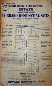
Plan - Subdivision Plan, Osburn Heights Estate, 1938
Edward Haughton & Co, in promoting the Osburn Heights Estate in what is now Balwyn North, attempted to capitalize on the subdivision’s proximity to East Kew. One section of the plan is includes the text: ‘The New Suburb: Camberwell North or East Kew (the names are synonymous)’. The Osburn Heights subdivision was part of a series of subdivisions running between Doncaster Road and Maud Street, including the ‘Pointed Firs Estate’ (MAP.0010). This subdivision included 13 ‘grand residential sites’ for sale in Doncaster Road, Maud Street and Osburn Avenue.subdivision plans - camberwell north, osburn heights estate -
University of Melbourne, Burnley Campus Archives
Plan, Joanne Woodhead, Garden Week 1987, 1987
Used by Honours student Linda Hipwell in 1999. This was held in Geoff Olive's office.Concept drawing by Joanne Woodhead. Given to Archives by Andrew Smith in 2010. joanne woodhead, linda hipwell, geoff olive, andrew smith -
Moorabbin Air Museum
Plan (item) - Bristol Aeroplane 170 schematic drawings, Mod - Pressure Head Auto Coarsening
Bristol Aeroplane Company Ltd -
Glen Eira Historical Society
Plan - North Road, 631, Ormond
Documents concerning valuations for mortgage on the house at 631 North Road Ormond. Includes letter requesting valuation from Union Trustee Co. of Australia Ltd to W.V. Scott from Mrs. L.E. Leahy’s loan dated 08/11/1955, valuation with detailed description and plan dated 17/11/1955. Also a valuation by W.V. Scott dated 06/03/1961 for Mrs. L.E. Leahy’s mortgage.ormond, north road, brick houses, leahy lucy e., wustemann-howgate a.e., ormond station, hore f.h., union trustee company of australia ltd., australian catholic assurance co., land values -
University of Melbourne, Burnley Campus Archives
Plan, Plan of Richmond Park, 1872
Plan of Richmond Park L4461. Shows Horticultural Society's Garden without extra land used for Field Station (see 11.0363, but earlier). Surveyed and drawn by A.L. Martin, Authorized Surveyor. Photo-lithographed at the Department of Lands and Survey, 6th Sept. 1872.Handwritten notes on reverse and another railway line marked in pencil.railway lines, swan street, yarra river, richmond park, horticultural society, orchard -
 Bendigo Historical Society Inc.
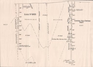
Plan - Mining Lease No. 10970, April, 2014
One page plan of Lease No. 10970, showing Napoleon Anticline and Central Nell Gwynne Shaft. Prepared by J. Caldwell, Mines Department Bendigo 6.2.1940.goldmining, quartz, mining, central nell gwynne gold mine, napoleon reef -
Moorabbin Air Museum
Plan (item) - Bristol Aeroplane 170 schematic drawings, Assembly of Auxiliary Control Box
Bristol Aeroplane Company Ltd -
Glenelg Shire Council Cultural Collection
Plan - Plans / Line Drawings - Port of Portland Authority Slipway Bilge Blocks, Wooden Vessel, Jane Kerr, victoria, 12/10/1982
PORT OF PORTLAND AUTHORITYFront: '8' - black texta, top right corner -
 Kew Historical Society Inc
Plan, Melbourne & Metropolitan Board of Works : Borough of Kew : Detail Plan No.1578, 1904
The Melbourne and Metropolitan Board of Works (MMBW) plans were produced from the 1890s to the 1950s. They were crucial to the design and development of Melbourne's sewerage and drainage system. The plans, at a scale of 40 feet to 1 inch (1:480), provide a detailed historical record of Melbourne streetscapes and environmental features. Each plan covers one or two street blocks (roughly six streets), showing details of buildings, including garden layouts and ownership boundaries, and features such as laneways, drains, bridges, parks, municipal boundaries and other prominent landmarks as they existed at the time each plan was produced. (Source: State Library of Victoria). This plan forms part of a large group of MMBW plans and maps that was donated to the Society by the Mr Poulter, City Engineer of the City of Kew in 1989. Within this collection, thirty-five hand-coloured plans, backed with linen, are of statewide significance as they include annotations that provide details of construction materials used in buildings in the first decade of the 20th century as well as additional information about land ownership and usage. The copies in the Public Record Office Victoria and the State Library of Victoria are monochrome versions which do not denote building materials so that the maps in this collection are invaluable and unique tools for researchers and heritage consultants. A number of the plans are not held in the collection of the State Library of Victoria so they have the additional attribute of rarity.Original survey plan, issued by the MMBW to a contractor with responsibility for constructing sewers in the area identified on the plan within the Borough of Kew. The plan was at some stage hand-coloured, possibly by the contractor, but more likely by officers working in the Engineering Department of the Borough and later Town, then City of Kew. The hand-coloured sections of buildings on the plan were used to denote masonry or brick constructions (pink), weatherboard constructions (yellow), and public buildings (grey). MMBW Plan No.1578 is significant in that it defines the extent of two private schools: Xavier College and Kew High School (now part of Trinity Grammar) by 1904. In relation to the latter, the plan clarifies which buildings the High School operated from behind the mansion ‘Molina’. Established in 1902, Trinity Grammar was to later lease and subsequently buy Molina (now ‘Merritt House’) and ‘Elsinore’ (now ‘Roberts House’). Xavier College had been established in 1872. This 1904 plan delineates the West Wing and the Great Hall (built in 1890).melbourne and metropolitan board of works, detail plans, maps - borough of kew, mmbw 1578, cartography -
University of Melbourne, Burnley Campus Archives
Plan, Nicole Faulkner, Rose Garden 'Banyule', 1989
Planting Plan for 'Banyule', 72 Buckingham Drive, Heidelberg by Nicole Faulkner for Grad. Dip. Horticulture. Sheet 4 of 4, dated November 1989. Scale 1:100.rose garden, nicole faulkner, "banyule", heidelberg -
 Vision Australia
Plan - Image, Conversion to Administrative offices / Conversion to Rehabilitation centre, 1 November 1962 - 5 April 1963
Over 1962-63, plans were drawn up for the conversion of the main building into administrative offices and a rehabilitation centre. As the children were now located at the school in Burwood, and with funds achieved from the sale of the old factory buildings to the Alfred Hospital, the St Kilda Road building could expand room for its office workers and provide greater floor space to rehabilitation staff. These plans show the proposed conversion from bedrooms to administrative and rehabilitation areas.7 architectural plans and 1 letterJohn F D Scarborough and Partners, Architectsroyal victorian institute for the blind, plans -
 University of Melbourne, Burnley Campus Archives
Plan, M. Drake et al, Incubator Building and Random Sample Laying Test Burnley Gardens - Site Location Plan, 1967
Plan by Public Works Dept., Melbourne. M. Drake (draughtsman), R. G. Wilson, Chief Architect.Copy 2 has some pencil additionsm. drake, g.r. wilson, burnley gardens, buildings, victoria public works department -
 Kew Historical Society Inc
Plan - Subdivision Plan, Wimba Estate, Kew, c.1925-c.1929, ca. 1925-ca. 1929
Pru Sanderson, in her groundbreaking ‘City of Kew Urban Conservation Study : Volume 2 - Development History’ (1988), summarised the periods of urban development and subdivisions of land in Kew. The periods that she identified included 1845-1880, 1880-1893, 1893-1921, 1921-1933, 1933-1943, and Post-War Development. These periods were selected as they represented periods of rapid growth or decline in urban development. An obvious starting point for Sanderson’s groupings involved population growth and the associated economic cycles. These cycles also highlighted urban expansion onto land that was predominantly rural, although in other cases it represented the decline and breakup of large estates. A number of the plans in the Kew Historical Society’s collection can also be found in other collections, such as those of the State Library of Victoria and the Boroondara Library Service. A number are however unique to the collection.Subdivision plans are historically important documents used as evidence of the growth of suburbs in Australia. They frequently provide information about when the land was sold on which a built structure was subsequently constructed as well as evidence relating to surveyors and real estate and financial agents. The numerous subdivision plans in the Kew Historical Society's collection represent working documents, ranging from the initial sketches made in planning a subdivision to printed plans on which auctioneers or agents listed the prices for which individual lots were sold. In a number of cases, the reverse of a subdivision plan in the collection includes a photograph of a house that was also for sale by the agent. These photographs provide significant heritage information relating house design and decoration, fencing and household gardens.In 1925, the City of Kew called for tenders for the construction of Wimba Avenue, Cadow Street and Lalla Street. Subsequent advertisements for the sale of land in Wimba Avenue continued from 1926 to 1929. The 18 lots (and a further five allotments on the eastern side of the street) offered for sale were unofficially described in the subdivision plan as the ‘Wimba Estate’. These lots began in Park Hill Road and extended almost to Cotham Road. The subdivision took its name from the house ‘Wimba’ in Cotham Road, which may have formed the southern boundary of the subdivision. (Wimba, at 235 Cotham Road was constructed between 1862-70). The Plan highlights the proximity and advantage of ‘electric’ trams in Cotham and Glenferrie Roads, and the Kew and Glenferrie Railway Stations. An oddity in the Plan is the reference to the electric tram terminus at Burke Road, given that the tramline had already been extended to Mont Albert in 1916.wimba estate, subdivision plans - kew, parkhill road – kew (vic.), normanby road – kew (vic.), wimba avenue – kew (vic.) -
 University of Melbourne, Burnley Campus Archives
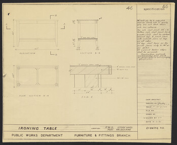
Plan, Specification - Ironing Table, 1960
Diagram of ironing table for P.W.D. Storeyard, Port Melbourne. No. 46 by Public Works Dept., Furniture & Fitting Branch. Redrawn by K.H.storeyard, ironing table, victoria public works department -
Moorabbin Air Museum
Plan (item) - Bristol Aeroplane 170 schematic drawings, Prop. Feathering - Repositioning of Pressure Cut Out Switch Port & Starboard
Bristol Aeroplane Company Ltd -
Port Melbourne Historical & Preservation Society
Plan - Proposed Bayside development, Aug 1987
SCDC plans for the Bayside development were revised as investigations into water circulation in artifical canals/harbour were completed. This is the plan as originally proposed prior to the EES hearing in September 1987.Large plan of original proposed Bayside development as submitted to council in 1987town planning - proposals shelved - bayside, sandridge city development co pty ltd, scdc -
Moorabbin Air Museum
Plan (item) - Bristol Aeroplane 170 schematic drawings, Auto Coarse Pitching Circuit Diagram
Bristol Aeroplane Company Ltd -
Port Melbourne Historical & Preservation Society
Plan - Metalling and channelling Clark Street from Graham Street to Poolman Street, Engineering Department, Town of Port Melbourne, 14 Mar 1893
Plan for metalling channelling Clark Street from Graham Street to Poolman Street Loan Works 1893; relates to specification 96.1Signed by JJ Bartlett (Mayor)engineering - roads streets lanes and footpaths, arthur victor heath, town clerks, james john bartlett, mayors -
 Bendigo Military Museum
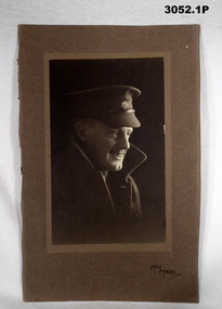
Plan - PHOTOGRAPHS AIF, 1) C. WW2, .2) C.WW1
Herbert Trangmar ALLAN. Refer to Cat No 2755.4 for his extensive service history and awards..1) Black & white head & shoulders portrait photo of an Australian Officer who is smiling. He is wearing a peaked cap with Rising Sun badge & a Great Coat with collars up. The photo is affixed to a substrate then a cardboard backing with a jagged edge on one side. .2) Black & white photo of two Australian Officers mounted on camels. Two native guides are also shown, behind are two pyramids & a sphinx..1) On front: “May Moore” On rear: “Herbert (Blue) Allan, Herbert Trangmar Allan (Blue) 1895 - 1967”portraits, photographs -
Federation University Historical Collection
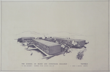
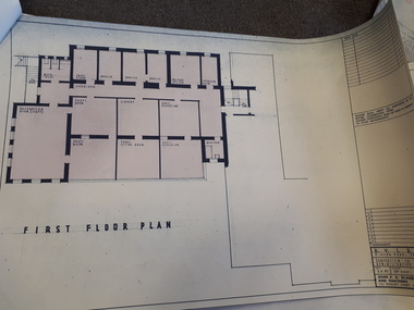
Plan, Preliminary Measured Drawing of the Former Gaol Governors Residence Lydiard Street, 1977, 28/06/1977
Plans showing the ground floor and first floor of the Ballarat School of Mines former Gaol Residence building. former gaol governor's residence, ballarat school of mines, former ballarat gaol, architectural drawing