Showing 90 items matching "ทวีตการรวบรวม Google(TG:e10838).gab"
-
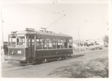 Ballarat Tramway Museum
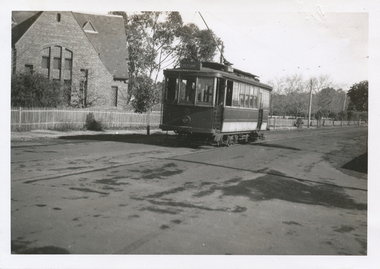
Photograph - Black & White Photograph/s, 1930's or early 1940's
Yields information about No. 28 late 1930's how the tram appeared at the time.Black and white photograph of Geelong No. 15, Birney, at the Eastern Park terminus, 1930's or 1940's? Tram has the destination of City. Photographer not known. The house behind the tram was able to be identified as 493 Ryrie St Geelong, shows up in Google Street View the verandah details. Two copies held.trams, tramways, geelong, eastern park, tram 15 -
 Melbourne Tram Museum
Pamphlet, Victorian Government and NTTData, "myki has gone mobile", Mar. 2019
Pamphlet - single DL printed on light card, titled "myki has gone mobile" advising passengers that Google Pay can be used on Android phone to pay for a Myki ticket.. Shows how this can be achieved and activated. Has logos for Victorian Government and NTTData. A web search showed that the date of introduction 28/3/2019.trams, tramways, myki, tickets, passengers -
 Melbourne Tram Museum
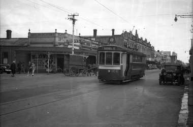
Negative, Wal Jack, 21/04/1945 12:00:00 AM
Black and white negative, by Wal Jack, of S 166 in Barkly St West Footscray, near intersection with Blandford St. returning to Footscray with an X1 at the end of the double track. The two church buildings were still there 9/2020 on Google Earth, but had a temporary fence in front of them. In the Wal Jack Melbourne album, the date is 21-4-1945.trams, tramways, russell st, barkly st, footscray, s class, tram 166, mmtb -
 Eltham District Historical Society Inc
Negative - Photograph, J.A. McDonald, Fordhams Road, Eltham, 24 July 1962
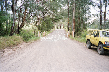
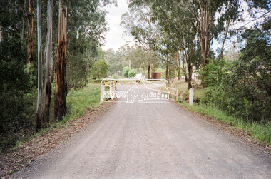
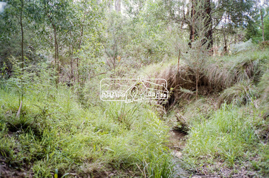
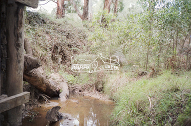
Culvert discharging towards land owned by Holloway & Spicer about 3pm on 24 July 1962 Heavy rain 60 years later it still appears to present as a concern - see Google Street View (Nov 2021) https://goo.gl/maps/x61yWvAc5UjJ2d8y9Record of various Shire of Eltham infrastructure works undertaken during the period of 1952-1962 involving bridge and road reconstruction projects, sometimes with Eltham Shire Council Project Reference numbers quoted. It was during this period that a number of significant improvements were made to roads and new bridges constructed within the shire that remain in place as of present day (2022). In many situations, the photos provide a tangible visible record of infrastructure that existed throughout the early days of the Shire. The album was put together by or under the direction of the Shire Engineer, J.A. McDonald.1962-07-24, culvert, eltham, fordhams road, infrastructure, shire of eltham -
 Eltham District Historical Society Inc
Negative - Photograph, J.A. McDonald, Fordhams Road, Eltham, 24 July 1962
Culvert discharging towards land owned by Holloway & Spicer about 3pm on 24 July 1962 Heavy rain 60 years later it still appears to present as a concern - see Google Street View (Nov 2021) https://goo.gl/maps/x61yWvAc5UjJ2d8y9Record of various Shire of Eltham infrastructure works undertaken during the period of 1952-1962 involving bridge and road reconstruction projects, sometimes with Eltham Shire Council Project Reference numbers quoted. It was during this period that a number of significant improvements were made to roads and new bridges constructed within the shire that remain in place as of present day (2022). In many situations, the photos provide a tangible visible record of infrastructure that existed throughout the early days of the Shire. The album was put together by or under the direction of the Shire Engineer, J.A. McDonald.1962-07-24, culvert, eltham, fordhams road, infrastructure, shire of eltham -
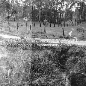
 Eltham District Historical Society Inc
Negative - Photograph, Cottlesbridge-Strathewen Road, Strathewen, c.Nov. 1987
Photos taken during a review of road and bridge/culvert condition by Eltham Shire Council engineers. A number of the trees were badly burnt or destroyed in the Black Saturday bushfire, 7 Feb. 2009 but some remained standing and identifiable as of 2014 (Google Streetview).Roll of 35mm colour negative film, 4 stripsKodak GB 200 5096bridge, chads creek, chads creek road, cottlesbridge-strathewen road, culvert, infrastructure, roads, school ridge road, strathewen -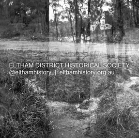
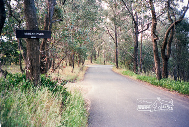 Eltham District Historical Society Inc
Photograph, Ardean Park, 315 Flat Rock Rd, Hurstbridge
Sold by Fletchers 3 Dec 2015 for $1.26m. See https://www.realestate.com.au/sold/property-house-vic-hurstbridge-121193850 Google Streetview Feb 2014 https://www.google.com.au/maps/@-37.6455525,145.2071828,3a,49.4y,333.82h,88.64t/data=!3m6!1e1!3m4!1sr2PfMo3UeXV_fqSDYToiuA!2e0!7i13312!8i6656Roll of 35mm colour negative film, 2 stripsKodak GA 100 5095shire of eltham, roads, flatrock road, hurstbridge, ardean park, cowan -
 Eltham District Historical Society Inc
Negative - Photograph, J.A. McDonald, Sherbourne Road, Montmorency, c. July 1962
View looking west across Sherbourne Road to intersection of Rattray Road from present-day forecourt entrance to 7-Eleven Eltham service station The BP Service Station is now an Ampol Service Station (2022) Google Street View Apr.. 2022 https://goo.gl/maps/LM4APKCwj1ohBDPv5Record of various Shire of Eltham infrastructure works undertaken during the period of 1952-1962 involving bridge and road reconstruction projects, sometimes with Eltham Shire Council Project Reference numbers quoted. It was during this period that a number of significant improvements were made to roads and new bridges constructed within the shire that remain in place as of present day (2022). In many situations, the photos provide a tangible visible record of infrastructure that existed throughout the early days of the Shire. The album was put together by or under the direction of the Shire Engineer, J.A. McDonald.1962-07, ampol service station, bp service station, montmorency, rattray road, service station, sherbourne road, graders, infrastructure, public telephone box (red), reconstruction works, road construction, shire of eltham -
 Eltham District Historical Society Inc
Negative - Photograph, J.A. McDonald, Sherbourne Road, Montmorency, c. July 1962
View looking west across Sherbourne Road to intersection of Rattray Road from present-day forecourt entrance to 7-Eleven Eltham service station The BP Service Station is now an Ampol Service Station (2022) Google Street View Apr.. 2022 https://goo.gl/maps/LM4APKCwj1ohBDPv5Record of various Shire of Eltham infrastructure works undertaken during the period of 1952-1962 involving bridge and road reconstruction projects, sometimes with Eltham Shire Council Project Reference numbers quoted. It was during this period that a number of significant improvements were made to roads and new bridges constructed within the shire that remain in place as of present day (2022). In many situations, the photos provide a tangible visible record of infrastructure that existed throughout the early days of the Shire. The album was put together by or under the direction of the Shire Engineer, J.A. McDonald.1962-07, ampol service station, bp service station, montmorency, rattray road, service station, sherbourne road, infrastructure, reconstruction works, road construction, shire of eltham -
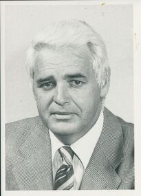 Uniting Church Archives - Synod of Victoria
Photograph, 1987
Peter Cole-Adams was Associate Editor of The Age. No other biographical details are available, but his writings are recorded and can be accessed through Google. The C&N article was about a speech he gave entitled "Publish and be damned" at Mt Eliza UC's annual community lecture (which is produced in full).B & W head and shoulders photograph of Peter Cole-Adams. "Peter Cole-Adams"peter cole-adams, the age newspaper -
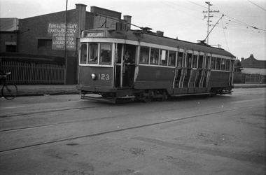 Melbourne Tram Museum
Negative, Wal Jack collection, 24/11/1941 12:00:00 AM
Black and white negative by Wal Jack of Maximum Traction N 123 (Moreland) in Nicholson St after running out of the Coburg Tram Depot. The shop in the background selling Confectionery etc is the Pause Cafe (Google Earth - 20-10-2020) Photo dated, 24/11/1941 in the Wal Jack album. See also Reg Item 5329 to 5332 for other photos featuring this tram.trams, tramways, n class, coburg depot, coburg, moreland, nicholson st, tram 123 -
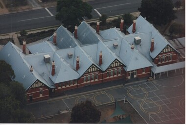 Rutherglen Historical Society
Photograph - Aerial Images, c2000
Photograph was probably taken sometime before 2007, as another photo in this series does not show the "Big Red Shed" behind the school. That building is shown on Google Street View shots taken in 2007. Rutherglen Common School No. 522, which is now the Common School Museum, would be to the left of the current school in the photo.Colour aerial photograph of Rutherglen Primary School No. 522, showing the rear of the building and its rooftop.rutherglen primary school, rutherglen state school, school buildings -
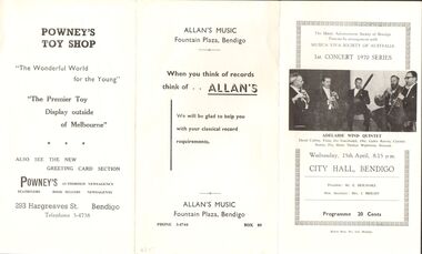 Bendigo Historical Society Inc.
Document - ADELAIDE WIND QUARTET, CITY HALL, BENDIGO, 15 April, 1970
The Music Advancement Society of Bendigo Presents by arrangement with Musica Viva Society of Australia 1st Concert 1970 Series 'Adelaide Wind Quartet' David Cubbin, Flute; Jiri Tancibudek, Obe; Gabor Reeves, Clarinet; Stanley Fry, Horn; Thomas Wightman, Bassoon. Wednesday, 15th April, 8.15pm, City Hall, Bendigo. President: Mr E Beilharz, Hon. Secretary: Mrs. J Bright. Programme 20 Cents. Advertisements: The Brolga Hotel - Motel. Powney's Toy Shop & Newsagency, Allan's Music,Bolton Bros. Pty. Ltd. Bendigoentertainment, theatre, music advancement society of bendig, the music advancement society of bendigo presents by arrangement with musica viva society of australia 1st concert 1970 series 'adelaide wind quartet' david cubbin, flute; jiri tancibudek, obe; gabor reeves, clarinet; stanley fry, horn; thomas wightman, bassoon. wednesday, 15th april, 8.15pm, city hall, bendigo. president: mr e beilharz, hon. secretary: mrs. j bright. programme. advertisements: the brolga hotel - motel. powney's toy shop & newsagency, allan's music -
 Glen Eira Historical Society
Document - Caulfield, John
Four items about a third John Caulfield. Handwritten research on John Caulfield by Garryowen p662, undated and unsigned. Handwritten research on “Garryowen”- Edmund Finn from ‘Google’. Handwritten notes from Melbourne Benevolent Society showing admission application for John Caulfield and Hannah Caulfield. Photocopy of deaths register No. 149895 in the district of West Hotham for Caulfield, John.caulfield john, ‘garryowen’, finn edmund, deaths registers, melbourne benevolent society, caulfield catherine, caulfield hannah -
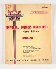 City of Greater Bendigo - Civic Collection
Book, Universal Business Directories, Universal Business Directory for Bendigo, c 1950
Business Directories such as this were common right up until the widespread use of the internet and search engines such as Google to find information. Universal Business Directories were a company which sought advertisers from local areas to offset the cost of producing the directories. This directory includes a history of Bendigo, map and recipes as well as extensive listings for local business, trades and services. 50 page, three colour commercially printed business directory designed to by hung beside the telephone. Includes advertising and listings for a wide variety of local businesses. Includes a page of recipes and information for emergency services. city of bendigo, city of bendigo commerce -
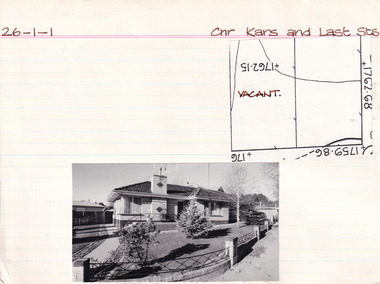 The Beechworth Burke Museum Research Collection
Card (Series) - Index Card, George Tibbits, Cnr Kars & Last Streets, Beechworth, 1976
George Tibbits, University of Melbourne. Faculty of Architecture, Building and Town & Regional PlanningIndex system that support the research for Beechworth : historical reconstruction / [by] George Tibbits ... [et al]Arranged by street names of BeechworthEach index card includes: street name and number of property, image of property, allotment and section number, property owners and dates of ownership, description of the property according to rate records, property floor plan with dimensions.beechworth, george tibbitsbeechworth, george tibbits -
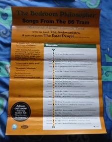 Melbourne Tram Museum
Poster, The Bedroom Philosopher, David Blumenstein, "The Bedroom Philosopher - songs from the 86 Tram", c2010
Full colour poster, titled "The Bedroom Philosopher - songs from the 86 Tram" giving dates for a show and album launch. National album launch tour - with his band The Awkwardstra. Has locations, dates, support bands and reviews. See Reg Item 1289 for the CD and 1624 for an article on the CD. Cartoon - digital image - by David Blumenstein - Nakedfella Productions added 12-6-2016, accessed from google. His website at 12/6/17 - http://nakedfella.com/blog/trams, tramways, route 86, theatre, music, northcote, cartoons -
 Eltham District Historical Society Inc
Folder, Shire of Eltham War Memorial, Kangaroo Ground
Contents 1. Google earth images of Tower 2. Extract describing history of Tower, including honour roll for WW1 and WW2, 8 pages 3. Extract describing history of Tower, including honour roll for WW1 and WW2, 3 pages 4. 2002 and 2004; Kangaroo Ground Tower; Southwell-Keely M.; WAR MEMORIALS IN AUSTRALIA; 8 pages, (http://www.skp.com.au/memorials/pages/30054.htm)Folder/Booklet of various documents, mainly A4 size photocopiesHG Booklet 1harry gilham collection, kangaroo ground, ww1, ww2, war memorial tower, kangaroo ground tower, memorial, tower -
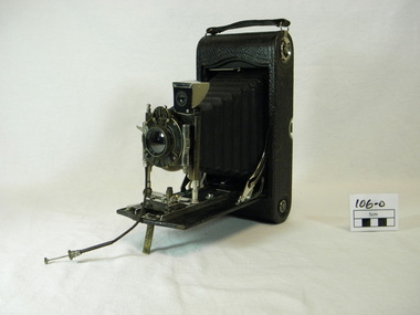 Hamilton Pastoral Museum
camera, Eastman Kodak, 1907
Google kodak manufactured from about 1900 to today No. 3 Cartridge KODAK Camera (metal front slide block focus) (Improved metal front, bed extension, longer bellow and rack pinion focus 1901) This item recorded pictorial information on the life and times of our society. advertising ,social events, news items ,scientific work, engineering ,medical field ,agriculture ,fires , famine, floods ,droughtkodak film camera. Leather look case, lens assembly with cable release folds out of case with expandable concertina lens.Name plate printed on assembly lens "EASTMAN KODAK / COMPANY/ ROCHESTER U.S.A." Printed on top of lens "KODAK / PAT / MAY 7 / 1907 / AUTOMATIC"pictorial, information, 1907, camera, kodak -
Glen Eira Historical Society
Article - GLEN EIRA ROAD, 258, ELSTERNWICK, E. K. MOTORS
This file contains 3 items: 1/Two page printout taken from Google, March 2012, includes colour photo of garage, history of site, building style and former owner of garage, and properties included in the development. 2/Newspaper article dated 19/04/15 on Glover Station, now turned into a ‘bright and airy café’. 3/Printed details from Carol Stals about owner, Eitan Klein.cafes, restaurants, hospitality establishments, ‘glovers station’, tudor service station, service stations, english domestic revival style, ‘glover service station’, commercial development, cuthbertson sarah, elizabeth street, warburton annie, glen eira road, orrong road, cuthbertson eric s., hall james, grazier, swinnerton heolley fraser, glover robert, klein e. k. -
 Melbourne Tram Museum
Document - Report, David Frost, Sale of 33 Fifth St Black Rock - tram shed
Documents related to the sale of 33 Fifth Street Black Rock, including two colour photocopies with the external and internal views of a shed said to be a former tram shed associated with the Sandringham to Black Rock horse tram line. Includes the City of Bayside heritage report and Hocking Stuart sales sheets for an auction on Saturday 4 August 2007. It would appear from Google Earth that all buildings were demolished.Yields information about the sale of a property said to be associated with the Black Rock tramway.Four A4 sheets - two colour and one colour sheet providing auction details.trams, railways, vr trams, sandringham, black rock tramway, sale of land, 33 fifth st black rock -
 Eltham District Historical Society Inc
Negative - Photograph, J.A. McDonald, Eltham, Haldane Road, Mar. 1961
Dr Donald Thomson's gate and entrance to his property 'Worlingworth' after flooding in March 1961 "Worlingworth", Eltham, was the home of noted anthropologist the late Professor Donald Thomson and his wife Dorita. The entrance gate on Banoon Road is located at the bottom of the hill opposite Haldane Road. The flooding issues were regularly reported to Council following heavy rain. Google Street View Feb 2014 https://goo.gl/maps/SGjsJAAEdjQXgo5V9Record of various Shire of Eltham infrastructure works undertaken during the period of 1952-1962 involving bridge and road reconstruction projects, sometimes with Eltham Shire Council Project Reference numbers quoted. It was during this period that a number of significant improvements were made to roads and new bridges constructed within the shire that remain in place as of present day (2022). In many situations, the photos provide a tangible visible record of infrastructure that existed throughout the early days of the Shire. The album was put together by or under the direction of the Shire Engineer, J.A. McDonald.infrastructure, shire of eltham, 1961-03, flood damage, haldane road, prof donald thomson, worlingworth -
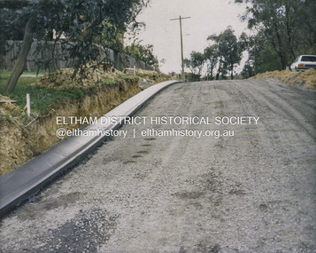 Eltham District Historical Society Inc
Photograph - Colour Print, Shire of Eltham, Bolton Street, Eltham, just north of Sackville Street intersection, c.1983
A single rollover kerb has just been laid on western side cut into the embankment. At the crest of the hill on right in front of the Ford Laser is a fire hyrdant. This photo was processed at the same time as image EDHS_07261 of roadworks in Sackville Street about 200 m away which has been dated as c.1983 (between Sep 1982 and May 1983). The paling fence on the left has a change of angle just before the crest of the hill then flattens. More recent Google Streetviews show the same fence and shape and in more recent times a new fence but same shape. Google Streetview for Jan 2008 indicates a more recent road widening and new profile kerb and channel. The embankment was further cut away and the footpath that was adjacent to the fence lowered to road level. The fire hydrant that was on the right hand side has been relocated to the left next to the footpath. Significantly more electrical wires are now strung on the telephone poles. In 2017 Bolton Street was again upgraded. The fire hyrdrant was then relocated to another (unknown) location.1983, footpaths and gutters, road construction, road drainage, road sealing, bolton street, eltham, sackville street -
 Ballarat Tramway Museum
Photograph - Black & White Photograph/s, Wal Jack, 23/06/1949 12:00:00 AM
Black and White print contained within the Wal Jack Bendigo and Geelong Album, see Reg Item 5003 for more details. Photo of Geelong No. 8 to Newtown, in Aphrasia St at Talbot St. Newtown. Photo by Wal Jack 23-6-1949. Tram has the destination of Newtown. Has a church in the background - possibly now part of the Geelong College - (Google Earth) i1 - scan of print in the album i2 - rear of image i3 - scan of negative at 3200dpi added 18/6/2020. On rear in ink "SEC Geelong No. 8 to Newtown in Aphrasia St from Talbot St. 11.31am Newtown 23-6-49" Has the Wal Jack copyright stamp in the top right hand corner with the number "T284" written in.., Negs contained within a shoe box received from Keith Kings.trams, tramways, geelong, newtown, aphrasia st, tram 8 -
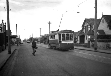
 Melbourne Tram Museum
Negative, Wal Jack, c1943-44
Black and white negative, by Wal Jack, of S class 166 (showing Russell St), in Barkly St Footscray. Based on the photograph, the tram is inbound to Footscray Station, as the buildings match the current (12/2020) Google Earth view at 185 Barkly St and Albert St. In the background is - Brown's Dry cleaner, a Millinery shop at 185, W. Adler Tailor, J. Paarons PA (Radio) on the clockface and H E M Burrow? store sign. A horse drawn van is alongside the tram. Photo undated, c1943-44trams, tramways, barkly st, footscray, russell st, s class, tram 166, mmtb -
 Glen Eira Historical Society
Photograph - Hawthorn Road, 342, Caulfield
Two items about this address: 1/Two colour photos of a commercial building under construction on Hawthorn Road in September 1987. Building is south of Glenhuntly Road on western side And was being built for Caulfield City Council. 2/Print of comment entered 03/03/2019 on Victorian Collections website for this file from reader Angus giving street number as '342'. Google map photo print done 04/04/2019 confirms this.hawthorn road, caulfield, caulfield city council, commercial buildings, council buildings