Showing 125 items matching " argyle."
-
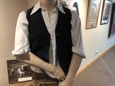 Mont De Lancey
Mens Shirt, Circa 1940
Typical fruit picking attire.White cotton Argyle brand, half opening shirt, with 2 buttons.Previously used by Museum Sub-Committee in their display.shirts -
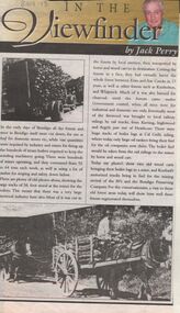 Bendigo Historical Society Inc.
Newspaper - JACK PERRY COLLECTION: NEWSPAPERFIREWOOD INDUSTRY
... Argyle. ...Newspaper article, Bendigo Weekly, re firewood industry and use of wood in mines. Mentions Emu and Axe Creek, Kimbolton, Whipstick areas. Charcoal burners. Kurting, Inglewood and Argyle areas , Heathcote and railway sidings. Koefeds and Bendigo Preserving Company are companies mentioned . Image shows Koefeds motorised truck bringing in wood - also horse and cart loaded with wood. ( poor quality )person, individual, jack perry, heathcote, california gully, axe and emu creeks, kimbolton, whipstick, charcoal, kurtging, inglewood, argyle. -
 Linton and District Historical Society Inc
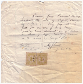
Receipt, Receipt for Payment for a Block of Land near Linton, 1918
Note that the block of land which was traded was not the block in Sussex Street, Linton on which the Sandows had a shop and house, but a block just outside the town boundary, near the Geelong Road (Linton-Naringhil Road). See map of Parish of Argyle for clarification.Photocopy of original handwritten receipt, which was for payment in full for a block of land situated just outside of Linton - Section A, Crown Allotment 1, Parish of Argyle. This land was purchased by Rubina (Ruby) Sandow from George Bolte in 1918. Receipt is for fifteen pounds, it is made out to "Rubinia Norwood Sandow" and is signed by Alf J. Smith, "for Geo. Bolte". Two Victorian Stamp Duty stamps are attached to the original document.rubina (ruby) sandow, george bolte, receipts, sale of land -
 Linton and District Historical Society Inc
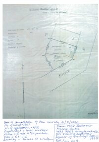
Mining survey document, Mining Survey Document, 1890
Document drawn up in relation to an application for a mining lease made by Isaac Walker of Linton. Application no. PP16, Lease no. 1351. Application was made for a mining lease on land in Sussex Street, Linton, which was occupied by Sarah Dawe and family. Original document is held at PROV Ballarat. Item and series details are recorded in handwriting on the lower part of the document.Photocopy of original document, which shows a plan of Allotments 3 & 4, Section 1A, Township of Linton, Parish of Argyle.mining applications, mining leases, plans, documents, isaac walker, dawe family, sarah dawe née carpenter -
 Whitehorse Historical Society Inc.
Newspaper - Article, Historic homestead, 1/03/2000
Property advertisement for 3 bedroom Edwardian timber house at 17-21 Junction Road, Blackburn North, for auction on 11 March 2000. Agent: Argyle Partners.junction road, blackburn north, no 17 - 21., argyle partners, auctions -
 Kew Historical Society Inc
Plan - Subdivision Plan, Lodged Plan No.6518, 1920-1940
The Kew Historical Society collection includes almost 100 subdivision plans pertaining to suburbs of the City of Melbourne. Most of these are of Kew, Kew East or Studley Park, although a smaller number are plans of Camberwell, Deepdene, Balwyn and Hawthorn. It is believed that the majority of the plans were gifted to the Society by persons connected with the real estate firm - J. R. Mathers and McMillan, 136 Cotham Road, Kew. The Plans in the collection are rarely in pristine form, being working plans on which the agent would write notes and record lots sold and the prices of these. The subdivision plans are historically significant examples of the growth of urban Melbourne from the beginning of the 20th Century up until the 1980s. A number of the plans are double-sided and often include a photograph on the reverse. Reconciling this hand-drawn subdivision plan with a modern map of the area is initially a challenge due to a change of street names. Argyle Road in the centre of the subdivision was to be renamed Deepdene Road, and the street named Deepdene Road on the plan was to become Deepdene Place. Of interest is the nursery on the corner of Argyle and Whitehorse Roads. During this period there were a number of nurseries servicing the Kew and Balwyn areas. The subdivision was essentially of the land formerly occupied by the house 'Deepdene'.subdivision plans - balwyn, deepdene, whitehorse road -- deepdene (vic.), deepdene road -- deepdene (vic.), burke road -- deepdene (vic.) -
Glenelg Shire Council Cultural Collection
Administrative record - Account rendered from Chas. Teague, baker, pastry cook and confectioner, of the Argyle Bakery, Julia St. Portland, 30/04/1898
Account rendered from Chas. Teague, baker, pastry cook and confectioner, of the Argyle Bakery, Julia St. Portland to M.E. Adams, in the sum of £4.4.10. Printed form, details handwritten. -
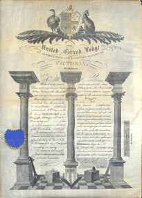 Ringwood and District Historical Society
Certificate, United Grand Lodge of Victoria Membership - Collection of Masonic Degrees and Correspondence maintained by Aird family of Ringwood, Victoria
Certification that Brother John Ashworth Daniell was regularly received into the Free Masonry on 11th June AL5906 and was admitted to the 3rd Degree on 3rd September, 1906, in the Argyle Lodge No.105, Traralgon. -
Whitehorse Historical Society Inc.
Newspaper - Article, The Rambling rose of Vermont, 1/06/1998
Article in the Age property section by Warren Selle giving his opinion on improving the Californian Bungalow at 16 Grove Street Vermont which is to be auctioned by Argyle Partners on 11 July 1998. The property is expected to fetch $400,000. Photograph, Diagramsauctions, grove street, vermont no 16, argyle partners -
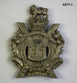 Bendigo Military Museum
Badge - BADGES, BRITISH COLLECTION, 1930 - 45
Items in the collection re Ian McLeod RWAFF, refer Cat No 2262.2 for service details..1) Badge, pressed metal, silver colour, loin crown, scrolls, wreath "Kings own Scottish Borderers" .2) Badge, pressed metal, silver colour, wreath, crown scrolls "Argyle and Sutherland" .3) Badge, pressed blackened metal, crown, wreath and scrolls "Royal Engineers".badges, british, collection -
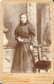 Bendigo Historical Society Inc.
Photograph - FEMALE PORTRAIT, Ca 1900
sepia photograph on fawn board. Studio portrait of young woman standing beside chair. Young woman, long hair, leg of mutton sleeves. Holding book. Written on back of photo: Kate in black ink. Turnbull & Sons, Artistic Photographer, 10 Jamaica St, corner of Argyle Street, Glasgow.Turnbull & sons, Glasgow, Greenock, Kilmarnock and Belfastperson, individual, portrait female -
Bendigo Historical Society Inc.
Map - HEATHCOTE : COUNTY OF BENDIGO, 11-4-35
Map. Heathcote, County of Bendigo, County of Dalhousie,Township of Heathcote, McIvor Creek, Argyle Station Ground, Wallan and Bendigo Railway, C.R.B. Main Road. By authority H.J. Green, Govt. Printer. Photo-Lithographed at the Department of Lands and Survey, Melbourne. 11-4-35. Price 2/-. (number 88 in map cupboard 1)H.J. Green, Govt.Printermap, bendigo, heathcote -
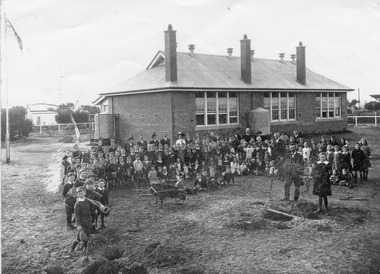 Chelsea & District Historical Society Inc
Photograph - Chelsea State School, Children and teachers in the yard of the school grounds, 1916
Chelsea State School was built on Argyle Avenue and officially opened on 27 January 1915.Black and white photo of children and teachers in the yard of Chelsea State School, in 1916. Some Children are carrying gardening tools. chelsea, education, chelsea primary school, school, students, school yard, chelsea state school -
 Chelsea & District Historical Society Inc
Photograph - Chelsea State School, Group of girls, 1917
Chelsea State School was built on Argyle Avenue and officially opened on 27 January 1915.Sepia photo of girls at Chelsea State School, in 1917. Some of the girls are holding "Cupie Dolls"chelsea, education, chelsea primary school, school, chelsea state school, cupie dolls -
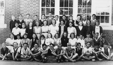
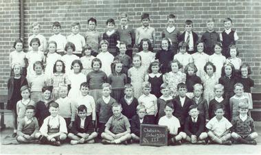
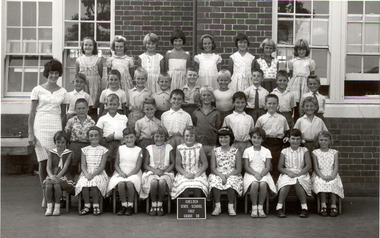
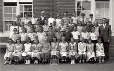 Chelsea & District Historical Society Inc
Photograph - Chelsea State School, Grade 6B, 1962
Chelsea State School was built on Argyle Avenue and officially opened on 27 January 1915.Black and white photo of Grade 6B at Chelsea State School, in 1962chelsea, education, chelsea primary school, school, grade 6b, chelsea state school -
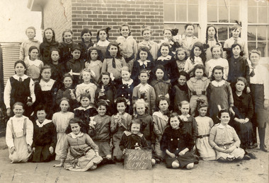
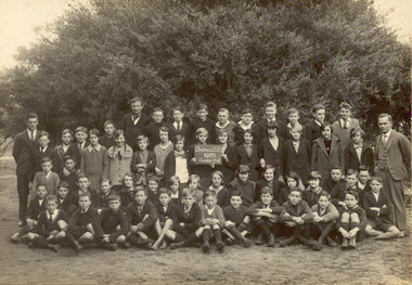
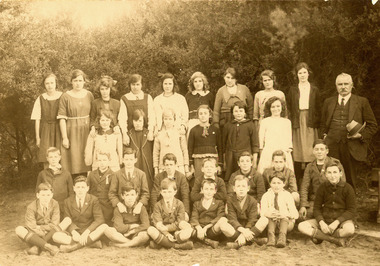
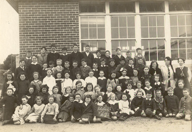
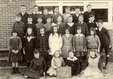 Chelsea & District Historical Society Inc
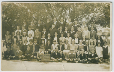
Photograph - Chelsea State School, Grade V, 4 August 1918
Chelsea State School was built on Argyle Avenue and officially opened on 27 January 1915.Black and white photo of Grades V at Chelsea State School, on 14 August 1918 Back row: John Mullins, Charles Thibou, Leslie Payne, unknown, Lindsay Mercer, Tom Johnston, George Shillinglaw 2nd row: Roy O'Donnell, James Turner, Albert Thibou, Cecil Sandford, George Curl, Alfred Brain, Ernest Capp, Roy Porter, Cyril Ashmore 3rd row: Stella Staff, Mary Harkins, Lesley Green, Rose Hunter, Olive James, Hazel Allen, Florence Scott Sitting: Myrtle Barfoot, Jean Ambrose, Una Charman, Rita Ludford chelsea, education, chelsea primary school, school, chelsea state school, grade v -
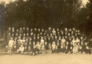
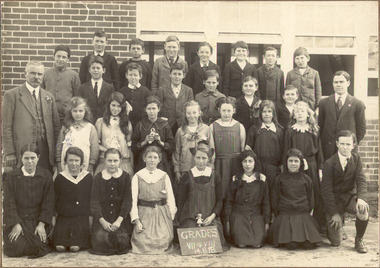 Chelsea & District Historical Society Inc
Photograph - Chelsea State School, Grade VII & VIII, 4 August 1918
Chelsea State School was built on Argyle Avenue and officially opened on 27 January 1915.Black and white photo of Mr G. Rogers, the Head Teacher, a male teacher, GradesVII and VIII at Chelsea State School, on 14 August 1918chelsea, education, chelsea primary school, school, chelsea state school, grade 7, grade 8 -
 Chelsea & District Historical Society Inc
Photograph - Chelsea State School, Grade 7 & 8, 1928
Chelsea State School was built on Argyle Avenue and officially opened on 27 January 1915.Black and white photo of Grades 7 and 8 at Chelsea State School, in 1928chelsea, education, chelsea primary school, school, chelsea state school, grade 7, grade 8 -
 Chelsea & District Historical Society Inc
Photograph - Chelsea State School, Grade 3, c 1920's
Chelsea State School was built on Argyle Avenue and officially opened on 27 January 1915.Sepia photo of Grade 3 at Chelsea State School. chelsea, education, chelsea primary school, school, chelsea state school, grade 3 -
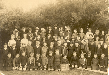 Chelsea & District Historical Society Inc
Photograph - Chelsea State School, Grades II & Ic, 13 June 1922
Chelsea State School was built on Argyle Avenue and officially opened on 27 January 1915.Sepia photo of Grade II and Ic children at Chelsea State School, in 1922chelsea, education, chelsea primary school, school, grade 7 & 8 -
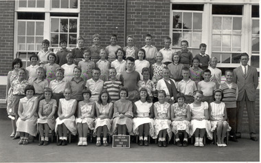
 Chelsea & District Historical Society Inc
Photograph - Chelsea State School, Grade 7 & 8, 1950
Chelsea State School was built on Argyle Avenue and officially opened on 27 January 1915.Black and white photo of Grade 7 & 8 children at Chelsea State School, in 1956chelsea, education, chelsea primary school, school, grade 7 & 8 -
 Chelsea & District Historical Society Inc
Photograph - Chelsea State School, Grade 3, 1941
Chelsea State School was built on Argyle Avenue and officially opened on 27 January 1915.Black and white photo of Grade 3 children at Chelsea State School, in 1941chelsea, education, chelsea primary school, school, grade 7 & 8 -
 Chelsea & District Historical Society Inc
Photograph - Chelsea State School, Grade 6A, 1962
Chelsea State School was built on Argyle Avenue and officially opened on 27 January 1915.Black and White photo of Grade 6A at Chelsea State School, in 1962chelsea, education, chelsea primary school, school, grade 6a, chelsea state school -
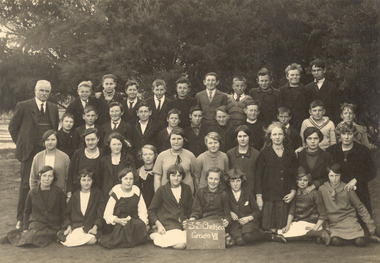
 Chelsea & District Historical Society Inc
Photograph - Chelsea State School, Grade 8, 1921-22
Chelsea State School was built on Argyle Avenue and officially opened on 27 January 1915.Black and white photo of Mr G. Rogers, the Head Teacher, Grades 8 at Chelsea State School, 1921-22 Back row: Hazel Allen, Joyce Davis, Dorothy Craven, Lesley Green, Myrtle Willis, Vera Halford, Dorothy Dixie, Ivy Timewell, Una Charman, Mr G Rogers (Head Teacher) 2nd row: Florence Scott, Enid Carter, Ella Hawke, Phyllis Edhouse, Dorothy Stokes, Vera James 3rd row: - Brain, Fred Judd, Harry Blan, - Rogers, Tom Bickley, Bob Loveless, unknown, Charles McFarlane Front row: Alex Elder, James Turner, Bob Staff, Ray Jackson, Jack Johnston, Cliff Cumming, unknown, unknown chelsea, education, chelsea primary school, school, chelsea state school, grade 8, g rogers -
 Chelsea & District Historical Society Inc
Photograph - Chelsea State School, Grade VII, 1920's
Chelsea State School was built on Argyle Avenue and officially opened on 27 January 1915.Sepia photo of Grade ViII with a Mr Rogers, Head Teacher at Chelsea State School.chelsea, education, chelsea primary school, school, chelsea state school, grade vii, mr rogers -
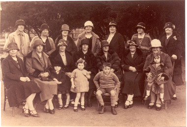 Chelsea & District Historical Society Inc
Photograph - Chelsea State School, Mothers and small children, 1922
Chelsea State School was built on Argyle Avenue and officially opened on 27 January 1915.Sepia photo of the mother's club and their small children at Chelsea State School. Two people have been identified: Mrs Potter (back row 2nd left) Mrs Touzel (back row 4th left)chelsea, education, chelsea primary school, school, chelsea state school, mothers club -
 Chelsea & District Historical Society Inc
Photograph - Chelsea State School, Grades 3 and 4, 1917
Chelsea State School was built on Argyle Avenue and officially opened on 27 January 1915.Sepia photo of Grades 3 and 4 with two female teachers at Chelsea State School.chelsea, education, chelsea primary school, school, chelsea state school, grade 3, grade 4 -
 Chelsea & District Historical Society Inc
Photograph - Chelsea State School, Grade 3B, 1962
Chelsea State School was built on Argyle Avenue and officially opened on 27 January 1915.black and white photo of Grade 3B and a female teacher at Chelsea State School.chelsea, education, chelsea primary school, school, chelsea state school, grade 3b -
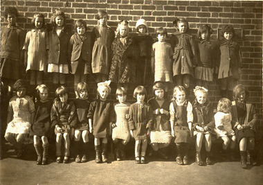 Chelsea & District Historical Society Inc
Photograph - Chelsea State School, A group of young girls, 1917
Chelsea State School was built on Argyle Avenue and officially opened on 27 January 1915.Sepia photo of young girls at Chelsea State School.chelsea, education, chelsea primary school, school, chelsea state school, young girls -
 Chelsea & District Historical Society Inc
Photograph - Chelsea State School, Grades VII and VIII, c. 1920's
Chelsea State School was built on Argyle Avenue and officially opened on 27 January 1915.Sepia photo Grades VII and VIII, Chelsea State School, in 1920's. chelsea, education, chelsea primary school, school, chelsea state school