Showing 42 items
matching camp reserve. bendigo.
-
 Bendigo Historical Society Inc.
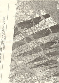
Map - LONG GULLY HISTORY GROUP COLLECTION: BENDIGO GOLD FIELD - GOLDEN SQUARE GEOLOGICAL SURVEY OF VICTORIA
BHS CollectionPart of a map of the Bendigo Gold Field - Golden Square. Geological Survey of Victoria. Shown are reefs, faults and anticlines. Many of the mines are shown on the map. Gullies, hills and streets are also shown.bendigo, history, long gully history group, the long gully history group - bendigo gold field - golden square geological survey of victoria, north bendigo state school reserve, hospital reserve, benevolent asylum reserve, empire hill, richmond hill, raes hill, south end hill, victoria hill, new chum hill, iron bark hill, redan hill, view hill, hustlers hill, camp hill -
 Bendigo Historical Society Inc.
Document - SPECIMEN COTTAGE COLLECTION: VARIOUS DOCUMENTS
Various documents in plastic folders. The topics are: 1. The Myer story - articles on the history of the Myer family and business. 2. The history of the Bendigo Railway and memoirs of early train travel by Bob Carr. 3. Victorian history of railway and Bendigo, linking a state. 4. A brief history of steam locomotives R711 and R766. 5. Bendigo Advertiser article: coming of the railway with 4 photos. 6. Celebrating 150 years of rail in Bendigo brochure plus postcard and Bendigo Railway Museum newsletter. 7. Phoenix FM radio interview 13th September 2011. interviewer John Hall, guest: Garry Long, Convenor friends of the Bendigo-Kilmore rail trail. 8. Mail by rail by Tom Luke and Railway history Leo Hogan. 9. Document on the Red Ribbon Movement. 10. Document - Sport in Bendigo in the early days. 11. History of the Girton Church of England Girls' Grammar School with a list of prominent students. 12. Bendigo's loss-Chinese secret society's gain? Talk given by Carol Holsworth. 13. Document - Bendigo in the fifties. 14. Jones, Miller & Co. history. 15. Transcript of an audio tape by Cyril Michelsen, black and white photo and newspaper article. 16. A garden history by Ken Maes. 17. Document - Marsh and Scholten Coach builders. 18. Notes from the diary of Thomas Ninnes, newspaper articles on the restoration of the Ninnes grave. 19. Sandhurst 1853-54 The Southern world Rev. Robert Young. 20. Correspondence from Cobb & Co. Royal Flying Doctor Service 1963 coach run and the 1963 coach run itinerary. 21. Various newspaper clippings on Rosalind Park. 22. Rosalind Park discovery walk brochure and heritage mosaic Rosalind Park lookout brochure. 23. Camp Reserve, Rosalind Park, used and abused by James Lerk, also newspaper articles by James Lerk about Rosalind Park and various other documents relating to the Park. 24. Rotary Club History - A bulletin from 1971 and two cards in the name of Albert Richardson. 25. History Lives: Bendigo east's Anzac Avenue photographs and documents. 26. Short biography of John Walker. 27. Restoring our heritage - The Beehive story. 28. Documents about the Bendigo Advertiser, including historical notes by Carol Holsworth and notes given in 2005 by Leanne Younes. 29. Document - National Trust of Australia: City of Bendigo abattoirs (form, 47 Lansell Street. 30. The Alexandra Fountain by Lucy Williams also newspaper clippings and a document from the RHSV. 31. Newspaper clippings and correspondence on the demolition of the A.N.A. building. -
 Bendigo Historical Society Inc.
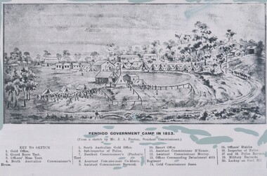
Negative - TOM PATULLO COLLECTION: BENDIGO GOVERNMENT CAMP,1853
Negative print. Bendigo Government Camp,1853, from a sketch by J.A. Panton. Image shows Camp Reserve and notes where individual sections of it were located. Key on bottom of sketch. cottage, miners, bendigo gov.camp, 1853., bendigo gov.camp, 1853. -
 Bendigo Historical Society Inc.
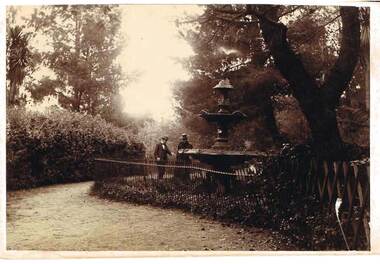
Photograph - FOUNTAIN IN ROSLIND PARK
Photograph - black and white. Written on back of photo -' Fountain in Rosalind Park, old camp reserve. Violet and Mr Baker'. The photo shows a three tier fountain, water emitting from top, surrounded by a simple metal fence. Man and woman standing alongside fence looking at fountain, presumably Violet and Mr. Baker.place, public gardens, rosalind park, fountain in roslind park. bendigo. violet and mr baker. -
 Bendigo Historical Society Inc.
Document - Hustlers, Sheepshead and Deborah lines of reef
Albert Richardson was a mining historian who wrote widely on the mines of the Bendigo Goldfield. The park opposite the Goldmines Hotel in Marong Road, is named in his honour. Five page document, hand written by Albert Richardson on lined foolscap and edited with cross-outs and insertions, . The mines along the Hustlers line of reef and the Sheepshead line of reef are described. Mines listed on Hustlers line of reef: Fortuna Hustlers (1888 - 1913), shaft 2,240 feet at rear of Buckell and Jeffrey's offices; Royal Hustlers Reserve No. 2 - two shafts 'City" 860 feet, now covered by R.S.L. building Pall Mall, steel poppet legs 60 ft high and 'Park Shaft" at rear of Camp Hill School, 1,775 feet, steel poppet legs 60 feet high; Hustlers Hill Group first worked by Jonathan Harris in 1853 and bounded by Valentine, Anderson and Ironbark Creek to the north and Milroy Street to the east, one of first areas worked for quartz reefing. It with Garden Gully line west and Victoria Hill Ironbark, formed by far the richest cross section of the Bendigo Goldfield. Great Extended Hustlers (1865-1921) close to intersection of Anderson Street and Hustlers Road, mullock heap against road and shored up around shaft, steel poppet legs now at Wattle Gully mine, Chewton, large winding machine, air compressor south of shaft and 36 head crushing battery. Hustlers Reef (Old Hustlers) and Hustlers Reef No. 1, two shafts, main 2,210 feet, about 220 yards east of Moran Street and against Fenton Street. , No. 1 shaft 1,140 feet and about 155 yards east of Moran Street. Lansell's Comet, Lightining Hill line, 2.100 feet, on Comet Hill approx 70 yards west of Holmes Road, near Comet Creek, steel poppet legs. United Hustlers and Redan (1876-1918), main Redan, 1,830 feet about 155 yards west of Sandhurst Roead, in line with Comet Hill State School, this hill known as Redan Hill. North, or New Hustlers, once known as Agnew Hustlers, wooden poppet legs, south side, Kneebone Street, Eaglehawk. Derby line, Johnson's No. 3, South Johnson's (east shaft of Collman and Tacchi) 439 feet on west wide of Woods Street, south of Wetherall Street. Paddy's Gully Line, south to north, some shafts - Lansell's 'Sandhurst" ('Needle") Eaglehawk Road shaft 2,425 feet, about 50 yards east of Needle Loops, a brick square sided chimney with Cleopatra Needle top. British American, 789 feet, just south of Holdsworth Road. Collman and Tacchi, main shaft 2,588 feet, 60 yards west of Eaglehawk Road, California Gully. Deborah Line of Reef, The Deborah (1932-1954) shaft 2.017 feet, west of Adams Road and south of Abel Street, Quarry Hill. North Deborah (1937 - 1954) shaft 1,151 feet, Breen Street, Quarry Hill, steel poppet legs. Central Deborah (1939-1954) shaft 1,347 feet Sheepshead line of reef, Lansell's South Red, White and Blue, shaft 2,124 feet, north east of Bellevue Road and 220 yards east of Adams Road. The New Red, White and Blue Consolidated (Big Blue) main shaft 2,416 feet. Lansell's Bendigo Battery 105 head, north of 'Big Blue" on his freehold lease, commenced crushing on 24th February 1895. After closing was erected as the Showground's Industrial Hall, July 1926. North Red, White and Blue, burnt down February 1926, new company 1934, closed 1938. Document is part of the Albert Richardson Collection of Bendigo mining history. bendigo, gold mining, deborah line of reef, sheepshead line of reef, hustlers line of reef, royal hustlers reserve mine, hustlers hill group of mines, great extended hustlers, hustlers reef no. 1, lightning hill line, old comet, collman and tacchi, lansell's comet, north deborah, central deborah, dhrrpdhrsf linr og trrg, new red, white and blue consolidated mine, big blue, lansell's bendigo battery, north red, white and blue mine, albert richardson collection -
 Federation University Historical Collection
Map, Ballaarat Gold Field, 1861, 1861
A party of surveyors camped by Yuille's Swamp (later Lake Wendouree) and surveyed the countryside for a map to be produced by the Geological Survey of Victoria. In November 2004 the Central Highlands Regional Library presented a special edition of 200 copies of the 1861 map reproduced from a copy in their collection. Original 1861 map of Ballarat showing streets and leads. Blue dots indicate gold leads, and red lines indicate auriferous quartz reef and outcrops of quartz veins."Compiled & Drawn from the Survey of Mining Surveyors Davidson, Fitzpatrick and Cowan & the Plans in the Surveyor General's Office by J. Brahe, 21st October 1861. R. Brough Smyth, Secretary for Mines. The Honourable J.B. Humffray, M.L.A. Commr of Mines.”ballarat, map, ballarat east, lake wendouree, survey, mines, robert davidson, ballarat gold field 1861, yuille's swamp, wendouree swamp, little bendigo diggings, gold leads, old post office hill, specimen hill, bakery hill, black hill, dead horse creek, brown hill, pennyweight hill, clayton hill, soldiers hill, golden point, gum tree flat, white flat, poverty hill, chinese village, robert brough smyth, ballarat map 1861, ballaarat vineyard, dead horse gully, deadhorse creek, invermay, black hill flat, gaelic church, police reserve, magpie range, dalton's flat, caadian lead, rifle butts, powder magazine, bathing house, government camp, gold office, chinese, llanberrris, victoria theatre, charlie napier hotel, united states hotel, grape's hoel, clayton's hill, cattleyard hill, free trade hotel, esmond lead, bakery hill, black hill lead, juvenile reformatory, ballarat orphanage, lady barkly lead, triffet's slaughter yard, little bendigo, melbourne road, t. cowan, thomas cowan -
 Bendigo Historical Society Inc.
Document - MCCOLL, RANKIN AND STANISTREET COLLECTION: SCRAPBOOK - WORLD WAR I, 1915
McColl Rankin & Stanistreet. Scrapbook WWI. Exercise book with newspaper cuttings about Australians in WWI. Australia Day, Bendigo Recruits Return, At Upper Reserve, The Receipts, Departure of Troops, Gallipoli, Returned Soldiers, A Woman in War, Bendigo Training Camp, Anzac Day, Bendigo Battalion, Pioneer Cabwoman on the Rank in Bendigo (Mrs. Charlotte Jackson). Pictures from papers in articles. On display at library 21.2.19, in 'These are a few of my favorite things'organization, business, wwi, scrapbook -
 Bendigo Historical Society Inc.
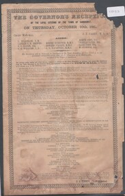
Pamphlet - Agenda for The Govenor's reception by the loyal citizens of the Town of Sandhurst on Thursday 10th October 1861, 25/02/2025
Victorian Govenor's visit to Sandhurst (Bendigo)Agenda for The Govenor's reception by the loyal citizens of the Town of Sandhurst on Thursday 10th October 1861 On the procession appearing in view from the centre of the town, a salute of 13 guns will be fired from the Camp Reserve. Marching along High Street and Pall Mall, to Bull Street, to Hargreaves Street, down Hargreaves Street to Mundy Street and up to the Criterion Hotel, the procession will halt in front of the hotel when his Excellency, as he alights from the carriage, will receive a military salute from the Volunteers, under Captain Anderson. The procession will then proceed up Mundy Street, and along Hargreaves Street, and along Lyttleton Terrace and dissolve in the Market reserve.vice-regal visits -
 Bendigo Historical Society Inc.
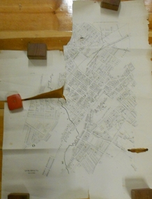
Document - MARKS COLLECTION: PLAN OF SANDHURST CITY CENTRE AND SURROUNDING AREA ( NO. 1 )
Plan on heavy parchment - section neatly cut out of area now Kennington. Written on plan in black print ' Sheet No. 1. Sandhurst'. Plan shows Government Camp, Commissioner's Gully, old cemetery site, manure depot, cattle market, Benevolent Asylum Reserve, railway reserve. Landowners' names on allotments. On bottom lithographed at the Department of Lands and Survey, Melbourne, by D. Henerson, March 12th., 1867 Plan part of George Lansell, Fortuna auction, documents found in wardrobe purchased by Marks family in 1930's.bendigo, planning, sandhurst 1867 -
 Bendigo Historical Society Inc.
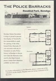
Document - THE POLICE BARRACKS ROSALIND PARK BENDIGO
... Building Camp Reserve Mounted Constable James 'Tiger' Scholes 6438 ...Pale yellow page containing a picture and upstairs and downstairs plans of the Police Barracks, Rosalind Park, Bendigo. On the back is the history of the building and its use over the years since it was completed in 1860. On the 9 November 2002, the Bendigo Senior Secondary College presented a display of Police memorabilia to mark the opening of the refurbished Police Barracks. There were tours of the Barracks, displays and a Mounted Police display with horses. The Official Party was: Mr Graham Bastian, Principal, Bendigo Senior Secondary College, Mr Bob Cameron MP, member for Bendigo West, Ms Jacinta Allan MP, Member for Bendigo East, Ms Willi Carney, Mayor, City of Greater Bendigo, Mr Steve Gibbons MHR, Member for Bendigo and Mr Rob Blachford. There is a running sheet for the opening.buildings, government, police barracks, the police barracks rosalind park bendigo, bendigo senior secondary college, high school, bob marmion, p o flanagan, public works, alfred t snow, john robertson, bendigo goldfield, bendigo gaol, bendigo supreme court building, camp reserve, mounted constable james 'tiger' scholes 6438, education department, city of greater bendigo, graham bastian, willi carney, bob cameron mp, ms jacinta allan mp, steve gibbons mhr, bob blachford -
 Bendigo Historical Society Inc.
Document - Geological Survey of Victoria, Hustlers Line of Reef, Bendigo, April, 2014
Seven men were killed at the Great Extended Hustler's mine disaster on 2nd May 1914 by an explosion of dynamite occurring as the men were waiting at the plat to ascend the mine at the end of their shift. No blame was attached to anyone in the findings of the inquisition. It was unknown what caused the dynamite to explode. This document formed part of the research done at the time by Bendigo Historical Society, of the 100 years commemoration of the mine disaster, held at Hustler's Hill in 2014. Seven page photocopy of Department of Mines, Bulletin, Geological Survey of Victoria, Hustlers Line of Reef, Bendigo, No. 33 by H.S. Whitelaw. Includes plan of Hustlers Royal Reserve No. 2, (main shaft) showing location on Pall Mall, and location of Post Office and Law Courts; plan of location of Hustlers Royal Reserve No. 2 (Park Shaft) showing Jail (sic), Camp Hill State School, two 'lagoons' in between tennis court, croquet court and bowling green; a plan of the Great Extended Hustler's Shaft and two copied images of Hustler's Hill showing mining buildings, poppet heads and chimneys. Comet, K.K., Hustler's No. 1, Old Comet and United Hustler's and Redan Mines are shown in the images. great extended hustlers, goldmining, accident, quartz, mining, k.k. mine, comet mine, hustler's line of reef, old comet, united hustler's, redan -
 Bendigo Historical Society Inc.
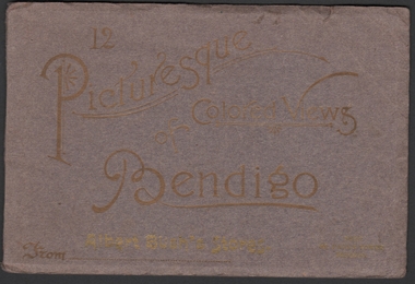
Photograph - Picturesque Colored Views of Bendigo, 1909
Book of twelve coloured postcards - "12 Pictures of Colored Views of Bendigo". 1909 calendar printed in gold lettering on rear cover. Brown card cover with gold lettering. Abbott's Bush Stores (Williamson & Mollison Stores) 1909. Next St. Paul's Tower. Includes Post Office Bendigo, Albert Bush's Stores and Tea Warehouse x 2, Bendigo Fernery x 3, Easter Fair Procession, Queen's Monument Camp Reserve, Fern Pond Camp Reserve, Fountain Charing Cross, Mitchell street, Pall Mall, Town Hall, Hargreaves Street.bendigo, albert bush, tea warehouse