Showing 542 items
matching drainage
-
 Eltham District Historical Society Inc
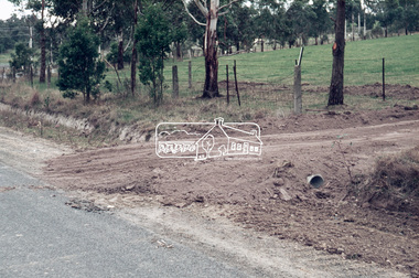
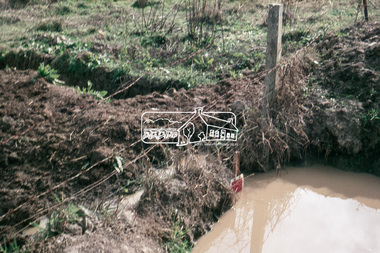
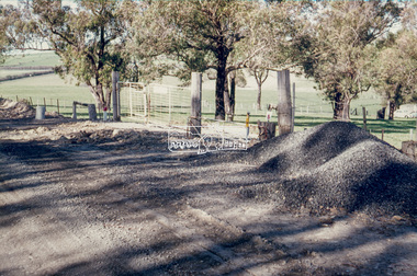
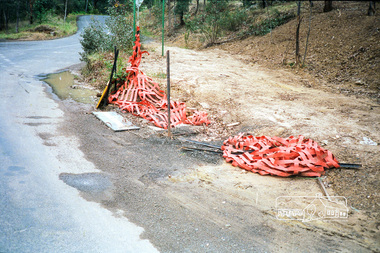
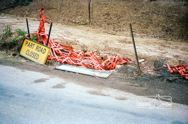
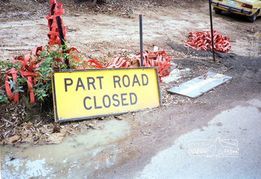
Slide, Post drainage repairs on Bonds Road near Martin property and Montpelier Drive, Lower Plenty, c.July 1972, 1972
Water drainage work undertaken by Eltham Shire Council in Bonds Road, Lower Plenty outside the Martin property opposite Montpelier Drive, July 1972 35 mm colour positive transparency Mount - Agfacolor Service (Blue)Bonds Road (Martin property) 12.10 pm 18.7.72bonds road, drainage works, eltham shire council, infrastructure, lower plenty, martin property, montpelier drive -
 Eltham District Historical Society Inc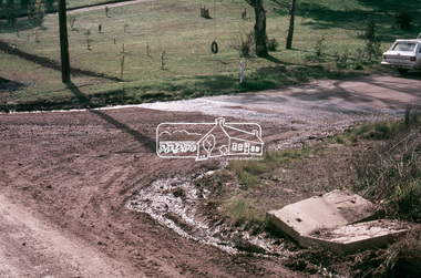
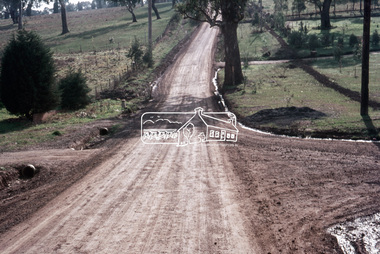
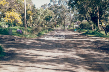
Slide, Looking north post drainage repairs on Bonds Road near Martin property and Montpelier Drive, Lower Plenty, c.July 1972, 1972
Water drainage work undertaken by Eltham Shire Council in Bonds Road, Lower Plenty outside the Martin property opposite Montpelier Drive, July 1972 35 mm colour positive transparency Mount - Agfacolor Service (Blue)Bonds Road (Martin property) 12.10 pm 18.7.72bonds road, drainage works, eltham shire council, infrastructure, lower plenty, martin property, montpelier drive -
 Eltham District Historical Society Inc
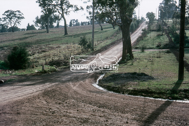
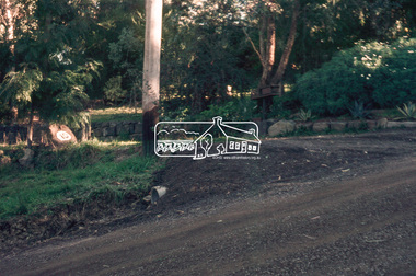
Slide, Post drainage repairs on Bonds Road near Martin property and Montpelier Drive, Lower Plenty, c.July 1972, 1972
Water drainage work undertaken by Eltham Shire Council in Bonds Road, Lower Plenty outside the Martin property opposite Montpelier Drive, July 1972 35 mm colour positive transparency Mount - Agfacolor Service (Blue)Bonds Road (Martin property) 12.10 pm 18.7.72bonds road, drainage works, eltham shire council, infrastructure, lower plenty, martin property, montpelier drive -
 Eltham District Historical Society Inc
Slide, Post drainage repairs on Bonds Road near Martin property and Montpelier Drive, Lower Plenty, c.July 1972, 1972
Water drainage work undertaken by Eltham Shire Council in Bonds Road, Lower Plenty outside the Martin property opposite Montpelier Drive, July 1972 35 mm colour positive transparency Mount - Agfacolor Service (Blue)Bonds Road (Martin property) 12.10 pm 18.7.72bonds road, drainage works, eltham shire council, infrastructure, lower plenty, martin property, montpelier drive -
 Orbost & District Historical Society
cash book, first half 20th century
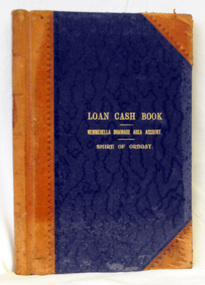
This ledger was used by the Shire of Orbost to record transactions relating bto the Newmerella Drainage Area from 1927 to 1950. The item was donated to Orbost & District Historical society from P.R.O.V. as a Place of Deposit (POD) item for safe keeping by a local history group or museum. The shire covered an area of 9,347 square kilometres and existed from 1892 until 1994 when it became part of the East Gippsland Shire Council. Orbost was at first included in the Bairnsdale Shire from 1882 and was later part of the Tambo Shire. Because of travelling distances the Croajingalong Shire was created in 1892 (name changed to Orbost Shire 17.2.1893 with James Cameron as the first Shire President. In 1994 it amalgamated to become part of East Gippsland Shire Council.This item is a hand-written record of the accounts of the Orbost Shire local government. It pre-dates computer records. The Orbost Shire Council no longer exists having been absorbed into the East Gippsland Shire Council. A ledger with a black cover and brown binding. It has marbled end covers. It contains handwritten records of transactions relating to the Newmerella Drainage Area. On the front cover in gold print is "LOAN CASH BOOK (underlined) NEWMERELLA DRAINAGE AREA ACCOUNT (underlined) SHIRE OF ORBOST". on spine - "Newmerella Drainage Area Cash Book" in gold print.orbost-shire-council ledger accounts newmerella-drainage-area -
 National Vietnam Veterans Museum (NVVM)
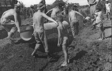
Photograph, Laying Drainage Pipe
A black and white photograph of an Engineering Officer supervising diggers from 17 Construction Squadron based at the 1st Australian Task Force Base, Nui Dat, Phuoc Tuy Province, South Vietnam, as they lay large drainage pipes along the roadway into Hoa Long village.photograph, 17 const sqn, engineers, 1st atf base, nui dat, phuoc tuy province, hoa long, gibbons collection catalogue -
 University of Melbourne, Burnley Campus Archives
Letter, S. Allan Johnson, c. 1971
Critical letter to Director from S. Allan Johnson re drainage. This letter (original and carbon copy) is addressed to the Director School of Horticulture Burnley. It is from S. Allan Johnson who gives the address of Henry George League, 18 George Parade, Melbourne. It is undated , and suggests that two authors are Mr Lothian and Miss N Chisholm, graduates of Burnley offer incorrect information on drainage in gardens. He includes 3 pages of instructions on drainage in gardens. There is a handwriten note on the back of the copy. The letter is full of typing and spelling mistakes. The brown paper envelope is addressed to the Burnley Horticultural Gardens, Burnley and is not postmarked. There is no stamp. (Hand delivered.) Letter to Director, Burnley School of Horticulture re drainage s. allan johnson, drainage, gardens drainage, incorrect garden drainage, criticism of garden drainage practice, horticulture drainage instructions -
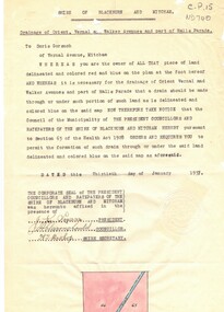 Whitehorse Historical Society Inc.
Document, Drainage of, 30/01/1937 12:00:00 AM
Notice from Shire of Blackburn and Mitcham to Doris Gorsuch, Vernal Avenue, Mitcham requiring access for forming a drain, 30 January 1937.Notice from Shire of Blackburn and Mitcham to Doris Gorsuch, Vernal Avenue, Mitcham requiring access for forming a drain, 30 January 1937.Notice from Shire of Blackburn and Mitcham to Doris Gorsuch, Vernal Avenue, Mitcham requiring access for forming a drain, 30 January 1937.shire of blackburn and mitcham, gorsuch, doris, drainage, vernal avenue, mitcham -
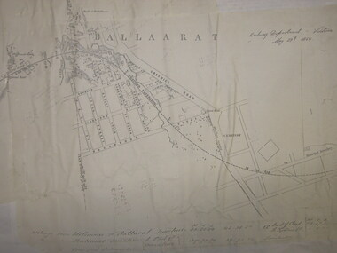 Federation University Historical Collection
Plan, Ballarat Railway Plan, 1860, 29/05/1860
This plan was created by the Railway Department, Victoria.Photocopy of the Melbourne to Ballarat via Geelong Railway plan. The section is the area adjoining Bakery Hill, Ballarat. The plan shows the Yarrowee River, central Ballarat, Government Camp, Imperial Hotel, Union Hotel, Crown hotel, electric Telegraph line, Eureka Lead, Black Hill Lead, Ballaarat Old Cemetery., Bank of Australasia.ballarat railway, ballarat -
 Whitehorse Historical Society Inc.
Letter - Correspondence, Mr T. McClelland correspondence about drainage, 1937
Letter from resident Mr T. McClelland to Shire of Blackburn and Mitcham about the condition of a pitched drain in front of his dwelling in Whitehorse Road, Mitcham.Letter from resident Mr T. McClelland to Shire of Blackburn and Mitcham about the condition of a pitched drain in front of his dwelling in Whitehorse Road, Mitcham. With carbon copy of reply from the Shire Secretary.Letter from resident Mr T. McClelland to Shire of Blackburn and Mitcham about the condition of a pitched drain in front of his dwelling in Whitehorse Road, Mitcham.drainage, mcclelland, thomas robert, bishop, herbert thomas, shire of blackburn and mitcham, whitehorse road, mitcham -
Whitehorse Historical Society Inc.
Article, Nunawading residents see red over drainage scheme 'waste', 1993
Residents are concerned that the proposed easement drain in Esdale Street will not solve flooding problems.Residents are concerned that the proposed easement drain in Esdale Street will not solve flooding problems.Residents are concerned that the proposed easement drain in Esdale Street will not solve flooding problems.city of nunawading., esdale street, nunawading, springfield road, nunawading, swingler, phillipa, neal, andrew, drainage -
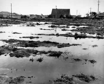 City of Kingston
Photograph - Black and white, c. 1958
Unsealed roads and drainage problems created difficulties for those living in Beaumaris during the 1950sBlack and white image depicting the Balcombe Road and Haywood Street, Beaumaris. Unsealed roads and drainage problems have created boggy slushy land. There are houses in the background, indicating people live in the area.Handwritten in red ink on reverse: 90% Handwritten in blue ink on reverse: 2193beaumaris, roads, drainage, water logged, housing -
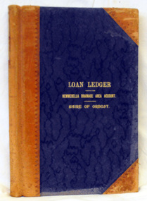 Orbost & District Historical Society
ledger, first half 20th century
This ledger was used by the Shire of Orbost from 1927 -1940. The item was donated to Orbost & District Historical society from P.R.O.V. as a Place of Deposit (POD) item for safe keeping by a local history group or museum. The shire covered an area of 9,347 square kilometres and existed from 1892 until 1994 when it became part of the East Gippsland Shire Council. Orbost was at first included in the Bairnsdale Shire from 1882 and was later part of the Tambo Shire. Because of travelling distances the Croajingalong Shire was created in 1892 (name changed to Orbost Shire 17.2.1893 with James Cameron as the first Shire President. In 1994 it amalgamated to become part of East Gippsland Shire Council. This item is a handwritten record of the accounts of the Orbost Shire local government. It pre-dates computer records. The Orbost Shire Council no longer exists having been absorbed by the East Gippsland Shire Council.A ledger with a black cover and brown leather binding. It has marbled end pages. On the front cover in gold print is " LOAN LEDGER (underlined) NEWMERELLA DRAINAGE AREA ACCOUNT (underlined) SHIRE OF ORBOST.on spine - "Newmerella Drainage Area Loan Ledger"ledger orbost-shire newmerella-drainage-area accounts -
Port Melbourne Historical & Preservation Society
Document, Melbourne and Metropolitan Board of Works, 31 Oct 1935
Documentation of drainage works in 1935 for 141 Bridge St.Plan of drainage 31/10/1935. Details the Melbourne and Metropolitan Board of Works drainage plan for part of Port Melbourne. 141 Bridge St, Port MelbourneHand written details around blueprint of area. Notes made on right hand side and 3 signatures at the bottom.built environment - civic, built environment - domestic, engineering - board of works, melbourne and metropolitan board of works, mmbw, m h grover, r f bentley -
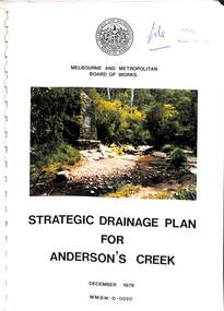 Ringwood and District Historical Society
Book, Strategic Drainage Plan For Anderson's Creek, 1978
Melbourne and Metropolitan Board of Works 1988 report on physical characteristics of Anderson's Creek and development of management strategies formulated in consultation with Cities of Croydon, Doncaster & Templestowe, and Ringwood, in which the Anderson's Creek Basin is located. Foreword by Alan H. Croxford, M.M.B.W. Chairman. -
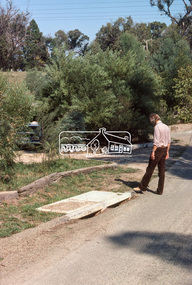
 Eltham District Historical Society Inc
Slide - Photograph, Eltham Shire Council, Unidentified road; Infrastructure works, roads, footpaths and drainage, Shire of Eltham, c.1972
35mm colour positive transparency blue Agfacolour Service plastic mount1972, footpaths and gutters, infrastructure, road construction, road drainage, roadworks, shire of eltham, unidentified -
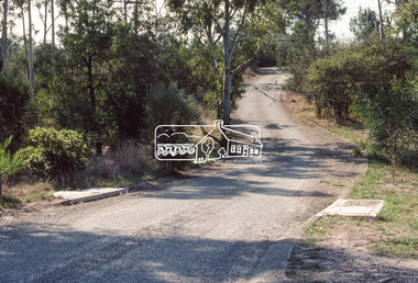
 Eltham District Historical Society Inc
Slide - Photograph, Eltham Shire Council, Unidentified road, possibly Kangaroo Ground; Infrastructure works, roads, footpaths and drainage, Shire of Eltham, c.1972
35mm colour positive transparency blue Agfacolour Service plastic mount1972, footpaths and gutters, infrastructure, road construction, road drainage, roadworks, shire of eltham, unidentified, kangaroo ground -
 Eltham District Historical Society Inc
Slide - Photograph, Eltham Shire Council, Unidentified road; Infrastructure works, roads, footpaths and drainage, Shire of Eltham, c.1972
35mm colour positive transparency blue Agfacolour Service plastic mount1972, footpaths and gutters, infrastructure, road construction, road drainage, roadworks, shire of eltham, unidentified -
 Eltham District Historical Society Inc
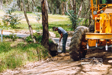
Slide, Drainage under driveway near No. 10 Bolton Street, Lower Plenty, 18 July 1972, 1972
Reconstruction works by Eltham Shire Council, Bolton Street, Eltham, 18 July 197235 mm colour positive transparency Mount - Agfacolor Service (Blue)bolton steet, eltham, eltham shire council, infrastructure, lower plenty, road construction, rosehill road -
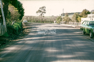
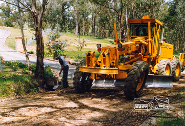
 Eltham District Historical Society Inc
Photograph, Road and drainage maintenance, Shire of Eltham, c.Oct 1987, 1987
Colour photographdrainage works, infrastructure, road maintenance, shire of eltham -
 Eltham District Historical Society Inc
Photograph, Road and drainage maintenance, Shire of Eltham, c.Oct 1987, 1987
Colour photographdrainage works, infrastructure, road maintenance, shire of eltham -
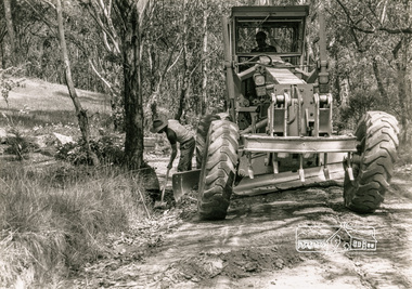 Eltham District Historical Society Inc
Photograph, Road and drainage maintenance, Shire of Eltham, c.Oct 1987, 1987
Black and white photographdrainage works, infrastructure, road maintenance, shire of eltham -
 Eltham District Historical Society Inc
Photograph, Water drainage pits with double side entry, Riverhill Drive, Lower Plenty, c.March 1981, 1981
Infrastructure features used by Eltham Shire Council in the construction of Riverhill Drive, Lower Plenty, c.March 198135mm colour positive transparency Kodak Kodachrome cardboard mountinfrastructure, lower plenty, riverhill drive, road construction, streets -
 Eltham District Historical Society Inc
Photograph, Water drainage pits at low point, Riverhill Drive, Lower Plenty, c.March 1981, 1981
Infrastructure features used by Eltham Shire Council in the construction of Riverhill Drive, Lower Plenty, c.March 198135mm colour positive transparency Kodak Kodachrome cardboard mount Also Kodak Enlargement of slide 27 x 35.5 cminfrastructure, lower plenty, riverhill drive, road construction, streets -
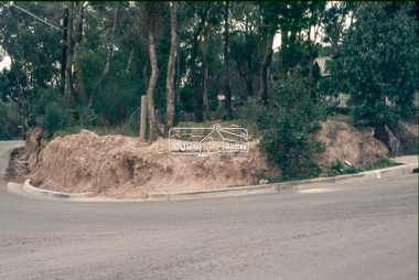
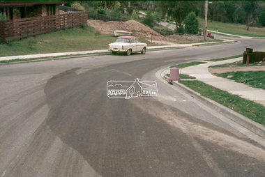
 Eltham District Historical Society Inc
Photograph, Council road and drainage works, believed to be Reynolds Road near Thompson Crescent, c.Nov. 1991
Roll of 35mm colour negative film, 7 stripsKodak GA 100 5095shire of eltham, roadworks, reynolds road, thompson crescent -
 Eltham District Historical Society Inc
Photograph, Council road and drainage works, believed to be Reynolds Road near Thompson Crescent, c.Nov. 1991
Roll of 35mm colour negative film, 7 stripsKodak GA 100 5095shire of eltham, roadworks, reynolds road, thompson crescent -
 Eltham District Historical Society Inc
Photograph, Council road and drainage works, believed to be Reynolds Road near Thompson Crescent, c.Nov. 1991
Roll of 35mm colour negative film, 7 stripsKodak GA 100 5095shire of eltham, roadworks, reynolds road, thompson crescent