Showing 10157 items
matching england.
-
 Clunes Museum
Container - BOTTLE, WHIFFEN & SONS LONDON - ENGLAND
USED BY PHARMACY IN CLUNES.SMALL BROWN BOTTLE WITH CORK AND LABEL.HOMATROPINE HYDROBRON - POISON. MANUFACTURED BY WHIFFEN AND SONS. LTD. BATTERSEA. LONDON - ENGLANDlocal history, medicine, pharmacy, shrigley - chemist -
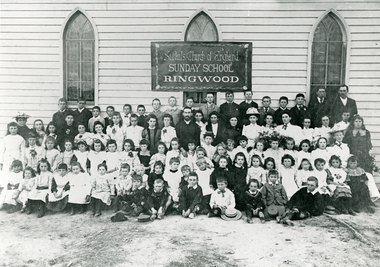 Ringwood and District Historical Society
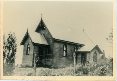
Photograph, St. Paul's Church of England Sunday School Cnr. Pratt St. and Whitehorse Rd. Ringwood - 1890
Black and white photograph of group of children and some adults in front of a church bearing a sign, "St. Paul's Church of England Sunday School, Ringwood".Typed below photograph, "St. Pauls Church of England Sunday School Cnr. Pratts and Whitehorse Rds. 1890". -
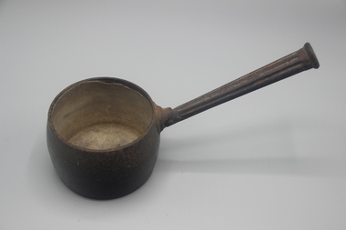 Port Fairy Historical Society Museum and Archives
Functional object - Pot, cooking, c. 1900s
cooking pot (saucepan) rounded sides straight fluted handle, Inside enamelled, colour blackT&C Clark & Co/ England/ No 2 1/2 pints/ first qualitylocal history, domestic items, cooking -
Glenelg Shire Council Cultural Collection
Souvenir - Souvenir Cup - Portland Victoria, n.d
Identifying numbers: 5873 a, b White, fine bone china cup and saucer. Image of Loreto Convent and All Saints Church on both cup and saucer. Made in England.Front: 'View at Portland Vic' Back: Maker's stamp and crest - 'Royal Stafford Guaranteed English Bone China Made in England'city of portland, portland victoria -
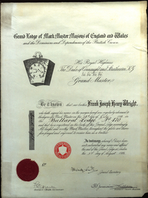 Federation University Historical Collection
Certificate, Grand Lodge of Markmaster Masons of England and Wales, 1933, 03/08/1933
White paper certificate with printing and handwriting. It is a certificate of the Grand Lodge of Markmaster Masons of England and Wales made out to Frank Joseph Henry Wright on 14 July 1933 at the Ballarat Lodge No 470.Signed 'Frank Wright"frank wright, freemason, mason, lodge, grand lodge, mark masons, seal, certificate, ballarat lodge no 470 -
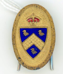 Ringwood and District Historical Society
Badge - Lapel pin, Badge from Ringwood, Hampshire, England
Badge from Ringwood, Hampshire, England. Oval, gilt, with red crown above shield with three birds and cross hatching. Made of enamel. Spring wire fastening on back, held by two loops. (Unidentified motif) -
Glenelg Shire Council Cultural Collection
Souvenir - Souvenir Saucer - Portland Victoria, n.d
Identifying numbers: 5873 a, b White, fine bone china saucer. (Part of a cup and saucer set) Image of Loreto Convent and All Saints Church on both cup and saucer. Made in England.Front: 'View at Portland Vic' Back: Maker's stamp and crest - 'Royal Stafford Guaranteed English Bone China Made in England'city of portland, portland victoria -
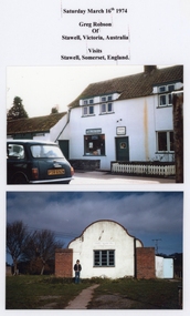 Stawell Historical Society Inc
Photograph, Stawell in Somerset England – 2 Photos
Stawell – Somerset England – 2 Views Post Office and Village Hall. Two colour laminated photographs of white buildings, one with a person out the front. Yellow envelope in folder with 5 more photos of Stawell, Somerset Englandstawell -
Clunes Museum
Container - GLUE POT, CLARK & CO. ENGLAND
GLUE POT (2 PIECES) SMALLER POT FITS IN LARGER POT. HANDLES ON BOTH PIECES. STICKER MARKED "95" BLUE PAINT ON LARGER POT.MARKINGS ON BASE OF LARGER POT (PARTLY ILLEGIBLE) CLARK & CO. ENGLAND. FIRST QUALITY A/C 3/0local history, trades, tools -
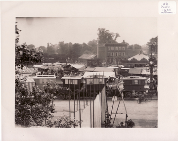 Whitehorse Historical Society Inc.
Photograph, Mitcham, Surrey England, 1900
Black and white photo of Mitcham Fair on Fair Green by Thos. Francis, London House, Mitcham, England. 1900. The photo overlaps and give a panorama of the Fair as far as could been seen from Ravensbury House (J.D.Drewett). See NP1438mitcham, england -
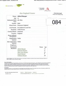 Greensborough Historical Society
Administrative record - Census, Alfred Mayger: 1841 England Census, 1841_
Background to the Mayger family in EnglandMayger family were a pioneer family in the Greensborough area3 x A4 pages. Citation from the 1841 England Census for Alfred Mayger, accessed via Ancestry.co. Also pages from National Burial Index detailing Mayger burials in Somerset.mayger family, alfred mayger -
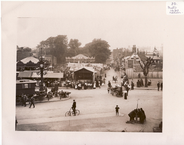 Whitehorse Historical Society Inc.
Photograph, Mitcham, England, 1900
Black and white photo of Black and white photo of Mitcham Fair on Fair Green by Thos. Francis, London House, Mitcham, England. 1900. The photo overlaps and give a panorama of the Fair as far as could been seen from Ravensbury House (J.D.Drewett). See NP1437mitcham, surrey, england -
Glenelg Shire Council Cultural Collection
Postcard, MURRAY VIEWS, GYMPIE QUEENSLAND, CHURCH OF ENGLAND, CASTERTON VIC, c. 1960
Sourced from Casterton Town Hall (former Shire of Glenelg)Black and white postcard, white border, front and side view of Church of England, Casterton. No. 22 in a series by Murray Views.Front: 'MURRAY VIEWS NO.22 CHURCH OF ENGLAND, CASTERTON, VIC' in bottom border. Back: Details of maker. Blue biro line, arrowed each end, drawn across width of card, 3" written above line. -
 St Kilda Historical Society
Photograph, Yeoman & Co, Samuel England Jeans, Mayor of St Kilda
Studio portrait of Samuel England Jeans, Mayor of St Kilda 1888-1889 in mayoral robesSepia photograph on card, mounted, fair conditionSamuel England Jeans, Mayor of St Kilda 1888-1889 -
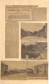 Ringwood and District Historical Society
Newspaper - Clipping, The Age, Namesake Towns: Images of Ringwood Hampshire England and Ringwood Victoria. From 'The Age' 4 April 1931, 4-Apr-31
Article as part of a series comparing Ringwood, Hampshire, England and Ringwood, Vic.. Population details, industry, houses and environs. 4 B&W pictures two of Ringwood ,England and two of Ringwood , Vic. depicting streetscapes and buildings.Newspaper cuttings on cream coloured cardboard from 'The Age' 4 April 1931 with 2 B&W photos of Ringwood, Hampshire, England and 2 B&W photos of Ringwood ,Victoria ,Clocktower in background and old Town Hall. Printed text. -
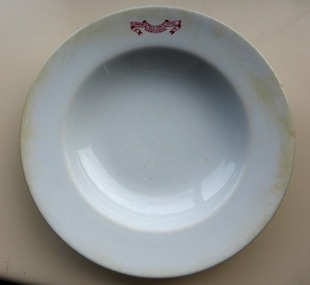 Warrnambool and District Historical Society Inc.
Domestic object - White dinner bowl Plowright's Western Hotel, Grindley Hotel Ware, England, According to date 1913
Charles Plowright operated the Western Hotel on the corner of Timor and Kepler Streets from 1910 until around 1919. It was built in 1869 by William O’Brien, having been designed by Andrew Kerr. It was a staging place for the Cobb & Co Coaches. A common commercial product with which many people could identify. The Western Hotel is a common Warrnambool landmark built around 1869, it was one of the earliest hotels and operates to this day. Plain white soup bowl with flat rim. Red printed logo printed on rim.Plowrights Western Hotel Warrnambool printed in red on rim of bowl. “Grindley Hotel Ware England. Vitrified” stamped on base below emblem of crown. Date stamped in china 1 13warrnambool, plowright, western hotel, grindley china -
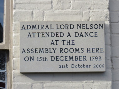 Ballarat Heritage Services
Photograph - Colour, Plaque, Admiral Lord Nelson, Aylsham, England
PLaque at Aylsham, England.aylsham, lord nelson -
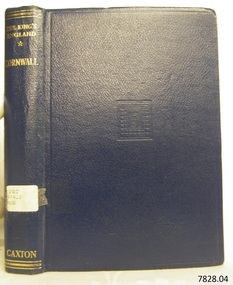 Flagstaff Hill Maritime Museum and Village
Book, The Kings England Cornwall
This item is from the ‘Pattison Collection’, a collection of books and records that was originally owned by the Warrnambool Mechanics’ Institute, which was founded in Warrnambool in 1853. By 1886 the Warrnambool Mechanics’ Institute (WMI) had grown to have a Library, Museum and Fine Arts Gallery, with a collection of “… choice productions of art, and valuable specimens in almost every branch and many wonderful national curiosities are now to be seen there, including historic relics of the town and district.” It later included a School of Design. Although it was very well patronised, the lack of financial support led the WMI in 1911 to ask the City Council to take it over. In 1935 Ralph Pattison was appointed as City Librarian to establish and organise the Warrnambool Library as it was then called. When the WMI building was pulled down in 1963 a new civic building was erected on the site and the new Warrnambool Library, on behalf of the City Council, took over all the holdings of the WMI. At this time some of the items were separated and identified as the ‘Pattison Collection’, named after Ralph Pattison. Eventually the components of the WMI were distributed from the Warrnambool Library to various places, including the Art Gallery, Historical Society and Flagstaff Hill. Later some were even distributed to other regional branches of Corangamite Regional Library and passed to and fro. It is difficult now to trace just where all of the items have ended up. The books at Flagstaff Hill Maritime Village generally display stamps and markings from Pattison as well as a variety of other institutions including the Mechanics’ Institute itself. RALPH ERIC PATTISON Ralph Eric Pattison was born in Rockhampton, Queensland, in 1891. He married Maude Swan from Warrnambool in 1920 and they set up home in Warrnambool. In 1935 Pattison accepted a position as City Librarian for the Warrnambool City Council. His huge challenge was to make a functional library within two rooms of the Mechanics’ Institute. He tirelessly cleaned, cleared and sorted a disarrayed collection of old books, jars of preserved specimens and other items reserved for exhibition in the city’s museum. He developed and updated the library with a wide variety of books for all tastes, including reference books for students; a difficult task to fulfil during the years following the Depression. He converted all of the lower area of the building into a library, reference room and reading room for members and the public. The books were sorted and stored using a cataloguing and card index system that he had developed himself. He also prepared the upper floor of the building and established the Art Gallery and later the Museum, a place to exhibit the many old relics that had been stored for years for this purpose. One of the treasures he found was a beautiful ancient clock, which he repaired, restored and enjoyed using in his office during the years of his service there. Ralph Pattison was described as “a meticulous gentleman whose punctuality, floorless courtesy and distinctive neat dress were hallmarks of his character, and ‘his’ clock controlled his daily routine, and his opening and closing of the library’s large heavy doors to the minute.” Pattison took leave during 1942 to 1945 to serve in the Royal Australian Navy, Volunteer Reserve as Lieutenant. A few years later he converted one of the Museum’s rooms into a Children’s Library, stocking it with suitable books for the younger generation. This was an instant success. In the 1950’s he had the honour of being appointed to the Victorian Library Board and received more inspiration from the monthly conferences in Melbourne. He was sadly retired in 1959 after over 23 years of service, due to the fact that he had gone over the working age of council officers. However he continued to take a very keen interest in the continual development of the Library until his death in 1969. The Pattison Collection, along with other items at Flagstaff Hill Maritime Village, was originally part of the Warrnambool Mechanics' Institute’s collection. The Warrnambool Mechanics’ Institute Collection is primarily significant in its totality, rather than for the individual objects it contains. Its contents are highly representative of the development of Mechanics' Institute libraries across Australia, particularly Victoria. A diversity of publications and themes has been amassed, and these provide clues to our understanding of the nature of and changes in the reading habits of Victorians from the 1850s to the middle of the 20th century. The collection also highlights the Warrnambool community’s commitment to the Mechanics’ Institute, reading, literacy and learning in the regions, and proves that access to knowledge was not impeded by distance. These items help to provide a more complete picture of our community’s ideals and aspirations. The Warrnambool Mechanics Institute book collection has historical and social significance for its strong association with the Mechanics Institute movement and the important role it played in the intellectual, cultural and social development of people throughout the latter part of the nineteenth century and the early twentieth century. The collection of books is a rare example of an early lending library and its significance is enhanced by the survival of an original collection of many volumes. The Warrnambool Mechanics' Institute’s publication collection is of both local and state significance. The King's England - Cornwall England's Farthest South Edited by Arthur Mee Publisher:The Caxton Publishing Co Label on spine cover with typed text PAT 914.2 MEE Pastedown front endpaper has sticker from Warrnambool Public Library covered by a sticker from Corangamite Regional Library Service Front loose endpaper has a stamp from Corangamite Regional Library Servicewarrnambool, shipwrecked-coast, flagstaff-hill, flagstaff-hill-maritime-museum, maritime-museum, shipwreck-coast, flagstaff-hill-maritime-village, shipwrecked-artefact, book, pattison collection, warrnambool library, warrnambool mechanics’ institute, ralph eric pattison, corangamite regional library service, warrnambool city librarian, mechanics’ institute library, victorian library board, warrnambool books and records, warrnambool children’s library, great ocean road, the king's england - cornwall, the king's england, arthur mee -
 Mt Dandenong & District Historical Society Inc.
Photograph, Church of England, Olinda
Church of England. Monash Avenue, Olinda. The descriptive text on the reverse of this photograph was hand written by John Lundy-Clarke.Church of England Olinda When the church was built it faced on to the main Mt Dandenong Road but the road was deviated in and the main road section in front of the Village Settlement blocks was named Monash Avenue. The chapel built on Mrs Warner’s land on Mernda Road (later Coonara Road) was shifted in 1936 by Dick Mitlan using Jack Clarkes Ford truck as traction plant. church of england, olinda, monash avenue -
 Greensborough Historical Society
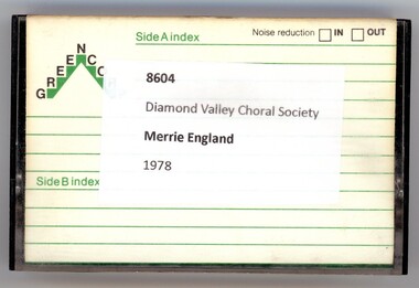
Audio - Audio Cassette, Diamond Valley Choral Society, Merrie England, performed by Diamond Valley Choral Society 1978, 08/10/1979
A recording of Merrie England, an English comic opera in 2 acts by Edward German, first performed in 1902. This performance is by the Diamond Valley Choral Society on 08/10/1979, venue unknown.1 audio cassette in clear plastic caseHandwritten on cassette: "Merrie England DVCS 8-10-79".diamond valley choral society, merrie england (opera), edward german -
 Ballarat Heritage Services
Photograph - Colour, Earth Banks, Old Sarum, England, 2016, 01 November 2016
William the Conqueror inherited Old Sarum from the last Saxon king of England. It was an ideal site for a royal castle. It was here in 1070 that William paid off his army after a long and bitter campaign in northern England. It was here in 1086 that he called together all the major landholders in England so they could swear allegiance to him. It was a crucial moment. The Domesday Book was being written, a threatened Viking invasion had only just been averted and William's eldest son was in armed rebellion. Old Sarum was an important place where this Norman king of England held power. In 1794 the Ordnance Survey set out to check the accuracy of the first mapping of Southern England, which had begun ten years earlier. From a point just below Old Sarum Lieutenant William Mudge laid out a base-line 36,574 feet (11,253 metres) long. From each end of the line the positions of distant places were plotted using a huge theodolite made in 1791 by Jesse Ramsden. The accuracy of the process, which was repeated all over England, depended on Jesse Ramsden's craftsmanship and on William Mudge's surveying skill in setting out this first base-line from Old Sarum. The nearer end of Mudge's line is marked by an inscribed stone beside the modern A345 at Old Sarum. ordnance survey, william mudge, jesse ramsden, william the conqueror, old sarum, saxon, 1086, england -
 Ballarat Heritage Services
Photograph - Colour, Earth Banks, Old Sarum, England, 01 November 2016
William the Conqueror inherited Old Sarum from the last Saxon king of England. It was an ideal site for a royal castle. It was here in 1070 that William paid off his army after a long and bitter campaign in northern England. It was here in 1086 that he called together all the major landholders in England so they could swear allegiance to him. It was a crucial moment. The Domesday Book was being written, a threatened Viking invasion had only just been averted and William's eldest son was in armed rebellion. Old Sarum was an important place where this Norman king of England held power. In 1794 the Ordnance Survey set out to check the accuracy of the first mapping of Southern England, which had begun ten years earlier. From a point just below Old Sarum Lieutenant William Mudge laid out a base-line 36,574 feet (11,253 metres) long. From each end of the line the positions of distant places were plotted using a huge theodolite made in 1791 by Jesse Ramsden. The accuracy of the process, which was repeated all over England, depended on Jesse Ramsden's craftsmanship and on William Mudge's surveying skill in setting out this first base-line from Old Sarum. The nearer end of Mudge's line is marked by an inscribed stone beside the modern A345 at Old Sarum. ordnance survey, william mudge, jesse ramsden, william the conqueror, old sarum, saxon, 1086, england -
 Ballarat Heritage Services
Photograph - Colour, Stonework, Old Sarum, England, English Heritage Site, 01 November 2016
William the Conqueror inherited Old Sarum from the last Saxon king of England. It was an ideal site for a royal castle. It was here in 1070 that William paid off his army after a long and bitter campaign in northern England. It was here in 1086 that he called together all the major landholders in England so they could swear allegiance to him. It was a crucial moment. The Domesday Book was being written, a threatened Viking invasion had only just been averted and William's eldest son was in armed rebellion. Old Sarum was an important place where this Norman king of England held power. In 1794 the Ordnance Survey set out to check the accuracy of the first mapping of Southern England, which had begun ten years earlier. From a point just below Old Sarum Lieutenant William Mudge laid out a base-line 36,574 feet (11,253 metres) long. From each end of the line the positions of distant places were plotted using a huge theodolite made in 1791 by Jesse Ramsden. The accuracy of the process, which was repeated all over England, depended on Jesse Ramsden's craftsmanship and on William Mudge's surveying skill in setting out this first base-line from Old Sarum. The nearer end of Mudge's line is marked by an inscribed stone beside the modern A345 at Old Sarum. ordnance survey, william mudge, jesse ramsden, william the conqueror, old sarum, saxon, 1086, england -
 Ballarat Heritage Services
Photograph - Colour, Stonework, Old Sarum, England, English Heritage Site, 2016, 01 November 2016
William the Conqueror inherited Old Sarum from the last Saxon king of England. It was an ideal site for a royal castle. It was here in 1070 that William paid off his army after a long and bitter campaign in northern England. It was here in 1086 that he called together all the major landholders in England so they could swear allegiance to him. It was a crucial moment. The Domesday Book was being written, a threatened Viking invasion had only just been averted and William's eldest son was in armed rebellion. Old Sarum was an important place where this Norman king of England held power. In 1794 the Ordnance Survey set out to check the accuracy of the first mapping of Southern England, which had begun ten years earlier. From a point just below Old Sarum Lieutenant William Mudge laid out a base-line 36,574 feet (11,253 metres) long. From each end of the line the positions of distant places were plotted using a huge theodolite made in 1791 by Jesse Ramsden. The accuracy of the process, which was repeated all over England, depended on Jesse Ramsden's craftsmanship and on William Mudge's surveying skill in setting out this first base-line from Old Sarum. The nearer end of Mudge's line is marked by an inscribed stone beside the modern A345 at Old Sarum. ordnance survey, william mudge, jesse ramsden, william the conqueror, old sarum, saxon, 1086, england